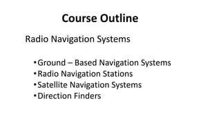
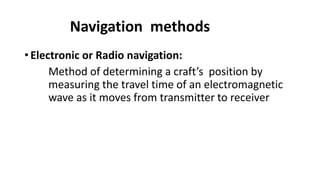
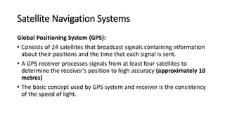
SlideShare a Scribd company logo
Navigation Aids
By Dr Paul Fahamuel Mmbaga
Course Outline
Introduction
•Navigation terms
•Definition of Navigation
Course Outline
Radio Navigation Systems
•Ground – Based Navigation Systems
•Radio Navigation Stations
•Satellite Navigation Systems
•Direction Finders
Course Outline
Introduction to Radio Astronomy
•Definition of Radio Astronomy
•Atmospheric Windows
•Radio Telescopes
•Radio Interferometry
•Astronomical sources
Course Outline
Aircraft – Landing Systems
•Instrument Landing System (ILS)
•Ground – Controlled Approach (GCA)
System
•Microwave Landing System
Course Outline
Underwater Navigation
•The Echo sounder
•The Doppler Log
•Underwater Navigation Aids Transducers
Navigation terms
Angle of cut: Where lines from two aircraft cut
Approach path: Path between where aircraft
starts descending and point of touch down
Navigation terms
• Azimuth: Angle of horizontal plane with respect to the true North
Navigation terms
• Back course: Area behind localizer
• Coherent pulses: Whose phase of rf cycles within a pulse is retained
for measurement purposes.(show the phase difference between the
transmitted and received pulse)
Navigation terms
• Cone of Ambiguity: In very high frequency omnidirectional radio-
range (VOR) and Tactical air Navigation (TACAN),cone of ambiguity is a
conical volume of air space above beacon in which bearing
information is unreliable.
Navigation terms
• Cone of Silence: Conical volume above antenna where field strength
is low
• Crab angle: Correction angle to compensate for wind drift. Angular
difference between course and heading
Navigation terms
• Decision gate: The point at which a pilot should decide to land even if
there is a misapproach.
• Pitch: Angular displacement between longitudinal axis of aircraft and
the horizontal
• Roll: Angular displacement between transverse axis of vehicle and the
horizontal
Navigation terms
• Runway Visual Range (RVR): Forward distance along runway during
landing approach
Navigation terms
• Yaw:
The angle between a line in the direction of flight and a plane through
the longitudinal and vertical axes of an aircraft
What is navigation?, Survey?
• Navigation can be defined as the means by which a craft is
given guidance to travel from one known location to another.
Survey can be defined as to examine and record the features
• Alternatively, navigation is a process or technique used for
directing the movement of a vehicle (aeroplane, ship, missile
etc) from one position to another along the desired
trajectory.
• When we navigate, it is necessary to determine where we
are, how to go from where we are to where we want to be.
Navigation methods
Five practical methods of navigation:
• Piloting: This consists of fixing a craft’s position with respect to
familiar landmarks.
• It is the simplest and most ancient method of navigation.
• Dead Reckoning: Method of determining position of a craft by
extrapolating a series of measured velocity increments
• Originally this was called “ded reckoning” for “deduced reckoning”, but
newspaper reporters called it “dead reckoning” and made the name popular
Navigation methods
• Celestial Navigation: Method of computing position from precisely
timed sightings of the celestial bodies, including the stars and the
planets
• Inertial navigation: Method of determining a craft’s position by using
computer, motions sensors (accelerometers) and rotation sensors
(gyroscopes) to continuously updating the position based on the
previous location and velocity.
Navigation methods
• Electronic or Radio navigation:
Method of determining a craft’s position by
measuring the travel time of an electromagnetic
wave as it moves from transmitter to receiver
Generalized navigation system (Block
diagram)
Electronic
Navigational
Aids
Pilot’s
Commands
(in case the
vehicle is
manned one)
Motion
Sensor
Pilot’s
Displays
Control
System
Processor
(GN & C)
Radio Navigation System
Radio navigation can be broken into two major
classifications:
• Active radio navigation system
• Passive radio navigation system
Satellite Navigation Systems
Transit System
• Specialized receivers tuned to the transmissions of polar orbiting
satellite of the Navigational Satellite System can provide very accurate
navigational position.
• Although the system was originally intended for military purposes it is
available for civil applications by both water and land – based mobile vehicles
Satellite Navigation Systems
Transit System ……..
•The space link part of this system consists
typically of five satellites
•At an altitude of about 1100 km, in polar orbits
•With periods of approximately 107 minutes
Satellite Navigation Systems
Transit Nav Operation
• The transmitted data includes
• Time code and
• Precise details of the orbit parameters,
• Data are then decoded and the Doppler shift is measured in the
received carrier frequency.
• The information is then evaluated in a computer controlled system, in
the manner depicted below
Satellite Navigation Systems
• Transit Sat –Nav System Ship’s
Satellite Navigation Systems
Transit Sat Nav………
• A satellite continuously transmits messages of precisely 2 minutes
duration on frequencies of 150 and 400 MHz
• Each message consists of 156 words of 39 bits plus one 19 bit word,
making a total of 6103 bits at and equivalent rate of 50.858 bits per
second.
• The first three words define universal time (GMT) and the next 25
words are used for navigation.
• The remaining words are for military purposes and are not decoded
Satellite Navigation Systems
Transit Sat Nav……………
• The received frequency will be different to that transmitted due to
the Doppler effect, which depends upon the relative velocity of the
satellite, and the receiver.
• As the satellite approaching the receiver, the received frequency will
be higher than that transmitted
• Mathematically, the Doppler shift is given by
ft – fr = ft (2v/c) Where
• ft = transmitted frequency
• fr = received frequency
• v = relative velocity of source and receiver
• C = 3x 10⁸ m/s.
Satellite Navigation Systems
Transit Sat Nav……………
• At the zenith, the relative velocities are momentarily zero,
so that received and transmitted frequencies are the same
so there is no Doppler shift.
• As the satellite recedes, the received frequency falls
• The satellite receiver compares the received frequency
with a highly accurate and stable local frequency of
400MHz to avoid positive and negative shift.
Satellite Navigation Systems
Radio Determination Satellite Service (RDSS)
• This commercial system
• Used to report accurate information about the location of
mobile units back to transport operators’ headquarters.
• It is suitable for use on road vehicles, railway trains, aircraft
or boats and can provide positional fixes accurate to less
than 10 metres
• Provision is also made to sms between headquarters and
the mobile user.
Satellite Navigation Systems
Radio Determination Satellite Service (RDSS)………
• The system operates through either low earth orbit (LEO) or
geostationary satellites (GEO)
• Using either the standard LORAN (Long Range Aid to Navigation),
TRANSIT or GPS positioning services.
Satellite Navigation Systems
Automatically Dependent Surveillance Broadcasting (ADS-B)
• ADS-B OUT is a surveillance technology that allows suitably
equipped aircraft to broadcast their identity, precise location and
other information derived from the relevant on-board avionics
systems (such as GNSS and pressure altimeters) through a ADS-B
modified Mode S Transponder to ATC (Air Traffic Control).
Satellite Navigation Systems
Automatically Dependent Surveillance Broadcasting (ADS-B)
• Aircraft that are equipped with ADS-B IN will be able to receive this information
to provide situational awareness and allow self-separation. ADS-B transponders
get their positions from the GNSS constellation (GNSS, i.e. GPS, Galileo).
• Simultaneously they broadcast their own positions and other data to any aircraft
or ground station equipped to receive it. Unlike radar technology, ADS-B accuracy
does not degrade with range, atmospheric conditions or target audience. It is also
able to update the ATC situation display more frequently than a traditional radar
Satellite Navigation Systems
Global Positioning System (GPS):
• Consists of 24 satellites that broadcast signals containing information
about their positions and the time that each signal is sent.
• A GPS receiver processes signals from at least four satellites to
determine the receiver’s position to high accuracy (approximately 10
metres)
• The basic concept used by GPS system and receiver is the consistency
of the speed of light.
Satellite Navigation Systems
Global Positioning System (GPS):
• GPS satellite signals travels at the speed of light C = 3 x 10⁸ m/s.
• Distance covered by the signal to reach the receiver is d = C ∆t, where
∆t is the time interval between transmission and reception.
• For example, if the signal is transmitted at 10:36:02.0000453297 (it is
read as 10:36 AM plus 2.0000453297 s) and received at
10:36:02.0000821946, then ∆t = 0000368649s.
• Therefore, the distance between the GPS satellite and the GPS
receiver is d = C ∆t = 11059.5 m.
Satellite Navigation Systems
Global Positioning System (GPS):
• The receiver must be able to receive at least four GPS signals
simultaneously
• These allow it to calculate the four unknowns: x, y, and z coordinates
of the receiver, and the correct time
Satellite Navigation Systems
Illustration of Global Positioning System
d1
d2
d3
EARTH
d4

More Related Content

Similar to Navigation OD.pptx

Global Positioning System
Global Positioning SystemGlobal Positioning System
Global Positioning System
Rishi Shukla
 
B_gps.pdf
B_gps.pdfB_gps.pdf
B_gps.pdf
BaasansurenA
 
AFUSbjbiCiPL7EJ5488.pptx
AFUSbjbiCiPL7EJ5488.pptxAFUSbjbiCiPL7EJ5488.pptx
AFUSbjbiCiPL7EJ5488.pptx
VishuBaniyan
 
GPS ppt.
GPS ppt. GPS ppt.
GPS ppt.
Jawad Ali
 
Global positioning system
Global positioning systemGlobal positioning system
Global positioning system
Dhaval Jalalpara
 
unit -5 sc answers.pdf
unit -5 sc answers.pdfunit -5 sc answers.pdf
unit -5 sc answers.pdf
GopalakrishnaU
 
Lecture satellite navigation
Lecture   satellite navigationLecture   satellite navigation
Lecture satellite navigation
zannuar
 
GNSS. RNAV, PBN Course outline with guidelines
GNSS. RNAV, PBN Course outline with guidelinesGNSS. RNAV, PBN Course outline with guidelines
GNSS. RNAV, PBN Course outline with guidelines
ChristiaanGrobbelaar2
 
Global positioning system
Global positioning systemGlobal positioning system
Global positioning system
NAGESH KUMAR GUTURU
 
Introduction of gps global navigation satellite systems
Introduction of gps   global navigation satellite systems Introduction of gps   global navigation satellite systems
Introduction of gps global navigation satellite systems
DocumentStory
 
Gps
GpsGps
Role of Sensors-Applications.pdf
Role of Sensors-Applications.pdfRole of Sensors-Applications.pdf
Role of Sensors-Applications.pdf
GOWTHAMMS6
 
IRNSS by Sree Bhargava
IRNSS by Sree BhargavaIRNSS by Sree Bhargava
IRNSS by Sree Bhargava
Sree Bhargava Kothapalli
 
gps_SEGMENTATION.pptx
gps_SEGMENTATION.pptxgps_SEGMENTATION.pptx
gps_SEGMENTATION.pptx
maniatindia
 
Global position system
Global position systemGlobal position system
Global position system
Iqbal Khan
 
Gps and planimeter
Gps and planimeterGps and planimeter
GPS DOCUMENT
GPS DOCUMENTGPS DOCUMENT
GPS DOCUMENT
Tuhin_Das
 
Satellite Navigation
Satellite Navigation Satellite Navigation
GPS in remote sensing,P K MANI
GPS in remote sensing,P K MANIGPS in remote sensing,P K MANI
GPS in remote sensing,P K MANI
P.K. Mani
 
Gps in remote sensing, pk mani
Gps in remote sensing, pk maniGps in remote sensing, pk mani
Gps in remote sensing, pk mani
P.K. Mani
 

Similar to Navigation OD.pptx (20)

Global Positioning System
Global Positioning SystemGlobal Positioning System
Global Positioning System
 
B_gps.pdf
B_gps.pdfB_gps.pdf
B_gps.pdf
 
AFUSbjbiCiPL7EJ5488.pptx
AFUSbjbiCiPL7EJ5488.pptxAFUSbjbiCiPL7EJ5488.pptx
AFUSbjbiCiPL7EJ5488.pptx
 
GPS ppt.
GPS ppt. GPS ppt.
GPS ppt.
 
Global positioning system
Global positioning systemGlobal positioning system
Global positioning system
 
unit -5 sc answers.pdf
unit -5 sc answers.pdfunit -5 sc answers.pdf
unit -5 sc answers.pdf
 
Lecture satellite navigation
Lecture   satellite navigationLecture   satellite navigation
Lecture satellite navigation
 
GNSS. RNAV, PBN Course outline with guidelines
GNSS. RNAV, PBN Course outline with guidelinesGNSS. RNAV, PBN Course outline with guidelines
GNSS. RNAV, PBN Course outline with guidelines
 
Global positioning system
Global positioning systemGlobal positioning system
Global positioning system
 
Introduction of gps global navigation satellite systems
Introduction of gps   global navigation satellite systems Introduction of gps   global navigation satellite systems
Introduction of gps global navigation satellite systems
 
Gps
GpsGps
Gps
 
Role of Sensors-Applications.pdf
Role of Sensors-Applications.pdfRole of Sensors-Applications.pdf
Role of Sensors-Applications.pdf
 
IRNSS by Sree Bhargava
IRNSS by Sree BhargavaIRNSS by Sree Bhargava
IRNSS by Sree Bhargava
 
gps_SEGMENTATION.pptx
gps_SEGMENTATION.pptxgps_SEGMENTATION.pptx
gps_SEGMENTATION.pptx
 
Global position system
Global position systemGlobal position system
Global position system
 
Gps and planimeter
Gps and planimeterGps and planimeter
Gps and planimeter
 
GPS DOCUMENT
GPS DOCUMENTGPS DOCUMENT
GPS DOCUMENT
 
Satellite Navigation
Satellite Navigation Satellite Navigation
Satellite Navigation
 
GPS in remote sensing,P K MANI
GPS in remote sensing,P K MANIGPS in remote sensing,P K MANI
GPS in remote sensing,P K MANI
 
Gps in remote sensing, pk mani
Gps in remote sensing, pk maniGps in remote sensing, pk mani
Gps in remote sensing, pk mani
 

Recently uploaded

Azure Interview Questions and Answers PDF By ScholarHat
Azure Interview Questions and Answers PDF By ScholarHatAzure Interview Questions and Answers PDF By ScholarHat
Azure Interview Questions and Answers PDF By ScholarHat
Scholarhat
 
How to Add Chatter in the odoo 17 ERP Module
How to Add Chatter in the odoo 17 ERP ModuleHow to Add Chatter in the odoo 17 ERP Module
How to Add Chatter in the odoo 17 ERP Module
Celine George
 
Pollock and Snow "DEIA in the Scholarly Landscape, Session One: Setting Expec...
Pollock and Snow "DEIA in the Scholarly Landscape, Session One: Setting Expec...Pollock and Snow "DEIA in the Scholarly Landscape, Session One: Setting Expec...
Pollock and Snow "DEIA in the Scholarly Landscape, Session One: Setting Expec...
National Information Standards Organization (NISO)
 
Smart-Money for SMC traders good time and ICT
Smart-Money for SMC traders good time and ICTSmart-Money for SMC traders good time and ICT
Smart-Money for SMC traders good time and ICT
simonomuemu
 
Your Skill Boost Masterclass: Strategies for Effective Upskilling
Your Skill Boost Masterclass: Strategies for Effective UpskillingYour Skill Boost Masterclass: Strategies for Effective Upskilling
Your Skill Boost Masterclass: Strategies for Effective Upskilling
Excellence Foundation for South Sudan
 
DRUGS AND ITS classification slide share
DRUGS AND ITS classification slide shareDRUGS AND ITS classification slide share
DRUGS AND ITS classification slide share
taiba qazi
 
The basics of sentences session 6pptx.pptx
The basics of sentences session 6pptx.pptxThe basics of sentences session 6pptx.pptx
The basics of sentences session 6pptx.pptx
heathfieldcps1
 
PIMS Job Advertisement 2024.pdf Islamabad
PIMS Job Advertisement 2024.pdf IslamabadPIMS Job Advertisement 2024.pdf Islamabad
PIMS Job Advertisement 2024.pdf Islamabad
AyyanKhan40
 
The Diamonds of 2023-2024 in the IGRA collection
The Diamonds of 2023-2024 in the IGRA collectionThe Diamonds of 2023-2024 in the IGRA collection
The Diamonds of 2023-2024 in the IGRA collection
Israel Genealogy Research Association
 
How to Build a Module in Odoo 17 Using the Scaffold Method
How to Build a Module in Odoo 17 Using the Scaffold MethodHow to Build a Module in Odoo 17 Using the Scaffold Method
How to Build a Module in Odoo 17 Using the Scaffold Method
Celine George
 
Executive Directors Chat Leveraging AI for Diversity, Equity, and Inclusion
Executive Directors Chat  Leveraging AI for Diversity, Equity, and InclusionExecutive Directors Chat  Leveraging AI for Diversity, Equity, and Inclusion
Executive Directors Chat Leveraging AI for Diversity, Equity, and Inclusion
TechSoup
 
The basics of sentences session 5pptx.pptx
The basics of sentences session 5pptx.pptxThe basics of sentences session 5pptx.pptx
The basics of sentences session 5pptx.pptx
heathfieldcps1
 
The History of Stoke Newington Street Names
The History of Stoke Newington Street NamesThe History of Stoke Newington Street Names
The History of Stoke Newington Street Names
History of Stoke Newington
 
BÀI TẬP BỔ TRỢ TIẾNG ANH 8 CẢ NĂM - GLOBAL SUCCESS - NĂM HỌC 2023-2024 (CÓ FI...
BÀI TẬP BỔ TRỢ TIẾNG ANH 8 CẢ NĂM - GLOBAL SUCCESS - NĂM HỌC 2023-2024 (CÓ FI...BÀI TẬP BỔ TRỢ TIẾNG ANH 8 CẢ NĂM - GLOBAL SUCCESS - NĂM HỌC 2023-2024 (CÓ FI...
BÀI TẬP BỔ TRỢ TIẾNG ANH 8 CẢ NĂM - GLOBAL SUCCESS - NĂM HỌC 2023-2024 (CÓ FI...
Nguyen Thanh Tu Collection
 
Assessment and Planning in Educational technology.pptx
Assessment and Planning in Educational technology.pptxAssessment and Planning in Educational technology.pptx
Assessment and Planning in Educational technology.pptx
Kavitha Krishnan
 
Liberal Approach to the Study of Indian Politics.pdf
Liberal Approach to the Study of Indian Politics.pdfLiberal Approach to the Study of Indian Politics.pdf
Liberal Approach to the Study of Indian Politics.pdf
WaniBasim
 
How to Manage Your Lost Opportunities in Odoo 17 CRM
How to Manage Your Lost Opportunities in Odoo 17 CRMHow to Manage Your Lost Opportunities in Odoo 17 CRM
How to Manage Your Lost Opportunities in Odoo 17 CRM
Celine George
 
Film vocab for eal 3 students: Australia the movie
Film vocab for eal 3 students: Australia the movieFilm vocab for eal 3 students: Australia the movie
Film vocab for eal 3 students: Australia the movie
Nicholas Montgomery
 
A Strategic Approach: GenAI in Education
A Strategic Approach: GenAI in EducationA Strategic Approach: GenAI in Education
A Strategic Approach: GenAI in Education
Peter Windle
 
C1 Rubenstein AP HuG xxxxxxxxxxxxxx.pptx
C1 Rubenstein AP HuG xxxxxxxxxxxxxx.pptxC1 Rubenstein AP HuG xxxxxxxxxxxxxx.pptx
C1 Rubenstein AP HuG xxxxxxxxxxxxxx.pptx
mulvey2
 

Recently uploaded (20)

Azure Interview Questions and Answers PDF By ScholarHat
Azure Interview Questions and Answers PDF By ScholarHatAzure Interview Questions and Answers PDF By ScholarHat
Azure Interview Questions and Answers PDF By ScholarHat
 
How to Add Chatter in the odoo 17 ERP Module
How to Add Chatter in the odoo 17 ERP ModuleHow to Add Chatter in the odoo 17 ERP Module
How to Add Chatter in the odoo 17 ERP Module
 
Pollock and Snow "DEIA in the Scholarly Landscape, Session One: Setting Expec...
Pollock and Snow "DEIA in the Scholarly Landscape, Session One: Setting Expec...Pollock and Snow "DEIA in the Scholarly Landscape, Session One: Setting Expec...
Pollock and Snow "DEIA in the Scholarly Landscape, Session One: Setting Expec...
 
Smart-Money for SMC traders good time and ICT
Smart-Money for SMC traders good time and ICTSmart-Money for SMC traders good time and ICT
Smart-Money for SMC traders good time and ICT
 
Your Skill Boost Masterclass: Strategies for Effective Upskilling
Your Skill Boost Masterclass: Strategies for Effective UpskillingYour Skill Boost Masterclass: Strategies for Effective Upskilling
Your Skill Boost Masterclass: Strategies for Effective Upskilling
 
DRUGS AND ITS classification slide share
DRUGS AND ITS classification slide shareDRUGS AND ITS classification slide share
DRUGS AND ITS classification slide share
 
The basics of sentences session 6pptx.pptx
The basics of sentences session 6pptx.pptxThe basics of sentences session 6pptx.pptx
The basics of sentences session 6pptx.pptx
 
PIMS Job Advertisement 2024.pdf Islamabad
PIMS Job Advertisement 2024.pdf IslamabadPIMS Job Advertisement 2024.pdf Islamabad
PIMS Job Advertisement 2024.pdf Islamabad
 
The Diamonds of 2023-2024 in the IGRA collection
The Diamonds of 2023-2024 in the IGRA collectionThe Diamonds of 2023-2024 in the IGRA collection
The Diamonds of 2023-2024 in the IGRA collection
 
How to Build a Module in Odoo 17 Using the Scaffold Method
How to Build a Module in Odoo 17 Using the Scaffold MethodHow to Build a Module in Odoo 17 Using the Scaffold Method
How to Build a Module in Odoo 17 Using the Scaffold Method
 
Executive Directors Chat Leveraging AI for Diversity, Equity, and Inclusion
Executive Directors Chat  Leveraging AI for Diversity, Equity, and InclusionExecutive Directors Chat  Leveraging AI for Diversity, Equity, and Inclusion
Executive Directors Chat Leveraging AI for Diversity, Equity, and Inclusion
 
The basics of sentences session 5pptx.pptx
The basics of sentences session 5pptx.pptxThe basics of sentences session 5pptx.pptx
The basics of sentences session 5pptx.pptx
 
The History of Stoke Newington Street Names
The History of Stoke Newington Street NamesThe History of Stoke Newington Street Names
The History of Stoke Newington Street Names
 
BÀI TẬP BỔ TRỢ TIẾNG ANH 8 CẢ NĂM - GLOBAL SUCCESS - NĂM HỌC 2023-2024 (CÓ FI...
BÀI TẬP BỔ TRỢ TIẾNG ANH 8 CẢ NĂM - GLOBAL SUCCESS - NĂM HỌC 2023-2024 (CÓ FI...BÀI TẬP BỔ TRỢ TIẾNG ANH 8 CẢ NĂM - GLOBAL SUCCESS - NĂM HỌC 2023-2024 (CÓ FI...
BÀI TẬP BỔ TRỢ TIẾNG ANH 8 CẢ NĂM - GLOBAL SUCCESS - NĂM HỌC 2023-2024 (CÓ FI...
 
Assessment and Planning in Educational technology.pptx
Assessment and Planning in Educational technology.pptxAssessment and Planning in Educational technology.pptx
Assessment and Planning in Educational technology.pptx
 
Liberal Approach to the Study of Indian Politics.pdf
Liberal Approach to the Study of Indian Politics.pdfLiberal Approach to the Study of Indian Politics.pdf
Liberal Approach to the Study of Indian Politics.pdf
 
How to Manage Your Lost Opportunities in Odoo 17 CRM
How to Manage Your Lost Opportunities in Odoo 17 CRMHow to Manage Your Lost Opportunities in Odoo 17 CRM
How to Manage Your Lost Opportunities in Odoo 17 CRM
 
Film vocab for eal 3 students: Australia the movie
Film vocab for eal 3 students: Australia the movieFilm vocab for eal 3 students: Australia the movie
Film vocab for eal 3 students: Australia the movie
 
A Strategic Approach: GenAI in Education
A Strategic Approach: GenAI in EducationA Strategic Approach: GenAI in Education
A Strategic Approach: GenAI in Education
 
C1 Rubenstein AP HuG xxxxxxxxxxxxxx.pptx
C1 Rubenstein AP HuG xxxxxxxxxxxxxx.pptxC1 Rubenstein AP HuG xxxxxxxxxxxxxx.pptx
C1 Rubenstein AP HuG xxxxxxxxxxxxxx.pptx
 

Navigation OD.pptx

  • 1. Navigation Aids By Dr Paul Fahamuel Mmbaga
  • 3. Course Outline Radio Navigation Systems •Ground – Based Navigation Systems •Radio Navigation Stations •Satellite Navigation Systems •Direction Finders
  • 4. Course Outline Introduction to Radio Astronomy •Definition of Radio Astronomy •Atmospheric Windows •Radio Telescopes •Radio Interferometry •Astronomical sources
  • 5. Course Outline Aircraft – Landing Systems •Instrument Landing System (ILS) •Ground – Controlled Approach (GCA) System •Microwave Landing System
  • 6. Course Outline Underwater Navigation •The Echo sounder •The Doppler Log •Underwater Navigation Aids Transducers
  • 7. Navigation terms Angle of cut: Where lines from two aircraft cut Approach path: Path between where aircraft starts descending and point of touch down
  • 8. Navigation terms • Azimuth: Angle of horizontal plane with respect to the true North
  • 9. Navigation terms • Back course: Area behind localizer • Coherent pulses: Whose phase of rf cycles within a pulse is retained for measurement purposes.(show the phase difference between the transmitted and received pulse)
  • 10. Navigation terms • Cone of Ambiguity: In very high frequency omnidirectional radio- range (VOR) and Tactical air Navigation (TACAN),cone of ambiguity is a conical volume of air space above beacon in which bearing information is unreliable.
  • 11. Navigation terms • Cone of Silence: Conical volume above antenna where field strength is low • Crab angle: Correction angle to compensate for wind drift. Angular difference between course and heading
  • 12. Navigation terms • Decision gate: The point at which a pilot should decide to land even if there is a misapproach. • Pitch: Angular displacement between longitudinal axis of aircraft and the horizontal • Roll: Angular displacement between transverse axis of vehicle and the horizontal
  • 13. Navigation terms • Runway Visual Range (RVR): Forward distance along runway during landing approach
  • 14. Navigation terms • Yaw: The angle between a line in the direction of flight and a plane through the longitudinal and vertical axes of an aircraft
  • 15. What is navigation?, Survey? • Navigation can be defined as the means by which a craft is given guidance to travel from one known location to another. Survey can be defined as to examine and record the features • Alternatively, navigation is a process or technique used for directing the movement of a vehicle (aeroplane, ship, missile etc) from one position to another along the desired trajectory. • When we navigate, it is necessary to determine where we are, how to go from where we are to where we want to be.
  • 16. Navigation methods Five practical methods of navigation: • Piloting: This consists of fixing a craft’s position with respect to familiar landmarks. • It is the simplest and most ancient method of navigation. • Dead Reckoning: Method of determining position of a craft by extrapolating a series of measured velocity increments • Originally this was called “ded reckoning” for “deduced reckoning”, but newspaper reporters called it “dead reckoning” and made the name popular
  • 17. Navigation methods • Celestial Navigation: Method of computing position from precisely timed sightings of the celestial bodies, including the stars and the planets • Inertial navigation: Method of determining a craft’s position by using computer, motions sensors (accelerometers) and rotation sensors (gyroscopes) to continuously updating the position based on the previous location and velocity.
  • 18. Navigation methods • Electronic or Radio navigation: Method of determining a craft’s position by measuring the travel time of an electromagnetic wave as it moves from transmitter to receiver
  • 19. Generalized navigation system (Block diagram) Electronic Navigational Aids Pilot’s Commands (in case the vehicle is manned one) Motion Sensor Pilot’s Displays Control System Processor (GN & C)
  • 20. Radio Navigation System Radio navigation can be broken into two major classifications: • Active radio navigation system • Passive radio navigation system
  • 21. Satellite Navigation Systems Transit System • Specialized receivers tuned to the transmissions of polar orbiting satellite of the Navigational Satellite System can provide very accurate navigational position. • Although the system was originally intended for military purposes it is available for civil applications by both water and land – based mobile vehicles
  • 22. Satellite Navigation Systems Transit System …….. •The space link part of this system consists typically of five satellites •At an altitude of about 1100 km, in polar orbits •With periods of approximately 107 minutes
  • 23. Satellite Navigation Systems Transit Nav Operation • The transmitted data includes • Time code and • Precise details of the orbit parameters, • Data are then decoded and the Doppler shift is measured in the received carrier frequency. • The information is then evaluated in a computer controlled system, in the manner depicted below
  • 24. Satellite Navigation Systems • Transit Sat –Nav System Ship’s
  • 25. Satellite Navigation Systems Transit Sat Nav……… • A satellite continuously transmits messages of precisely 2 minutes duration on frequencies of 150 and 400 MHz • Each message consists of 156 words of 39 bits plus one 19 bit word, making a total of 6103 bits at and equivalent rate of 50.858 bits per second. • The first three words define universal time (GMT) and the next 25 words are used for navigation. • The remaining words are for military purposes and are not decoded
  • 26. Satellite Navigation Systems Transit Sat Nav…………… • The received frequency will be different to that transmitted due to the Doppler effect, which depends upon the relative velocity of the satellite, and the receiver. • As the satellite approaching the receiver, the received frequency will be higher than that transmitted • Mathematically, the Doppler shift is given by ft – fr = ft (2v/c) Where • ft = transmitted frequency • fr = received frequency • v = relative velocity of source and receiver • C = 3x 10⁸ m/s.
  • 27. Satellite Navigation Systems Transit Sat Nav…………… • At the zenith, the relative velocities are momentarily zero, so that received and transmitted frequencies are the same so there is no Doppler shift. • As the satellite recedes, the received frequency falls • The satellite receiver compares the received frequency with a highly accurate and stable local frequency of 400MHz to avoid positive and negative shift.
  • 28. Satellite Navigation Systems Radio Determination Satellite Service (RDSS) • This commercial system • Used to report accurate information about the location of mobile units back to transport operators’ headquarters. • It is suitable for use on road vehicles, railway trains, aircraft or boats and can provide positional fixes accurate to less than 10 metres • Provision is also made to sms between headquarters and the mobile user.
  • 29. Satellite Navigation Systems Radio Determination Satellite Service (RDSS)……… • The system operates through either low earth orbit (LEO) or geostationary satellites (GEO) • Using either the standard LORAN (Long Range Aid to Navigation), TRANSIT or GPS positioning services.
  • 30. Satellite Navigation Systems Automatically Dependent Surveillance Broadcasting (ADS-B) • ADS-B OUT is a surveillance technology that allows suitably equipped aircraft to broadcast their identity, precise location and other information derived from the relevant on-board avionics systems (such as GNSS and pressure altimeters) through a ADS-B modified Mode S Transponder to ATC (Air Traffic Control).
  • 31. Satellite Navigation Systems Automatically Dependent Surveillance Broadcasting (ADS-B) • Aircraft that are equipped with ADS-B IN will be able to receive this information to provide situational awareness and allow self-separation. ADS-B transponders get their positions from the GNSS constellation (GNSS, i.e. GPS, Galileo). • Simultaneously they broadcast their own positions and other data to any aircraft or ground station equipped to receive it. Unlike radar technology, ADS-B accuracy does not degrade with range, atmospheric conditions or target audience. It is also able to update the ATC situation display more frequently than a traditional radar
  • 33. Satellite Navigation Systems Global Positioning System (GPS): • Consists of 24 satellites that broadcast signals containing information about their positions and the time that each signal is sent. • A GPS receiver processes signals from at least four satellites to determine the receiver’s position to high accuracy (approximately 10 metres) • The basic concept used by GPS system and receiver is the consistency of the speed of light.
  • 34. Satellite Navigation Systems Global Positioning System (GPS): • GPS satellite signals travels at the speed of light C = 3 x 10⁸ m/s. • Distance covered by the signal to reach the receiver is d = C ∆t, where ∆t is the time interval between transmission and reception. • For example, if the signal is transmitted at 10:36:02.0000453297 (it is read as 10:36 AM plus 2.0000453297 s) and received at 10:36:02.0000821946, then ∆t = 0000368649s. • Therefore, the distance between the GPS satellite and the GPS receiver is d = C ∆t = 11059.5 m.
  • 35. Satellite Navigation Systems Global Positioning System (GPS): • The receiver must be able to receive at least four GPS signals simultaneously • These allow it to calculate the four unknowns: x, y, and z coordinates of the receiver, and the correct time
  • 36. Satellite Navigation Systems Illustration of Global Positioning System d1 d2 d3 EARTH d4