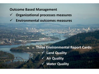
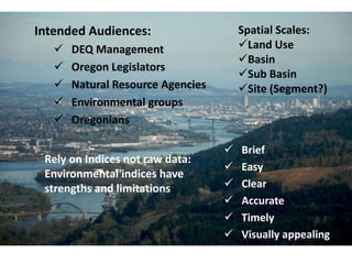
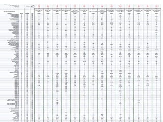
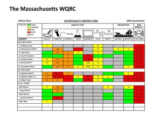
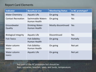
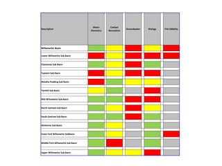
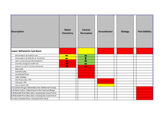
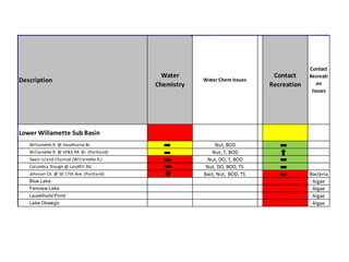
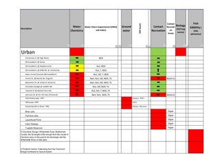
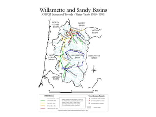
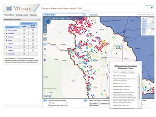
The document discusses a water quality report card for Oregon. It outlines several elements that could be included in the report card such as water chemistry, contact recreation, groundwater quality, biology, and fish consumption indicators. It provides examples of data sources and spatial scales. Tables show example data and issues for the Lower Willamette Sub Basin. The report card aims to assess and communicate water quality to various audiences in an easy to understand format.
The Planet Guardians project measured water quality in the Sabana Llana stream. They used Vernier sensors to test parameters like temperature, pH, dissolved oxygen, conductivity, turbidity, and ion concentrations. Temperature, pH, and dissolved oxygen levels were within normal ranges for aquatic life. However, turbidity was high, and concentrations of ammonium, nitrates, and chlorides exceeded safe levels. This suggests the stream is polluted by contaminants like agricultural runoff and other discharges. While some physical characteristics were acceptable, the chemical analysis revealed pollution that could harm the stream's ecology if not addressed.
The document discusses environmental flow assessments that were conducted in the Lower Yellow River, including selecting study sites, identifying key river assets, developing conceptual models linking flows to asset health, setting ecological objectives, hydraulic modeling, and establishing recommended flow rules to balance environmental and other needs. Field surveys, workshops, and literature reviews informed the methodology and recommendations.
This document provides information about the Water Quality 2010 conference proceedings. The conference was organized by water@leeds, the water research center at the University of Leeds, and was held on June 23-24, 2010 at the Weetwood Hall Hotel in Leeds, UK. It included keynote speakers, presentations on various topics related to water quality management, policy, research, treatment and monitoring. The proceedings document the program, presentations and posters from the conference.
The document summarizes a student project called Water Cops PR CL that aims to study local watersheds. The project involves students using tools like Vernier LabQuest sensors to measure water quality parameters like turbidity, conductivity, alkalinity, pH, temperature, and dissolved oxygen at sites along the Rio Piedras river. Students will analyze their findings, produce written articles and maps using software, and investigate how human activities impact watershed hydrology and land usage affects plant and animal communities near the river. They will assess water quality through physical, chemical and biological measurements and evaluations.
1) The document discusses the status of surface water and groundwater in Ireland according to the Water Framework Directive. It provides interim status assessments showing the percentage of water bodies with high, good, moderate, poor, or bad ecological status.
2) Wastewater treatment plants, agriculture, forestry, and urban areas are cited as the main causes of surface water bodies having "less than good" status. For groundwater, agriculture is contributing to poor chemical status in many areas.
3) Key issues discussed include nitrogen and phosphates in water impacting seaweed blooms, groundwater as both an input to and pathway for surface waters, and groundwater-dependent ecosystems.
This document discusses studies of the Bolin and Morgan Creek watersheds in North Carolina. It outlines the goals of assessing stream health, identifying water quality and habitat stressors, and finding sources of pollution. Biological and water quality sampling methods are described, including the collection of insects, fish, algae, and water samples. The results found some concerns like low dissolved oxygen, metals like copper, and pesticides, but nutrients were generally okay. Assessments also identified needs like erosion control and riparian buffer restoration. Ongoing monitoring is recommended to track long term trends in stream health.
The document discusses the environmental impacts of high volume hydraulic fracturing, or fracking, for natural gas in Pennsylvania. It notes that HVHF uses much larger volumes of water and chemical additives compared to traditional fracking methods. Regulatory loopholes and inadequate oversight of water withdrawals, wastewater disposal, and facility siting have led to concerns about impacts to water resources, habitat fragmentation, and threats to public water supplies and aquatic ecosystems. The organization discussed, Stewards of the Lower Susquehanna, is working to educate the public and advocate for stronger regulations and enforcement to better protect the environment.
This document analyzes the seasonal bioaccumulation of copper in guppies (Poecilia reticulata) collected from the Butuanon River in Metro Cebu, Philippines. Water, sediment, and fish samples were collected from four stations along the river in both the dry and wet seasons. Copper levels in the water were within acceptable standards but exceeded limits in some sediment samples. Guppies from one station exceeded safe copper levels for fish. The bioaccumulation factor, which measures how much copper accumulates in fish from water, was higher in the wet season. The octanol-water partition coefficients, which indicate the form and levels of copper, varied between stations. Traces of thiodiazole were also
Desalination of the Sea Around Us, Part ICarol Reeb
This is a talk on seawater desalination I gave in Seaside California on October 19th, 2010. It is divided in two parts.
Part I contains information on seawater desalination and how the process can impact the marine environment.
Part II provides specific examples of how brine discharged from these plants can affect species, especially eggs and developing young.
It ends with an illustration of how water recycling could be a better long-term solution to our looming water crisis on the Monterey Peninsula and in the State of California.
This document presents an abstract for a thesis about the interaction between built and natural systems. As populations grow and concentrate in cities, these interactions are becoming more important. The thesis will immerse occupants in a series of built typologies expressing different levels of integration with natural ecologies. The St. Johns River system and Jacksonville, FL will serve as the natural and built contexts. A mixed-use development anchored by an ecological center will exhibit and research the river basin through typologies ranging from closed research biomes to open natural areas. The goal is to condense and experience the hydrological and ecological connections of the river system from freshwater headwaters to the brackish mouth.
TERATOLOGICAL DIATOM DEFORMITIES IN THE PERIPHYTON OF COLORADO ALPINE STREAMS...Ellie Muhr
This document is a thesis submitted by Ellie Muhr to the University of Colorado at Boulder analyzing teratological diatom deformities in alpine streams affected by acid mine drainage (AMD) in Colorado. The thesis aims to study diatoms collected from the periphyton of two AMD-contaminated streams, Peru Creek and St. Kevin's Gulch, and compare them to a pristine reference stream, Deer Creek. In St. Kevin's Gulch, high frequencies of asymmetrical abnormalities and bent valves were observed in the diatom genus Eunotia exigua, indicating potential teratological deformities linked to AMD contamination. The results further the need for developing an index to assess AMD contamination
Scientific Article Rio Piedras & Guaralcanal stream vol3papersh21
The Water Cops PR CL project involves students exploring their local watershed to understand water flow and how human activities impact water quality. Students collected water quality data from two sites on the Rio Piedras river using sensors to measure temperature, dissolved oxygen, turbidity, conductivity, pH and stream flow. Analysis showed normal readings except for higher than expected turbidity and conductivity at one site. A second site on the Guaralcanal stream had elevated levels of nitrates and ammonium, likely due to agricultural runoff polluting the water. Creating a watershed model with GIS software allowed for spatial analysis of the data and identification of population densities near sampling areas.
Assessment of Heavy Metals in Philippine Green Mussels Perna viridis and Leve...IJAEMSJORNAL
There have been no published data reports up to date regarding the heavy metal concentration on both the green mussels Perna viridis and total coliform level from Manila bay adjacent to Sipac Almacen, Navotas Philippines. Hence, this study aimed to provide a recent status on the concentration of heavy metals (Cd, Cr, Pb, and Hg) in the muscular tissues of P. viridis and coliform level from Manila Bay, Philippines. Specimen samples were collected on February 22, 2019, almost 1000 m away from the coastline, immediately brought to the laboratory, morphologically identified, dissected for muscles, and subjected to heavy metal and coliform testing. Tissue samples of P. viridis and sediment samples from Manila bay were subjected to Flame-AAS (atomic absorption spectrophotometry) method for detecting and quantifying heavy metals such as total cadmium (Cd), total chromium (Cr), and total lead (Pb) while the analysis of total mercury (Hg) were done using the Cold Vapor-AAS method. With reference to a previous study, the sediment and P. viridis from this study obtained a lower total Cd, Cr, and total Pb while total Hg concentration is below the resulting limit. The water sample was subjected to multiple fermentation technique to identify the coliform level which shows a high-level result of 1.6 X 10³ that is far from the 3000 value set by DAO 2016-08 for SB water body category. The physicochemical analyses on the bay show no value of ecological concern. P. viridis in Manila Bay did not exhibit any serious deformities
The document summarizes a workshop on stormwater management in the Coastal Plain held in Virginia Beach. It discusses the unique challenges of managing stormwater in flat, low-lying coastal areas with shallow water tables. These include highly altered drainage, connections between stormwater practices and estuaries, and seasonal heavy rainfall events. The workshop covered regulatory requirements, low impact development techniques, and tools to help communities meet water quality and quantity goals in Coastal Plain environments.
The document discusses healthy and unhealthy aquatic environments. A healthy environment is abundant with macroinvertebrates, has healthy plant life, trees nearby, well-aerated flowing water with many riffles and algae on rocks. An unhealthy environment has polluted water, debris left by humans, an iridescent film on the surface, and little life besides pollution-tolerant organisms. It also discusses preserving stream health through maintaining buffer zones, planting shrubs to prevent erosion, not dumping in streams, helping clean trash, not changing the stream's path, and keeping septic systems in good condition.
The document discusses the Murray-Darling Basin Plan, which aims to balance environmental and consumptive water needs in the basin. It notes that significant development has led to overallocation of water, degrading the environment. The Basin Plan seeks to set sustainable diversion limits and return more water to the environment through investments while minimizing socioeconomic impacts. It describes the process of determining environmental water needs based on key assets and functions. Opportunities and constraints to implementation are also discussed.
This presentation was given by Sue OHalloran of University of Wisconsin, Superior - Extension at the September 17th meeting of the Lake Superior Binational Forum. Amy Elliot of the Lake Superior Research Institute co-authored this presentation on Lake Superior Citizen Environmental Monitoring.
The document discusses China's National River Health Monitoring and Restoration Program. It outlines challenges facing China's rivers, including water pollution, soil erosion, and floods. It then describes the national program to regularly assess river health, establish standards and methods, conduct monitoring, and produce biennial reports. The program aims to improve river water quality, hydrology, habitats, ecology, and functions. It will assess pilot rivers from 2010-2013 and establish a framework for defining and measuring healthy rivers.
Water Wednesday - Murray Darling Basin Plan: Striking the right balance
The Water Research Centre in conjunction with Australian Water Association SA Branch presented Water Wednesday on 29 February 2012.
This special joint Water Wednesday forum featured a presentation from Professor Barry Hart, an independent member of the Murray Darling Basin Authority, on the Draft Basin Plan which is currently out for public review.
1) The Yellow River Environmental Flow Management Program established in 1998 aimed to restore continuous river flow, improve water quality, and protect riparian wetlands through legal measures, public consultation, water allocation reforms, and technical measures like artificial floods and sediment flushing.
2) The program succeeded in restoring continuous river flow after 1997 when it dried up for 226 days, and improved water quality through pollution reduction efforts. It also helped recover riparian wetlands that depend on freshwater supply.
3) Managing environmental flows aims to balance social benefits from flood control, water supply, and other river uses with ecological benefits like protecting habitats and wetland vegetation. The River Health Index is used as a tool to help achieve this
Strategic Aquatic Habitat Conservation Opportunities for Minnesota Lakes discusses fish habitat in lakes, including physical structures like vegetation and woody habitat, as well as water quality properties. The primary disturbance drivers are shoreline development and watershed disturbances from urbanization and agriculture. The document analyzes how these disturbances impact habitat conditions and proposes allocating resources to protection and restoration efforts to reduce risks to water quality and fish populations.
This document discusses mercury levels in Utah, focusing on levels found in fish and waterfowl from Great Salt Lake and other water bodies. It notes that mercury is a neurotoxin that poses risks, especially to pregnant women, nursing mothers, and young children. Studies have found elevated mercury levels in fish from certain reservoirs, leading to fish consumption advisories. Wildlife studies found elevated mercury in waterfowl from Great Salt Lake, particularly in northern shovelers. Food web studies traced mercury in the lake through brine shrimp, brine flies, and periphyton up to birds.
The document discusses the need for a statewide lake water level monitoring network in Wisconsin to track long-term trends, establish baseline conditions, and increase understanding of lake hydrology. It proposes selecting a core set of lakes for monitoring and establishing standardized protocols. Challenges include maintaining consistent datums over time and interpreting historical water level data. Next steps are to choose index lakes, identify observers, install gauges, and develop data collection and reporting procedures. The network aims to coordinate water level monitoring efforts and facilitate involvement of citizen scientist volunteers.
Toxicological Effect of Effluents from Indomie Plc on Some Biochemical Parame...IOSR Journals
1) The study examined the effect of effluent from an Indomie food company on biochemical parameters of fish in the New Calabar River in Nigeria.
2) Fish and water samples were collected from four stations - a non-point control station, the effluent discharge point, and stations 10m upstream and downstream.
3) Analysis found higher levels of potassium, sodium, urea and creatinine in the blood, gills, liver and muscles of fish sampled closest to the discharge point, indicating pollution has the greatest effect near the source of the effluent.
The document discusses shallow lake ecology, focusing on Crooked Lake in Anoka County, Minnesota. It provides an overview of physical properties, biological characteristics, water quality drivers, and diagnostic tools for shallow lakes. Key points include:
1) Shallow lakes are defined as having a maximum depth of 15 feet or less, or with 80% of the area shallow enough to support aquatic plants.
2) Water quality in shallow lakes is driven by nutrients like phosphorus, with high phosphorus leading to turbid conditions and low phosphorus resulting in clear water.
3) Management strategies aim to switch shallow lakes from a turbid state to a clear water state and include external nutrient control, biomanipulation of
Metrohm is the global market leader in titration and ion analysis equipment. They manufacture exclusively in Switzerland and provide comprehensive support services to water laboratories, including over 1300 free applications. Metrohm works with customers to develop customized solutions for water analysis to ensure compliance with various regulatory standards around parameters such as pH, conductivity, anions, cations and metals.
The Planet Guardians project measured various water quality parameters in the Sabana Llana stream, including temperature, pH, conductivity, dissolved oxygen, turbidity, stream flow, and ion concentrations. While most measurements were within normal or acceptable levels, some exceeded standards. Dissolved oxygen and turbidity were higher than ideal, and ammonium and nitrate levels were above drinking water standards. Overall, the results indicate the stream is overloaded with pollutants that are stressing the ecosystem. The project aims to identify pollution sources and develop solutions to improve water quality.
This document provides an overview of chemical water quality assessment and sampling techniques. It discusses key concepts like the Clean Water Act's goal of maintaining chemical, physical and biological water integrity. Key chemical water quality parameters that can be sampled in the field are discussed, such as temperature, turbidity, dissolved oxygen, pH, alkalinity and nutrients. The document also covers sampling locations, preservation methods, field safety, and calibration of sampling equipment.
The document summarizes the role and work of Environment and Resource Sciences (ERS) which provides scientific support to the Department of Environment and Resource Management (DERM) and Queensland Government. ERS conducts applied science using innovative techniques across areas such as water quality, ecosystems, coal seam gas impacts, vegetation management, air quality, and more. Key current projects include monitoring floods/cyclones, land management impacts on the Great Barrier Reef, remote sensing of vegetation, interactions of land condition and water quality, and monitoring of iconic species. Future work focuses on developing evidence for policy using integrated and innovative approaches across landscapes.
For awareness about treated water purity & quality – Toxicity free treated water for reuse
SCOPE : Toxicity free treated water @ all WWTP Operations, Reuse & Verification
We are facing treated water quality crisis. Treated non complains effluent discharge contaminated land and eco system. It is directly affected to our food production and human health and well being.
A healthier human future needs urgent action for smart sustained water reuse management. The one of the important management tool is ETV (Effluent Toxicity Verification) System
The document discusses monitoring and evaluation of a rural water supply and sanitation project in accordance with government policies. It outlines the project's objectives of improving sanitation, hygiene practices, and institutional capacity for water supply and sanitation. The document describes the methodology for developing a monitoring program, including identifying water quality issues, establishing a monitoring network, and evaluating the project's effectiveness. It also lists contaminants to be analyzed during water quality sampling and assessment.
Water quality depends on various physical, chemical, and biological parameters. Key parameters for assessing water quality for human consumption include pH, dissolved oxygen, biochemical oxygen demand, temperature, conductivity, total dissolved solids, and turbidity. Monitoring these parameters provides information about water contamination levels and suitability for drinking and environmental uses.
The document discusses progress and challenges in restoring the Willamette River floodplain over the past 15 years. It outlines four key efforts that have influenced restoration: the Willamette Basin Task Force (1997), which focused on governance, funding, monitoring and data, and outreach; the Willamette Restoration Strategy (2001), which identified focus areas, actions and measures; the Willamette River Basin Planning Atlas (2002), which modeled trajectories of conservation and development; and the Willamette Special Investment Partnership (2008), which established common ecological priorities and an informal implementation network. Enduring challenges include governance, sustained funding, comprehensive data management, and effective outreach.
The document discusses tribal resources and land conservation by the Confederated Tribes of Grand Ronde. It provides historical context on tribal land management practices prior to treaty signing, including active landscape management to encourage resource production and an extensive trade network. It presents challenges to conservation like invasive species and habitat degradation. The tribal vision involves connection to land from time immemorial and viewing natural resources as cultural. Solutions discussed include outreach, education, long-term conservation and restoration partnerships. Examples provided are Rattlesnake Butte and Chahalpam Wildlife Area conservation projects.
The Willamette Biological Opinion Implementation document provides an update on progress implementing actions from the 2008 biological opinions on operations of the 13-dam Willamette Project. Key actions include improving upstream and downstream fish passage, water quality including temperature control and total dissolved gas, instream flows, hatchery improvements, and habitat restoration. Updates are given on specific projects and studies underway on the McKenzie, Middle Fork Willamette, North Santiam, and South Santiam rivers to address fish passage and water quality requirements for ESA-listed salmon and steelhead.
This document summarizes recovery efforts for Upper Willamette River Chinook salmon and steelhead. It discusses the key challenges facing these species, including blocked passage, changed water temperatures, pre-spawning mortality, and reduced habitat complexity and water quality. The recovery efforts focus on protecting and increasing diverse habitat types, off-channel areas, shallow water habitat, floodplain connectivity and water quality through partnerships. Specific actions include implementing the Willamette Project Biological Opinion, coordinated research, hatchery and harvest reform, and prioritizing actions to reduce pre-spawning mortality, improve passage, rearing and migration conditions, and monitor progress.
The Willamette Wildlife Mitigation Program is a $157 million agreement signed in 2010 to conserve and restore wildlife habitat in the Willamette Basin over 15 years. It will acquire 16,880 acres of land by 2025 for the Oregon Department of Fish and Wildlife. The program established an advisory group and defines how projects can provide dual benefits for fish and wildlife. It is consistent with regional conservation plans and objectives. In 2013, the program recommended 2621 acres for purchase, with 14 projects totaling that amount, of which 6 provide dual credits.
The document summarizes the Confederated Tribes of Warm Springs Reservation of Oregon's (CTWSRO) experience acquiring and managing lands for mitigation through the Bonneville Power Administration's Willamette Basin Wildlife Mitigation Program. Specifically, it discusses four areas totaling over 35,000 acres that have been acquired and are managed by CTWSRO for wildlife mitigation. It outlines CTWSRO's mission and goals in partnering with BPA on the mitigation program to acquire ecologically beneficial lands and provide cultural resources and harvest opportunities. Upcoming plans include continuing to build partnerships to actively pursue additional properties that would benefit the mitigation program.
TRaCK research is providing science to support sustainable management of northern Australia's tropical rivers and estuaries. Three projects are modeling future development scenarios over 30 years, finding that 5% agriculture increases Indigenous income by 6% but reduces fish habitat and harvest by 11%, while 5% government investment increases Indigenous income 45% while reducing these impacts. TRaCK2 will focus on interdisciplinary problem-solving projects co-developed with stakeholders.
Large scale river restoration programs require bringing science into both planning and implementation. Two successful projects, the Kissimmee River Restoration and Healthy Waterways Initiative in Australia, established rigorous monitoring programs to evaluate outcomes. The California Delta faces challenges of balancing water exports and habitat restoration, requiring an adaptive approach incorporating the best available science. Institutional challenges to large river restoration include uncertainty, the transition from planning to action, effective communication, and integrating synthesized data.
This document lists the names of 14 individuals and 3 organizations that were dedicated members of Team Willamette. The individuals include William J. Finley, Fred Merryfield, R.E. Dimick, Tom McCall, Robert Straub, Gail Achterman, Jim Sedell, Peter Kenagy, Pam Wiley, Dave Hulse, and Ken Bierly. The 3 organizations are Meyer Memorial Trust, University of Oregon, and Oregon Watershed Enhancement Board.
Presented at Within Our Reach 2012 by:
CARL SHRECK - Professor and Leader, Oregon Cooperative Fishery Research Unit, Oregon Dept. of Fish & Wildlife
GABE SCHEOSHIPS - Columbia River Intertribal Fish Commission
CYNDI BAKER - Fisheries Biologist, Confederated Tribes of the Warm Springs
LANCE WYSS - Faculty Research Assistant, Willamette River Basin Lamprey Project, Oregon State University
BRIAN McILRAITH - Pacific Lamprey Project Lead, Columbia River Inter-Tribal Fish Commission
This document summarizes a study on Pacific lamprey in the Willamette River basin. It discusses the project objectives of determining lamprey migration patterns, overwintering locations, and use of tributaries for spawning. It provides data on the number of lamprey tagged from 2008-2012 and the number of fixed monitoring sites. It also lists additional future study objectives such as determining if lamprey spawn in the mainstem river, quantifying juvenile rearing habitat, and incorporating lamprey needs into floodplain restoration.
This document summarizes key uncertainties and context around Pacific lamprey biology. It identifies several areas of critical uncertainty, including lamprey biology, population structure, habitat use and requirements, ecology, monitoring methods, and conservation and management approaches. The document also notes that while there are many uncertainties, lampreys provide an opportunity to explore scientific questions at multiple scales, from basic biology to population trends to integrating mechanisms with patterns. Overall, the document outlines open questions and a need for further lamprey research and monitoring to address uncertainties.
The document discusses the development of environmental report cards to communicate information about ecosystem health. It provides examples of existing report cards for the Chesapeake Bay and Great Barrier Reef. A five step process is outlined for creating report cards: 1) create a conceptual framework, 2) choose indicators, 3) define thresholds, 4) calculate scores, and 5) communicate results. Report cards work by leveraging peer pressure and synthesizing large amounts of data into an easily understandable format based on a common experience with educational report cards.
The Natural Areas Program has grown from managing zero acres to over 16,000 acres in 20 years through two bond measures that provided $363 million. While land acquisition was relatively straightforward, ongoing ecological and land management challenges require expertise in areas like invasive species control, hydrology, forestry, monitoring, and more. Securing long-term funding for management has been difficult, with bond funds only covering acquisition and limited annual budgets restricting work. A permanent funding source, even at a modest level, is needed to better care for the natural areas portfolio.
The document discusses the Oregon Parks and Recreation Department's natural resource stewardship program. It outlines the department's mission to protect natural, scenic, cultural, historic and recreational sites. It also discusses some of the program's strategies, challenges, and solutions, including the need for partnerships, large-scale weed surveys, and addressing funding issues. The final section covers additional uncertainties like dam operations, climate change, and potential new invasive species.
This document discusses a twinning partnership program between watershed groups in the Siuslaw Basin of Oregon and regions of the Russian Far East aimed at salmon habitat restoration and community engagement. It provides an overview of exchanges between 2004-2012, including student blog projects, workshops on planning and restoration, and establishing public salmon councils in Russia. It outlines successes of the program as well as challenges such as language/cultural barriers, government cooperation, and funding. The document advises on carefully selecting twinning partners by considering similarities/differences in needs, assets, and levels of experience.
The document discusses establishing "twinning" partnerships between the Willamette river restoration groups and other groups facing similar challenges. It proposes that the Willamette groups offer their expertise to help other groups restore rivers efficiently and sustainably. Criteria for compatible twinning partnerships include a personal relationship, high motivation levels in the other group, matching skills, and public and financial support. The document outlines what is needed to propose such a partnership, including a business plan and Memorandum of Understanding, and notes assistance that can be provided by the International RiverFoundation.
The document presents a 30-year vision for open space along the Willamette River between Eugene and Springfield, Oregon. It identifies opportunities for river-oriented mixed-use development and redevelopment of industrial sites, with an emphasis on ecological design and public access to the river. Specific opportunity areas mentioned include the EWEB site in Eugene and the Glenwood Refinement Plan area in Springfield.
Milwaukie Riverfront Park is a proposed park along the Willamette River in Milwaukie, Oregon. The city adopted a downtown riverfront plan in 2000 and selected a designer in 2006. Since then, the city has submitted land use and permit applications and received local approvals, but still needs to address access from McLoughlin Boulevard, complete permitting, and secure funding to move forward with the park project.
The document summarizes an upcoming 90-minute breakout session discussing river health in cities along the Willamette River. The session will include a quick introduction, a 20-30 minute panel featuring representatives from three cities, a 50 minute Q&A and discussion period, and a 5 minute wrap-up. The panelists will discuss how cities are improving river health, key restoration challenges, and messages for the wider community about city-related opportunities and limitations regarding balancing economic, development, and natural resource needs.
2. Outcome Based Management
Organizational processes measures
Environmental outcomes measures
Three Environmental Report Cards:
Land Quality
Air Quality
Water Quality
3. Intended Audiences: Spatial Scales:
DEQ Management Land Use
Basin
Oregon Legislators
Sub Basin
Natural Resource Agencies Site (Segment?)
Environmental groups
Oregonians
Brief
Rely on Indices not raw data:
Easy
Environmental indices have
strengths and limitations Clear
Accurate
Timely
Visually appealing
6. Report Card Elements
Indicator Beneficial Use Monitoring Status In RC prototype?
Water Chemistry Aquatic Life On going Yes
Contact Recreation Swimmable Waters- On going Yes
Human Health
Groundwater Drinking Water- Mostly discontinued Yes
Quality Use
Beneficial
Aquatic Life Use
Indicator
Human Health
Water Quality
Data Source
OWQI, Ambient Monitoring Network
Water body
Larger Rivers
Contact Recreation Use Human Health Bacteria (Amb Mon), Harmful Algal Larger Rivers, popular lakes
Blooms (OHA)
Biological Integrity
Drinking water Aquatic Life
Human Health Discontinued
Groundwater studies Yes
Groundwater
Aquatic Life Use Biological Integrity Macroinvertebrate community scores Mostly wadeable streams but
from Oregon Plan and other some larger rivers
Fish Toxics Fish Edibility- On going
monitoring
Partially
Fish Consumption Human Health
Human Health OHA fish consumption advisories Lakes and Rivers
(Fish Tissue)
DEQ Toxics Monitoring data Rivers
Water column Fish Edibility- On going Not yet
toxics
Fish Consumption Human Health
Human Health DEQ Toxics Monitoring Data Rivers
(water column)
Water column
Aquatic Life Use Aquatic Life and
Toxics water
sediment
On going
DEQ Toxics Monitoring Data Not yet
Rivers
toxics
Not part of the RC prototype but should be:
Bays, estuaries, beaches, lakes, wet lands, temperature.
7. Water Contact
Description Groundwater Biology Fish Edibility
Chemistry Recreation
Willamette Basin 86 0.83
Lower Willamette Sub Basin 65 0.59
Clackamas Sub Basin 93 0.96
Tualatin Sub Basin
55 1
Molalla-Pudding Sub Basin 71 0.85
Yamhill Sub Basin 1
81
Mid Willamette Sub Basin
88 1
North Santiam Sub Basin 94 0.89
South Santiam Sub Basin
1
McKenzie Sub Basin
93 1
Coast Fork Willamette SubBasin 1
Middle Fork Willamette Sub Basin 1.1
Upper Willamette Sub Basin 1
87
8. Water Contact
Description Groundwater Biology Fish Edibility
Chemistry Recreation
Lower Willamette Sub Basin 65 0.59
Willamette R. @ Hawthorne Br. Fair Good
Willamette R. @ SP&S RR Br. (Portland) Fair Good
Swan Island Channel (Willamette R.) Poor Good
Columbia Slough @ Landfill Rd. Very Poor Good
Johnson Ck. @ SE 17th Ave. (Portland) Very Poor Poor
Blue Lake
Fairview Lake
Laurelhurst Pond
Lake Oswego
Mid-Multnomah 1995 3
Milwaukie 1989 3
Sauvie Island 1985 2
X Columbia Slough: Willamette Zone, Multnomah County, PCBs
the full length of the slough from the mouth of Fairview Lake
X Portland Harbor: Extending from the Freemont Bridge PCBs
northward to Sauvie Island
X Willamette River Main stem, including the Coast Fork to Mercury and PCBs
Cottage Grove Reservoir.: The mainstem of the Willamette
X Willamette River Main stem, including the Coast Fork to Mercury and PCBs
Cottage Grove Reservoir.: The mainstemZone Willamette
X Lower Columbia River: Columbia River of the PCBs
9. Contact
Water Contact Recreati
Description Water Chem Issues
on
Chemistry Recreation
Issues
Lower Willamette Sub Basin 65
Willamette R. @ Hawthorne Br. Fair Nut, BOD Good
Willamette R. @ SP&S RR Br. (Portland) Fair Nut, T, BOD Good
Swan Island Channel (Willamette R.) Poor Nut, DO, T, BOD Good
Columbia Slough @ Landfill Rd. Very Poor Nut, DO, BOD, TS Good
Johnson Ck. @ SE 17th Ave. (Portland) Very Poor Bact, Nut, BOD, TS Poor Bacteria
Blue Lake Algae
Fairview Lake Algae
Laurelhurst Pond Algae
Lake Oswego Algae
10. Contact Fish
GW Issues
Water Water Chem Impairments (OWQI Ground Contact Recreati
Biology
Description (O/E bug
Edibility (
Chemistry sub index) water Recreation on OHA
Issues scores) advisories)
0.80
Urban 0.20
Clackamas R. @ High Rocks Excellent BOD Good
Willamette R. @ Salem Excellent Good
Willamette R. @ Hawthorne Br. Fair Nut, BOD Good
Willamette R. @ SP&S RR Br. (Portland) Fair Nut, T, BOD Good
Swan Island Channel (Willamette R.) Poor Nut, DO, T, BOD Good
Fanno Ck. @ Bonita Rd. (Tigard) Very Poor Bact, Nut, DO, BOD, TS Poor Bacteria
Beaverton Ck. @ 216th St. (Orenco) Very Poor Bact, Nut, DO, BOD, TS Good
Columbia Slough @ Landfill Rd. Very Poor Nut, DO, BOD, TS Good
Tualatin R. @ Boones Ferry Rd. Very Poor Nut, DO, T, BOD, TS Good
Johnson Ck. @ SE 17th Ave. (Portland) Very Poor Bact, Nut, BOD, TS Poor Bacteria
Mid-Multnomah 1995 3 Nitrates, VOCs
Milwaukie 1989 3 VOCs
SantaClara/River Road 1980 4 Nitrates, Bacteria
Blue Lake Algae
Fairview Lake Algae
Laurelhurst Pond Algae
Lake Oswego Algae
Tualatin Reservoir Algae
X Columbia Slough: Willamette Zone, Multnomah
County, the full length of the slough from the mouth of
Fairview Lake on the east to its discharge into the
Willamette River on the west PCBs
X Portland Harbor: Extending from the Freemont
Bridge northward to Sauvie Island PCBs