Modelling large scale evacuation scenarios to build safer cities
•
2 likes•308 views

Technical paper co-authored by alumnus Pablo Alvarez of AECOM. First published in 'Transport Professional' magazine (copyright CIHT). www.its.leeds.ac.uk/alumni/profiles/countries/spain/pablo-alvarez Reproduced with permission.

Recommended
Recommended
More Related Content
Similar to Modelling large scale evacuation scenarios to build safer cities
Similar to Modelling large scale evacuation scenarios to build safer cities (20)
More from Institute for Transport Studies (ITS)
More from Institute for Transport Studies (ITS) (20)
Recently uploaded
Recently uploaded (20)
Modelling large scale evacuation scenarios to build safer cities
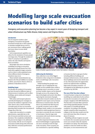
- 1. Transportation Professional September 201616 Technical Paper Introduction Use of computer models to plan emergency evacuations has greatly increased recently due to their capacity to simulate multiple factors such as pre-movement times, walking speeds and route choice in more detail than before. Such computational capability now allows for the simulation of many people over large areas. Through the analysis of ‘what if’ scenarios it is possible to reduce the risk of deaths and injuries from an incident. Advantages that micro simulation modelling can bring to evacuation planning are already known but it has rarely been applied to larger scenarios such as cities or other populated areas where different kinds of emergency situations may occur. These include natural disasters (eg floods in the UK and wildfires in Canada in 2016), acts of terror (Paris in 2015) or pollution (Fukushima in 2011). Modelling larger For decades the analysis of evacuation has been focused on different types of infrastructures in isolation such as office buildings, sports stadia and transport interchanges. With urban and transport planners currently developing new strategies to increase the resilience capacities of our cities, there is also a need to develop a broader point of view on evacuation planning which includes the evacuation of a large area of the city. Large scale evacuation is a complex phenomenon, especially due to the role of evacuees and their actions and decisions. The complexity embedded in this process has begun to be addressed only recently, with the use of computer evacuation models along with enhanced data collection on human performance and movement. Modelling large scale evacuation scenarios to build safer cities Emergency and evacuation planning has become a key aspect in recent years of designing transport and urban infrastructure say Pablo Alvarez, Andy Leeson and Virginia Alonso. Crowds of football supporters leaving St James’ Park stadium in Newcastle Addressing the limitations Data collection is one of the biggest limitations when using micro simulation tools to model large scale evacuation scenarios. Understanding how people move through a city or analysing the way people use the available space within a shopping centre is necessary to create accurate models. Inputs can be obtained through surveys or by using new big data technologies and sensors that allow capturing the movement of people. Data from research studies can also be applied for some inputs such as human behaviours or reaction times. But this data is very limited and often focuses on specific scenarios (such as office buildings, hotels, stadia) or on evacuation scenarios in which people have hours or even days to evacuate the area (tornados or hurricanes). Data for large scale evacuations with much shorter warning periods is even scarcer. Another important limitation is the lack of methodologies to appropriately use micro simulation tools for large scale evacuation. These scenarios are not constrained to a specific building or location but their scope goes further including different buildings and transport infrastructures, streets around those buildings and even the whole town or city. This means that new approaches need to be explored when modelling large scale evacuation scenarios – as investigated on the following two projects carried out by AECOM. The case of the Yesa dam collapse A research project using micro simulation modelling was undertaken by the authors to study the evacuation of a small town in Spain, Sangüesa with 5000 inhabitants. The Yesa dam is located 10km upstream and is being expanded despite concerns with respect to unstable geological conditions. According to the flooding models created by other researchers a collapse in the Yesa dam would cover the town with more than 20m of water in about 23 minutes. Modelling software (Legion) was used to simulate the evacuation process for the worst case scenario when the majority of residents are asleep. The information needed to create the model was taken from plans, on site measurements and SteveDrew–PA
- 2. Transportation Professional September 2016 17 census data in order to realistically represent each household and its demand. A literature review process and a stated preference survey were used to gain insights into behavioural aspects during the emergency: such as what people would do at home before leaving, which route they would use and whether they would use a car. A new methodology was created that consists of the use of sub models to represent different levels of the evacuation process: actions taking place in the house, people leaving the building and evacuation in the streets. All the sub models are inter dependent and inter connected (multi scale models) meaning that the outputs from one sub model are the inputs for the next one. This allowed for a realistic and flexible way to simulate the evacuation process. The results indicated that people would need between 33 to 44 minutes to evacuate the whole town to a safe place and the study will be useful to improve the evacuation plan in the town. Newcastle city centre evacuation pilot study A second study undertaken recently has been to develop a model capable of predicting pedestrian movements in a major city centre. Using a pedestrian modelling software (from INCONTROL), an evacuation scenario centred on Newcastle’s intu Eldon Square Shopping Centre has been created as the ‘base case’. Footfall data indicates that on a Saturday afternoon around 6000 people may be in the shopping centre’s circulatory area and smaller retail units – ie the areas requiring use of the main fire escape routes. The base model confirmed that clearing the centre in sufficient time is not an issue but does rely on egress routes being uncluttered and free flowing. What happens if these become restricted in any way? As the peak time period for Eldon Square coincides with the final whistle of Saturday afternoon football games ending at nearby St James’ Park a second scenario was implemented adding another event: the exiting of St James 10 minutes before the evacuation event in Eldon Square – by which time stadium goers would have reached the city centre. The stadium has a capacity of 52,405 spectators, most of whom typically make straight for the pubs, cafes or public transport hubs in the city centre, with streets around Eldon Square often becoming highly congested. When the model was run with these additional spectators there were notable impacts on egress times from the shopping centre and the immediate vicinity. The results of this pilot study show that in isolation the shopping centre can evacuate safely. But if another frequently occurring activity such as the post-match emptying of St James’ Park is added capacity issues may ensue in some areas – for example, the evacuation process using Blackett Street exit would take two minutes longer and could be critical in a real emergency. Results like this could help Newcastle City Council to organise special events as well as longer term planning for footpaths and shared space. The future of large scale evacuation Both the Sangüesa project and Newcastle pilot study show that it is possible to study large scale evacuation scenarios realistically through micro simulation, either in isolation or through linking sub models for greater detail and flexibility. Potentially this could lead to extending the study area by adding further sub models such as train/metro stations, schools, hospitals and other areas of the city, as well as modelling vehicles and pedestrians in shared space areas for a truly integrated model. With software developers exploring new capabilities to better represent aspects such as human and group behaviour and with the new big data technologies being in place to build smart cities that allow capturing data in real time, large scale evacuation will be an important part of urban and transport planning in the coming years. The aim is to build resilient and safer cities. Acknowledgement This paper has been peer reviewed by the CIHT Network Management & Operations Panel. Technical Paper Pablo Alvarez is a civil and transport engineer at AECOM within the transport planning department in St Albans. In the last three years he has specialised in strategic modelling, evacuation modelling and big data applied to transport. He also undertakes research in transport modelling and large scale evacuation, with published papers in conference proceedings. Andy Leeson is an associate director at AECOM, leading the pedestrian modelling team in the Newcastle office. Over the last decade he has worked on rail stations, major sporting events and city centre regeneration projects and has worked with industry to investigate better ways to capture and apply data to pedestrian modelling. Virginia Alonso is a fire engineer and evacuation modelling specialist at AECOM within the fire and risk engineering team in London. With a PhD and more than seven years as a researcher at University of Cantabria (Spain) and Imperial College London her expertise is focused on evacuation modelling and human behaviour in fire. Figure 2. A people density map of one of the scenarios from the Newcastle city centre evacuation model. High densities (shown in purple) may occur in some streets if an evacuation in the Eldon Square shopping centre coincides with people leaving St James’ Park stadium Figure 1. A model of one of the scenarios from the Newcastle city centre evacuation model, showing people leaving St James’ Park stadium (left) when, at the same time, an evacuation in the Eldon Square shopping centre is taking place