SlideShare a Scribd company logo
1 of 80
Download to read offline
The Air Quality Benefits of Road Closure
Background
The main subject of the dissertation is how events
such as flooding, engineering works, sporting events
and car free days can impact on the concentration of
pollutants.
The Research will be looking specifically at 2015
Boxing day Floods in York and the Forth Bridge
Closure due to engineering works
Objectives
Analyse and assess the impact of road closure due
to foreseen and unforeseen circumstances has on
the concentration of air pollutants
Evaluate if road closure can provide a good
understanding of the potential air quality benefits
of adopting electric vehicles
Investigate if disruption can result in changing travel
behaviour
Methodology
• DEFRA AURN Monitoring Sites/ LA Monitoring
Sites
• UK Met Office/BADC
• Statistics from TfS Report on the Forth Bridge
• R ‘Openair’ package
Literature Review
‘Carmagendden’-Zhang (2013): Air Quality analysis of
36hr closure of a main highway in LA
The Olympics- Peel (2010), Zhu (2009): Both paper
looked at the air quality effects the hosting of the
Olympics games
Car Free and Pedestrianisation- Madrid, Bristol and
Paris for Car free. Leeds for pedestrian zone
Conclusion and Implications
• Based on evidence of past disruption events road
closure can lead to a 4-5% change in travel
behaviour
• Potential the pollution is dispersed rather than
reduced
• Does something more radical need to be done?
Preliminary Results and Risks
• The Line graphs below show NO2 levels for Fishergate AURN monitoring site (Urban Roadside) and Bootham
AURN monitoring site(Background).
• Following heavy flooding Fishergate was closed between 26/12/15-07/12/16.
• The graphs indicate a 45% reduction of the pollutant compared to the same period the year before.
• Caveat: Short period analysis may lead to distortion of normal trends. This is true of pollution episodes or
storm aftermath
By: Adam Smith Supervisor: Dr James Tate Email: gy11a3s@leeds.ac.uk MSc Transport Planning and the Environment
Suggestions?
Can you suggest any major disruptions/ road closures
across the UK?
Control of reflective cracking in asphalt overlays
Ahmed M. Abed, MSc Transport Planning and Engineering
Institute for Transport Studies. Supervised by Dr. David Rockliff
 Background
Reflective cracking is considered one of the common
defects in asphalt overlays. It can occur as a result of
an existing cracking in the underlying layers. Thus, it
propagates through a hot mix asphalt (HMA) overlays
(Vanelstraete and Francken, 1997).
There are several factors which can play an important
role in term of producing the reflective cracking. For
instance, Traffic loading and environmental conditions
such as temperature and moisture content (Baek et al,
2010).
It could be argued that each one of these factors has
significant impacts on the underlying layers.
Consequently, water can find its way to enter between
the layers and it will lead to further distress. For
example, stripping and a reduction in the bearing
capacity of the road surface layer (Pearson, 2012).
As a result, structural and functional performance will
be affected and it will cause a significant level of
deterioration (Bandaru, 2008).
Objectives
 References
- Vanelstraete, A. and Francken, L. 1997. Prevention of
reflective cracking in pavements. (RILEM, Report 18).
London: E & FN Spon.
- Pearson, D. 2012. Deterioration and maintenance of
pavements. Institution of Civil Engineers (Great Britain).
London: ICE.
- Al-Qadi, I., Scarpas, T. and Loizos, A. 2008. Pavement
cracking: mechanisms, modeling, detection, testing
and case histories. [Online]. Boca Raton: CRC Press.
[Accessed 20 February2016]. Available from: http://0-
www.crcnetbase.com.wam.leeds.ac.uk/isbn/97802038
82191
- Bandaru, R. 2008. Cost Effective Prevention of
Reflective Cracking in Composite pavement. MSc.
Thesis. Louisiana State University. [Online]. [Accessed
22 February 2016]. Available from:
http://www.ltrc.lsu.edu/ltc_09/pdf/Elseifi,%20Mostafa.p
df
- Quasco. 2016. Technical Information. [Online].
[Accessed 15 April 2016]. Available from:
http://www.rubblization.com/technical-
information.html
Reflective Cracking Mechanisms
Methodology
Discussion
                                   
(Al-Qadi, 2008)
 To make a comparison between types of methods
which are used to prevent the reflective cracking.
 To identify types of reflective cracking and its
mechanism, patterns, shapes and crack propagation
stages.
 To evaluate the performance of control methods
such as Geosynthetics, Paving Fabrics, Geogrids,
Rubbilization and Asphaltic Surface Treatment (chip
seal) in term of long term maintenance by identifying
the cost-effective way of each method.
 To examine the relationship between asphalt
overlays thickness and the reflective cracking.
Structural properties of the asphalt overlays
Thickness
Types
Flexible/ Rigid
Identifying contributory factors
Literatures and research review
Control methods
Cost-Effective way Performance
Practical solutions
Causes
Traffic loading Environmental conditions
Crack opening Shear failure Crack opening
Opening Sliding
Tearing
Causes
Traffic loading Environmental conditions
Crack opening Shear failure
Opening
This study will present an optimal
design approach for developing a
microscopic transportation emissions
model (Micro-TEM) by running micro-
simulations using a traffic model and
integrating the results in an emissions
model to an acceptable degree of
accuracy (VISSIM and EnViVer).
This approach can provide
environmental decision makers with
practical guidelines for their decisions
on environmental transport policies
with a specific focus on how to
integrate junction design to regulate
the local air quality.
Since December 1997 each local authority in the UK has been carrying out
a review and assessment of air quality in their area. This involves measuring
air pollution and trying to predict how it will change in the next few years.
The aim of the review is to make sure that the national air quality
objectives will be achieved throughout the UK by the relevant deadlines.
These objectives have been put in place to protect people's health and
the environment.
If a local authority finds any places where the objectives are not likely to be
achieved, it must declare an Air Quality Management Area there. This area
could be just one or two streets, or it could be much bigger.
How will this be achieved ?
 Primary sources of data –
a. Measuring parameters for the existing roundabout (Thornbury Barracks)
b. Site data for validation of microsimulation model
 Secondary sources of data -
a. Classified turn based traffic count from Leeds City Council (LLC)
b. Emission details on the roundabout (for last three years)
c. Extract results for emissions data from well established transport models
What are Air Quality Management Areas?
Why are emissions a concern ?
 ARCADY to determine Capacity and delays at the existing roundabout.
 LINSIG to signalise and record the delays.
 Replacing the intersection with all three designs as mentioned above
 VISSIM to carry out the micro simulation and derive emissions profile and use EnViVer to analyse spatial
distribution and other parameters.
 Hypotheses testing contrasting the three junction choices.
How will this study benefit ?
DATA ANALYSIS
1. The main goal of the study is to improve the local air quality in an urban corridor using a
microsimulation modeling technique
2. To propose a reasonable junction design that is in compliance in meeting local air
quality objectives under high, medium and low flow levels
1. To monetize the data from emissions model for economic and health impacts
1. Can a microsimulation emissions model show the emissions at a single junction ? What will
be its significance w.r.t to the whole network ?
2. Can junction design study with emissions focus, really help the policy makers in taking air
quality decisions ? How much can it benefit them ?
3. Can a single junction be monetized for emissions ? Could future junctions be designed with
a consideration to emissions too ?
Objectives
Questions
ENVIRONMENTAL ASSESSMENT OF JUNCTION DESIGN BASED ON VARIABLE FLOW CONDITIONS
By Ahmer Sadiq (MSc. Transport Planning and Engineering) ¦ Supervisor: Steve Keetley¦ 2nd Reader: Jeremy Shires
A junction design analysis for the Thornbury
Barracks Roundabout to be carried out based on
the indicators obtained from the analysis of
emissions data and efficiency variables.
***For analysis, it would require weighing and
scoring for each indicator as used above.
Key References
1. DEFRA, 2016. Department of Environment, Food and Rural Affairs
2. DMRB, 2016. Volume 11, Section 3. Environmental Assessment
Techniques
3. Gokhle, S., 2001. Impact of traffic on vehicular exhaust emissions
at traffic junctions
4. Ibrahim, W. and Ramli, N., 2002. A case study of mitigating air
pollution emissions at traffic light junctions
5. ELKAFOURY, A., NEGM, A.M., BADY, M.F. and ALY, M.H., VISSIM
Based Microscopic Traffic Emission Prediction Model.
***NOTE
There are
around 470
local
authorities in
the UK, of
which about
200 have
declared
AQMAs for
one or more
pollutants.
Congestion PM,NOX, SOXFuel Consumption (CO, CO2)Capacity
Junction Performance
EnvironmentalEfficiency
Solution Proposal
ANALYSIS OPTIONS
What are the flows conditions ?
High flows – Peak flows
Medium flows – Off Peak flows
Low flows – Flows after evening peak
DATA REQUIREMENTS
Different
approaches
to car
dependence
Physical
Social
Economic
•Shrinking HH sizes.
•Increasing in labour force
participation.
•Changing land-use patterns.
•Changing commuting patterns
•Changing perceptions on travel.
•Increasing purchasing power.
•…
Multiple and complexes reasons.
Attitudes towards modes and travel preferences can
also be decisive factors to determine transport
behaviour and neighbourhood self-selection.
•Study the correlation between
individual mode choice and the
selected land-use variables and
personal attributes.
•Make a global regression model
between mode choice and the
selected land-use variables and
personal attributes for the
respondents of the survey.
•Determine the degree of
correlation between the variables
selected and mode choice using
geographically weighted regression.
Objectives
There is a strong relationship
between the built environment
and travel behaviour.
Therefore policies to tackle car
dependence should focus on
changing transport behaviour by
land use policies and transport
provisions that make car travel
less necessary or less attractive.
.
.
.
.
.
.
.
.
.
Commuting to the University of Leeds; a geographic analysis of car dependence.
•Congestion and its environmental and
economic consequences.
•Pollution (Noise, NOx, Ozone...)
•The decline of public transport
•Health effects caused by the reduction
in active mobility (obesity) and road
safety itself.
•Commercial viability of town centres.
•Frustrated mobility.
•Decrease in urban quality.
The excessive use of private cars is the
source of most urban transport problems. The effects of road transport
emissions are not only local:
Other
74%
Road transport
20%
Other transport
6%
Transport
26%
Global CO2 Emissions
And despite the commitments on reducing GH gasses
emissions, they keep increasing for the transport sector.
Other studies determined that personal characteristics and
socioeconomic factors have the wider influence in travel behaviour.
Attributes like level of income, car-ownership or household
structure are usually considered decisive in this approach.
Research question
Mode share among commuters to
the University of Leeds is influenced
by geography. Specifically I
hypothesise that mode choice is
correlated with density, land-use
mix, accessibility and design of the
trip origins.
Methodology and data
Built environment variables
The LSOAs of the UoL catchment area will be classified by density
(residents and jobs), land-use mix, accessibility to key services and
pedestrian and cycling facilities using ArcGIS.
Density: Census data and
workplace population data.
Land-use mix: An entropy
measure will be created using Arc
GIS.
Data from OS Mastermap “sites”
layer: FunctionThemeValue
containing areas for education,
medical care, bus station, railway
station and industrial.
Accessibility: DfT Journey time
statistics
Travel time to nearest town centre
by PT/Walk.
Pedestrian and cycling facilities:
Length of pathways per hectare
and length of cycle lanes per
hectare.
Data from OS Mastermap and
Leeds Data Mill.
The built environment variables most widely accepted
to have a strong correlation with travel behaviour are:
accessibility, mixed-use, density and design.
Main references
CERVERO, R. & KOCKELMAN, K. 1997. Travel demand and the 3Ds: Density, diversity, and design.
Transportation Research Part D: Transport and Environment, 2, 199-219.
CHAPMAN, L. 2007. Transport and climate change: a review. Journal of Transport Geography,
15, 354-367.
CRANE, R. 2000. The influence of urban form on travel: an interpretive review. Journal of
Planning Literature, 15, 3-23.
EWING, R. & CERVERO, R. 2010. Travel and the Built Environment: A Meta-Analysis. Journal of
the American Planning Association, 76, 265-294.
HOYLE, B. S., KNOWLES, R., INSTITUTE OF BRITISH, G. & ROYAL GEOGRAPHICAL SOCIETY .
TRANSPORT GEOGRAPHY RESEARCH, G. 1998. Modern transport geography, Chichester, Wiley.
HUNECKE, M., HAUSTEIN, S., GRISCHKAT, S. & BÖHLER, S. 2007. Psychological,
sociodemographic, and infrastructural factors as determinants of ecological impact caused by
mobility behavior1. Journal of Environmental Psychology, 27, 277-292.
LUCAS, K., BLUMENBERG, E. & WEINBERGER, R. 2011. Auto motives: understanding car use
behaviours, Bingley, Emerald.
SANTOS, G., BEHRENDT, H. & TEYTELBOYM, A. 2010. Part II: Policy instruments for sustainable
road transport. Research in Transportation Economics, 28, 46-91.
STEAD, D. 2001. Relationships between land use, socioeconomic factors, and travel patterns in
Britain. Environment and Planning B: Planning and Design, 28, 499-528.
Context and background
It is essential to understand the relationship between these
variables and travel behaviour in order to design policies and
land-use strategies that help to deliver more sustainable cities.
Step 1: Add the land-use attributes of the area where the respondents live to the survey dataset and
perform a logistic regression model between mode choice (PT-car binary dependant variable) and the built
environment variables and job position as independent variables.
Data from the university travel survey: Postcode, job position and main mode (car/PT).
Built environment variables data.
The logit regression will be carried out using R.
Step 2: Map the regression residuals and check for spatial patterns.
ArcGIS and R will be used for this step.
Step 3: Make a Geographically Weighted Regression model, map the results and interpret the data.
The regression will be made using R, Gwmodel package or similar.
EVALUATING THE USE OF MOBILE PHONE DATA IN
MOBILITY MODELLING USING A SIMULATED NETWORK
Author: Alex Patrick (MSc Transport Planning) Supervisor: Charisma Choudhury
2. Background :
 Each time a mobile phone is used, the network provider can determine its rough location
by recording which cell tower received the original signal. It is then possible to plot a travel
diary for individual by plotting their phone signal.
Restrictions of Mobile Phone Data:
 Temporal Resolution: A phone only transmits a signal intermittently, and so there is nothing
to suggest that a phone user took a direct path between two signal locations. A long
enough delay between consecutive signals from a user could lead to entire trips missing
from the data.
 Spatial Resolution: i.e. the imprecision in the recorded location. Per Fig 1, even in a busy area
cell towers can be sparse. The cell tower that receives a signal may not even be the nearest.
It is necessary, then, before hoping to draw reliable conclusions from mobile phone-based
mobility data, to examine the extent to which these influences reduce its quality and
accuracy.
1. Research Objectives:
 Determine the extent to
which mobility data derived
from mobile phone usage
records describes real-life travel
patterns.
 Investigate the sensitivity of
mobility data quality to
differences in the spatial and
temporal resolution of the
mobile phone data from which
it is derived.
Fig 1: Cell Tower Locations around The University of Leeds.
Source: openstreetmap.org and OfCom
3. Method :
 The Fundamental Problem justifying this project is the lack of a ground truth we can use to validate phone data.
It is necessary, then, to use simulation to engineer a situation where we have both.
 The Ground Truth would ideally be produced by using a set of real travel diaries to accurately inform trip
generation and distribution in the simulation. Failing this, however, it will be necessary to create a simulation
from scratch, though perhaps some less complete data would still be useful for informing this process. Previous
similar work has been done in MATSim, while UrbanSim would also be a good choice due to its detailed
simulation of agents’ short-term choices regarding activity generation and location, as well as mode choice.
 Phone data for comparison will be generated synthetically based on the output of the simulation, and according
to the restrictions of real phone data, by recording a set of discrete points detailing the nearest cell for each
agent identity at random times.
 Simulating Temporal Resolution: β is an estimate of the average number of signals transmitted per agent per
day. Using β, for each agent there is a binomial probability each minute that a data point will be created.
- Estimating β: It will be necessary to experiment with a variety of values for β according to whether a
signal can only be call, or whether the term includes use of mobile data or even involuntary connections.
 Simulating Spatial Resolution: It will be necessary to define cells on the simulated network in order to gather the
required data.
- Cell tower locations are available from OfCom. This may provide insight into the size of cells on a
general network, or could be used to accurately define cells on the real-life network used for the
simulation.
 Sensitivity Analysis will consist of trying a number of levels for the two resolutions, primarily by altering β and
cell size, with the goal of testing how different resolutions influence the results.
Unfortunately, rarely is a set of data gathered from mobile phone
signals accompanied by a known ground truth to compare it to.
In order to make a good assessment of its quality, we must create
our own...
4. Results & Beyond:
 The simplest measure of data quality is the difference in total metres travelled recorded in the two datasets ie.
how much travel is missed when using phone data. It will also be necessary to explore other measures.
 Investigating different types and sizes of networks e.g. towns, city centres, highways as well as perhaps
considering how resolutions might be different in the future would provide an interesting extension to this work
and determine whether phone data is more applicable in certain situations than others.
AN ASSESSMENT OF VARIOUS APPROACHES TO ROAD MAINTENANCE FINANCING IN DEVELOPING
SUB-SAHARA AFRICAN COUNTRIES- A CASE STUDY OF SIERRA LEONE
Alie M. Forna-MSC Transport Planning and Engineering | Tony Plumbe (Supervisor) | Jeffery Turner (2nd Reader)
Background
 Massive funding gap to meet transport infrastructure
maintenance needs in developing sub-Saharan African
countries
 A need to understand why and how this problem can be
minimised.
 Any savings made on required maintenance, leads to
increase in vehicle operating costs over the road life and
rehabilitation or reconstruction cost can be around 20 times
more than maintenance cost.
 Minimize this funding gap and potentially reduce whole life
cost of road network in developing Sub-Sahara Africa
Research Questions
 How effective are current approaches to road maintenance
financing in developing countries in meeting maintenance
needs
 What alternatives could be adopted to gain improvements?
Objectives
 Identify possible options to maintenance funding based on
international experiences
 Assess performance of the more common methods of road
maintenance financing in Developing African Countries in meeting
the maintenance needs, using Sierra Leone as the primary case
study
 Highlight the merits of various approaches and make
recommendations for approaches to be adopted based on perceived
acceptability and sustainability
Current Situation of Case Study Area Methodology
Road Maintenance Finance Options
Scope
Expected Outcomes
Focus on current levels of Road User Charges in Sierra Leone and
other developing countries and financing alternatives over the last
30 years. At least one of these countries should not have a road
fund approach and draw comparisons to at least one developed
country. Questionnaire survey will focus on transport professionals
experience and perception in Sierra Leone.
 Effectiveness of current road maintenance financing
approaches
 Potential options to road maintenance financing
 Perceived acceptability of potential options among
transport professionals in Sierra Leone
 Improvement recommendations for current approaches
or alternatives in Sierra Leone
 Identify Road Financing Options (Literature
Review/Systematic review)
 Assess Current Approach in developing countries in
fulfilling maintenance needs(By data Analysis of
primary and secondary data/Questionnaire Survey)
 Feasibility of Alternatives(Data Analysis of Secondary
data and Questionnaire Survey)
 Compare & Contrast current and identified approaches
 Conclusions
Major Road Network in Sierra Leone
Potential Cost savings of timely maintenance Intervention for road
pavement
???
Required Funding:
$3.1Billion
Available Funding(Road
Fund): $16.2Million
Funding Gap: $3.1Billion
EX-POST ANALYSIS OF WIDER ECONOMIC IMPACTS OF LIGHT RAIL SCHEMES
Institute for Transport Studies Researcher: Alvaro Guzman de Damas MSc (Eng) Transport Planning and Engineering
Faculty of Environment Supervisor: Daniel Johnson Second reader: Judith Wang
1. BACKGROUND
Local governments have a great interest in the potential of
new public transport schemes however they are reluctant
because of the investment needed.
There are two aims of transport spending.
First, to reduce transport cost to business and commuters
and second, to stimulate the national and local economies.
Two key policy aims:
- To respond to growing demand to prevent congestion.
Therefore, investment will be allocated where the
economy and demand is growing. (Eddington Review)
- To stimulate local economies. By connecting people,
firms and places more closely create “agglomeration
economies”, which increase productivity.
Consequences of Light rail schemes on local economic
growth.
- Public sector infrastructure investment provides capital
stock that is complimentary to private sector and to
human capital.
- To provide a network that connects different places.
The investment reduces transport costs between places.
Still more empirical work remains to be done on
understanding the impact of light rail on local economic
growth to help decision makers.(What Works Centre for Local
Economic Growth,2015)
2. MAIN OBJETIVE AND SCOPE OF THE RESEARCH
To determine if there has been discernible wider economic
impacts of light rail schemes by using ex-post analysis with a
number of case studies across England .
The dissertation will focus on employment effects and changes
in mode share for commuters
- Are wider economic benefits missed in cost-benefit
analysis?
The results will inform the debate on the impact of public
transport investment on the wider economy and help to
understand if whether people move from car or are attracted
from other public transport following that such investment.
3. METHODOLOGY
How to isolate the effects of the policy from other influences
that may be at the same time operating?
Difference-in-Difference:
Use of adequate control variables in macro levels factors and
a before-and-after comparison of treated group, with an
untreated comparison group.
Control areas: represent what ha occurred in the light rail
corridors if LR schemes had no been built. It should be as
comparable as possible with the LR corridors, but should not
have had any LR investment.
- Areas should have similar range of distances to the LR.
- DID relies on the strong identifying assumption that the
average outcomes for the treated and control groups
would have followed paths over time in the absence of
the treatment.
In order to estimate the impact of the light rail it will be use:
Measures of accessibility with employment and commuting
modes.
4. DATA COLLECTION
- From Census data. ONS (NESS).
- Dft
- data.gov.uk
- Transport for Greater Manchester…
5. REFERENCES
BANISTER, D. & BERECHMAN, J. 2000. Transport investment and economic development,
London, UCL Press
BERTRAND, D.M., DUFLOR, E. & MULLAINATHAN, S. 2004. How much should we trust
difference-in-differences estimates? Quarterly Journal of Economics 119, 249-275.
DfT (2014b) TAG Unit A2.1 Wider Impacts, Department of Transport.
FITZROY, S.; WEISBROD, G.; STEIN, N. (2014), TPICS, TIGER and US Experience: A Focus on
Case-Based Ex Post Economic Impact Assessment. Discussion Paper No 2014-11,
International Transport Forum at the OECD, Paris.
GIBBONS S. 2015 Planes, Trains and Automobiles: The Economic Impact of Transport
Infrastructure. SERC and London School of Economics.
GRAHAM, D. J.; BRAGE-ARDAO, R.; C. MELO, P. (2014), Causal influence for ex post evaluation
of transport interventions. Discussion Paper No 2014-13. International Transport Forum at
the OECD, Paris.
JOHNSON. D, MACKIE. P, 2014. Task 3 Report: Econometric Analysis. Buses and the Economy
II. Institute of Transport Studies, University of Leeds. Marco Ercolani, University of
Birmingham.
SHIN S. LEE, MARTYN L. SENIOR. 2013. Do light rail services discourage car ownership and
use? Evidence from Census data for four English cities. Journal of Transport Geography.
VICKERMAN, R. 2007. Recent evolution of research into the wider economic benefits of
transport infrastructure investments. Discussion paper No.2007-9. Centre for European,
Regional and Transport Economics, University of Kent.
What Works Centre for Local Economic Growth. 2015, Evidence Review 7. Transport.
KEY DRIVER OF CITIZEN SATISFACTION IN TRANSPORT AND HIGHWAY SERVICES
Author: Supervisor: Co-Supervisor:Argasadha Retapradana Phillip Wheat Alex Stead
ts15ar@leeds.ac.uk
Public Satisfaction Survey
12 Region, 100 Local Authorities
in England and Scotland
100
6050
55
low average high
was done annually to provide information about citizen
satisfaction to Local authorities
Based on the result of the survey, public satisfaction on
transport and highway service is relatively low.
Local Authorities are facing a challenge to improve their
service with less budget.
There is a need to understand how this public
satisfaction survey result help local authorities to
improve their service.
Aim:
Help Local Authorities to understand key driver of citizen
satisfaction in transport and highways services using NHT
survey result
Objectives:
1.Identify the influence of transport and highway services
on citizen satisfaction
2. Analyse the effectiveness of local authority’s services
in increasing citizen satisfaction
METHODOLOGY
Key Driver Analysis: Understanding key service which
drives customer’s satisfaction
Multiple regression is the common method to
quantify the influence of service attributes on
customer’s satisfaction
Y = b + b X + b X + b X + … + b X0 1 1 2 2 3 3 n n
1. Perform regression analysis to explain overall citizen
satisfaction using result of satisfaction question to general
services (Key Benchmark index) to get key drivers
2. Analyse what affect citizen satisfaction of these key driver
using level of satisfaction on specific services (benchmark index
and physical attributes of services)
3. Perform descriptive analysis to assess local authority
performance based on the result of key drivers analysis
NHT SurveyResultcanbeobtainedfrom:
http://nhtsurvey.econtrack.com
DATA COLLECTION
AIM AND OBJECTIVES
BACKGROUND
2015
SCOOP OF STUDY
Citizen satisfaction level is categorised in six
themes consist of twenty six key benchmark
indicators, and breaked down to over one hundred
benchmark indicators
Key Benchmark
Index
Key Benchmark
Index
Key Benchmark
Index
BI and Service Attribute
BI and Service AttributeBI and Service Attribute
BI and Service Attribute
STAGE 1
Public Transport
Walking/Cycling
Tackling
Congestion
Road Safety
Highways
Maintenance
STAGE 2
BI and Service Attribute
Accessibility
“What are the fuel consumption and emission penalties of traffic congestion?”
Student: Ariadni Michou, Msc Transport Planning and the Environment
Supervisor: Dr. James Tate
INTRODUCTION:
SCOPE:
METHODOLOGY:
Source: (neighbourhood.statistics.gov.uk/)
Actual speed
comparing to
free flow
speed
>85%
85%-70%
70%-55%
55%-40%
40%-25%
<25%
LOS A B C D E F
Analysis of tracking
data 1 HZ from
Headingley in Leeds
Instantaneous
Emission Model:
PHEM
Identifying the type of
congestion through
the Level Of Services
Method.
Analysis of
congestion impacts to
the environment
Nowadays air pollution from vehicles is a major issue of cities. Traffic congestion influences the air quality of urban areas. The impacts of air
pollution to human’s health are negative and the analysis of key pollutants concentrations is imperative. How traffic congestion and fuel
consumption are linked ? How we can quantify the impact of congestion to environment? There are key questions from those trying to
understand this relation
The scope of this research is the explanation of the linkage of fuel consumption with traffic congestion, driver’s behavior and vehicle’s
movements. These factors affect the pollutants concentrations and the impacts to environment are more understandable.
PHEM : PHEM is a comprehensive
power-instantaneous emission model
that is able to simulate fuel consumption
and tail-pipe emissions of the whole
vehicle fleet
REFERENCES
Tate J., Wakefield Modelling of Action Plan Measures - Vehicle Emission
Modelling, Version 1.2, University of Leeds, 2015
TRANSPORT RESEARCH BOARD , Highway capacity annual, 2000
http://neighbourhood.statistics.gov.uk/
Headingley, is an
often congested area
in Leeds. The
findings about the
drive behavior and
vehicle’s movements
present the situation
in traffic conditions.
The link of the data
analysis is located in
an urban area. The
examination of
urban Levels of
Services follows the
next figure.
Speed(km/h)
Traffic flow ( vehicles/h)
Armando Orta Madero - MA Transport Economics | Supervisor: Prof. Simon Shepherd | Co-Supervisor: Dr Chandra Balijepalli
1 Motivation
OPENING SKIES BETWEEN MEXICO AND THE UNITED STATES:
AIR PASSENGER COMPETITION IN A SYSTEM DYNAMICS CONTEXT
Institute for Transport Studies
FACULTY OF ENVIRONMENT
§ The air passenger traffic between Mexico and the United States has
grown approximately 40%, between 2005 and 2015. (SCT, 2015).
§ Current bilateral agreement allows for each country to assign two airlines
for each route, with some exceptions (three airlines).
§ Some routes have reached airline capacity, limiting competition.
§ In 2015, a new agreement was negotiated to eliminate any restrictions
for market entry.
3 Methodology: System Dynamics
2 Research questions
4 Empirical evidence
5 References
Lyneis, J.M. 2000. System dynamics for market forecasting and structural analysis. System Dynamics Review. 16(1),
pp.3-25.
Morecroft, J. No date. System Dynamics, RBV and Behavioural Theories of Firm Performance: Lessons from
People Express.
Ros, AJ. 2011. The Determinants of Pricing in the Mexican Domestic Airline Sector: The Impact of Competition and
Airport Congestion. Review of Industrial Organization. 38(1), pp. 43-60.
Schipper,Y., Rietveld, P., Nijkamp, P. 2002. EuropeanAirline Reform: An Empirical WelfareAnalysis. Journal of
Transport Economics and Policy. 36(2), pp. 189-209.
Secretaría de Comunicaciones y Transportes. 2015. Aviación Mexicana en cifras 1993-2015. [Online]. [Accessed
15 April 2016]. Available from: http://www.sct.gob.mx/transporte-y-medicina-preventiva/aeronautica-
civil/estadisticas/aviacion-mexicana-en-cifras-89-15-only-in-spanish/
Silva, H.E., Verhoef, E.T. and van den Berg, V.A.C. 2014. Airline route structure competition and network policy.
Transportation Research, Part B. 67, pp.320-343.
Sterman JD. 2006. Learning from Evidence in a Complex World. American Journal of Public Health. 96(3):505-14.
Suryani, E., Chou, S.-Y. and Chen, C.-H. 2010. Air passenger demand forecasting and passenger terminal capacity
expansion: A system dynamics framework. Expert Systems WithApplications. 37(3), pp.2324-2339.
U.S. Department of Transportation. 2015. Bureau of Transportation Statistics. [Online]. [Accessed 15April 2016].
Available from:
http://www.transtats.bts.gov/Fields.asp?Table_ID=260&SYS_Table_Name=T_T100I_MARKET_ALL_CARRIER&User
_Table_Name=T-
100%20International%20Market%20%20(All%20Carriers)&Year_Info=1&First_Year=1990&Last_Year=2015&Rate_In
fo=0&Frequency=Monthly&Data_Frequency=Annual,Quarterly,Monthly
§ SD models account for feedback
between variables across time
and delays in responses to
implemented policies.
(Sterman,2006)
§ They may provide more reliable
forecasts for the short and
medium-term trends.
§ SD models are a useful tool for
understanding industry and firm
behaviour. (Lyneis, 2000)
Airline capacity limitreached (US)
65% of the top 20 routes are either saturated or semi-saturated
72% of overall traffic between Mexico and the United States was carried by US companies in 2015
Will the new air transport agreement create more
competition in high demand markets?
Will there be a sustained effect on fares if there are
new airlines operating in a route?
What is the role of runway capacity and airline
business cycles on market contestability?
Ho-Yeol Ryu. 2005.Flughafen[Airport], subjectto copyright.
5,826,500
6,874,000
11,998,000
18,116,000
2005 2015
MX	Companies US	Companies
Airline capacity
limitreached
(MX)
Airline capacity
available (MX)
Airline capacity available(US)
Figure 2. Top 20 routes by airline capacity limit and traffic (2015)
Source:Own work with information from SCT(2015,p.45)
Source:Own work with information from USDoT(2015)
Data from January to October.
Size indicates traffic volume,color differentiates route.
Via thewenetwork.org, subject to copyright.
Via Crupo Aeroportuario de la Ciudadde México(GACM)
Figure 1. Air passenger traffic growth between
Mexico and the US
Why System
Dynamics (SD)?
Literature review and data analysis
3.1 Methodology
Development of mental model / Causal Loop Diagram
Functional form assignment for variable interaction, using evidence from literature
Model simulation
Evaluation and interpretation of results
Figure 3.Example of a Causal Loop Diagram for a competing airline
Source:Based on Morecroft,no date,p. 5 and Suryani etal.,2010,p.2327.
4.1 Europe: Schipper, et al. (2002)
4.2 Mexico: Ros (2011)
𝑝"
# =
𝑑𝑐"
#
𝑑𝑞"
− 𝑞"
#
𝑑𝑝#
𝑑𝑞#
(1 + 𝛿)
𝛿 = 𝑝.# −
𝑑𝑐"
.#
𝑑𝑞"
.#
𝑑𝑞.#
𝑑𝑝#
> 0
𝛿 = 0
Regulated market
scenario (collusive
behaviour)
Liberalised
market scenario
(non-cooperative
behaviour)
§ Analised the welfare effects of the liberalisation of intra-
European routes.
§ Using econometric analysis, authors concluded that fully
liberalised routes had fares 34% lower than the non-liberalised
counterparts.
Figure 4. Profit maximising price equation for airline i on route r
§ There has been a decrease of 25% on air fares for routes where
incumbent airlines compete with low-cost carriers.
§ Due to capacity constraints of Mexico City airport, airlines are
able to charge approximately 70% higher fares than in a
competitive situation, on selected routes.
Model: C:UsersaortamDocumentsVensim PracticalsPresentationPosterDiagram.mdl View: View 1
Plane
purchases
Planes
Passenger
capacity
Passenger
miles
Load factor
Growth target
Company's
growth vision
Company
growth rate
+
+
+
+
+
Service
capacity
Service quality
Service
reputation
Airline passenger
demand
Marketing
spending
Relative fare
Rival's fare
Airline fare
Rival's cost
+
-
+
+
-
+
+
+
-
+
Airport runway
congestion
Runway
utilisation
Runway
capacity
GDP growth
rate
PopulationPrice elasticity
-
-
+
+
+
+
+
+
-
+
+
-
-
+
-
-
CURRENT WORK
• Small 5 link Network:
• Link Travel time: BPR function:
𝑐 𝑎 𝑣 𝑎, β 𝑎 = 𝑐0
𝑎 1 + 0.15 ∗ (𝑣 𝑎/(β 𝑎 + 𝑦𝑎 ) ^4)
Where,
𝑦𝑎, increase in capacity
• Ranking based on overall welfare for increased capacity in each
scenario
DETERMINING COMBINATION OF CRITICAL LINKS IN A NETWORK TO
INCREASE THE OVERALL WELFARE USING AN OPTIMIZATION SOLVER
Presented by: Binshid Chalil Mohamed - MSc. Transport Planning and Engineering , Supervisor: Dr. Chandra Balijepalli
OBJECTIVES
• Identify a combination of links,
whose capacity increase can
ascertain improvements in
overall welfare of the network
users.
• Test the scenario on a real world
network to illustrate
improvements in the network
due to capacity enhancement of
critical links.
METHODOLOGY
• The problem is a Bi-Level Programming Problem including
the maximization of objective function (ѡ) and
minimization of User Equilibrium (UE) constraints.
max ѡ = 𝑎𝜖𝐴[
1
2
𝑡0 𝑎
− 𝑡1 𝑎 𝑣0 𝑎
+ 𝑣1 𝑎 ]
- 𝑎𝜖𝐴 ia 𝛽a
Subject to,
𝐜(𝐯∗
, 𝛽) 𝑇
. 𝐮 𝑒
− 𝐯∗
− 𝐃−𝟏
𝐝∗
, 𝛽 𝑇
. 𝐪 𝑒
− 𝐝∗
≥ 0,
e ϵ E
𝑟𝜖𝑅 f 𝑟𝑘 = d 𝑘
𝑣 𝑎 = 𝑘𝜖𝐾 𝑟𝜖𝑅 𝑘
𝑓𝑟𝑘 𝛿 𝑎𝑟
𝑓𝑟𝑘 ≥ 0
𝑎𝜖𝐴 , 𝑘𝜖𝐾, 𝑟𝜖𝑅 𝑘
• Where,
Ѡ, Objective function
K, Set of Origin-Destination pairs
d, demand function
A, Set of links in the network
𝑐 𝑎 𝑣 𝑎, β 𝑎 , Cost of travelling on link a, aϵA
Rk, Set of all paths connecting O-D pair k, kϵK
𝑡0 𝑎
, Travel time on link a before capacity enhancement, aϵA
𝑡1 𝑎
, Travel time on link a after capacity enhancement, aϵA
𝑣0 𝑎
, Link flow on link a before capacity enhancement, aϵA
𝑣1 𝑎
, Link flow on link a after capacity enhancement, aϵA
𝑓𝑟𝑘, flow on path r, rϵ Rk, kϵK
𝛿 𝑎𝑟, binary value function, where value equals 1, if route r uses link a
𝑖 𝑎, Unit capacity investment cost for link a, aϵA
𝛽 𝑎, Capacity on link a, aϵA
• Since it is a Bi-Level Problem, the Lower Level Problem was
re-written as a Variational Inequality, to reduce it to a single
maximization problem, called MPEC (Mathematical
Programming with Equilibrium Constraints), which can be
solved with algorithm like CCA (Constraint Cutting
Algorithm).
• The CCA sets up the optimization problem with the
variational inequality conditions of the traffic equilibrium
as a constraint.
FUTURE WORK AND EXPECTED FINDINGS
• Considering elastic demand, find out possible link combinations for a
real world network using a suitable programming language.
• Setup the following scenarios and test the objective function:
- One link
- Two link
- All links
REFERENCES
• Koh, A., Shepherd, S. & Sumalee, A., 2009. Second best toll and capacity optimisation in
networks: solution algorithm and policy implications. Transportation, 36(2), pp. 147-165
• Wang, D. Z., Liu, H., Szeto, W. & Chow, A. H., 2015. Identification of critical combination of
vulnerable links in transportation networks-a global optimization approach.
Transportmetrica A: Transport Science, pp. 1-20.
MOTIVATION?
• Where should transport policy
makers invest the money for
development (Reduction in Travel
Time, Overall Benefit)?
• Is capacity increment of all links
required to draw efficiency to a
network? Or are certain links
capable of doing so?
Critical
links
Overall
Welfare
1 57.36
2 43.015
5 39.34
4 26.29
3 -43.198
Ranking
Link No
Free
flow
(c⁰)
Capacity
β
ROH Cost
Overall
Welfare
Capacity
Inc (ya)
Inc cap link 1 1 4 40 86.16 -28.8 57.36 40
Inc cap link 2 2 6 40 71.815 -28.8 43.015 40
Inc cap link 3 3 2 60 0.0014 -43.2 -43.1986 60
Inc cap link 4 4 5 40 55.09 -28.8 26.29 40
Inc cap link 5 5 3 40 68.14 -28.8 39.34 40
Link Specifications Results
Scenario
Is the cycle time at pedestrian crossings long
enough to enable elderly people to cross?
Charles Dunkley: Transport Engineering and Planning MSc Supervisor: Dr Frank Lai
Background
The elderly population in the UK is growing and so there are now
more people over the age of 65 than ever before.
It has been identified that there needs to be more investigation into
how long different groups of elderly people take to cross the road.
From UCL research it has been shown that those with slower
crossing times are from more deprived areas, which will also be
investigated. The report also said that the crossing time allowed
was not enough for most elderly people and that it should be
increased. Thus there will be different locations picked based on
where there will be a lot of elderly people to look further into this.
Research questions
1. To determine the crossing speed for different groups of
elderly people. The different groups would include, people
who walk with a mobility aid such as a walking stick,
people who have no mobility aid and people carrying bags.
2. To determine the optimum cycle time of lights to
accommodate the slowest elderly group.
3. To determine whether coming from a more affluent area
has an effect on crossing time.
Method
Identify three traffic light controlled pedestrian crossings, two of
which are used heavily by elderly people and one as a control that
is used by younger people. One of the two elderly people crossings
will be in Harrogate by the bus station. This is because Harrogate is
a fairly affluent area and from prior knowledge there are lots of
elderly people who use the crossing. The other crossing will be in
Crossgates on Austhorpe Road which isn’t as affluent as Harrogate
but has a lot of elderly people. So from this it should be able to
show whether being from a less affluent area is a factor. The
control crossing will be in Crossgates on Station Road by the train
station which is a busy crossing used by a wide range of people.
Time how long it takes for the elderly person to cross the road and
note down any characteristics of the person, eg carrying shopping
or using mobility aids (non-mechanical).
Analysis
Group different characteristics that have been identified from
the data collected and produce times for the different groups
of elderly people.
Compare the times from each identified group to the time
that was allowed at that crossing by the local authority and to
what is laid down in the relevant British Standard.
Expected contribution
This could be used by highway authorities to decide on the length
of time to allow at a crossing where there is likely to be lots of
elderly people.
New knowledge that would be generated would show how long
different groups of elderly people take to cross the road compared
to the time allowed. Also if coming from a more affluent area
affects the crossing time of elderly people.
References
Aresu, M., Asher, L., Falaschetti, E. and Mindell, J. 2012. Most older pedestrians are
unable to cross the road in time: a cross-sectional study. Age and Aging. [Online]. 41, pp.
690-694. [Accessed 23rd April 2016]. Available from:
http://ageing.oxfordjournals.org/content/41/5/690.full.pdf+html
Bill, A., Gates, T., Noyce, D. and Van Ee, N. 2006. Recommended Walking Speeds for
Pedestrian Clearance Timing Based on Pedestrian Characteristics. [Online]. [Accessed 23rd
April 2016]. Available from:
https://www.researchgate.net/profile/Andrea_Bill/publication/228368729_Recommende
d_walking_speeds_for_pedestrian_clearance_timing_based_on_pedestrian_characteristi
cs/links/02e7e52867c5dd33aa000000.pdf
Office for National Statistics. 2012. Population Ageing in the United Kingdom, its
Constituent Countries and the European Union. [Online]. London: Office for National
Statistics. [Accessed 23rd April 2016]. Available from:
http://webarchive.nationalarchives.gov.uk/20160105160709/http://www.ons.gov.uk/ons
/dcp171776_258607.pdf
Methodology: I will review the existing literature and
guidance to establish the current practice for the
Strategic Road Network and Local Authority roads.
I will contact the National Federation of Housebuilders,
individual housebuilders and key sub-contractors
involved in the construction of Local Authority roads to
establish where innovation has been incorporated and
where it has not to identify any blockers.
I will then try to propose an alternative foundation
design and review this using analytical design methods
to check whether it would be suitable for the relevant
loading conditions.
Objective:
The objective of this work is to establish how much of IAN73/06 has been and can be transferred to
the design and construction of lightly trafficked roads.
Pavements: Is there scope for innovation
in lightly trafficked roads?
Introduction: The aim of my research is to
investigate whether Local Authorities can revise their
pavement construction specification, specifically with
regards to the foundation, of lightly trafficked roads to
allow for innovation and efficiencies across the
industry.
University of Leeds, Institute for Transport Studies MSc (Eng) Transport Planning and Engineering
Student: Charlotte Wright (ts14caw@leeds.ac.uk) 29th April 2016
Supervisor: David Rockliff Second Reader: Jeremy Shires
Background: In February 2006, Highways England
(formerly the Highways Agency) published IAN73/06 to
replace HD25/95. IAN73/06 introduced four ‘restricted’
design classes and the use of ‘performance’ design to
increase the strength of the foundation which allowed
the required thickness for the bound layers (surface,
binder and base courses) to be reduced and as the
bound layers are typically more expensive this can
result in significant savings across larger schemes.
1979
•West Yorkshire
Highway Design
Guide
2009
•Leeds City Council
Street Design Guide
2012
•Wakefield Council
Street Design Guide
1960 •Road Note 29
1984
•TRRL 1132
1994
•HD25/94
2004
•TRL Report 615
2006
•HD26/06
2006
•IAN 73/06
Surface Course
Surfacing
Binder Course
Upper Base
Base
Lower Base
Subbase
Capping
Foundation
Subgrade (existing ground)
1992
•Design Bulletin 32
1998
•Places, Streets and
Movement.
2007
•Manual for Streets
2010
•Manual for Streets 2
Indicative Findings:
The foundation design may be constrained by the
loading of a single vehicle, such as the bin lorry, rather
than the level of traffic over its expected life.
Scope: I will focus on lightly trafficked, Local Authority
roads that are not used as a bus route and do not have
a distributor function.
Sources of Information:
• Pavement design guidance
• Street design guidance
• Local authority design guidance
• National Housebuilders Federation members
• Consultants involved in pavement design
• Housebuilding contractors and subcontractors
• Research papers
Pavement Design Guidance Street Design Guidance Local Design Guidance
My beautiful busses: the role of art in public transport.
?
LITERATURE REVIEW
Integrating weather conditions into
railway infrastructure cost functions
Davide Bruscoli, MA Transport Economics candidate
Supervisor: Dr Andrew Smith, Institute for Transport Studies
Co-supervisor: Dr David Dawson, School of Civil Engineering
OVERVIEWCOSTFUNCTIONCLIMATECHANGE
 Weather conditions, either normal or
exceptional, have an impact on the cost of
railway infrastructure maintenance
TRACK BUCKLING:
A deformation of the rail due to high
temperature
SNOW REMOVAL:
To allow regular circulation of trains
BRIDGES:
Heavy rains can accelerate scour and
compromise structural integrity.
Bridges also suffer from temperature
deformation
TRACKBED:
Heavy rains and flash floods can
accelerate erosion
SIGNALLING AND OVERHEAD LINES:
Can be damaged by low temperatures
and storms
We want to use Econometrics
to investigate the problem
 There is currently little empirical
evidence on the impact of weather
on railway maintenance costs
 There is data on the
French railway network
we can use !
WHY?
WHAT?
We build a COST FUNCTION of the French
railway network, where we seek to
incorporate climate-related variables
 How do we define sensible climate variables that
can capture the impact of weather on costs?
 How much of the variation in costs is explained
by different climatic conditions?
We explore the possibility of estimating the
potential impact of CLIMATE CHANGE on
railway maintenance costs by using the cost
function we have estimated
CORE COMPONENT OF THE DISSERTATION
THIS COMPONENT IS MORE SPECULATIVE /
PREPARATORY FOR FUTURE RESEARCH
References:
Gaudry, M., Quinet, E. (2009) Deliverable 8 – Rail Cost Allocation for Europe – Annex 1Di – Track Maintenance Costs in France. CATRIN
(Cost Allocation of TRansport INfrastructure cost). Version 2.1, 25 February.
Odolinski, K. and Smith, A.S.J. (forthcoming), Assessing the cost impact of competitive tendering in rail infrastructure maintenance
services: evidence from the Swedish Reforms (1999 to 2011), Journal of Transport Economics and Policy (accepted June 2015).
Nemry, F., Demirel, H. (2012) Impact of Climate Change on Transport: A focus on road and rail infrastructure, JRC Scientific and Policy
Reports, European Commission.
Acknowledgments:
We thank the Société nationale des chemins de fer français (SNCF)
for the provision of cost and weather data on the French railway
network.
METHODOLOGY
DATA COLLECTION AND PREPARATION
VARIABLES
SELECTION AND DEFINITION
FUNCTIONAL FORM
MODEL ESTIMATION
HYPOTHESIS TESTING
INTERPRETATION AND INDICATIONS FOR
FURTHER RESEARCH
GENERAL REFERENCES:
 Odolinski and Smith (forthcoming) is the only known
railway cost function study (Swedish rail network) where
a climate variable (yearly precipitations of snow) is
incorporated and found to be significant.
 Among the studies on France, our main reference is
Gaudry and Quinet (2009). This study is part of the Cost
Allocation of Transport INfrastructure Cost (CATRIN)
project.
SNCF will provide data on:
 Railway infrastructure characteristics;
 Volumes of traffic sustained;
 Maintenance cost incurred;
 Weather conditions.
The data will cover more than 1000 sections of the French
network for three years of operations.
Research on infrastructure marginal cost suggests that a
Box-Cox model can explain the data better than an
equivalent double-log model.
In a BOX-COX model variables are transformed by:
𝑥 𝜆 =
𝑥 𝜆
− 1
𝜆
where 𝑥 𝜆 is a variable and 𝜆 a parameter to estimate.
DEFINING WEATHER VARIABLES: Crucial to effectively
capture the impact on costs
 At a simplest level, the effect of weather can be
captured by including geographical dummy variables
based on the main climatic zones of France – but this
would not exploit the rich dataset we have !
 Alternatively, we can define weather variables based on
sensibly-defined “trigger points” (e.g. number of days in
a year with average daily temperature above 30 °C);
 A problem with this latter approach would be the
inability of explaining surges in costs caused by extreme
weather events that would not be captured by a generic
weather variable. In this case it may be necessary to
control for the occurrence of extreme events.
Can this improve understanding cost data variations?
Can this be used to estimate the impact of climate change on maintenance costs?
PARIS
COMBINED AND LAGGED EFFECTS
 Studies on roads suggest that weather conditions and
heavy traffic may combine to accelerate asphalt
deterioration. Do combined effects exist in rail as well?
 If so, introducing interactions (e.g. between a
temperature variable and traffic by heavy freight trains)
may be considered.
 One more modelling challenge: the cost of repairing
weather-induced deterioration may be incurred after a
lag (lagged effect).
Can we use our ‘climate-enhanced’ cost function to
estimate the impact of climate change on the cost of
maintaining the French railway network?
TAKE THE ESTIMATED
PARAMETERS OF CLIMATE
VARIABLES…
…MULTIPLY THEM BY
MANIPULATED CLIMATIC
VARIABLES REFLECTING
POSSIBLE FUTURE
CLIMATE CONDITIONS…
…TO GET BASELINE
ESTIMATES OF CLIMATE
CHANGE IMPACT ON
MAINTENANCE COSTS
 climatic variables in
our model that both
capture cost effects
and can be
manipulated to reflect
future conditions
 climate change
forecasts that include
weather variables
relevant for rail costs
IDEALLY, WE COULD…
TO DO THIS,
WE NEED :
POSSIBLE IMPACTS ON
RAIL INFRASTRUCTURE COSTS :
MODELLING CLIMATE CHANGE
IN EUROPE AND ITS IMPACT ON
INFRASTRUCTURE:
The EU JRC PESETA II project has built climate change
forecasts based on three yearly CO2 emissions scenarios:
 E1 (pessimist)
 A1B (realist)
 E1 (optimist)
As a general rule, by 2100, Europe will get hotter, dryer
and stormier – but this does not apply to all countries.
Nemry and Demirel (2012) use these models to try
and forecast the impact on transport infrastructure
deterioration in Europe at an aggregate level
COST
REDUCTION NEUTRAL
COST
INCREASE
With this component of the dissertation we aim at
answering this call by providing preparatory material to
the production of more detailed studies on the impact of
climate change on infrastructure costs at a national level
based on an econometric approach.
OBJECTIVE :
?
No data!
BUT THEIR DATA ON
RAIL IS LIMITED…
…and they call for finding
empirical evidence at
national level
Assessing the significance of the cold- start emissions
 Introduction:
Problem: Vehicle cold start emissions is a major problem today. For
evidence an average EURO 4 car produces during the cold-start as
much hydrocarbons as during 300 km of hot driving.
 Aim of the research:
Determine the proportion of the cold-start trips and asses the
amount of emitted pollution of these trips.
Objectives:
1. Find and analyse previous studies on cold-start trips.
2. Determine the cold-start trips from the obtained data.
3. Analyse collected data using statistical software.
4. Produce graphs to represent the significance of the cold-
start trips to the overall emission level.
 Methodology
• Collect as much data as possible to identify the
proportion of Cold-start trips out of total number of trips
in the area. Possible sources of data are:
I. National Travel Survey (Department for
Transport)
II. ITS previous studies data (University of Leeds)
III. City council.
• Analyse data using statistical software such as “R” to
identify the following outcomes:
I. Total number of Cold-Start trips.
1. Ambient air temperature.
2. Waiting time (car).
II. Time when most Cold-Start trips occur.
III. Asses amount of pollution emitted due to Cold-
start.
IV. Compare obtained results with the previous
research data.
• Find the O-D matrix for the collected data, to identify
locations where most Cold-start trips occur.
• Using “Saturn” software to analyse the O-D matrix data to
obtain the following outcomes:
I. Areas where most of the Cold-Start trips occur.
II. Most polluted areas due to the Cold-Start trips.
 Scope of the Research
Definition of the Cold-Start trips: To have a cold-start an
engine should not be used for more than 12 hours.
 The typical length of the Cold-Start trips is up to 10 – 15
minutes of the trip, depends on the ambient
temperature.
 Around 66% of trips under 5 miles are made by Car/Van.
Significance of the study:
1. Better environment in the urban areas, due to lower air
pollution level.
2. Cheaper car insurance for drivers who travel on long
distances.
3. Force car manufactures to improve catalyst system in the
vehicles.
4. In long term perspective to have a healthier nation in UK.
References:
• Weilenmann, M. Cold Start Emissions of Passenger Car Fleets:
a Simplified Physical Modelling Approach. Zurich: I.C. engines
laboratory.
• Department for Transport.2015. National Travel Survey:
England 2014.London:Department for Transport.[10 April
2016]. Available from: https://www.gov.uk/nts2014-01.pdf
Annual LOSS to the economy of
N175billion ($1.1billion) - Road Vision 2000
N 75b Loss due
to reduction in
asset value
N 12b Loss due to
delayed turn-around
and increased travel
time
COST OF NOT MAINTAINING ROAD NETWORK
N 88b loss due
to increased veh.
operation cost
Financing Highway Transport Infrastructure Maintenance in Developing
Countries: A Case Study of Nigeria
Questionnaire Survey
ANALYSIS
• Experience of
developed and
developing
countries on road
maintenance
financing
• Experience of
developed and
developing
countries on road
Administrative
structure
• Identification of
international best
practice for road
funding and
administration
• Government
budgetary
allocation trend for
federal road
maintenance
• Government
expenditure profile
on federal road
maintenance
• Cash flow
requirement for
Federal road
maintenance
• History of policy on
road administrative
structure
EXPECTED OUTCOMES
• Outcome of the analyses would provide basis for solutions towards a workable
finance mechanism and administrative structure for highway maintenance.
• Propose a viable financing mechanism for developing countries practicable in
Nigeria
• Propose a road administrative structure for effective execution of road
maintenance projects in Nigeria
• To identify and assess financing mechanisms for highway infrastructure
maintenance in developing countries.
• To assess a highway administration structure for viable funding of highway
maintenance projects in Nigeria
• To recommend practical financing mechanisms for highway infrastructure
maintenance in Nigeria
To assess solutions to financing and administering
funds for sustainable highway infrastructure
maintenance in Nigeria.
Litrature Review
Triangulation method is to be applied whereby the opinion and suggestions of
majority of respondents are aligned with international best practices gathered
from literature review. Data and history of policies obtained from the Ministry
would provide an insight into the inherent problems for targeted solutions.
Author: Ebere Izunobi (Transport Planning & Engineering) Supervisor: Anthony Plumbe Second Reader: Jeffrey Turner
Data from Fed. Min.
of Works
Purposive Sampling (3 Groups)
• Interview of Federal Government
Staff involved in road
management for their opinion on
financing and administration for
road maintenance
• Interview of organised transport
companies for their experience of
the road condition and
suggestions on type(s) of levy to
augment Government budget
• Interview road Transport
operators using motor parks for
their experience of the road
condition and suggestions on
type(s) of levy to augment
Government budget
Road Ownership in Nigeria
Govt. Rd. KM %
Federal 35,000 18
State 32,000 16
Local 133,000 66
TOTAL 200,000 100
FUNDING TRENDS FOR HIGHWAY MAINTENANCE (2003 – 2013)
OWNERSHIP STRUCTURE ECONOMIC SERVICE STRUCTURE
FEDERAL ROADS NETWORK IN NIGERIA
• Estimated annual funding gap for federal road
maintenance is in the sum of 538million USD (from
2003 – 2013)
• The current road administrative structure has an
overarching political influence making it inefficient
for attracting and managing resources for federal
road maintenance
• Road transport is the main mode in Sub-Saharan Africa but inadequate
maintenance has left it in decrepit conditions in most of the countries hindering
economic growth
• Sustainable funding has been identified as the main cause of poorly maintained
road infrastructure in developing countries (World Bank. 2004)
• Having a solution for sustainable funding may seem to be the answer but there is
evidence that even when funds are available other issues relating to its effective use
by the entrusted officials negate the purpose of the funds (ADB 2003)
• In Nigeria, road maintenance has not been given the priority it deserves due to
undue bias towards new road construction
• The situation is exacerbated by inadequate budgetary provision and inefficient road
administrative structure. A study of the condition of Nigerian federal roads in 2010
revealed that only 27% were in good condition (FMW Nigeria)
National Capital
State capital
Trans – African highway
Primary road
Secondary road
KEY
Background
 Public transport utilises space more efficiently than
other motorised forms of transport, and buses are the
foremost form of public transport. (Liu and Sihna, 2007)
 Bus reliability is considered to be a crucial component of
transport services by the users and operators alike.
Unreliability causes uncertainty to passengers and
increases operating costs for operators.
 Shared routes are becoming more common as towns
and cities grow due to the increase in the number of bus
services in response to mobility demands.
 On shared routes passengers usually have the choice of
more than one bus service with varying reliability levels.
 Do reliability indicators for the various lines correspond
with passengers line choice?
Literature Review
Sihna (2004) put forth four reliability indicators which could
be used to assess the performance of bus services over time
and between services. Shared routes are sections of a transit
network serving more than one bus line. This situation allows
transport operators to schedule bus services to have smaller
headways between consecutive services. Previous literature
has modelled passengers line choices as seeking to reduce
total travel time and passengers board the first bus to arrive
at the bus stop. (Chriqui and Robillard, 1975)
Objectives
Examine passengers line choice characteristics
along shared routes.
To obtain data on reliability indicators for various
bus services along shared route.
Investigate the relationship between passengers
line choice and reliability indicators.
Understand the factors that affect line choice on
shared routes.
References
Blume S., Turnquist M., 1980. “Evaluating potential effectiveness of headway control strategies for transit systems.”, Transport
Research Record 746: 25-29
Sihna S., 2004, “Modelling Public Transport Reliability – Case Study: York”, University of Leeds
Liu R., Sihna S., 2007, “Modelling Urban Bus Service and Passenger Reliability”, Institute for Transport Studies, University of Leeds,
Leeds, LS2 9JT, UK
Chriqui C., Robillard P., 1975, “Common Bus Lines”, Transportation Science, Volume 9, Issue 2, pp: 115-121
Scope
 Investigate passenger line choice on two corridors
in the city of York (A1036 and A19).
 Survey of bus service characteristics and
passenger line choices.
Methodology
 Literature review of literature and selection of
appropriate reliability indicators and survey
questions.
 Data collection for bus reliability indicators
 Passenger characteristics
 Bus service characteristics
 Route characteristics
 Examination of passenger line choice
behaviour through questionnaire surveys
 Factors affecting passenger line
choice
 Regularity of bus use
 Actual line choices
 Use of pre-arrival information
 Analysis and synthesis.
 Produce a relationship between bus
reliability indicators and passengers
line choices.
Survey Routes
Source: http://interactive.wbez.org/curiouscity/bus-bunching/
Expected Outcome
A ranking of the importance of the various
indicators to passenger line choice.
Student Name: Faizal Deriwala
Programme: Transport Planning and Engineering
Supervisor: Jeff Turner
Literature Review – a broad look at the PPP market, benefits in
India and its key challenges.
Data collection – through various
Sources (see below) including
three metro rail case studies
Data Analysis – Value for Money
(VfM) study on the three case
studies. Using other existing VfM in
other sectors as comparative tools.
Results
Summary and Conclusions – drawing
results, lessons learnt from both the VfM
study and qualitative resources.
Background
India has the largest PPP assembly of projects in the world. This
is integral for the country to provide world class infrastructure,
meet capacity demands and enable its economic growth.
Over the last decade the Government of India (GoI) has put into
place a number of policy reforms in order to retain the GDP
growth and attract the private sector to PPPs. GoI identifies the
provisions of infrastructure as essential in maintaining this
growth. PPPs allow for GoI to reinvigorate the transport network
without burdening the public purse.
However, it faces key challenges in increasing private capital,
sustainable project challenges, social equity and reducing
poverty in align with its GDP growth. The equity issues have
marginalised the poorer population, with a lack o( involvement,
limited consultation and pricing them away from new
infrastructure. Furthermore, PPPs are not being utilised to its
potential – in providing innovation and efficiencies.
Majority of PPPs have been in the transport sector; in national
and state highways. This has significantly increased the network.
Yet this has bought new challenges in pollution and air quality
issues. The thesis undertaken will research the applicability of
PPP approach in delivering more sustainable, socially inclusive
infrastructure. Considering three light rail case studies as part of
the research: Delhi, Mumbai and Hyderabad.
Aim
Investigate the application of Public Private
Partnership procurement in providing
sustainable and affordable transport
provisions.
Objectives
Desk
Research
Literature Review
Value for
Money
(VfM)
Study
3 Metro Rail Case
Studies
Viability of
PPP in
sustainable
transport
Outcomes
and
Lesson
learnt
Mature PPP sector
such as UK
ENERGY
SOCIAL AND
COMMERCIAL
TRANSPORT
SANITATION
PPP Projects 2015-
2016
Methodology
Data Sources
Qualitative: Interviews with Highways England, WSP Parson Brinckerhoff,
Noida Consulting, Academic resources & Induslaw India.
Quantitative: MoF India, Delhi Metro Ltd, Mumbai Metro Ltd, Hyderabad
Metro Rail & PPPIndia.
Outcomes
To identify the viability of PPP approach in providing rail infrastructure – a
more equitable and sustainable form of transport.
Key challenges/risks
Incomplete data, missed variables, limitations of VfM, communication
challenges.
623%
Delhi
AQI levels when
compared to
the London’s
most polluting
streets
Source: GoI (2016) PPP database, Available:
www.PPPIndia.com/2015-2016
Source: WAQI (2016) Live Unified Air
Quality information, Available: aqicn.org
Source: Delhi Metro (2015) Delhi Metro Rail Corporation (DMRC), accessed via www.delhimetrorail.com/projects
Armley Gyratory Junction Improvements
Fakhar E Alam
ts15fea@leeds.ac.uk
MSc Transport Planning and Engineering, ITS, University of Leeds
Supervisor:
Jeremy Thompson
Senior Transport Planner, Mouchel Consulting
2. DATA COLLECTION
• To model the junction in Transyt, the following data is required:
3. TRANSYT v15
• It is used for the designing of signalised and non-signalised
networks having a Cell Transmission Model (CTM) which can
correctly model the queuing behaviour at stopline (TfL,2010).
• The Transyt optimisation process is shown below:
(TfL,2010,P110).
1. BACKGROUND
• Traffic congestion decreases system performance causing
problems like travel delays, fuel consumption, emissions etc.
(VTPI, 2016).
• Armley Gyratory junction performance is shown below
(LCC,2015).
• Armley Gyratory (Google Earth, 2016).
7. REFERENCES
• Alamy. N.D. Photograph. Viewed 23rd April 2016.
http://www.alamy.com/stock-photo/speed-camera-uk-motorway.html
• Google Earth.2016. Armley Gyratory. 53°47‘35.11" N 1°34‘01.98" W,
elev 1706ft.
• Leeds City Council (LCC). 2015. Leeds Site Allocations Plan Publication
Draft.
• Transport for London (TfL). 2010. Traffic Modelling Guidelines.
• Victoria Transport Policy Institute (VTPI). 2016. Transportation Cost and
Benefit Analysis II – Congestion Costs.
• * Data obtained from Leeds City Council.
4. BASE MODEL BUILDING
5. OPTION TESTING
• Armley Gyratory classified as “Very Constrained” by Leeds City
Council (LCC,2015).
• Network wide and adjacent junctions outside of the study area
ignored.
• Land availability - Railway tracks crossing north and southeast
arms.
• British Gas plant and car park in the middle of the junction.
• Junction with B6154 in immediate vicinity on the west arm.
• Base Model calibration and validation. Future base Do-
Minimum models will be created for 2021 and 2031 scenarios.
• After the future base model has been constructed, the future
models will be tested in the Do-Something scenarios.
• The parameter for success of all the scenarios will be compared
to each other.
• An example of one of the parameter “Degree of Saturation” is
shown below
6. CONSTRAINTS
Degree of Saturation (%)
Base Model Future Base Model Option 1 Option 2 Option…
Source: Alamy (N.D.)
* *
RESEARCH POSTER PRESENTATION DESIGN © 2015
www.PosterPresentations.com
The current relationships of participants in
the privatisation of UK railways
Background
Comparison of
increase in fares
since 1995 (Left)
Percentage increase
in fares since 1995
(Right)
 Development of UK railways---from nationalization to privatization
 France nationalized railways and its reform
 Rail pricing policy and its implications
 Affordability in transport
Literature Review
References
Calthrop, E. ed., 2005. Reforming Europe's
railways: an assessment of progress. Eurailpress.
HIBBS, J. 2006. The railways, the market and the
government, London, IEA.
SHAW, J. 2000. Competition, regulation and the
privatisation of British Rail, Aldershot, Ashgate.
Author: Feng Zhou Supervisor: Caroline Mullen 2nd Reader: Andrew Tomlinson
MSc, Transport Planning
Would Ordinary People Benefit from Re-Nationalisation of UK Railways?
Aim and Objectives
 Research Questions
The research aims to study the impacts on affordability for the ordinary people under the re-
nationlisation of UK railways. UK railways have been transformed from nationalisation to
privatisation since 1993, which has contributed to positive and negative impacts on the
development. Therefore, the research will focus on the study of affordability impacts if re-
natioanalistion of UK railways.
Government support to rail industry since
1985
Government support to rail industry since
2000 (www.unionroutiere.fr/)
Methodology
 Case study: nationalized UK railway since 1948 and privatized UK railway since 1993
 Case study: nationalized France railway
 Investigation on factors for affordability
Organization chart of France railway
Fuad Y Huda, MSc Transport Planning and the Environment, Institute for Transport Studies
Supervisor: Dr. Zia Wadud
Contact: Fuad Y Huda (ts15fyh@leeds.ac.uk; fuad8844@yahoo.com)
• Vehicle automation is expected to change the travel
behavior within next 2 to 3 decades.
• Recent study found that by 2025, fully autonomous
(self-driving or driverless) vehicle will be able to run in the
roadway.
• If people do not need to drive after all, how will they use
their in-vehicle time?
• A group of researchers have found that value of time
savings for business travelers in UK by train is much less
than car and air leaving the train travelers with ample
scope for other activities rather than only driving.
• With the functionability of fully autonomous car, how
useful could be the journey time is yet to be investigated.
• Peoples interest toward fully autonomous car for
different trip types is also a matter of concern.
• To find out how travelers currently spend their journey
time in different mode of transport.
• To investigate how activities in a journey may change for
fully autonomous (self-driving or driverless) car.
• Will the change of activities during travel time increase
the productivity level of the travelers?
• How time usage in different trips may vary?
•Will fully autonomous car be able to reduce travel cost?
• Passenger opinion towards their activities during
commute trips, business trips and leisure trips will be
collected through an online questionnaire survey.
• Both revealed preferences (activities in current mode of
transport) and stated preferences (activities in fully
autonomous car) will be collected through the survey.
• Targeted focus group is from the UK, USA and
Bangladesh.
• Pilot survey among the focus group for the verification of
research questionnaire.
0
10
20
30
40
50
Percentage
Commute
Business
Leisure
• Internet based questionnaire survey in the UK, USA and
Bangladesh.
• 30 respondents of various age, income group
participated in the pilot survey.
• Level of productivity in both outward and return leg of a
journey is a key factor.
• Productivity level changes with trip purposes and income
level.
• Fully autonomous car have the potentials to reduce the
travel time cost.
References:
• Lyons, G. and Urry, J. 2005. Travel time use in the information age. Transportation Research Part A: Policy and Practice, 39(2), pp.257-276.
• Wadud, Z., MacKenzie, D. and Leiby, P. 2016. Help or hindrance? The travel, energy and carbon impacts of highly automated vehicles. Transportation Research Part A: Policy and Practice, 86(1), pp. 1-18.
• Wardman, M., Batley, R., Laird, J., Mackie, P. and Bates, J. 2015. How should business travel time savings be valued? Economics of Transportation, 4, pp. 200-214.
Data
Cycling currently holds a mode share of 2% for all journeys in London (TFL,
2015) , and has experienced 79% increase in daily trips made by bicycle from
270,000 in 2000 to 500,000 in 2011.
This research will collect data using qualitative methods through road-side
surveys of cyclists. In addition to cyclist data provided by TFL.
Does an Agent Based Model Explain How Infrastructure Improvements Affect Cyclists Behaviour in London?
Hamish Thomas – ts15hht@leeds.ac.uk | Supervisor: Ian Philips | Second Reader: John Nellthorp
Aims and Objectives
This research paper aims to investigate further the process of impact that
cycle infrastructure improvements at junctions have on the attitudes and
beliefs held by current and potential cyclists.
• Research literature and identify studies and theories which explain
cycling behaviour in relation to infrastructure.
• Create a survey informed by the theoretical and empirical evidence
• Survey cyclists to gain an understanding of attitudes towards
infrastructure improvements at a junction in London.
• Develop an agent based model on the research literature and the
findings of the study of the attitudes towards cycling infrastructure in
London
Key References
Dill, J, & Gliebe, J. 2008. Understanding and Measuring Bicycling Behaviour: A Focus on Travel Time and Route
choice. (Online) Oregon Transportation Research and Education Consortium. Available at:
http://scholar.google.co.uk/citations?view_op=view_citation&hl=en&user=GNyEzcMAAAAJ&citation_for_view=G
NyEzcMAAAAJ:UeHWp8X0CEIC.
Gatersleben, B and Haddad, H. (2009) Who is the typical bicyclist? Elsevier
Greater London Authority. 2013. Mayors Vision for Cycling in London - An Olympic Legacy for all Londoners.
[Online]. London [24/04/2016]. Available from:
https://www.london.gov.uk/sites/default/files/cycling_vision_gla_template_final.pdf
Lois, D, Moriano, J and Rondinella, G. (2015) Cycle commuting Intention: A model based theory of planned
behavior and social identify. Elsevier
Munoz, B, Monzon, A and Lopez, E. (2015) Transition to cyclable city: Latent Variables affecting bicycle
commuting. Elsevier
TFL. 2016. Cycling Vision Portfolio 2016/17. [Online]. London [24/04/2016]. Available from:
http://content.tfl.gov.uk/board-160317-item11-cycling-vision.pdf
TFL. 2015. Travel in London Report 8. [Online]. London [24/04/2016]. Available from:
http://content.tfl.gov.uk/travel-in-london-report-8.pdf
Research Questions
What makes people engage with cycling?
What kind of person cycles?
What cycling user groups exist?
Do user groups cycle differently?
What are the barriers to growth in cycling?
Context
The advantages to cycling are well documented,
however barriers still exist and uptake is not equal
amongst all members of society.
The main barrier to cycling is the perception of the
danger (Munoz et al, 2015). High quality infrastruc-
ture provision can significantly reduce the risks.
TFL are currently upgrading cycle superhighways to be
fully segregated, in line with the Mayors vision for
cycling (Greater London Authority, 2013). what
impact will this have on current and potential cyclists?
Methodology
Research Context of Study
Review literature on cycling behaviour including; motivations
and barriers to uptake, as well as models for cycling use.
Identify a location site and conduct site surveys to identify
cycling behaviours and attitudes
Develop an understanding of the motivations for cycling,
create a survey to gather data based upon this understanding.
Produce report which presents findings and provides a detailed
insight into the behaviour of cyclists
Bring together theories and models of cycling behaviour with
survey data gathered for analysis
Create an agent based model to represent cycling decisions that
uses the developed model and gathered data
Analyse results and compare with literature
Potential Risks
Surveys will be undertaken at the roadside and will involve traveling to
London.
Care will be taken when engaging with traffic
Literature Context
“Encouraging individuals to identify with ‘cyclists’
as a social group could increase the frequency of
bicycle use” (Lois et al, 2015)
Lifestyle
Safety & Comfort
Awareness
Direct disadvantages
Subjective Norms
Individual Capabilities
Variables which affect behaviour
(Munoz et al, 2015)
Cycle user stereotypes
(Gatersleben and Haddad, 2009)
Study found four key bicycle user groups;
Responsible | Lifestyle | Commuter | Hippy go lucky
Trends in cycle flows on the TLRN
Source: Travel in London Report 8, (TFL, 2015)
Directness
The cyclists behaviour trade off
(Dill & Gliebe, 2008)
Daily cycling trips in London are roughly equal to the total number of trips
taken on the Docklands Light Railway and London Overground
-Cycling Vision Portfolio 2016/17, (TFL, 2016)
≈+
Background Image source: Oval triangle Consultation report, TFL (2015)
Analysing the causes of long-range dependency
of link travel time correlations
Haruko Nakao -MSc Transport Planning |Supervisor: Prof David Watling |Co-Supervisor: Dr Richard Connors
Travel time reliability
Importance of the covariance
What is Long-term dependency?
The aim of this study is understanding the mechanism of long-term
dependency of link travel time by fulfilling following objectives:
a) Examine how much the Hurst exponent can represent the long-
term dependency of link travel time correlation.
b) Identify what potential causes of long-term dependency are and
how they influence on long-term dependency of travel time
correlation.
Travel
Time
Travel
Time
Reliability
Travel
Cost
Methodology3
Aim and Objectives2Background1 The R/S method4
Initial Results5
 

 

1
1 11
22
2
n
i
n
ij
jiij
n
i
iT 
• Usually, the correlation between two links become weaker as
distance between links increased. [4]
• Long-range dependency is the phenomenon that the rate of decay
in the correlation become slower than usually expected rate. [1]
• This phenomenon is measured by calculating the Hurst exponent.
• H>0.5 indicates long-term dependency occurs.
(H: the Hurst exponent)
• it is required to analyse the change of reliability for whole journey
with respect to the change for parts of journey. [1]
𝜎1 𝜎2 𝜎 𝑛−1 𝜎 𝑛
[1] Nicholson, A. 2015. Travel time reliability benefits: Allowing for correlation. Research in Transport Economics. 49. pp. 14-21.
[2] SACTRA 1999. Transport and the economy: Full report. London. UK: Standing Advisory Committee on Trunk Road
Assessment, Department for Transport.
[3] Mood, A. M., Graybill, F. A., and Boes, D. C. 1974. Introduction to the theory of statistics. New York: McGraw-Hill.
[4] Nicholson, A. J. and Munakata, K. 2009. Estimating the benefits of trip time reliability. In Proc. Australasian Transport
Research Forum (Auckland). Available from :http://www.atrf.info/papers
• Covariance need to be considered as well as summing up partial
variance to estimate the variability of travel time. [3]
• Covariance term is more important than the variance in some
circumstances. [3]
• There has been a need for reliability in travel time emerging due to
the increase of congestion and spread of ‘just-in-time’ production
method [1]
• UK Department for Transport presented that ignoring the influence
of travel time reliability causes 5 to 50% of under-estimation of
trunk road projects [2]
Covariance term
n links
Step1
•Create a simulation to examine how much the Hurst
exponent can reflect long-range dependency.
Step2
•Calculate the Hurst exponent from the data of Tokyo
Expressway in Japan.
Step3
•Compare and analyse two results to identify potential
causes of Long-term dependency.
The simulation method
The re-scaled range𝑅𝑆 𝑁 is calculated by following equation which is:
where 𝑆 𝑁is standard deviation of correlation coefficient from 1 to N.
Scenario 0: All link travel times multiplied by 1
Scenario 1: Travel times of links from 1 to 8 multiplied by 1.5 and other links multiplied by 1
Scenario 2: Travel times of links from 1 to 16 multiplied by 1.3 and other links multiplied by 1
Scenario 3: Travel times of links from 1 to 24 multiplied by 1.1 and other links multiplied by 1
Scenario 4: All travel times of links multiplied by 0.7
*Pr(Scenario 0)=0.6, Pr(Scenario 1)=0.22, Pr(Scenario 2)=0.03, Pr(Scenario 3)=0.08, Pr(Scenario 4)=0.07
The Hurst exponent is calculated using the Rescaled Range method
(R/S method)
1) Assume one OD network composed of n links.
2) Generate i series of initial travel time for n links randomly
following Normal Distribution.
3) Create several scenarios to give correlations between links. One
of several scenarios assigned to each series.
Scenario 1: All links are multiplied by K1
Scenario 2: Some links are multiplied by K2
Scenario 3: All links are multiplied by K3
𝑡1,1 𝑡1,2 … … … 𝑡1,𝑛−1 𝑡1,𝑛
𝑡2,1 𝑡2,2 … … … 𝑡2,𝑛−1 𝑡2,𝑛
𝑡𝑖,1 𝑡𝑖,2 … … … 𝑡𝑖,𝑛−1 𝑡𝑖,𝑛
Step1 Generate the link travel time data
Calculate the Hurst exponent
),(~ 0 tNtij (j =1,2,3,…n)
i: Number of series,
j: Number of link
1) Divide a series of n observation into N= n, n/2, n/4…etc.
2) The “mean-adjusted series” of travel time,𝑌𝑎 is created by
subtracting the mean of correlation coefficients, 𝑋 𝑎.
 aaa XEXY 


t
a
at YZ
1
)....min()....max( 2121 NNN ZZZZZZR 
N
N
N
S
R
RS 
where n is the total number of link. Then, the range 𝑅 𝑁 is given by:
Calculate the ‘cumulative deviate’ series, 𝑍1, 𝑍2, … , 𝑍 𝑁
3) Plot the logarithm of 𝑅𝑆 𝑁against the logarithm of N. The Hurst
exponent is the slope of the approximate straight line from plots.
• Setting: n=32, i=40, )5,20(~ Ntij
The decay of correlation coefficient of travel timeResult 1
The Hurst exponent for the correlation coefficient
4) Calculate correlation coefficient between the first link and other
links.
Step2
Result 1
• The Hurst exponent is greater than 0.5.
• The Hurst exponent is bigger when the
decay of correlation is slower.
• Repeat the simulation several times in different settings.
• Observe and analyse how the Hurst exponent will change in
different settings.
• Analyse the data of Tokyo express way.
Future Tasks
Case 1 2
Hurst
exponent
0.76 0.57
y = e-0.03x
y = e-0.053x
0
0.2
0.4
0.6
0.8
1
0 10 20 30
Correlationcoefficient
Separation for the first link
Case1
Case2
Assessing the performance of a “Scramble” intersection using microscopic
traffic and pedestrian simulation tools.
Background
Jake Hamer
ts15jh@leeds.ac.uk
Supervised by
Dr James Tate
Motivation
Also known as a “Barnes Dance” (Jaffe, 2012), scramble
intersections are widely used worldwide:
• Japan – eg. Shibuya crossing (pictured)
• US and Canada – Toronto, Washington D.C.
• UK – eg. Oxford Circus (pictured).
Shibuya crossing in Tokyo (left) and Oxford Circus in London (right).
The study junction experiences heavy vehicle and
pedestrian traffic due to its location and surrounding
area.
Altering this junction from its current layout could have
benefits for pedestrian users. This study will analyse the
effects of this change on user groups and will assess how
this change affects the average user.
Methodology Expected
OutcomesThe examination will combine data detailing the traffic
and pedestrian flows around the junction.
Traffic data that has been collected for previous studies
will be used, as well as raw data for pedestrian
movements.
These data sets will then be used to produce a model
using AIMSUN and Legion simulation tools.
Data Collection
Trial surveys have been conducted to collect manual data
and video surveys. All necessary precautions were taken
when conducting this field work.
Manual pedestrian counts were carried out on 17th
March 2016 and video surveys were taken on 19th April
2016 from 3 vantage points. These will be analysed to
determine the location and timing of the final survey.
Firstly, the change in delay originating from the design
alteration of the junction will be calculated and the
change in delay to the average user will be found.
With this, it will be seen if the change produces a
positive or negative result for the average user. It could
also be suggested to what ratio the pedestrian traffic
should hold vehicular traffic to in order for there to be a
positive effect.
Real world and AIMSUN 3D views of the
study junction from the north.
Real world and AIMSUN overhead views of
the study junction oriented for the north.
An example of the type of model that will
be produced (aimsun.com)
References
Jaffe,E. 2012. A Brief History of the Barnes Dance. Citylab. [Online] 18 December [Accessed 21 April 2016]
Available from: http://www.citylab.com/commute/2012/12/brief-history-barnes-dance/4189/.
Student: James Williams
Email: ts14jdw@leeds.ac.uk
Date: April 2016
Does pedestrian guardrail (PGR) improve road safety at
signalised pedestrian crossings nearschools?
Institution for Transport Studies
MSc (Eng) Transport Planning & Engineering
1. Background:
• PGR has been used since the 1940’s to reduce conflicts
between pedestrians and vehicles.
• Highway Authorities (HA’s) have powers under the
Highways Act 1980 “to install barriers, rails or fences for
the purpose of safeguarding persons using the street”.
• There is no legal requirement to provide guardrail in any
given location, however, highway and traffic design
guidance documents recommend that HA’s consider its
installation.
• For many years there has been a tendency to over use
guardrail resulting in an intrusive and cluttered
environment.
• LTN 2/09 provides guidance on the use of PGR based
upon research across the UK. None of which accounted
for sites near schools.
• TFL guidance states that there is no evidence that PGR
provides a safety benefit outside schools, however
research is this area appear very light.
2. Objectives:
• To investigate whether PGR is actually required at
signalised pedestrians crossings near schools and if
there is evidence to support it.
• Does the research comply with guidance documents
LTN 2/09 and LTN 2/95?
3. Scope of the research:
• To focus on signalised pedestrian crossings near
schools (locations selected for pedestrian behavioral
surveys throughout the UK to support LTN 2/09 did not
include school sites).
4. Methodology:
• Review existing literature relating to PGR.
• Contact HA’s to identify their policy on PGR.
• Identify sites in the Bradford district that are near
schools and have a close signalised pedestrian
crossing.
• Secondary / high school sites will be selected to
avoid the influence on behavior with adults escorting
children.
• To compare sites that have PGR with those that do.
• Undertake questionnaire’s with professionals,
teachers and children at chosen sites.
• Carry out site characteristic and pedestrian
behavioral surveys at the sites.
• Evaluate STATS19 data at the chosen sites and
compare with national statistics (RAS30027).
5. Analysis:
• To evaluate the effectiveness of PGR in
increasing the overall use of the pedestrian
crossing and effectiveness in guiding pedestrians
within a safe area (controlled crossing area)
• To evaluate the desire lines taken by children
when crossing the road over the different sites.
• To evaluate the safety record at sites with and
without guardrail both nationally and in the
Bradford district.
• People’s perception of safety with and without
PGR.
6. Expected outcomes:
• That guardrail has been implemented near schools as
a precaution because it is perceived as being safe.
• To form a recommendation to Local Authorities on the
use of guardrail near schools.
Key sources:
LTN:2/95 The design ofpedestrian crossings Think!Roadsafety
LTN:2/09 Pedestrianguardrailing Manual for Streets 1 &2
World Health Organisation(WHO) Departmentfor Transport(DFT):Road accident&safetystatistics
TFL:Guidance on the assessmentofpedestrian guardrail
Sourc e: Ins titute for Health Metric s and Ev aluation, 2010*Children under 19 years ofageSourc e: Highway c ode
Sourc e: www.theguardian.c om
Sourc e: www.tumblr.c om
Sourc e: think .direc t.gov.uk
UNDERSTANDING HOW INDUCED TRAFFIC FROM MIXED LAND-USE ZONES MAY IMPACT A CITY’S NETWORK
A Case of Study in the Future York Community Stadium and Leisure Complex
Research Question
Motivation
Methodology
Data Analysis
Description of the Site
Objectives
References
www.listindiario.com
intrafutbol.com
http://www.swindon-town-
fc.co.uk/
https://pbs.twimg.com
http://billsportsmaps.com/
http://ec.europa.eu/environmenthttp://s3.amazonaws.com/csrwire-production
MATRIX UPDATING
Using SATME2
York’s matrix will
be updated from
2003 to 2015
NETWORK UPDATING
Update important
links, nodes, signals
or any modification
within the network
ZONE CREATION
Code the new zone
where the
community centre
will be located
TRANSPOSING MATRIX
the updated
matrix will convert
from AM peak into
PM peak period.
SATURN
All previous
steps will be
input in Saturn
and run
CALIBRATION- VALIDATION
Based on the AADFs,
calibration of the
model will be done
TRICS
Estimation of the
new induced traffic
will be generated
using TRICS
DO-NOTHING SCENARIO
Run Saturn and
analyse using P1X the
expected traffic
situation within York
MATRIX MODIFICATION
New traffic
generated by TRICS
will be added into
the matrix
DO-SOMETHING SCENARIO
Based on the transport
assessment guidelines
and York city Transport
plan, mitigation measure
will be used
ARCADY
to check the effectiveness
of the measures, Arcady
will be used to assess to
critical roundabouts
Data Analysis
and Conclusions
- Stadium and Sport halls will be developed and linked to the current
retail park located in Monks Cross in Huntington
- The stadium will accommodate up to 8000 supporters from both the
football and rugby team and It will enhance the existing Bootham
crescent ground
- A retail zone which include swimming pools, pitches, fitness facilities
and other at about 4300 M2. In addition, a Cinema plus Restaurants
that both sum 4400 M2.
- Connect from the south with Jockey Ln and from the north with
Monk cross Ln.
Analyse how leisure
development areas will
impact in York’s network
Perform a transport assessment
in order to mitigate future traffic
congestion problems.
How different land-use zones such as: retail, stadium
and leisure centres may impact York city’s network?
Leisure and retail trips are classified as “not necessary trips” like
work and education are, but, this is the reason why this kind of trips
are underestimated. As a result, possible future congestion, accidents,
discomfort during PM times, and many others problems may arise with
this new traffic demand if they are not taken into account when planning.
York is touristic city which is growing every year not only in population but
also economically. There are some already congested zones within York and
the assessment of new developments is required in order to check how
they will impact within the current situation, so, planners can try to mitigate
where necessary.
Therefore the resulting questions
are:
How people will reach those new
places?
Which routes do drivers take to
get there?
How frequent do people travel to
any of the venues in that zone?
What impact do commuters cause
to the network, whether is already
congested or not?
How this new area will contribute
to the economy?
And many others…
Following the transport assessment guidelines, the York city transport plan and the use of a range of
software such as: Saturn, TRICS, Arcady, this dissertation will try to assess the possible future impacts
in York network and to create some sustainable mitigation measure to ensure, prevent and manage
the future traffic’s flow in the PM period in York
JEAN PAUL MEJIA ORTIZ. MSc Transport Planning and Engineering
Supervisor: CHRIS WILES. Principal Transport Planner
http://www.yorkpress.co.uk/resources/images/4354199.jpg?type=article-full
York Local City Transport Plan 2011-2030. York city council. [Online]. Available at: https://www.york.gov.uk/info/20108/
European conference of ministers of transport, 2000. Transport and Leisure. Economic research centre. [Online]. Available at:
http://internationaltransportforum.org/pub/pdf/00RT111.pdf
York community stadium, 2014. Latest news. [Online]. Available at: www.yorkcommunitystadium.co.uk
Van Vliet, D. (2012). Saturn Version 11.1 Manual. [Online]. Available from: http://www.saturnsoftware.co.uk/downloads/.
1. Background
1.1 The Myth
5000 years age…
The travel time budget is about 1 hour.
Now…Everythinghas changed…
But, The travel time budget is still
around 1 hour.
1.2 What are Fixed Travel Time Budgets (FTTB) ?
This concept means the average travel time is around 1 hour per person per
day, and it is invariant with location, culture, language, nation, and even time.
1.3 Evidence
According to UK National Travel Survey (NTS):
There is also evidence found in other industrialized countries and also
developing countries. At city level, there is also evidence in London, New
York, Mexico City, Kuala Lumpur, Karachi, etc.
1.4 However…
Even though the concept of FTTB may be valid at the aggregate level,for the
disaggregatelevel,some researchers support the concept of FTTB, while
others reach opposite conclusions due to using different data sources, survey
techniques and assessment methodologies.
1.5 Fixed Travel Time Budgets and Transport Modelling
If the FTTBs exists in reality, this concept should be reflected in transport
models.
0
50
100
150
Hoursperpersonperyear
Index1972/73=100
Years
Trend in Time Spent Travelling
2. Objective
3. Methodology
The research investigates,using existing models, if the concept of FTTBs is maintained in typical British
transport models. The model results are provided by Mott MacDonald who will make model’ runs
availablefrom the PRISM and LCRTM models for Birminghamand Liverpool. If the concept of Fixed
Travel Time Budgets (FTTB) remains valid in the long term, further study will be carried out to
investigatehow travel time budgets change in the transport system in response to transport measures
and policies.
3.1 What is Transport Modelling ?
Transport modelling is a simplified representation of a part of the real world transport system.
3.2 Why PRISM?
PRISM (policy- responsive integrated strategy model) for the West Midlands region has been the most
significant application of the disaggregate approach to urban travel forecasting in the UK. It is a best
practice example of WebTAG compliant modelling used for policy analysis and investment support.
3.3 How to Analyse the Results?
Choose the study area from zones
1011 to 8704 in 9704 zones
(Excluding zones in which demand
response model does not operate)
Mode
Choices
Car
Bus
TrainMetro
Cycling and
Walking
Departure
Time
7:00am-
9.30am
9:30am-
15.30pm
15:30pm-
19.00pm
19:00pm-
7.00am
Purpose
For Work
For Other
	 	
= 	 	 , , ∗ { 	 	( , , )}/	 	
, ,
Where	M represents	Mode	Choice,	D for	Departure	Time		and		P for	Purpose.
4. Further Study
5. References
For more disaggregate level, the trade-offs between, for example, purposes,
destinations, modes and departure times may have a noticeable effect on the
FTTBs at the personal level.
Notes:
• Excluding long distance travel in the calculation;
• No explicit assumption of Fixed Travel Time Budget in the model.
Real World
Transport System
Transport
Modelling
Mathematical Function
• Ahmed, A and Stopher, P. (2014).Seventy MinutesPlus or Minus 10 – A
Review of TravelTime Budget Studies, TransportReviews, 34:5, pp 607-625.
• Anas, A., 2015, Why are Urban Travel Times so Stable, Journal of Regional
Science, pp. 230-261.
• Boyce, D.E., Williams,H.C.W.L. (2015). ForecastingUrbanTravel: Past,
Present and Future. Edward Elgar, Cheltenham.
• Department for Transport. (2015).Transport StatisticsBulletin: National
Travel Survey: 2014.
• Metz, D. (2008). The myth of travel time saving. TransportReviews, pp321-
336.
• Zahavi,Y. 1974. TravelTime Budgets and Mobilityin Urban Areas, Report
FHW OL-8183 (Washington,DC, US Department of Transportation)
The function for calculatingthe averagetravel time as following:
Fixed Travel Time Budgets -
Are They Reflected in Strategic Transport Models?
Jian Zhang – MSc (Eng) Transport Planning and Engineering | Supervisor: Prof. Tom Van Vuren | Second Reader: Prof. Simon Shepherd | 2016
• To establish whether the concept of FTTBs, as observed in reality, is
replicated in transport models commonly;
• To investigateif the concept of FTTBs is also reflected in transport
models at the more disaggregatelevel.
3.4 Comparison
• Comparing the average travel time in base year (2011) and future year (2021
and 2031);
• Comparing the average travel time in different models, for example, the
Merseyside LCRTM model;and
• Comparing the average travel time in different scenarios with and without a
policy or scheme.
Identify what factors may have significant effect on the concept of FTTBs.
Developing
Framework
• Identify the factors may affect FTTBs;
• Establish scenarios which can reflect those factors.
Models Testing
• Test the average travel time at more disaggregate
level;
• Implement various scenarios in different models.
Results
Analysis
• Analyse the results in different scenarios;
• Conclude on existence of Fixed Travel Time Budgets
in Strategic Transport Models.
Masters Dissertation Posters 2016

More Related Content

What's hot

Capacity & Level of Service: Highways & Signalized Intersections (Indo-HCM)
Capacity & Level of Service: Highways & Signalized Intersections (Indo-HCM)Capacity & Level of Service: Highways & Signalized Intersections (Indo-HCM)
Capacity & Level of Service: Highways & Signalized Intersections (Indo-HCM)Vijai Krishnan V
 
Presentation on Traffic Volume Survey
Presentation on Traffic Volume SurveyPresentation on Traffic Volume Survey
Presentation on Traffic Volume SurveyFiroz Ovi
 
L2 Microscopic Traffic Flow Parameters
L2 Microscopic Traffic Flow ParametersL2 Microscopic Traffic Flow Parameters
L2 Microscopic Traffic Flow ParametersHossam Shafiq I
 
Traffic studies volume study
Traffic studies volume studyTraffic studies volume study
Traffic studies volume studyAglaia Connect
 
Intelligent transport system himanshi
Intelligent transport system   himanshiIntelligent transport system   himanshi
Intelligent transport system himanshiPreeti Rashmi
 
Road safety audit case study
Road safety audit case studyRoad safety audit case study
Road safety audit case studyHardik Dhaduk
 
Intelligent transportation system
Intelligent transportation systemIntelligent transportation system
Intelligent transportation systemNeha Reddy A
 
Intelligent transport system (its) [autosaved]
Intelligent transport system (its) [autosaved]Intelligent transport system (its) [autosaved]
Intelligent transport system (its) [autosaved]Krishna Bhola
 
Intelligent transportation system
Intelligent transportation system Intelligent transportation system
Intelligent transportation system Naveen raj
 
Travel speed report by pronob ghosh buet 1204011
Travel speed report by pronob ghosh buet 1204011Travel speed report by pronob ghosh buet 1204011
Travel speed report by pronob ghosh buet 1204011Pronob Ghosh
 
Roadway condition survey full report(BUET)
Roadway condition survey full report(BUET)Roadway condition survey full report(BUET)
Roadway condition survey full report(BUET)Ahmed Ferdous Ankon
 
Chapter 3: Nicholas J. Garber, Lester A._Hoel Traffic Hig
Chapter 3: Nicholas J. Garber, Lester A._Hoel Traffic HigChapter 3: Nicholas J. Garber, Lester A._Hoel Traffic Hig
Chapter 3: Nicholas J. Garber, Lester A._Hoel Traffic HigMuhammad Taimur Khan
 
Microscopic traffic stream model
Microscopic traffic stream modelMicroscopic traffic stream model
Microscopic traffic stream modelSAURABHKUMAR1763
 
intelligent transportation system
intelligent transportation system intelligent transportation system
intelligent transportation system Mohammed Faazil
 
Sustainable transport planning
Sustainable transport planning Sustainable transport planning
Sustainable transport planning MOHIT PANCHAL
 

What's hot (20)

Toll ppt
Toll pptToll ppt
Toll ppt
 
Intelligent Transportation system
Intelligent Transportation systemIntelligent Transportation system
Intelligent Transportation system
 
Capacity & Level of Service: Highways & Signalized Intersections (Indo-HCM)
Capacity & Level of Service: Highways & Signalized Intersections (Indo-HCM)Capacity & Level of Service: Highways & Signalized Intersections (Indo-HCM)
Capacity & Level of Service: Highways & Signalized Intersections (Indo-HCM)
 
Presentation on Traffic Volume Survey
Presentation on Traffic Volume SurveyPresentation on Traffic Volume Survey
Presentation on Traffic Volume Survey
 
L2 Microscopic Traffic Flow Parameters
L2 Microscopic Traffic Flow ParametersL2 Microscopic Traffic Flow Parameters
L2 Microscopic Traffic Flow Parameters
 
Traffic engineering
Traffic engineeringTraffic engineering
Traffic engineering
 
Traffic studies volume study
Traffic studies volume studyTraffic studies volume study
Traffic studies volume study
 
Intelligent transport system himanshi
Intelligent transport system   himanshiIntelligent transport system   himanshi
Intelligent transport system himanshi
 
Road safety audit case study
Road safety audit case studyRoad safety audit case study
Road safety audit case study
 
Intelligent transportation system
Intelligent transportation systemIntelligent transportation system
Intelligent transportation system
 
Intelligent transport system (its) [autosaved]
Intelligent transport system (its) [autosaved]Intelligent transport system (its) [autosaved]
Intelligent transport system (its) [autosaved]
 
Intelligent transportation system
Intelligent transportation system Intelligent transportation system
Intelligent transportation system
 
Travel speed report by pronob ghosh buet 1204011
Travel speed report by pronob ghosh buet 1204011Travel speed report by pronob ghosh buet 1204011
Travel speed report by pronob ghosh buet 1204011
 
Roadway condition survey full report(BUET)
Roadway condition survey full report(BUET)Roadway condition survey full report(BUET)
Roadway condition survey full report(BUET)
 
Chapter 3: Nicholas J. Garber, Lester A._Hoel Traffic Hig
Chapter 3: Nicholas J. Garber, Lester A._Hoel Traffic HigChapter 3: Nicholas J. Garber, Lester A._Hoel Traffic Hig
Chapter 3: Nicholas J. Garber, Lester A._Hoel Traffic Hig
 
Toll Roads
Toll RoadsToll Roads
Toll Roads
 
Microscopic traffic stream model
Microscopic traffic stream modelMicroscopic traffic stream model
Microscopic traffic stream model
 
Sustainability in Transport Sector
Sustainability in Transport SectorSustainability in Transport Sector
Sustainability in Transport Sector
 
intelligent transportation system
intelligent transportation system intelligent transportation system
intelligent transportation system
 
Sustainable transport planning
Sustainable transport planning Sustainable transport planning
Sustainable transport planning
 

Viewers also liked

Building an evidence base (almost) from scratch: what to do when you don't ha...
Building an evidence base (almost) from scratch: what to do when you don't ha...Building an evidence base (almost) from scratch: what to do when you don't ha...
Building an evidence base (almost) from scratch: what to do when you don't ha...Institute for Transport Studies (ITS)
 
Transfer of transport planning policies from developed to developing nations
Transfer of transport planning policies from developed to developing nationsTransfer of transport planning policies from developed to developing nations
Transfer of transport planning policies from developed to developing nationsInstitute for Transport Studies (ITS)
 
Influencing travel behaviour projects - transport consultancy context
Influencing travel behaviour projects - transport consultancy contextInfluencing travel behaviour projects - transport consultancy context
Influencing travel behaviour projects - transport consultancy contextInstitute for Transport Studies (ITS)
 
Assessing the equity impact of the EU emission trading scheme on an African a...
Assessing the equity impact of the EU emission trading scheme on an African a...Assessing the equity impact of the EU emission trading scheme on an African a...
Assessing the equity impact of the EU emission trading scheme on an African a...Institute for Transport Studies (ITS)
 
Delivering a quality rapid transit system in a challenging environment
Delivering a quality rapid transit system in a challenging environmentDelivering a quality rapid transit system in a challenging environment
Delivering a quality rapid transit system in a challenging environmentInstitute for Transport Studies (ITS)
 

Viewers also liked (18)

Behaviour Change - Smarter Choices Theory and Practice
Behaviour Change - Smarter Choices Theory and PracticeBehaviour Change - Smarter Choices Theory and Practice
Behaviour Change - Smarter Choices Theory and Practice
 
Transport Planning Society Manifesto General Election 2015
Transport Planning Society Manifesto General Election 2015Transport Planning Society Manifesto General Election 2015
Transport Planning Society Manifesto General Election 2015
 
Building an evidence base (almost) from scratch: what to do when you don't ha...
Building an evidence base (almost) from scratch: what to do when you don't ha...Building an evidence base (almost) from scratch: what to do when you don't ha...
Building an evidence base (almost) from scratch: what to do when you don't ha...
 
The number 36 bus route - innovation in public transport
The number 36 bus route - innovation in public transportThe number 36 bus route - innovation in public transport
The number 36 bus route - innovation in public transport
 
The importance of Value of Time studies - a Dutch perspective
The importance of Value of Time studies - a Dutch perspectiveThe importance of Value of Time studies - a Dutch perspective
The importance of Value of Time studies - a Dutch perspective
 
Private finance in the roads sector
Private finance in the roads sectorPrivate finance in the roads sector
Private finance in the roads sector
 
Transfer of transport planning policies from developed to developing nations
Transfer of transport planning policies from developed to developing nationsTransfer of transport planning policies from developed to developing nations
Transfer of transport planning policies from developed to developing nations
 
Associated British Ports - keeping Britain trading
Associated British Ports - keeping Britain tradingAssociated British Ports - keeping Britain trading
Associated British Ports - keeping Britain trading
 
Autonomous vehicles and impact on cities
Autonomous vehicles and impact on citiesAutonomous vehicles and impact on cities
Autonomous vehicles and impact on cities
 
Rail Passenger Demand Forecasting - a view from the industry
Rail Passenger Demand Forecasting - a view from the industryRail Passenger Demand Forecasting - a view from the industry
Rail Passenger Demand Forecasting - a view from the industry
 
Stations as Places - designing & planning rail stations
Stations as Places - designing & planning rail stationsStations as Places - designing & planning rail stations
Stations as Places - designing & planning rail stations
 
Influencing travel behaviour projects - transport consultancy context
Influencing travel behaviour projects - transport consultancy contextInfluencing travel behaviour projects - transport consultancy context
Influencing travel behaviour projects - transport consultancy context
 
Crossrail 2 - Planning for the Future
Crossrail 2 - Planning for the FutureCrossrail 2 - Planning for the Future
Crossrail 2 - Planning for the Future
 
Designing a new train
Designing a new trainDesigning a new train
Designing a new train
 
Assessing the equity impact of the EU emission trading scheme on an African a...
Assessing the equity impact of the EU emission trading scheme on an African a...Assessing the equity impact of the EU emission trading scheme on an African a...
Assessing the equity impact of the EU emission trading scheme on an African a...
 
Congestion pricing in Gothenburg
Congestion pricing in GothenburgCongestion pricing in Gothenburg
Congestion pricing in Gothenburg
 
Smartcard and Information Programme (METRO)
Smartcard and Information Programme (METRO)Smartcard and Information Programme (METRO)
Smartcard and Information Programme (METRO)
 
Delivering a quality rapid transit system in a challenging environment
Delivering a quality rapid transit system in a challenging environmentDelivering a quality rapid transit system in a challenging environment
Delivering a quality rapid transit system in a challenging environment
 

Similar to Masters Dissertation Posters 2016

IRJET- Assessment and Evaluation of Crash Barrier for Enhanced Safety Perform...
IRJET- Assessment and Evaluation of Crash Barrier for Enhanced Safety Perform...IRJET- Assessment and Evaluation of Crash Barrier for Enhanced Safety Perform...
IRJET- Assessment and Evaluation of Crash Barrier for Enhanced Safety Perform...IRJET Journal
 
R E S E A R C H A N D A N A LY S I SGreenhouse Gas Emissio.docx
R E S E A R C H A N D A N A LY S I SGreenhouse Gas Emissio.docxR E S E A R C H A N D A N A LY S I SGreenhouse Gas Emissio.docx
R E S E A R C H A N D A N A LY S I SGreenhouse Gas Emissio.docxcatheryncouper
 
R E S E A R C H A N D A N A LY S I SGreenhouse Gas Emissio.docx
R E S E A R C H A N D A N A LY S I SGreenhouse Gas Emissio.docxR E S E A R C H A N D A N A LY S I SGreenhouse Gas Emissio.docx
R E S E A R C H A N D A N A LY S I SGreenhouse Gas Emissio.docxmakdul
 
A Review Article on "Environmental Impact Assessment" (Eia)
A Review Article on "Environmental Impact Assessment" (Eia)A Review Article on "Environmental Impact Assessment" (Eia)
A Review Article on "Environmental Impact Assessment" (Eia)IRJET Journal
 
Resume Transportasi.docx
Resume Transportasi.docxResume Transportasi.docx
Resume Transportasi.docxSeptianAnsori
 
Evaluation of Flexible Pavement Failures-A Case Study on Izki Road
Evaluation of Flexible Pavement Failures-A Case Study on Izki RoadEvaluation of Flexible Pavement Failures-A Case Study on Izki Road
Evaluation of Flexible Pavement Failures-A Case Study on Izki RoadIJAEMSJORNAL
 
Sustainable building and construction conference
Sustainable building and construction conferenceSustainable building and construction conference
Sustainable building and construction conferenceMohamed Fadl
 
IRJET- Analysis of Structural Deformation in Flexible Pavement using KENLAYER...
IRJET- Analysis of Structural Deformation in Flexible Pavement using KENLAYER...IRJET- Analysis of Structural Deformation in Flexible Pavement using KENLAYER...
IRJET- Analysis of Structural Deformation in Flexible Pavement using KENLAYER...IRJET Journal
 
IRJET- Optimization of Process Parameters of Submerged ARC Welding
IRJET- Optimization of Process Parameters of Submerged ARC WeldingIRJET- Optimization of Process Parameters of Submerged ARC Welding
IRJET- Optimization of Process Parameters of Submerged ARC WeldingIRJET Journal
 
IRJET- A Review Paper on Study on Strengthening and Drainage of Flexible Pave...
IRJET- A Review Paper on Study on Strengthening and Drainage of Flexible Pave...IRJET- A Review Paper on Study on Strengthening and Drainage of Flexible Pave...
IRJET- A Review Paper on Study on Strengthening and Drainage of Flexible Pave...IRJET Journal
 
APPLYING FIXED BOX MODEL TO PREDICT THE CONCENTRATIONS OF (PM10) IN A PART OF...
APPLYING FIXED BOX MODEL TO PREDICT THE CONCENTRATIONS OF (PM10) IN A PART OF...APPLYING FIXED BOX MODEL TO PREDICT THE CONCENTRATIONS OF (PM10) IN A PART OF...
APPLYING FIXED BOX MODEL TO PREDICT THE CONCENTRATIONS OF (PM10) IN A PART OF...IAEME Publication
 
Employing Life Cycle Assessment in the Transport Sector
Employing Life Cycle Assessment in the Transport Sector Employing Life Cycle Assessment in the Transport Sector
Employing Life Cycle Assessment in the Transport Sector DecarboN8
 
IRJET- Performance Study of Modelling Urban Traffic Air Pollution Dispersion
IRJET-  	  Performance Study of Modelling Urban Traffic Air Pollution DispersionIRJET-  	  Performance Study of Modelling Urban Traffic Air Pollution Dispersion
IRJET- Performance Study of Modelling Urban Traffic Air Pollution DispersionIRJET Journal
 
Usage of RAP on gravel roads
Usage of RAP on gravel roadsUsage of RAP on gravel roads
Usage of RAP on gravel roadsSunny Mahajan
 
A Signal Timing Assignment Proposal For Urban Multi Lane Staged Controlled Si...
A Signal Timing Assignment Proposal For Urban Multi Lane Staged Controlled Si...A Signal Timing Assignment Proposal For Urban Multi Lane Staged Controlled Si...
A Signal Timing Assignment Proposal For Urban Multi Lane Staged Controlled Si...Kelly Taylor
 
An Investigation of the Interlayer Adhesion Strength in Deeper Layers of the ...
An Investigation of the Interlayer Adhesion Strength in Deeper Layers of the ...An Investigation of the Interlayer Adhesion Strength in Deeper Layers of the ...
An Investigation of the Interlayer Adhesion Strength in Deeper Layers of the ...AM Publications
 
A review of Design and Construction Parameters of Pavements
A review of Design and Construction Parameters of PavementsA review of Design and Construction Parameters of Pavements
A review of Design and Construction Parameters of PavementsIRJET Journal
 

Similar to Masters Dissertation Posters 2016 (20)

Predictive Model for Road Pavement Deterioration Indices
Predictive Model for Road Pavement Deterioration IndicesPredictive Model for Road Pavement Deterioration Indices
Predictive Model for Road Pavement Deterioration Indices
 
IRJET- Assessment and Evaluation of Crash Barrier for Enhanced Safety Perform...
IRJET- Assessment and Evaluation of Crash Barrier for Enhanced Safety Perform...IRJET- Assessment and Evaluation of Crash Barrier for Enhanced Safety Perform...
IRJET- Assessment and Evaluation of Crash Barrier for Enhanced Safety Perform...
 
R E S E A R C H A N D A N A LY S I SGreenhouse Gas Emissio.docx
R E S E A R C H A N D A N A LY S I SGreenhouse Gas Emissio.docxR E S E A R C H A N D A N A LY S I SGreenhouse Gas Emissio.docx
R E S E A R C H A N D A N A LY S I SGreenhouse Gas Emissio.docx
 
R E S E A R C H A N D A N A LY S I SGreenhouse Gas Emissio.docx
R E S E A R C H A N D A N A LY S I SGreenhouse Gas Emissio.docxR E S E A R C H A N D A N A LY S I SGreenhouse Gas Emissio.docx
R E S E A R C H A N D A N A LY S I SGreenhouse Gas Emissio.docx
 
A Review Article on "Environmental Impact Assessment" (Eia)
A Review Article on "Environmental Impact Assessment" (Eia)A Review Article on "Environmental Impact Assessment" (Eia)
A Review Article on "Environmental Impact Assessment" (Eia)
 
Resume Transportasi.docx
Resume Transportasi.docxResume Transportasi.docx
Resume Transportasi.docx
 
Evaluation of Flexible Pavement Failures-A Case Study on Izki Road
Evaluation of Flexible Pavement Failures-A Case Study on Izki RoadEvaluation of Flexible Pavement Failures-A Case Study on Izki Road
Evaluation of Flexible Pavement Failures-A Case Study on Izki Road
 
Sustainable building and construction conference
Sustainable building and construction conferenceSustainable building and construction conference
Sustainable building and construction conference
 
IRJET- Analysis of Structural Deformation in Flexible Pavement using KENLAYER...
IRJET- Analysis of Structural Deformation in Flexible Pavement using KENLAYER...IRJET- Analysis of Structural Deformation in Flexible Pavement using KENLAYER...
IRJET- Analysis of Structural Deformation in Flexible Pavement using KENLAYER...
 
IRJET- Optimization of Process Parameters of Submerged ARC Welding
IRJET- Optimization of Process Parameters of Submerged ARC WeldingIRJET- Optimization of Process Parameters of Submerged ARC Welding
IRJET- Optimization of Process Parameters of Submerged ARC Welding
 
IRJET- A Review Paper on Study on Strengthening and Drainage of Flexible Pave...
IRJET- A Review Paper on Study on Strengthening and Drainage of Flexible Pave...IRJET- A Review Paper on Study on Strengthening and Drainage of Flexible Pave...
IRJET- A Review Paper on Study on Strengthening and Drainage of Flexible Pave...
 
APPLYING FIXED BOX MODEL TO PREDICT THE CONCENTRATIONS OF (PM10) IN A PART OF...
APPLYING FIXED BOX MODEL TO PREDICT THE CONCENTRATIONS OF (PM10) IN A PART OF...APPLYING FIXED BOX MODEL TO PREDICT THE CONCENTRATIONS OF (PM10) IN A PART OF...
APPLYING FIXED BOX MODEL TO PREDICT THE CONCENTRATIONS OF (PM10) IN A PART OF...
 
Employing Life Cycle Assessment in the Transport Sector
Employing Life Cycle Assessment in the Transport Sector Employing Life Cycle Assessment in the Transport Sector
Employing Life Cycle Assessment in the Transport Sector
 
IRJET- Performance Study of Modelling Urban Traffic Air Pollution Dispersion
IRJET-  	  Performance Study of Modelling Urban Traffic Air Pollution DispersionIRJET-  	  Performance Study of Modelling Urban Traffic Air Pollution Dispersion
IRJET- Performance Study of Modelling Urban Traffic Air Pollution Dispersion
 
Usage of RAP on gravel roads
Usage of RAP on gravel roadsUsage of RAP on gravel roads
Usage of RAP on gravel roads
 
A Signal Timing Assignment Proposal For Urban Multi Lane Staged Controlled Si...
A Signal Timing Assignment Proposal For Urban Multi Lane Staged Controlled Si...A Signal Timing Assignment Proposal For Urban Multi Lane Staged Controlled Si...
A Signal Timing Assignment Proposal For Urban Multi Lane Staged Controlled Si...
 
Session 60 Ulf Sandberg
Session 60 Ulf SandbergSession 60 Ulf Sandberg
Session 60 Ulf Sandberg
 
An Investigation of the Interlayer Adhesion Strength in Deeper Layers of the ...
An Investigation of the Interlayer Adhesion Strength in Deeper Layers of the ...An Investigation of the Interlayer Adhesion Strength in Deeper Layers of the ...
An Investigation of the Interlayer Adhesion Strength in Deeper Layers of the ...
 
wang2009.pdf
wang2009.pdfwang2009.pdf
wang2009.pdf
 
A review of Design and Construction Parameters of Pavements
A review of Design and Construction Parameters of PavementsA review of Design and Construction Parameters of Pavements
A review of Design and Construction Parameters of Pavements
 

More from Institute for Transport Studies (ITS)

Transport Projects Aimed at Fostering Economic Growth – experience in the UK ...
Transport Projects Aimed at Fostering Economic Growth – experience in the UK ...Transport Projects Aimed at Fostering Economic Growth – experience in the UK ...
Transport Projects Aimed at Fostering Economic Growth – experience in the UK ...Institute for Transport Studies (ITS)
 
London's Crossrail Scheme - its evolution, governance, financing and challenges
London's Crossrail Scheme  - its evolution, governance, financing and challengesLondon's Crossrail Scheme  - its evolution, governance, financing and challenges
London's Crossrail Scheme - its evolution, governance, financing and challengesInstitute for Transport Studies (ITS)
 
A clustering method based on repeated trip behaviour to identify road user cl...
A clustering method based on repeated trip behaviour to identify road user cl...A clustering method based on repeated trip behaviour to identify road user cl...
A clustering method based on repeated trip behaviour to identify road user cl...Institute for Transport Studies (ITS)
 
Social networks, activities, and travel - building links to understand behaviour
Social networks, activities, and travel - building links to understand behaviourSocial networks, activities, and travel - building links to understand behaviour
Social networks, activities, and travel - building links to understand behaviourInstitute for Transport Studies (ITS)
 
Agent based car following model for heterogeneities of platoon driving with v...
Agent based car following model for heterogeneities of platoon driving with v...Agent based car following model for heterogeneities of platoon driving with v...
Agent based car following model for heterogeneities of platoon driving with v...Institute for Transport Studies (ITS)
 
Shipping by the crowd - empirical analysis of operations and behavior
Shipping by the crowd - empirical analysis of operations and behaviorShipping by the crowd - empirical analysis of operations and behavior
Shipping by the crowd - empirical analysis of operations and behaviorInstitute for Transport Studies (ITS)
 

More from Institute for Transport Studies (ITS) (20)

Transport Projects Aimed at Fostering Economic Growth – experience in the UK ...
Transport Projects Aimed at Fostering Economic Growth – experience in the UK ...Transport Projects Aimed at Fostering Economic Growth – experience in the UK ...
Transport Projects Aimed at Fostering Economic Growth – experience in the UK ...
 
BA Geography with Transport Studies at the University of Leeds
BA Geography with Transport Studies at the University of LeedsBA Geography with Transport Studies at the University of Leeds
BA Geography with Transport Studies at the University of Leeds
 
Highways Benchmarking - Accelerating Impact
Highways Benchmarking - Accelerating ImpactHighways Benchmarking - Accelerating Impact
Highways Benchmarking - Accelerating Impact
 
Using telematics data to research traffic related air pollution
Using telematics data to research traffic related air pollutionUsing telematics data to research traffic related air pollution
Using telematics data to research traffic related air pollution
 
Institute for Transport Studies - Masters Open Day 2017
Institute for Transport Studies - Masters Open Day 2017Institute for Transport Studies - Masters Open Day 2017
Institute for Transport Studies - Masters Open Day 2017
 
London's Crossrail Scheme - its evolution, governance, financing and challenges
London's Crossrail Scheme  - its evolution, governance, financing and challengesLondon's Crossrail Scheme  - its evolution, governance, financing and challenges
London's Crossrail Scheme - its evolution, governance, financing and challenges
 
Secretary of State Visit
Secretary of State VisitSecretary of State Visit
Secretary of State Visit
 
Business model innovation for electrical vehicle futures
Business model innovation for electrical vehicle futuresBusiness model innovation for electrical vehicle futures
Business model innovation for electrical vehicle futures
 
A clustering method based on repeated trip behaviour to identify road user cl...
A clustering method based on repeated trip behaviour to identify road user cl...A clustering method based on repeated trip behaviour to identify road user cl...
A clustering method based on repeated trip behaviour to identify road user cl...
 
Cars cars everywhere
Cars cars everywhereCars cars everywhere
Cars cars everywhere
 
Annual Review 2015-16 - University of leeds
Annual Review 2015-16 - University of leedsAnnual Review 2015-16 - University of leeds
Annual Review 2015-16 - University of leeds
 
Social networks, activities, and travel - building links to understand behaviour
Social networks, activities, and travel - building links to understand behaviourSocial networks, activities, and travel - building links to understand behaviour
Social networks, activities, and travel - building links to understand behaviour
 
Rail freight in Japan - track access
Rail freight in Japan - track accessRail freight in Japan - track access
Rail freight in Japan - track access
 
Real time traffic management - challenges and solutions
Real time traffic management - challenges and solutionsReal time traffic management - challenges and solutions
Real time traffic management - challenges and solutions
 
Proportionally fair scheduling for traffic light networks
Proportionally fair scheduling for traffic light networksProportionally fair scheduling for traffic light networks
Proportionally fair scheduling for traffic light networks
 
Capacity maximising traffic signal control policies
Capacity maximising traffic signal control policiesCapacity maximising traffic signal control policies
Capacity maximising traffic signal control policies
 
Bayesian risk assessment of autonomous vehicles
Bayesian risk assessment of autonomous vehiclesBayesian risk assessment of autonomous vehicles
Bayesian risk assessment of autonomous vehicles
 
Agent based car following model for heterogeneities of platoon driving with v...
Agent based car following model for heterogeneities of platoon driving with v...Agent based car following model for heterogeneities of platoon driving with v...
Agent based car following model for heterogeneities of platoon driving with v...
 
A new theory of lane selection on highways
A new theory of lane selection on highwaysA new theory of lane selection on highways
A new theory of lane selection on highways
 
Shipping by the crowd - empirical analysis of operations and behavior
Shipping by the crowd - empirical analysis of operations and behaviorShipping by the crowd - empirical analysis of operations and behavior
Shipping by the crowd - empirical analysis of operations and behavior
 

Recently uploaded

VIP Call Girls Mahadevpur Colony ( Hyderabad ) Phone 8250192130 | ₹5k To 25k ...
VIP Call Girls Mahadevpur Colony ( Hyderabad ) Phone 8250192130 | ₹5k To 25k ...VIP Call Girls Mahadevpur Colony ( Hyderabad ) Phone 8250192130 | ₹5k To 25k ...
VIP Call Girls Mahadevpur Colony ( Hyderabad ) Phone 8250192130 | ₹5k To 25k ...Suhani Kapoor
 
Russian Call Girls Nashik Anjali 7001305949 Independent Escort Service Nashik
Russian Call Girls Nashik Anjali 7001305949 Independent Escort Service NashikRussian Call Girls Nashik Anjali 7001305949 Independent Escort Service Nashik
Russian Call Girls Nashik Anjali 7001305949 Independent Escort Service Nashikranjana rawat
 
(RIYA) Kalyani Nagar Call Girls Just Call 7001035870 [ Cash on Delivery ] Pun...
(RIYA) Kalyani Nagar Call Girls Just Call 7001035870 [ Cash on Delivery ] Pun...(RIYA) Kalyani Nagar Call Girls Just Call 7001035870 [ Cash on Delivery ] Pun...
(RIYA) Kalyani Nagar Call Girls Just Call 7001035870 [ Cash on Delivery ] Pun...ranjana rawat
 
VVIP Pune Call Girls Koregaon Park (7001035870) Pune Escorts Nearby with Comp...
VVIP Pune Call Girls Koregaon Park (7001035870) Pune Escorts Nearby with Comp...VVIP Pune Call Girls Koregaon Park (7001035870) Pune Escorts Nearby with Comp...
VVIP Pune Call Girls Koregaon Park (7001035870) Pune Escorts Nearby with Comp...Call Girls in Nagpur High Profile
 
Low Rate Call Girls Bikaner Anika 8250192130 Independent Escort Service Bikaner
Low Rate Call Girls Bikaner Anika 8250192130 Independent Escort Service BikanerLow Rate Call Girls Bikaner Anika 8250192130 Independent Escort Service Bikaner
Low Rate Call Girls Bikaner Anika 8250192130 Independent Escort Service BikanerSuhani Kapoor
 
(ANIKA) Call Girls Wagholi ( 7001035870 ) HI-Fi Pune Escorts Service
(ANIKA) Call Girls Wagholi ( 7001035870 ) HI-Fi Pune Escorts Service(ANIKA) Call Girls Wagholi ( 7001035870 ) HI-Fi Pune Escorts Service
(ANIKA) Call Girls Wagholi ( 7001035870 ) HI-Fi Pune Escorts Serviceranjana rawat
 
(ANAYA) Call Girls Hadapsar ( 7001035870 ) HI-Fi Pune Escorts Service
(ANAYA) Call Girls Hadapsar ( 7001035870 ) HI-Fi Pune Escorts Service(ANAYA) Call Girls Hadapsar ( 7001035870 ) HI-Fi Pune Escorts Service
(ANAYA) Call Girls Hadapsar ( 7001035870 ) HI-Fi Pune Escorts Serviceranjana rawat
 
VIP Call Girls Saharanpur Aaradhya 8250192130 Independent Escort Service Saha...
VIP Call Girls Saharanpur Aaradhya 8250192130 Independent Escort Service Saha...VIP Call Girls Saharanpur Aaradhya 8250192130 Independent Escort Service Saha...
VIP Call Girls Saharanpur Aaradhya 8250192130 Independent Escort Service Saha...Suhani Kapoor
 
VIP Call Girls Service Bandlaguda Hyderabad Call +91-8250192130
VIP Call Girls Service Bandlaguda Hyderabad Call +91-8250192130VIP Call Girls Service Bandlaguda Hyderabad Call +91-8250192130
VIP Call Girls Service Bandlaguda Hyderabad Call +91-8250192130Suhani Kapoor
 
Call Girls South Delhi Delhi reach out to us at ☎ 9711199012
Call Girls South Delhi Delhi reach out to us at ☎ 9711199012Call Girls South Delhi Delhi reach out to us at ☎ 9711199012
Call Girls South Delhi Delhi reach out to us at ☎ 9711199012sapnasaifi408
 
(NANDITA) Hadapsar Call Girls Just Call 7001035870 [ Cash on Delivery ] Pune ...
(NANDITA) Hadapsar Call Girls Just Call 7001035870 [ Cash on Delivery ] Pune ...(NANDITA) Hadapsar Call Girls Just Call 7001035870 [ Cash on Delivery ] Pune ...
(NANDITA) Hadapsar Call Girls Just Call 7001035870 [ Cash on Delivery ] Pune ...ranjana rawat
 

Recently uploaded (20)

VIP Call Girls Mahadevpur Colony ( Hyderabad ) Phone 8250192130 | ₹5k To 25k ...
VIP Call Girls Mahadevpur Colony ( Hyderabad ) Phone 8250192130 | ₹5k To 25k ...VIP Call Girls Mahadevpur Colony ( Hyderabad ) Phone 8250192130 | ₹5k To 25k ...
VIP Call Girls Mahadevpur Colony ( Hyderabad ) Phone 8250192130 | ₹5k To 25k ...
 
Call Girls In Yamuna Vihar꧁❤ 🔝 9953056974🔝❤꧂ Escort ServiCe
Call Girls In Yamuna Vihar꧁❤ 🔝 9953056974🔝❤꧂ Escort ServiCeCall Girls In Yamuna Vihar꧁❤ 🔝 9953056974🔝❤꧂ Escort ServiCe
Call Girls In Yamuna Vihar꧁❤ 🔝 9953056974🔝❤꧂ Escort ServiCe
 
Green Banking
Green Banking Green Banking
Green Banking
 
Russian Call Girls Nashik Anjali 7001305949 Independent Escort Service Nashik
Russian Call Girls Nashik Anjali 7001305949 Independent Escort Service NashikRussian Call Girls Nashik Anjali 7001305949 Independent Escort Service Nashik
Russian Call Girls Nashik Anjali 7001305949 Independent Escort Service Nashik
 
young Whatsapp Call Girls in Delhi Cantt🔝 9953056974 🔝 escort service
young Whatsapp Call Girls in Delhi Cantt🔝 9953056974 🔝 escort serviceyoung Whatsapp Call Girls in Delhi Cantt🔝 9953056974 🔝 escort service
young Whatsapp Call Girls in Delhi Cantt🔝 9953056974 🔝 escort service
 
Call Girls In Dhaula Kuan꧁❤ 🔝 9953056974🔝❤꧂ Escort ServiCe
Call Girls In Dhaula Kuan꧁❤ 🔝 9953056974🔝❤꧂ Escort ServiCeCall Girls In Dhaula Kuan꧁❤ 🔝 9953056974🔝❤꧂ Escort ServiCe
Call Girls In Dhaula Kuan꧁❤ 🔝 9953056974🔝❤꧂ Escort ServiCe
 
Green Marketing
Green MarketingGreen Marketing
Green Marketing
 
Call Girls In { Delhi } South Extension Whatsup 9873940964 Enjoy Unlimited Pl...
Call Girls In { Delhi } South Extension Whatsup 9873940964 Enjoy Unlimited Pl...Call Girls In { Delhi } South Extension Whatsup 9873940964 Enjoy Unlimited Pl...
Call Girls In { Delhi } South Extension Whatsup 9873940964 Enjoy Unlimited Pl...
 
(RIYA) Kalyani Nagar Call Girls Just Call 7001035870 [ Cash on Delivery ] Pun...
(RIYA) Kalyani Nagar Call Girls Just Call 7001035870 [ Cash on Delivery ] Pun...(RIYA) Kalyani Nagar Call Girls Just Call 7001035870 [ Cash on Delivery ] Pun...
(RIYA) Kalyani Nagar Call Girls Just Call 7001035870 [ Cash on Delivery ] Pun...
 
VVIP Pune Call Girls Koregaon Park (7001035870) Pune Escorts Nearby with Comp...
VVIP Pune Call Girls Koregaon Park (7001035870) Pune Escorts Nearby with Comp...VVIP Pune Call Girls Koregaon Park (7001035870) Pune Escorts Nearby with Comp...
VVIP Pune Call Girls Koregaon Park (7001035870) Pune Escorts Nearby with Comp...
 
E Waste Management
E Waste ManagementE Waste Management
E Waste Management
 
Low Rate Call Girls Bikaner Anika 8250192130 Independent Escort Service Bikaner
Low Rate Call Girls Bikaner Anika 8250192130 Independent Escort Service BikanerLow Rate Call Girls Bikaner Anika 8250192130 Independent Escort Service Bikaner
Low Rate Call Girls Bikaner Anika 8250192130 Independent Escort Service Bikaner
 
(ANIKA) Call Girls Wagholi ( 7001035870 ) HI-Fi Pune Escorts Service
(ANIKA) Call Girls Wagholi ( 7001035870 ) HI-Fi Pune Escorts Service(ANIKA) Call Girls Wagholi ( 7001035870 ) HI-Fi Pune Escorts Service
(ANIKA) Call Girls Wagholi ( 7001035870 ) HI-Fi Pune Escorts Service
 
Call Girls In Pratap Nagar꧁❤ 🔝 9953056974🔝❤꧂ Escort ServiCe
Call Girls In Pratap Nagar꧁❤ 🔝 9953056974🔝❤꧂ Escort ServiCeCall Girls In Pratap Nagar꧁❤ 🔝 9953056974🔝❤꧂ Escort ServiCe
Call Girls In Pratap Nagar꧁❤ 🔝 9953056974🔝❤꧂ Escort ServiCe
 
(ANAYA) Call Girls Hadapsar ( 7001035870 ) HI-Fi Pune Escorts Service
(ANAYA) Call Girls Hadapsar ( 7001035870 ) HI-Fi Pune Escorts Service(ANAYA) Call Girls Hadapsar ( 7001035870 ) HI-Fi Pune Escorts Service
(ANAYA) Call Girls Hadapsar ( 7001035870 ) HI-Fi Pune Escorts Service
 
VIP Call Girls Saharanpur Aaradhya 8250192130 Independent Escort Service Saha...
VIP Call Girls Saharanpur Aaradhya 8250192130 Independent Escort Service Saha...VIP Call Girls Saharanpur Aaradhya 8250192130 Independent Escort Service Saha...
VIP Call Girls Saharanpur Aaradhya 8250192130 Independent Escort Service Saha...
 
VIP Call Girls Service Bandlaguda Hyderabad Call +91-8250192130
VIP Call Girls Service Bandlaguda Hyderabad Call +91-8250192130VIP Call Girls Service Bandlaguda Hyderabad Call +91-8250192130
VIP Call Girls Service Bandlaguda Hyderabad Call +91-8250192130
 
Call Girls South Delhi Delhi reach out to us at ☎ 9711199012
Call Girls South Delhi Delhi reach out to us at ☎ 9711199012Call Girls South Delhi Delhi reach out to us at ☎ 9711199012
Call Girls South Delhi Delhi reach out to us at ☎ 9711199012
 
Call Girls In R.K. Puram 9953056974 Escorts ServiCe In Delhi Ncr
Call Girls In R.K. Puram 9953056974 Escorts ServiCe In Delhi NcrCall Girls In R.K. Puram 9953056974 Escorts ServiCe In Delhi Ncr
Call Girls In R.K. Puram 9953056974 Escorts ServiCe In Delhi Ncr
 
(NANDITA) Hadapsar Call Girls Just Call 7001035870 [ Cash on Delivery ] Pune ...
(NANDITA) Hadapsar Call Girls Just Call 7001035870 [ Cash on Delivery ] Pune ...(NANDITA) Hadapsar Call Girls Just Call 7001035870 [ Cash on Delivery ] Pune ...
(NANDITA) Hadapsar Call Girls Just Call 7001035870 [ Cash on Delivery ] Pune ...
 

Masters Dissertation Posters 2016

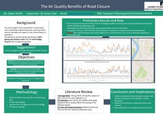
  • 1. The Air Quality Benefits of Road Closure Background The main subject of the dissertation is how events such as flooding, engineering works, sporting events and car free days can impact on the concentration of pollutants. The Research will be looking specifically at 2015 Boxing day Floods in York and the Forth Bridge Closure due to engineering works Objectives Analyse and assess the impact of road closure due to foreseen and unforeseen circumstances has on the concentration of air pollutants Evaluate if road closure can provide a good understanding of the potential air quality benefits of adopting electric vehicles Investigate if disruption can result in changing travel behaviour Methodology • DEFRA AURN Monitoring Sites/ LA Monitoring Sites • UK Met Office/BADC • Statistics from TfS Report on the Forth Bridge • R ‘Openair’ package Literature Review ‘Carmagendden’-Zhang (2013): Air Quality analysis of 36hr closure of a main highway in LA The Olympics- Peel (2010), Zhu (2009): Both paper looked at the air quality effects the hosting of the Olympics games Car Free and Pedestrianisation- Madrid, Bristol and Paris for Car free. Leeds for pedestrian zone Conclusion and Implications • Based on evidence of past disruption events road closure can lead to a 4-5% change in travel behaviour • Potential the pollution is dispersed rather than reduced • Does something more radical need to be done? Preliminary Results and Risks • The Line graphs below show NO2 levels for Fishergate AURN monitoring site (Urban Roadside) and Bootham AURN monitoring site(Background). • Following heavy flooding Fishergate was closed between 26/12/15-07/12/16. • The graphs indicate a 45% reduction of the pollutant compared to the same period the year before. • Caveat: Short period analysis may lead to distortion of normal trends. This is true of pollution episodes or storm aftermath By: Adam Smith Supervisor: Dr James Tate Email: gy11a3s@leeds.ac.uk MSc Transport Planning and the Environment Suggestions? Can you suggest any major disruptions/ road closures across the UK?
  • 2. Control of reflective cracking in asphalt overlays Ahmed M. Abed, MSc Transport Planning and Engineering Institute for Transport Studies. Supervised by Dr. David Rockliff  Background Reflective cracking is considered one of the common defects in asphalt overlays. It can occur as a result of an existing cracking in the underlying layers. Thus, it propagates through a hot mix asphalt (HMA) overlays (Vanelstraete and Francken, 1997). There are several factors which can play an important role in term of producing the reflective cracking. For instance, Traffic loading and environmental conditions such as temperature and moisture content (Baek et al, 2010). It could be argued that each one of these factors has significant impacts on the underlying layers. Consequently, water can find its way to enter between the layers and it will lead to further distress. For example, stripping and a reduction in the bearing capacity of the road surface layer (Pearson, 2012). As a result, structural and functional performance will be affected and it will cause a significant level of deterioration (Bandaru, 2008). Objectives  References - Vanelstraete, A. and Francken, L. 1997. Prevention of reflective cracking in pavements. (RILEM, Report 18). London: E & FN Spon. - Pearson, D. 2012. Deterioration and maintenance of pavements. Institution of Civil Engineers (Great Britain). London: ICE. - Al-Qadi, I., Scarpas, T. and Loizos, A. 2008. Pavement cracking: mechanisms, modeling, detection, testing and case histories. [Online]. Boca Raton: CRC Press. [Accessed 20 February2016]. Available from: http://0- www.crcnetbase.com.wam.leeds.ac.uk/isbn/97802038 82191 - Bandaru, R. 2008. Cost Effective Prevention of Reflective Cracking in Composite pavement. MSc. Thesis. Louisiana State University. [Online]. [Accessed 22 February 2016]. Available from: http://www.ltrc.lsu.edu/ltc_09/pdf/Elseifi,%20Mostafa.p df - Quasco. 2016. Technical Information. [Online]. [Accessed 15 April 2016]. Available from: http://www.rubblization.com/technical- information.html Reflective Cracking Mechanisms Methodology Discussion                                     (Al-Qadi, 2008)  To make a comparison between types of methods which are used to prevent the reflective cracking.  To identify types of reflective cracking and its mechanism, patterns, shapes and crack propagation stages.  To evaluate the performance of control methods such as Geosynthetics, Paving Fabrics, Geogrids, Rubbilization and Asphaltic Surface Treatment (chip seal) in term of long term maintenance by identifying the cost-effective way of each method.  To examine the relationship between asphalt overlays thickness and the reflective cracking. Structural properties of the asphalt overlays Thickness Types Flexible/ Rigid Identifying contributory factors Literatures and research review Control methods Cost-Effective way Performance Practical solutions Causes Traffic loading Environmental conditions Crack opening Shear failure Crack opening Opening Sliding Tearing Causes Traffic loading Environmental conditions Crack opening Shear failure Opening
  • 3. This study will present an optimal design approach for developing a microscopic transportation emissions model (Micro-TEM) by running micro- simulations using a traffic model and integrating the results in an emissions model to an acceptable degree of accuracy (VISSIM and EnViVer). This approach can provide environmental decision makers with practical guidelines for their decisions on environmental transport policies with a specific focus on how to integrate junction design to regulate the local air quality. Since December 1997 each local authority in the UK has been carrying out a review and assessment of air quality in their area. This involves measuring air pollution and trying to predict how it will change in the next few years. The aim of the review is to make sure that the national air quality objectives will be achieved throughout the UK by the relevant deadlines. These objectives have been put in place to protect people's health and the environment. If a local authority finds any places where the objectives are not likely to be achieved, it must declare an Air Quality Management Area there. This area could be just one or two streets, or it could be much bigger. How will this be achieved ?  Primary sources of data – a. Measuring parameters for the existing roundabout (Thornbury Barracks) b. Site data for validation of microsimulation model  Secondary sources of data - a. Classified turn based traffic count from Leeds City Council (LLC) b. Emission details on the roundabout (for last three years) c. Extract results for emissions data from well established transport models What are Air Quality Management Areas? Why are emissions a concern ?  ARCADY to determine Capacity and delays at the existing roundabout.  LINSIG to signalise and record the delays.  Replacing the intersection with all three designs as mentioned above  VISSIM to carry out the micro simulation and derive emissions profile and use EnViVer to analyse spatial distribution and other parameters.  Hypotheses testing contrasting the three junction choices. How will this study benefit ? DATA ANALYSIS 1. The main goal of the study is to improve the local air quality in an urban corridor using a microsimulation modeling technique 2. To propose a reasonable junction design that is in compliance in meeting local air quality objectives under high, medium and low flow levels 1. To monetize the data from emissions model for economic and health impacts 1. Can a microsimulation emissions model show the emissions at a single junction ? What will be its significance w.r.t to the whole network ? 2. Can junction design study with emissions focus, really help the policy makers in taking air quality decisions ? How much can it benefit them ? 3. Can a single junction be monetized for emissions ? Could future junctions be designed with a consideration to emissions too ? Objectives Questions ENVIRONMENTAL ASSESSMENT OF JUNCTION DESIGN BASED ON VARIABLE FLOW CONDITIONS By Ahmer Sadiq (MSc. Transport Planning and Engineering) ¦ Supervisor: Steve Keetley¦ 2nd Reader: Jeremy Shires A junction design analysis for the Thornbury Barracks Roundabout to be carried out based on the indicators obtained from the analysis of emissions data and efficiency variables. ***For analysis, it would require weighing and scoring for each indicator as used above. Key References 1. DEFRA, 2016. Department of Environment, Food and Rural Affairs 2. DMRB, 2016. Volume 11, Section 3. Environmental Assessment Techniques 3. Gokhle, S., 2001. Impact of traffic on vehicular exhaust emissions at traffic junctions 4. Ibrahim, W. and Ramli, N., 2002. A case study of mitigating air pollution emissions at traffic light junctions 5. ELKAFOURY, A., NEGM, A.M., BADY, M.F. and ALY, M.H., VISSIM Based Microscopic Traffic Emission Prediction Model. ***NOTE There are around 470 local authorities in the UK, of which about 200 have declared AQMAs for one or more pollutants. Congestion PM,NOX, SOXFuel Consumption (CO, CO2)Capacity Junction Performance EnvironmentalEfficiency Solution Proposal ANALYSIS OPTIONS What are the flows conditions ? High flows – Peak flows Medium flows – Off Peak flows Low flows – Flows after evening peak DATA REQUIREMENTS
  • 4. Different approaches to car dependence Physical Social Economic •Shrinking HH sizes. •Increasing in labour force participation. •Changing land-use patterns. •Changing commuting patterns •Changing perceptions on travel. •Increasing purchasing power. •… Multiple and complexes reasons. Attitudes towards modes and travel preferences can also be decisive factors to determine transport behaviour and neighbourhood self-selection. •Study the correlation between individual mode choice and the selected land-use variables and personal attributes. •Make a global regression model between mode choice and the selected land-use variables and personal attributes for the respondents of the survey. •Determine the degree of correlation between the variables selected and mode choice using geographically weighted regression. Objectives There is a strong relationship between the built environment and travel behaviour. Therefore policies to tackle car dependence should focus on changing transport behaviour by land use policies and transport provisions that make car travel less necessary or less attractive. . . . . . . . . . Commuting to the University of Leeds; a geographic analysis of car dependence. •Congestion and its environmental and economic consequences. •Pollution (Noise, NOx, Ozone...) •The decline of public transport •Health effects caused by the reduction in active mobility (obesity) and road safety itself. •Commercial viability of town centres. •Frustrated mobility. •Decrease in urban quality. The excessive use of private cars is the source of most urban transport problems. The effects of road transport emissions are not only local: Other 74% Road transport 20% Other transport 6% Transport 26% Global CO2 Emissions And despite the commitments on reducing GH gasses emissions, they keep increasing for the transport sector. Other studies determined that personal characteristics and socioeconomic factors have the wider influence in travel behaviour. Attributes like level of income, car-ownership or household structure are usually considered decisive in this approach. Research question Mode share among commuters to the University of Leeds is influenced by geography. Specifically I hypothesise that mode choice is correlated with density, land-use mix, accessibility and design of the trip origins. Methodology and data Built environment variables The LSOAs of the UoL catchment area will be classified by density (residents and jobs), land-use mix, accessibility to key services and pedestrian and cycling facilities using ArcGIS. Density: Census data and workplace population data. Land-use mix: An entropy measure will be created using Arc GIS. Data from OS Mastermap “sites” layer: FunctionThemeValue containing areas for education, medical care, bus station, railway station and industrial. Accessibility: DfT Journey time statistics Travel time to nearest town centre by PT/Walk. Pedestrian and cycling facilities: Length of pathways per hectare and length of cycle lanes per hectare. Data from OS Mastermap and Leeds Data Mill. The built environment variables most widely accepted to have a strong correlation with travel behaviour are: accessibility, mixed-use, density and design. Main references CERVERO, R. & KOCKELMAN, K. 1997. Travel demand and the 3Ds: Density, diversity, and design. Transportation Research Part D: Transport and Environment, 2, 199-219. CHAPMAN, L. 2007. Transport and climate change: a review. Journal of Transport Geography, 15, 354-367. CRANE, R. 2000. The influence of urban form on travel: an interpretive review. Journal of Planning Literature, 15, 3-23. EWING, R. & CERVERO, R. 2010. Travel and the Built Environment: A Meta-Analysis. Journal of the American Planning Association, 76, 265-294. HOYLE, B. S., KNOWLES, R., INSTITUTE OF BRITISH, G. & ROYAL GEOGRAPHICAL SOCIETY . TRANSPORT GEOGRAPHY RESEARCH, G. 1998. Modern transport geography, Chichester, Wiley. HUNECKE, M., HAUSTEIN, S., GRISCHKAT, S. & BÖHLER, S. 2007. Psychological, sociodemographic, and infrastructural factors as determinants of ecological impact caused by mobility behavior1. Journal of Environmental Psychology, 27, 277-292. LUCAS, K., BLUMENBERG, E. & WEINBERGER, R. 2011. Auto motives: understanding car use behaviours, Bingley, Emerald. SANTOS, G., BEHRENDT, H. & TEYTELBOYM, A. 2010. Part II: Policy instruments for sustainable road transport. Research in Transportation Economics, 28, 46-91. STEAD, D. 2001. Relationships between land use, socioeconomic factors, and travel patterns in Britain. Environment and Planning B: Planning and Design, 28, 499-528. Context and background It is essential to understand the relationship between these variables and travel behaviour in order to design policies and land-use strategies that help to deliver more sustainable cities. Step 1: Add the land-use attributes of the area where the respondents live to the survey dataset and perform a logistic regression model between mode choice (PT-car binary dependant variable) and the built environment variables and job position as independent variables. Data from the university travel survey: Postcode, job position and main mode (car/PT). Built environment variables data. The logit regression will be carried out using R. Step 2: Map the regression residuals and check for spatial patterns. ArcGIS and R will be used for this step. Step 3: Make a Geographically Weighted Regression model, map the results and interpret the data. The regression will be made using R, Gwmodel package or similar.
  • 5. EVALUATING THE USE OF MOBILE PHONE DATA IN MOBILITY MODELLING USING A SIMULATED NETWORK Author: Alex Patrick (MSc Transport Planning) Supervisor: Charisma Choudhury 2. Background :  Each time a mobile phone is used, the network provider can determine its rough location by recording which cell tower received the original signal. It is then possible to plot a travel diary for individual by plotting their phone signal. Restrictions of Mobile Phone Data:  Temporal Resolution: A phone only transmits a signal intermittently, and so there is nothing to suggest that a phone user took a direct path between two signal locations. A long enough delay between consecutive signals from a user could lead to entire trips missing from the data.  Spatial Resolution: i.e. the imprecision in the recorded location. Per Fig 1, even in a busy area cell towers can be sparse. The cell tower that receives a signal may not even be the nearest. It is necessary, then, before hoping to draw reliable conclusions from mobile phone-based mobility data, to examine the extent to which these influences reduce its quality and accuracy. 1. Research Objectives:  Determine the extent to which mobility data derived from mobile phone usage records describes real-life travel patterns.  Investigate the sensitivity of mobility data quality to differences in the spatial and temporal resolution of the mobile phone data from which it is derived. Fig 1: Cell Tower Locations around The University of Leeds. Source: openstreetmap.org and OfCom 3. Method :  The Fundamental Problem justifying this project is the lack of a ground truth we can use to validate phone data. It is necessary, then, to use simulation to engineer a situation where we have both.  The Ground Truth would ideally be produced by using a set of real travel diaries to accurately inform trip generation and distribution in the simulation. Failing this, however, it will be necessary to create a simulation from scratch, though perhaps some less complete data would still be useful for informing this process. Previous similar work has been done in MATSim, while UrbanSim would also be a good choice due to its detailed simulation of agents’ short-term choices regarding activity generation and location, as well as mode choice.  Phone data for comparison will be generated synthetically based on the output of the simulation, and according to the restrictions of real phone data, by recording a set of discrete points detailing the nearest cell for each agent identity at random times.  Simulating Temporal Resolution: β is an estimate of the average number of signals transmitted per agent per day. Using β, for each agent there is a binomial probability each minute that a data point will be created. - Estimating β: It will be necessary to experiment with a variety of values for β according to whether a signal can only be call, or whether the term includes use of mobile data or even involuntary connections.  Simulating Spatial Resolution: It will be necessary to define cells on the simulated network in order to gather the required data. - Cell tower locations are available from OfCom. This may provide insight into the size of cells on a general network, or could be used to accurately define cells on the real-life network used for the simulation.  Sensitivity Analysis will consist of trying a number of levels for the two resolutions, primarily by altering β and cell size, with the goal of testing how different resolutions influence the results. Unfortunately, rarely is a set of data gathered from mobile phone signals accompanied by a known ground truth to compare it to. In order to make a good assessment of its quality, we must create our own... 4. Results & Beyond:  The simplest measure of data quality is the difference in total metres travelled recorded in the two datasets ie. how much travel is missed when using phone data. It will also be necessary to explore other measures.  Investigating different types and sizes of networks e.g. towns, city centres, highways as well as perhaps considering how resolutions might be different in the future would provide an interesting extension to this work and determine whether phone data is more applicable in certain situations than others.
  • 6. AN ASSESSMENT OF VARIOUS APPROACHES TO ROAD MAINTENANCE FINANCING IN DEVELOPING SUB-SAHARA AFRICAN COUNTRIES- A CASE STUDY OF SIERRA LEONE Alie M. Forna-MSC Transport Planning and Engineering | Tony Plumbe (Supervisor) | Jeffery Turner (2nd Reader) Background  Massive funding gap to meet transport infrastructure maintenance needs in developing sub-Saharan African countries  A need to understand why and how this problem can be minimised.  Any savings made on required maintenance, leads to increase in vehicle operating costs over the road life and rehabilitation or reconstruction cost can be around 20 times more than maintenance cost.  Minimize this funding gap and potentially reduce whole life cost of road network in developing Sub-Sahara Africa Research Questions  How effective are current approaches to road maintenance financing in developing countries in meeting maintenance needs  What alternatives could be adopted to gain improvements? Objectives  Identify possible options to maintenance funding based on international experiences  Assess performance of the more common methods of road maintenance financing in Developing African Countries in meeting the maintenance needs, using Sierra Leone as the primary case study  Highlight the merits of various approaches and make recommendations for approaches to be adopted based on perceived acceptability and sustainability Current Situation of Case Study Area Methodology Road Maintenance Finance Options Scope Expected Outcomes Focus on current levels of Road User Charges in Sierra Leone and other developing countries and financing alternatives over the last 30 years. At least one of these countries should not have a road fund approach and draw comparisons to at least one developed country. Questionnaire survey will focus on transport professionals experience and perception in Sierra Leone.  Effectiveness of current road maintenance financing approaches  Potential options to road maintenance financing  Perceived acceptability of potential options among transport professionals in Sierra Leone  Improvement recommendations for current approaches or alternatives in Sierra Leone  Identify Road Financing Options (Literature Review/Systematic review)  Assess Current Approach in developing countries in fulfilling maintenance needs(By data Analysis of primary and secondary data/Questionnaire Survey)  Feasibility of Alternatives(Data Analysis of Secondary data and Questionnaire Survey)  Compare & Contrast current and identified approaches  Conclusions Major Road Network in Sierra Leone Potential Cost savings of timely maintenance Intervention for road pavement ??? Required Funding: $3.1Billion Available Funding(Road Fund): $16.2Million Funding Gap: $3.1Billion
  • 7. EX-POST ANALYSIS OF WIDER ECONOMIC IMPACTS OF LIGHT RAIL SCHEMES Institute for Transport Studies Researcher: Alvaro Guzman de Damas MSc (Eng) Transport Planning and Engineering Faculty of Environment Supervisor: Daniel Johnson Second reader: Judith Wang 1. BACKGROUND Local governments have a great interest in the potential of new public transport schemes however they are reluctant because of the investment needed. There are two aims of transport spending. First, to reduce transport cost to business and commuters and second, to stimulate the national and local economies. Two key policy aims: - To respond to growing demand to prevent congestion. Therefore, investment will be allocated where the economy and demand is growing. (Eddington Review) - To stimulate local economies. By connecting people, firms and places more closely create “agglomeration economies”, which increase productivity. Consequences of Light rail schemes on local economic growth. - Public sector infrastructure investment provides capital stock that is complimentary to private sector and to human capital. - To provide a network that connects different places. The investment reduces transport costs between places. Still more empirical work remains to be done on understanding the impact of light rail on local economic growth to help decision makers.(What Works Centre for Local Economic Growth,2015) 2. MAIN OBJETIVE AND SCOPE OF THE RESEARCH To determine if there has been discernible wider economic impacts of light rail schemes by using ex-post analysis with a number of case studies across England . The dissertation will focus on employment effects and changes in mode share for commuters - Are wider economic benefits missed in cost-benefit analysis? The results will inform the debate on the impact of public transport investment on the wider economy and help to understand if whether people move from car or are attracted from other public transport following that such investment. 3. METHODOLOGY How to isolate the effects of the policy from other influences that may be at the same time operating? Difference-in-Difference: Use of adequate control variables in macro levels factors and a before-and-after comparison of treated group, with an untreated comparison group. Control areas: represent what ha occurred in the light rail corridors if LR schemes had no been built. It should be as comparable as possible with the LR corridors, but should not have had any LR investment. - Areas should have similar range of distances to the LR. - DID relies on the strong identifying assumption that the average outcomes for the treated and control groups would have followed paths over time in the absence of the treatment. In order to estimate the impact of the light rail it will be use: Measures of accessibility with employment and commuting modes. 4. DATA COLLECTION - From Census data. ONS (NESS). - Dft - data.gov.uk - Transport for Greater Manchester… 5. REFERENCES BANISTER, D. & BERECHMAN, J. 2000. Transport investment and economic development, London, UCL Press BERTRAND, D.M., DUFLOR, E. & MULLAINATHAN, S. 2004. How much should we trust difference-in-differences estimates? Quarterly Journal of Economics 119, 249-275. DfT (2014b) TAG Unit A2.1 Wider Impacts, Department of Transport. FITZROY, S.; WEISBROD, G.; STEIN, N. (2014), TPICS, TIGER and US Experience: A Focus on Case-Based Ex Post Economic Impact Assessment. Discussion Paper No 2014-11, International Transport Forum at the OECD, Paris. GIBBONS S. 2015 Planes, Trains and Automobiles: The Economic Impact of Transport Infrastructure. SERC and London School of Economics. GRAHAM, D. J.; BRAGE-ARDAO, R.; C. MELO, P. (2014), Causal influence for ex post evaluation of transport interventions. Discussion Paper No 2014-13. International Transport Forum at the OECD, Paris. JOHNSON. D, MACKIE. P, 2014. Task 3 Report: Econometric Analysis. Buses and the Economy II. Institute of Transport Studies, University of Leeds. Marco Ercolani, University of Birmingham. SHIN S. LEE, MARTYN L. SENIOR. 2013. Do light rail services discourage car ownership and use? Evidence from Census data for four English cities. Journal of Transport Geography. VICKERMAN, R. 2007. Recent evolution of research into the wider economic benefits of transport infrastructure investments. Discussion paper No.2007-9. Centre for European, Regional and Transport Economics, University of Kent. What Works Centre for Local Economic Growth. 2015, Evidence Review 7. Transport.
  • 8. KEY DRIVER OF CITIZEN SATISFACTION IN TRANSPORT AND HIGHWAY SERVICES Author: Supervisor: Co-Supervisor:Argasadha Retapradana Phillip Wheat Alex Stead ts15ar@leeds.ac.uk Public Satisfaction Survey 12 Region, 100 Local Authorities in England and Scotland 100 6050 55 low average high was done annually to provide information about citizen satisfaction to Local authorities Based on the result of the survey, public satisfaction on transport and highway service is relatively low. Local Authorities are facing a challenge to improve their service with less budget. There is a need to understand how this public satisfaction survey result help local authorities to improve their service. Aim: Help Local Authorities to understand key driver of citizen satisfaction in transport and highways services using NHT survey result Objectives: 1.Identify the influence of transport and highway services on citizen satisfaction 2. Analyse the effectiveness of local authority’s services in increasing citizen satisfaction METHODOLOGY Key Driver Analysis: Understanding key service which drives customer’s satisfaction Multiple regression is the common method to quantify the influence of service attributes on customer’s satisfaction Y = b + b X + b X + b X + … + b X0 1 1 2 2 3 3 n n 1. Perform regression analysis to explain overall citizen satisfaction using result of satisfaction question to general services (Key Benchmark index) to get key drivers 2. Analyse what affect citizen satisfaction of these key driver using level of satisfaction on specific services (benchmark index and physical attributes of services) 3. Perform descriptive analysis to assess local authority performance based on the result of key drivers analysis NHT SurveyResultcanbeobtainedfrom: http://nhtsurvey.econtrack.com DATA COLLECTION AIM AND OBJECTIVES BACKGROUND 2015 SCOOP OF STUDY Citizen satisfaction level is categorised in six themes consist of twenty six key benchmark indicators, and breaked down to over one hundred benchmark indicators Key Benchmark Index Key Benchmark Index Key Benchmark Index BI and Service Attribute BI and Service AttributeBI and Service Attribute BI and Service Attribute STAGE 1 Public Transport Walking/Cycling Tackling Congestion Road Safety Highways Maintenance STAGE 2 BI and Service Attribute Accessibility
  • 9. “What are the fuel consumption and emission penalties of traffic congestion?” Student: Ariadni Michou, Msc Transport Planning and the Environment Supervisor: Dr. James Tate INTRODUCTION: SCOPE: METHODOLOGY: Source: (neighbourhood.statistics.gov.uk/) Actual speed comparing to free flow speed >85% 85%-70% 70%-55% 55%-40% 40%-25% <25% LOS A B C D E F Analysis of tracking data 1 HZ from Headingley in Leeds Instantaneous Emission Model: PHEM Identifying the type of congestion through the Level Of Services Method. Analysis of congestion impacts to the environment Nowadays air pollution from vehicles is a major issue of cities. Traffic congestion influences the air quality of urban areas. The impacts of air pollution to human’s health are negative and the analysis of key pollutants concentrations is imperative. How traffic congestion and fuel consumption are linked ? How we can quantify the impact of congestion to environment? There are key questions from those trying to understand this relation The scope of this research is the explanation of the linkage of fuel consumption with traffic congestion, driver’s behavior and vehicle’s movements. These factors affect the pollutants concentrations and the impacts to environment are more understandable. PHEM : PHEM is a comprehensive power-instantaneous emission model that is able to simulate fuel consumption and tail-pipe emissions of the whole vehicle fleet REFERENCES Tate J., Wakefield Modelling of Action Plan Measures - Vehicle Emission Modelling, Version 1.2, University of Leeds, 2015 TRANSPORT RESEARCH BOARD , Highway capacity annual, 2000 http://neighbourhood.statistics.gov.uk/ Headingley, is an often congested area in Leeds. The findings about the drive behavior and vehicle’s movements present the situation in traffic conditions. The link of the data analysis is located in an urban area. The examination of urban Levels of Services follows the next figure. Speed(km/h) Traffic flow ( vehicles/h)
  • 10. Armando Orta Madero - MA Transport Economics | Supervisor: Prof. Simon Shepherd | Co-Supervisor: Dr Chandra Balijepalli 1 Motivation OPENING SKIES BETWEEN MEXICO AND THE UNITED STATES: AIR PASSENGER COMPETITION IN A SYSTEM DYNAMICS CONTEXT Institute for Transport Studies FACULTY OF ENVIRONMENT § The air passenger traffic between Mexico and the United States has grown approximately 40%, between 2005 and 2015. (SCT, 2015). § Current bilateral agreement allows for each country to assign two airlines for each route, with some exceptions (three airlines). § Some routes have reached airline capacity, limiting competition. § In 2015, a new agreement was negotiated to eliminate any restrictions for market entry. 3 Methodology: System Dynamics 2 Research questions 4 Empirical evidence 5 References Lyneis, J.M. 2000. System dynamics for market forecasting and structural analysis. System Dynamics Review. 16(1), pp.3-25. Morecroft, J. No date. System Dynamics, RBV and Behavioural Theories of Firm Performance: Lessons from People Express. Ros, AJ. 2011. The Determinants of Pricing in the Mexican Domestic Airline Sector: The Impact of Competition and Airport Congestion. Review of Industrial Organization. 38(1), pp. 43-60. Schipper,Y., Rietveld, P., Nijkamp, P. 2002. EuropeanAirline Reform: An Empirical WelfareAnalysis. Journal of Transport Economics and Policy. 36(2), pp. 189-209. Secretaría de Comunicaciones y Transportes. 2015. Aviación Mexicana en cifras 1993-2015. [Online]. [Accessed 15 April 2016]. Available from: http://www.sct.gob.mx/transporte-y-medicina-preventiva/aeronautica- civil/estadisticas/aviacion-mexicana-en-cifras-89-15-only-in-spanish/ Silva, H.E., Verhoef, E.T. and van den Berg, V.A.C. 2014. Airline route structure competition and network policy. Transportation Research, Part B. 67, pp.320-343. Sterman JD. 2006. Learning from Evidence in a Complex World. American Journal of Public Health. 96(3):505-14. Suryani, E., Chou, S.-Y. and Chen, C.-H. 2010. Air passenger demand forecasting and passenger terminal capacity expansion: A system dynamics framework. Expert Systems WithApplications. 37(3), pp.2324-2339. U.S. Department of Transportation. 2015. Bureau of Transportation Statistics. [Online]. [Accessed 15April 2016]. Available from: http://www.transtats.bts.gov/Fields.asp?Table_ID=260&SYS_Table_Name=T_T100I_MARKET_ALL_CARRIER&User _Table_Name=T- 100%20International%20Market%20%20(All%20Carriers)&Year_Info=1&First_Year=1990&Last_Year=2015&Rate_In fo=0&Frequency=Monthly&Data_Frequency=Annual,Quarterly,Monthly § SD models account for feedback between variables across time and delays in responses to implemented policies. (Sterman,2006) § They may provide more reliable forecasts for the short and medium-term trends. § SD models are a useful tool for understanding industry and firm behaviour. (Lyneis, 2000) Airline capacity limitreached (US) 65% of the top 20 routes are either saturated or semi-saturated 72% of overall traffic between Mexico and the United States was carried by US companies in 2015 Will the new air transport agreement create more competition in high demand markets? Will there be a sustained effect on fares if there are new airlines operating in a route? What is the role of runway capacity and airline business cycles on market contestability? Ho-Yeol Ryu. 2005.Flughafen[Airport], subjectto copyright. 5,826,500 6,874,000 11,998,000 18,116,000 2005 2015 MX Companies US Companies Airline capacity limitreached (MX) Airline capacity available (MX) Airline capacity available(US) Figure 2. Top 20 routes by airline capacity limit and traffic (2015) Source:Own work with information from SCT(2015,p.45) Source:Own work with information from USDoT(2015) Data from January to October. Size indicates traffic volume,color differentiates route. Via thewenetwork.org, subject to copyright. Via Crupo Aeroportuario de la Ciudadde México(GACM) Figure 1. Air passenger traffic growth between Mexico and the US Why System Dynamics (SD)? Literature review and data analysis 3.1 Methodology Development of mental model / Causal Loop Diagram Functional form assignment for variable interaction, using evidence from literature Model simulation Evaluation and interpretation of results Figure 3.Example of a Causal Loop Diagram for a competing airline Source:Based on Morecroft,no date,p. 5 and Suryani etal.,2010,p.2327. 4.1 Europe: Schipper, et al. (2002) 4.2 Mexico: Ros (2011) 𝑝" # = 𝑑𝑐" # 𝑑𝑞" − 𝑞" # 𝑑𝑝# 𝑑𝑞# (1 + 𝛿) 𝛿 = 𝑝.# − 𝑑𝑐" .# 𝑑𝑞" .# 𝑑𝑞.# 𝑑𝑝# > 0 𝛿 = 0 Regulated market scenario (collusive behaviour) Liberalised market scenario (non-cooperative behaviour) § Analised the welfare effects of the liberalisation of intra- European routes. § Using econometric analysis, authors concluded that fully liberalised routes had fares 34% lower than the non-liberalised counterparts. Figure 4. Profit maximising price equation for airline i on route r § There has been a decrease of 25% on air fares for routes where incumbent airlines compete with low-cost carriers. § Due to capacity constraints of Mexico City airport, airlines are able to charge approximately 70% higher fares than in a competitive situation, on selected routes. Model: C:UsersaortamDocumentsVensim PracticalsPresentationPosterDiagram.mdl View: View 1 Plane purchases Planes Passenger capacity Passenger miles Load factor Growth target Company's growth vision Company growth rate + + + + + Service capacity Service quality Service reputation Airline passenger demand Marketing spending Relative fare Rival's fare Airline fare Rival's cost + - + + - + + + - + Airport runway congestion Runway utilisation Runway capacity GDP growth rate PopulationPrice elasticity - - + + + + + + - + + - - + - -
  • 11. CURRENT WORK • Small 5 link Network: • Link Travel time: BPR function: 𝑐 𝑎 𝑣 𝑎, β 𝑎 = 𝑐0 𝑎 1 + 0.15 ∗ (𝑣 𝑎/(β 𝑎 + 𝑦𝑎 ) ^4) Where, 𝑦𝑎, increase in capacity • Ranking based on overall welfare for increased capacity in each scenario DETERMINING COMBINATION OF CRITICAL LINKS IN A NETWORK TO INCREASE THE OVERALL WELFARE USING AN OPTIMIZATION SOLVER Presented by: Binshid Chalil Mohamed - MSc. Transport Planning and Engineering , Supervisor: Dr. Chandra Balijepalli OBJECTIVES • Identify a combination of links, whose capacity increase can ascertain improvements in overall welfare of the network users. • Test the scenario on a real world network to illustrate improvements in the network due to capacity enhancement of critical links. METHODOLOGY • The problem is a Bi-Level Programming Problem including the maximization of objective function (ѡ) and minimization of User Equilibrium (UE) constraints. max ѡ = 𝑎𝜖𝐴[ 1 2 𝑡0 𝑎 − 𝑡1 𝑎 𝑣0 𝑎 + 𝑣1 𝑎 ] - 𝑎𝜖𝐴 ia 𝛽a Subject to, 𝐜(𝐯∗ , 𝛽) 𝑇 . 𝐮 𝑒 − 𝐯∗ − 𝐃−𝟏 𝐝∗ , 𝛽 𝑇 . 𝐪 𝑒 − 𝐝∗ ≥ 0, e ϵ E 𝑟𝜖𝑅 f 𝑟𝑘 = d 𝑘 𝑣 𝑎 = 𝑘𝜖𝐾 𝑟𝜖𝑅 𝑘 𝑓𝑟𝑘 𝛿 𝑎𝑟 𝑓𝑟𝑘 ≥ 0 𝑎𝜖𝐴 , 𝑘𝜖𝐾, 𝑟𝜖𝑅 𝑘 • Where, Ѡ, Objective function K, Set of Origin-Destination pairs d, demand function A, Set of links in the network 𝑐 𝑎 𝑣 𝑎, β 𝑎 , Cost of travelling on link a, aϵA Rk, Set of all paths connecting O-D pair k, kϵK 𝑡0 𝑎 , Travel time on link a before capacity enhancement, aϵA 𝑡1 𝑎 , Travel time on link a after capacity enhancement, aϵA 𝑣0 𝑎 , Link flow on link a before capacity enhancement, aϵA 𝑣1 𝑎 , Link flow on link a after capacity enhancement, aϵA 𝑓𝑟𝑘, flow on path r, rϵ Rk, kϵK 𝛿 𝑎𝑟, binary value function, where value equals 1, if route r uses link a 𝑖 𝑎, Unit capacity investment cost for link a, aϵA 𝛽 𝑎, Capacity on link a, aϵA • Since it is a Bi-Level Problem, the Lower Level Problem was re-written as a Variational Inequality, to reduce it to a single maximization problem, called MPEC (Mathematical Programming with Equilibrium Constraints), which can be solved with algorithm like CCA (Constraint Cutting Algorithm). • The CCA sets up the optimization problem with the variational inequality conditions of the traffic equilibrium as a constraint. FUTURE WORK AND EXPECTED FINDINGS • Considering elastic demand, find out possible link combinations for a real world network using a suitable programming language. • Setup the following scenarios and test the objective function: - One link - Two link - All links REFERENCES • Koh, A., Shepherd, S. & Sumalee, A., 2009. Second best toll and capacity optimisation in networks: solution algorithm and policy implications. Transportation, 36(2), pp. 147-165 • Wang, D. Z., Liu, H., Szeto, W. & Chow, A. H., 2015. Identification of critical combination of vulnerable links in transportation networks-a global optimization approach. Transportmetrica A: Transport Science, pp. 1-20. MOTIVATION? • Where should transport policy makers invest the money for development (Reduction in Travel Time, Overall Benefit)? • Is capacity increment of all links required to draw efficiency to a network? Or are certain links capable of doing so? Critical links Overall Welfare 1 57.36 2 43.015 5 39.34 4 26.29 3 -43.198 Ranking Link No Free flow (c⁰) Capacity β ROH Cost Overall Welfare Capacity Inc (ya) Inc cap link 1 1 4 40 86.16 -28.8 57.36 40 Inc cap link 2 2 6 40 71.815 -28.8 43.015 40 Inc cap link 3 3 2 60 0.0014 -43.2 -43.1986 60 Inc cap link 4 4 5 40 55.09 -28.8 26.29 40 Inc cap link 5 5 3 40 68.14 -28.8 39.34 40 Link Specifications Results Scenario
  • 12. Is the cycle time at pedestrian crossings long enough to enable elderly people to cross? Charles Dunkley: Transport Engineering and Planning MSc Supervisor: Dr Frank Lai Background The elderly population in the UK is growing and so there are now more people over the age of 65 than ever before. It has been identified that there needs to be more investigation into how long different groups of elderly people take to cross the road. From UCL research it has been shown that those with slower crossing times are from more deprived areas, which will also be investigated. The report also said that the crossing time allowed was not enough for most elderly people and that it should be increased. Thus there will be different locations picked based on where there will be a lot of elderly people to look further into this. Research questions 1. To determine the crossing speed for different groups of elderly people. The different groups would include, people who walk with a mobility aid such as a walking stick, people who have no mobility aid and people carrying bags. 2. To determine the optimum cycle time of lights to accommodate the slowest elderly group. 3. To determine whether coming from a more affluent area has an effect on crossing time. Method Identify three traffic light controlled pedestrian crossings, two of which are used heavily by elderly people and one as a control that is used by younger people. One of the two elderly people crossings will be in Harrogate by the bus station. This is because Harrogate is a fairly affluent area and from prior knowledge there are lots of elderly people who use the crossing. The other crossing will be in Crossgates on Austhorpe Road which isn’t as affluent as Harrogate but has a lot of elderly people. So from this it should be able to show whether being from a less affluent area is a factor. The control crossing will be in Crossgates on Station Road by the train station which is a busy crossing used by a wide range of people. Time how long it takes for the elderly person to cross the road and note down any characteristics of the person, eg carrying shopping or using mobility aids (non-mechanical). Analysis Group different characteristics that have been identified from the data collected and produce times for the different groups of elderly people. Compare the times from each identified group to the time that was allowed at that crossing by the local authority and to what is laid down in the relevant British Standard. Expected contribution This could be used by highway authorities to decide on the length of time to allow at a crossing where there is likely to be lots of elderly people. New knowledge that would be generated would show how long different groups of elderly people take to cross the road compared to the time allowed. Also if coming from a more affluent area affects the crossing time of elderly people. References Aresu, M., Asher, L., Falaschetti, E. and Mindell, J. 2012. Most older pedestrians are unable to cross the road in time: a cross-sectional study. Age and Aging. [Online]. 41, pp. 690-694. [Accessed 23rd April 2016]. Available from: http://ageing.oxfordjournals.org/content/41/5/690.full.pdf+html Bill, A., Gates, T., Noyce, D. and Van Ee, N. 2006. Recommended Walking Speeds for Pedestrian Clearance Timing Based on Pedestrian Characteristics. [Online]. [Accessed 23rd April 2016]. Available from: https://www.researchgate.net/profile/Andrea_Bill/publication/228368729_Recommende d_walking_speeds_for_pedestrian_clearance_timing_based_on_pedestrian_characteristi cs/links/02e7e52867c5dd33aa000000.pdf Office for National Statistics. 2012. Population Ageing in the United Kingdom, its Constituent Countries and the European Union. [Online]. London: Office for National Statistics. [Accessed 23rd April 2016]. Available from: http://webarchive.nationalarchives.gov.uk/20160105160709/http://www.ons.gov.uk/ons /dcp171776_258607.pdf
  • 13. Methodology: I will review the existing literature and guidance to establish the current practice for the Strategic Road Network and Local Authority roads. I will contact the National Federation of Housebuilders, individual housebuilders and key sub-contractors involved in the construction of Local Authority roads to establish where innovation has been incorporated and where it has not to identify any blockers. I will then try to propose an alternative foundation design and review this using analytical design methods to check whether it would be suitable for the relevant loading conditions. Objective: The objective of this work is to establish how much of IAN73/06 has been and can be transferred to the design and construction of lightly trafficked roads. Pavements: Is there scope for innovation in lightly trafficked roads? Introduction: The aim of my research is to investigate whether Local Authorities can revise their pavement construction specification, specifically with regards to the foundation, of lightly trafficked roads to allow for innovation and efficiencies across the industry. University of Leeds, Institute for Transport Studies MSc (Eng) Transport Planning and Engineering Student: Charlotte Wright (ts14caw@leeds.ac.uk) 29th April 2016 Supervisor: David Rockliff Second Reader: Jeremy Shires Background: In February 2006, Highways England (formerly the Highways Agency) published IAN73/06 to replace HD25/95. IAN73/06 introduced four ‘restricted’ design classes and the use of ‘performance’ design to increase the strength of the foundation which allowed the required thickness for the bound layers (surface, binder and base courses) to be reduced and as the bound layers are typically more expensive this can result in significant savings across larger schemes. 1979 •West Yorkshire Highway Design Guide 2009 •Leeds City Council Street Design Guide 2012 •Wakefield Council Street Design Guide 1960 •Road Note 29 1984 •TRRL 1132 1994 •HD25/94 2004 •TRL Report 615 2006 •HD26/06 2006 •IAN 73/06 Surface Course Surfacing Binder Course Upper Base Base Lower Base Subbase Capping Foundation Subgrade (existing ground) 1992 •Design Bulletin 32 1998 •Places, Streets and Movement. 2007 •Manual for Streets 2010 •Manual for Streets 2 Indicative Findings: The foundation design may be constrained by the loading of a single vehicle, such as the bin lorry, rather than the level of traffic over its expected life. Scope: I will focus on lightly trafficked, Local Authority roads that are not used as a bus route and do not have a distributor function. Sources of Information: • Pavement design guidance • Street design guidance • Local authority design guidance • National Housebuilders Federation members • Consultants involved in pavement design • Housebuilding contractors and subcontractors • Research papers Pavement Design Guidance Street Design Guidance Local Design Guidance
  • 14. My beautiful busses: the role of art in public transport.
  • 15. ? LITERATURE REVIEW Integrating weather conditions into railway infrastructure cost functions Davide Bruscoli, MA Transport Economics candidate Supervisor: Dr Andrew Smith, Institute for Transport Studies Co-supervisor: Dr David Dawson, School of Civil Engineering OVERVIEWCOSTFUNCTIONCLIMATECHANGE  Weather conditions, either normal or exceptional, have an impact on the cost of railway infrastructure maintenance TRACK BUCKLING: A deformation of the rail due to high temperature SNOW REMOVAL: To allow regular circulation of trains BRIDGES: Heavy rains can accelerate scour and compromise structural integrity. Bridges also suffer from temperature deformation TRACKBED: Heavy rains and flash floods can accelerate erosion SIGNALLING AND OVERHEAD LINES: Can be damaged by low temperatures and storms We want to use Econometrics to investigate the problem  There is currently little empirical evidence on the impact of weather on railway maintenance costs  There is data on the French railway network we can use ! WHY? WHAT? We build a COST FUNCTION of the French railway network, where we seek to incorporate climate-related variables  How do we define sensible climate variables that can capture the impact of weather on costs?  How much of the variation in costs is explained by different climatic conditions? We explore the possibility of estimating the potential impact of CLIMATE CHANGE on railway maintenance costs by using the cost function we have estimated CORE COMPONENT OF THE DISSERTATION THIS COMPONENT IS MORE SPECULATIVE / PREPARATORY FOR FUTURE RESEARCH References: Gaudry, M., Quinet, E. (2009) Deliverable 8 – Rail Cost Allocation for Europe – Annex 1Di – Track Maintenance Costs in France. CATRIN (Cost Allocation of TRansport INfrastructure cost). Version 2.1, 25 February. Odolinski, K. and Smith, A.S.J. (forthcoming), Assessing the cost impact of competitive tendering in rail infrastructure maintenance services: evidence from the Swedish Reforms (1999 to 2011), Journal of Transport Economics and Policy (accepted June 2015). Nemry, F., Demirel, H. (2012) Impact of Climate Change on Transport: A focus on road and rail infrastructure, JRC Scientific and Policy Reports, European Commission. Acknowledgments: We thank the Société nationale des chemins de fer français (SNCF) for the provision of cost and weather data on the French railway network. METHODOLOGY DATA COLLECTION AND PREPARATION VARIABLES SELECTION AND DEFINITION FUNCTIONAL FORM MODEL ESTIMATION HYPOTHESIS TESTING INTERPRETATION AND INDICATIONS FOR FURTHER RESEARCH GENERAL REFERENCES:  Odolinski and Smith (forthcoming) is the only known railway cost function study (Swedish rail network) where a climate variable (yearly precipitations of snow) is incorporated and found to be significant.  Among the studies on France, our main reference is Gaudry and Quinet (2009). This study is part of the Cost Allocation of Transport INfrastructure Cost (CATRIN) project. SNCF will provide data on:  Railway infrastructure characteristics;  Volumes of traffic sustained;  Maintenance cost incurred;  Weather conditions. The data will cover more than 1000 sections of the French network for three years of operations. Research on infrastructure marginal cost suggests that a Box-Cox model can explain the data better than an equivalent double-log model. In a BOX-COX model variables are transformed by: 𝑥 𝜆 = 𝑥 𝜆 − 1 𝜆 where 𝑥 𝜆 is a variable and 𝜆 a parameter to estimate. DEFINING WEATHER VARIABLES: Crucial to effectively capture the impact on costs  At a simplest level, the effect of weather can be captured by including geographical dummy variables based on the main climatic zones of France – but this would not exploit the rich dataset we have !  Alternatively, we can define weather variables based on sensibly-defined “trigger points” (e.g. number of days in a year with average daily temperature above 30 °C);  A problem with this latter approach would be the inability of explaining surges in costs caused by extreme weather events that would not be captured by a generic weather variable. In this case it may be necessary to control for the occurrence of extreme events. Can this improve understanding cost data variations? Can this be used to estimate the impact of climate change on maintenance costs? PARIS COMBINED AND LAGGED EFFECTS  Studies on roads suggest that weather conditions and heavy traffic may combine to accelerate asphalt deterioration. Do combined effects exist in rail as well?  If so, introducing interactions (e.g. between a temperature variable and traffic by heavy freight trains) may be considered.  One more modelling challenge: the cost of repairing weather-induced deterioration may be incurred after a lag (lagged effect). Can we use our ‘climate-enhanced’ cost function to estimate the impact of climate change on the cost of maintaining the French railway network? TAKE THE ESTIMATED PARAMETERS OF CLIMATE VARIABLES… …MULTIPLY THEM BY MANIPULATED CLIMATIC VARIABLES REFLECTING POSSIBLE FUTURE CLIMATE CONDITIONS… …TO GET BASELINE ESTIMATES OF CLIMATE CHANGE IMPACT ON MAINTENANCE COSTS  climatic variables in our model that both capture cost effects and can be manipulated to reflect future conditions  climate change forecasts that include weather variables relevant for rail costs IDEALLY, WE COULD… TO DO THIS, WE NEED : POSSIBLE IMPACTS ON RAIL INFRASTRUCTURE COSTS : MODELLING CLIMATE CHANGE IN EUROPE AND ITS IMPACT ON INFRASTRUCTURE: The EU JRC PESETA II project has built climate change forecasts based on three yearly CO2 emissions scenarios:  E1 (pessimist)  A1B (realist)  E1 (optimist) As a general rule, by 2100, Europe will get hotter, dryer and stormier – but this does not apply to all countries. Nemry and Demirel (2012) use these models to try and forecast the impact on transport infrastructure deterioration in Europe at an aggregate level COST REDUCTION NEUTRAL COST INCREASE With this component of the dissertation we aim at answering this call by providing preparatory material to the production of more detailed studies on the impact of climate change on infrastructure costs at a national level based on an econometric approach. OBJECTIVE : ? No data! BUT THEIR DATA ON RAIL IS LIMITED… …and they call for finding empirical evidence at national level
  • 16. Assessing the significance of the cold- start emissions  Introduction: Problem: Vehicle cold start emissions is a major problem today. For evidence an average EURO 4 car produces during the cold-start as much hydrocarbons as during 300 km of hot driving.  Aim of the research: Determine the proportion of the cold-start trips and asses the amount of emitted pollution of these trips. Objectives: 1. Find and analyse previous studies on cold-start trips. 2. Determine the cold-start trips from the obtained data. 3. Analyse collected data using statistical software. 4. Produce graphs to represent the significance of the cold- start trips to the overall emission level.  Methodology • Collect as much data as possible to identify the proportion of Cold-start trips out of total number of trips in the area. Possible sources of data are: I. National Travel Survey (Department for Transport) II. ITS previous studies data (University of Leeds) III. City council. • Analyse data using statistical software such as “R” to identify the following outcomes: I. Total number of Cold-Start trips. 1. Ambient air temperature. 2. Waiting time (car). II. Time when most Cold-Start trips occur. III. Asses amount of pollution emitted due to Cold- start. IV. Compare obtained results with the previous research data. • Find the O-D matrix for the collected data, to identify locations where most Cold-start trips occur. • Using “Saturn” software to analyse the O-D matrix data to obtain the following outcomes: I. Areas where most of the Cold-Start trips occur. II. Most polluted areas due to the Cold-Start trips.  Scope of the Research Definition of the Cold-Start trips: To have a cold-start an engine should not be used for more than 12 hours.  The typical length of the Cold-Start trips is up to 10 – 15 minutes of the trip, depends on the ambient temperature.  Around 66% of trips under 5 miles are made by Car/Van. Significance of the study: 1. Better environment in the urban areas, due to lower air pollution level. 2. Cheaper car insurance for drivers who travel on long distances. 3. Force car manufactures to improve catalyst system in the vehicles. 4. In long term perspective to have a healthier nation in UK. References: • Weilenmann, M. Cold Start Emissions of Passenger Car Fleets: a Simplified Physical Modelling Approach. Zurich: I.C. engines laboratory. • Department for Transport.2015. National Travel Survey: England 2014.London:Department for Transport.[10 April 2016]. Available from: https://www.gov.uk/nts2014-01.pdf
  • 17. Annual LOSS to the economy of N175billion ($1.1billion) - Road Vision 2000 N 75b Loss due to reduction in asset value N 12b Loss due to delayed turn-around and increased travel time COST OF NOT MAINTAINING ROAD NETWORK N 88b loss due to increased veh. operation cost Financing Highway Transport Infrastructure Maintenance in Developing Countries: A Case Study of Nigeria Questionnaire Survey ANALYSIS • Experience of developed and developing countries on road maintenance financing • Experience of developed and developing countries on road Administrative structure • Identification of international best practice for road funding and administration • Government budgetary allocation trend for federal road maintenance • Government expenditure profile on federal road maintenance • Cash flow requirement for Federal road maintenance • History of policy on road administrative structure EXPECTED OUTCOMES • Outcome of the analyses would provide basis for solutions towards a workable finance mechanism and administrative structure for highway maintenance. • Propose a viable financing mechanism for developing countries practicable in Nigeria • Propose a road administrative structure for effective execution of road maintenance projects in Nigeria • To identify and assess financing mechanisms for highway infrastructure maintenance in developing countries. • To assess a highway administration structure for viable funding of highway maintenance projects in Nigeria • To recommend practical financing mechanisms for highway infrastructure maintenance in Nigeria To assess solutions to financing and administering funds for sustainable highway infrastructure maintenance in Nigeria. Litrature Review Triangulation method is to be applied whereby the opinion and suggestions of majority of respondents are aligned with international best practices gathered from literature review. Data and history of policies obtained from the Ministry would provide an insight into the inherent problems for targeted solutions. Author: Ebere Izunobi (Transport Planning & Engineering) Supervisor: Anthony Plumbe Second Reader: Jeffrey Turner Data from Fed. Min. of Works Purposive Sampling (3 Groups) • Interview of Federal Government Staff involved in road management for their opinion on financing and administration for road maintenance • Interview of organised transport companies for their experience of the road condition and suggestions on type(s) of levy to augment Government budget • Interview road Transport operators using motor parks for their experience of the road condition and suggestions on type(s) of levy to augment Government budget Road Ownership in Nigeria Govt. Rd. KM % Federal 35,000 18 State 32,000 16 Local 133,000 66 TOTAL 200,000 100 FUNDING TRENDS FOR HIGHWAY MAINTENANCE (2003 – 2013) OWNERSHIP STRUCTURE ECONOMIC SERVICE STRUCTURE FEDERAL ROADS NETWORK IN NIGERIA • Estimated annual funding gap for federal road maintenance is in the sum of 538million USD (from 2003 – 2013) • The current road administrative structure has an overarching political influence making it inefficient for attracting and managing resources for federal road maintenance • Road transport is the main mode in Sub-Saharan Africa but inadequate maintenance has left it in decrepit conditions in most of the countries hindering economic growth • Sustainable funding has been identified as the main cause of poorly maintained road infrastructure in developing countries (World Bank. 2004) • Having a solution for sustainable funding may seem to be the answer but there is evidence that even when funds are available other issues relating to its effective use by the entrusted officials negate the purpose of the funds (ADB 2003) • In Nigeria, road maintenance has not been given the priority it deserves due to undue bias towards new road construction • The situation is exacerbated by inadequate budgetary provision and inefficient road administrative structure. A study of the condition of Nigerian federal roads in 2010 revealed that only 27% were in good condition (FMW Nigeria) National Capital State capital Trans – African highway Primary road Secondary road KEY
  • 18. Background  Public transport utilises space more efficiently than other motorised forms of transport, and buses are the foremost form of public transport. (Liu and Sihna, 2007)  Bus reliability is considered to be a crucial component of transport services by the users and operators alike. Unreliability causes uncertainty to passengers and increases operating costs for operators.  Shared routes are becoming more common as towns and cities grow due to the increase in the number of bus services in response to mobility demands.  On shared routes passengers usually have the choice of more than one bus service with varying reliability levels.  Do reliability indicators for the various lines correspond with passengers line choice? Literature Review Sihna (2004) put forth four reliability indicators which could be used to assess the performance of bus services over time and between services. Shared routes are sections of a transit network serving more than one bus line. This situation allows transport operators to schedule bus services to have smaller headways between consecutive services. Previous literature has modelled passengers line choices as seeking to reduce total travel time and passengers board the first bus to arrive at the bus stop. (Chriqui and Robillard, 1975) Objectives Examine passengers line choice characteristics along shared routes. To obtain data on reliability indicators for various bus services along shared route. Investigate the relationship between passengers line choice and reliability indicators. Understand the factors that affect line choice on shared routes. References Blume S., Turnquist M., 1980. “Evaluating potential effectiveness of headway control strategies for transit systems.”, Transport Research Record 746: 25-29 Sihna S., 2004, “Modelling Public Transport Reliability – Case Study: York”, University of Leeds Liu R., Sihna S., 2007, “Modelling Urban Bus Service and Passenger Reliability”, Institute for Transport Studies, University of Leeds, Leeds, LS2 9JT, UK Chriqui C., Robillard P., 1975, “Common Bus Lines”, Transportation Science, Volume 9, Issue 2, pp: 115-121 Scope  Investigate passenger line choice on two corridors in the city of York (A1036 and A19).  Survey of bus service characteristics and passenger line choices. Methodology  Literature review of literature and selection of appropriate reliability indicators and survey questions.  Data collection for bus reliability indicators  Passenger characteristics  Bus service characteristics  Route characteristics  Examination of passenger line choice behaviour through questionnaire surveys  Factors affecting passenger line choice  Regularity of bus use  Actual line choices  Use of pre-arrival information  Analysis and synthesis.  Produce a relationship between bus reliability indicators and passengers line choices. Survey Routes Source: http://interactive.wbez.org/curiouscity/bus-bunching/ Expected Outcome A ranking of the importance of the various indicators to passenger line choice.
  • 19. Student Name: Faizal Deriwala Programme: Transport Planning and Engineering Supervisor: Jeff Turner Literature Review – a broad look at the PPP market, benefits in India and its key challenges. Data collection – through various Sources (see below) including three metro rail case studies Data Analysis – Value for Money (VfM) study on the three case studies. Using other existing VfM in other sectors as comparative tools. Results Summary and Conclusions – drawing results, lessons learnt from both the VfM study and qualitative resources. Background India has the largest PPP assembly of projects in the world. This is integral for the country to provide world class infrastructure, meet capacity demands and enable its economic growth. Over the last decade the Government of India (GoI) has put into place a number of policy reforms in order to retain the GDP growth and attract the private sector to PPPs. GoI identifies the provisions of infrastructure as essential in maintaining this growth. PPPs allow for GoI to reinvigorate the transport network without burdening the public purse. However, it faces key challenges in increasing private capital, sustainable project challenges, social equity and reducing poverty in align with its GDP growth. The equity issues have marginalised the poorer population, with a lack o( involvement, limited consultation and pricing them away from new infrastructure. Furthermore, PPPs are not being utilised to its potential – in providing innovation and efficiencies. Majority of PPPs have been in the transport sector; in national and state highways. This has significantly increased the network. Yet this has bought new challenges in pollution and air quality issues. The thesis undertaken will research the applicability of PPP approach in delivering more sustainable, socially inclusive infrastructure. Considering three light rail case studies as part of the research: Delhi, Mumbai and Hyderabad. Aim Investigate the application of Public Private Partnership procurement in providing sustainable and affordable transport provisions. Objectives Desk Research Literature Review Value for Money (VfM) Study 3 Metro Rail Case Studies Viability of PPP in sustainable transport Outcomes and Lesson learnt Mature PPP sector such as UK ENERGY SOCIAL AND COMMERCIAL TRANSPORT SANITATION PPP Projects 2015- 2016 Methodology Data Sources Qualitative: Interviews with Highways England, WSP Parson Brinckerhoff, Noida Consulting, Academic resources & Induslaw India. Quantitative: MoF India, Delhi Metro Ltd, Mumbai Metro Ltd, Hyderabad Metro Rail & PPPIndia. Outcomes To identify the viability of PPP approach in providing rail infrastructure – a more equitable and sustainable form of transport. Key challenges/risks Incomplete data, missed variables, limitations of VfM, communication challenges. 623% Delhi AQI levels when compared to the London’s most polluting streets Source: GoI (2016) PPP database, Available: www.PPPIndia.com/2015-2016 Source: WAQI (2016) Live Unified Air Quality information, Available: aqicn.org Source: Delhi Metro (2015) Delhi Metro Rail Corporation (DMRC), accessed via www.delhimetrorail.com/projects
  • 20. Armley Gyratory Junction Improvements Fakhar E Alam ts15fea@leeds.ac.uk MSc Transport Planning and Engineering, ITS, University of Leeds Supervisor: Jeremy Thompson Senior Transport Planner, Mouchel Consulting 2. DATA COLLECTION • To model the junction in Transyt, the following data is required: 3. TRANSYT v15 • It is used for the designing of signalised and non-signalised networks having a Cell Transmission Model (CTM) which can correctly model the queuing behaviour at stopline (TfL,2010). • The Transyt optimisation process is shown below: (TfL,2010,P110). 1. BACKGROUND • Traffic congestion decreases system performance causing problems like travel delays, fuel consumption, emissions etc. (VTPI, 2016). • Armley Gyratory junction performance is shown below (LCC,2015). • Armley Gyratory (Google Earth, 2016). 7. REFERENCES • Alamy. N.D. Photograph. Viewed 23rd April 2016. http://www.alamy.com/stock-photo/speed-camera-uk-motorway.html • Google Earth.2016. Armley Gyratory. 53°47‘35.11" N 1°34‘01.98" W, elev 1706ft. • Leeds City Council (LCC). 2015. Leeds Site Allocations Plan Publication Draft. • Transport for London (TfL). 2010. Traffic Modelling Guidelines. • Victoria Transport Policy Institute (VTPI). 2016. Transportation Cost and Benefit Analysis II – Congestion Costs. • * Data obtained from Leeds City Council. 4. BASE MODEL BUILDING 5. OPTION TESTING • Armley Gyratory classified as “Very Constrained” by Leeds City Council (LCC,2015). • Network wide and adjacent junctions outside of the study area ignored. • Land availability - Railway tracks crossing north and southeast arms. • British Gas plant and car park in the middle of the junction. • Junction with B6154 in immediate vicinity on the west arm. • Base Model calibration and validation. Future base Do- Minimum models will be created for 2021 and 2031 scenarios. • After the future base model has been constructed, the future models will be tested in the Do-Something scenarios. • The parameter for success of all the scenarios will be compared to each other. • An example of one of the parameter “Degree of Saturation” is shown below 6. CONSTRAINTS Degree of Saturation (%) Base Model Future Base Model Option 1 Option 2 Option… Source: Alamy (N.D.) * *
  • 21. RESEARCH POSTER PRESENTATION DESIGN © 2015 www.PosterPresentations.com The current relationships of participants in the privatisation of UK railways Background Comparison of increase in fares since 1995 (Left) Percentage increase in fares since 1995 (Right)  Development of UK railways---from nationalization to privatization  France nationalized railways and its reform  Rail pricing policy and its implications  Affordability in transport Literature Review References Calthrop, E. ed., 2005. Reforming Europe's railways: an assessment of progress. Eurailpress. HIBBS, J. 2006. The railways, the market and the government, London, IEA. SHAW, J. 2000. Competition, regulation and the privatisation of British Rail, Aldershot, Ashgate. Author: Feng Zhou Supervisor: Caroline Mullen 2nd Reader: Andrew Tomlinson MSc, Transport Planning Would Ordinary People Benefit from Re-Nationalisation of UK Railways? Aim and Objectives  Research Questions The research aims to study the impacts on affordability for the ordinary people under the re- nationlisation of UK railways. UK railways have been transformed from nationalisation to privatisation since 1993, which has contributed to positive and negative impacts on the development. Therefore, the research will focus on the study of affordability impacts if re- natioanalistion of UK railways. Government support to rail industry since 1985 Government support to rail industry since 2000 (www.unionroutiere.fr/) Methodology  Case study: nationalized UK railway since 1948 and privatized UK railway since 1993  Case study: nationalized France railway  Investigation on factors for affordability Organization chart of France railway
  • 22. Fuad Y Huda, MSc Transport Planning and the Environment, Institute for Transport Studies Supervisor: Dr. Zia Wadud Contact: Fuad Y Huda (ts15fyh@leeds.ac.uk; fuad8844@yahoo.com) • Vehicle automation is expected to change the travel behavior within next 2 to 3 decades. • Recent study found that by 2025, fully autonomous (self-driving or driverless) vehicle will be able to run in the roadway. • If people do not need to drive after all, how will they use their in-vehicle time? • A group of researchers have found that value of time savings for business travelers in UK by train is much less than car and air leaving the train travelers with ample scope for other activities rather than only driving. • With the functionability of fully autonomous car, how useful could be the journey time is yet to be investigated. • Peoples interest toward fully autonomous car for different trip types is also a matter of concern. • To find out how travelers currently spend their journey time in different mode of transport. • To investigate how activities in a journey may change for fully autonomous (self-driving or driverless) car. • Will the change of activities during travel time increase the productivity level of the travelers? • How time usage in different trips may vary? •Will fully autonomous car be able to reduce travel cost? • Passenger opinion towards their activities during commute trips, business trips and leisure trips will be collected through an online questionnaire survey. • Both revealed preferences (activities in current mode of transport) and stated preferences (activities in fully autonomous car) will be collected through the survey. • Targeted focus group is from the UK, USA and Bangladesh. • Pilot survey among the focus group for the verification of research questionnaire. 0 10 20 30 40 50 Percentage Commute Business Leisure • Internet based questionnaire survey in the UK, USA and Bangladesh. • 30 respondents of various age, income group participated in the pilot survey. • Level of productivity in both outward and return leg of a journey is a key factor. • Productivity level changes with trip purposes and income level. • Fully autonomous car have the potentials to reduce the travel time cost. References: • Lyons, G. and Urry, J. 2005. Travel time use in the information age. Transportation Research Part A: Policy and Practice, 39(2), pp.257-276. • Wadud, Z., MacKenzie, D. and Leiby, P. 2016. Help or hindrance? The travel, energy and carbon impacts of highly automated vehicles. Transportation Research Part A: Policy and Practice, 86(1), pp. 1-18. • Wardman, M., Batley, R., Laird, J., Mackie, P. and Bates, J. 2015. How should business travel time savings be valued? Economics of Transportation, 4, pp. 200-214.
  • 23.
  • 24. Data Cycling currently holds a mode share of 2% for all journeys in London (TFL, 2015) , and has experienced 79% increase in daily trips made by bicycle from 270,000 in 2000 to 500,000 in 2011. This research will collect data using qualitative methods through road-side surveys of cyclists. In addition to cyclist data provided by TFL. Does an Agent Based Model Explain How Infrastructure Improvements Affect Cyclists Behaviour in London? Hamish Thomas – ts15hht@leeds.ac.uk | Supervisor: Ian Philips | Second Reader: John Nellthorp Aims and Objectives This research paper aims to investigate further the process of impact that cycle infrastructure improvements at junctions have on the attitudes and beliefs held by current and potential cyclists. • Research literature and identify studies and theories which explain cycling behaviour in relation to infrastructure. • Create a survey informed by the theoretical and empirical evidence • Survey cyclists to gain an understanding of attitudes towards infrastructure improvements at a junction in London. • Develop an agent based model on the research literature and the findings of the study of the attitudes towards cycling infrastructure in London Key References Dill, J, & Gliebe, J. 2008. Understanding and Measuring Bicycling Behaviour: A Focus on Travel Time and Route choice. (Online) Oregon Transportation Research and Education Consortium. Available at: http://scholar.google.co.uk/citations?view_op=view_citation&hl=en&user=GNyEzcMAAAAJ&citation_for_view=G NyEzcMAAAAJ:UeHWp8X0CEIC. Gatersleben, B and Haddad, H. (2009) Who is the typical bicyclist? Elsevier Greater London Authority. 2013. Mayors Vision for Cycling in London - An Olympic Legacy for all Londoners. [Online]. London [24/04/2016]. Available from: https://www.london.gov.uk/sites/default/files/cycling_vision_gla_template_final.pdf Lois, D, Moriano, J and Rondinella, G. (2015) Cycle commuting Intention: A model based theory of planned behavior and social identify. Elsevier Munoz, B, Monzon, A and Lopez, E. (2015) Transition to cyclable city: Latent Variables affecting bicycle commuting. Elsevier TFL. 2016. Cycling Vision Portfolio 2016/17. [Online]. London [24/04/2016]. Available from: http://content.tfl.gov.uk/board-160317-item11-cycling-vision.pdf TFL. 2015. Travel in London Report 8. [Online]. London [24/04/2016]. Available from: http://content.tfl.gov.uk/travel-in-london-report-8.pdf Research Questions What makes people engage with cycling? What kind of person cycles? What cycling user groups exist? Do user groups cycle differently? What are the barriers to growth in cycling? Context The advantages to cycling are well documented, however barriers still exist and uptake is not equal amongst all members of society. The main barrier to cycling is the perception of the danger (Munoz et al, 2015). High quality infrastruc- ture provision can significantly reduce the risks. TFL are currently upgrading cycle superhighways to be fully segregated, in line with the Mayors vision for cycling (Greater London Authority, 2013). what impact will this have on current and potential cyclists? Methodology Research Context of Study Review literature on cycling behaviour including; motivations and barriers to uptake, as well as models for cycling use. Identify a location site and conduct site surveys to identify cycling behaviours and attitudes Develop an understanding of the motivations for cycling, create a survey to gather data based upon this understanding. Produce report which presents findings and provides a detailed insight into the behaviour of cyclists Bring together theories and models of cycling behaviour with survey data gathered for analysis Create an agent based model to represent cycling decisions that uses the developed model and gathered data Analyse results and compare with literature Potential Risks Surveys will be undertaken at the roadside and will involve traveling to London. Care will be taken when engaging with traffic Literature Context “Encouraging individuals to identify with ‘cyclists’ as a social group could increase the frequency of bicycle use” (Lois et al, 2015) Lifestyle Safety & Comfort Awareness Direct disadvantages Subjective Norms Individual Capabilities Variables which affect behaviour (Munoz et al, 2015) Cycle user stereotypes (Gatersleben and Haddad, 2009) Study found four key bicycle user groups; Responsible | Lifestyle | Commuter | Hippy go lucky Trends in cycle flows on the TLRN Source: Travel in London Report 8, (TFL, 2015) Directness The cyclists behaviour trade off (Dill & Gliebe, 2008) Daily cycling trips in London are roughly equal to the total number of trips taken on the Docklands Light Railway and London Overground -Cycling Vision Portfolio 2016/17, (TFL, 2016) ≈+ Background Image source: Oval triangle Consultation report, TFL (2015)
  • 25. Analysing the causes of long-range dependency of link travel time correlations Haruko Nakao -MSc Transport Planning |Supervisor: Prof David Watling |Co-Supervisor: Dr Richard Connors Travel time reliability Importance of the covariance What is Long-term dependency? The aim of this study is understanding the mechanism of long-term dependency of link travel time by fulfilling following objectives: a) Examine how much the Hurst exponent can represent the long- term dependency of link travel time correlation. b) Identify what potential causes of long-term dependency are and how they influence on long-term dependency of travel time correlation. Travel Time Travel Time Reliability Travel Cost Methodology3 Aim and Objectives2Background1 The R/S method4 Initial Results5       1 1 11 22 2 n i n ij jiij n i iT  • Usually, the correlation between two links become weaker as distance between links increased. [4] • Long-range dependency is the phenomenon that the rate of decay in the correlation become slower than usually expected rate. [1] • This phenomenon is measured by calculating the Hurst exponent. • H>0.5 indicates long-term dependency occurs. (H: the Hurst exponent) • it is required to analyse the change of reliability for whole journey with respect to the change for parts of journey. [1] 𝜎1 𝜎2 𝜎 𝑛−1 𝜎 𝑛 [1] Nicholson, A. 2015. Travel time reliability benefits: Allowing for correlation. Research in Transport Economics. 49. pp. 14-21. [2] SACTRA 1999. Transport and the economy: Full report. London. UK: Standing Advisory Committee on Trunk Road Assessment, Department for Transport. [3] Mood, A. M., Graybill, F. A., and Boes, D. C. 1974. Introduction to the theory of statistics. New York: McGraw-Hill. [4] Nicholson, A. J. and Munakata, K. 2009. Estimating the benefits of trip time reliability. In Proc. Australasian Transport Research Forum (Auckland). Available from :http://www.atrf.info/papers • Covariance need to be considered as well as summing up partial variance to estimate the variability of travel time. [3] • Covariance term is more important than the variance in some circumstances. [3] • There has been a need for reliability in travel time emerging due to the increase of congestion and spread of ‘just-in-time’ production method [1] • UK Department for Transport presented that ignoring the influence of travel time reliability causes 5 to 50% of under-estimation of trunk road projects [2] Covariance term n links Step1 •Create a simulation to examine how much the Hurst exponent can reflect long-range dependency. Step2 •Calculate the Hurst exponent from the data of Tokyo Expressway in Japan. Step3 •Compare and analyse two results to identify potential causes of Long-term dependency. The simulation method The re-scaled range𝑅𝑆 𝑁 is calculated by following equation which is: where 𝑆 𝑁is standard deviation of correlation coefficient from 1 to N. Scenario 0: All link travel times multiplied by 1 Scenario 1: Travel times of links from 1 to 8 multiplied by 1.5 and other links multiplied by 1 Scenario 2: Travel times of links from 1 to 16 multiplied by 1.3 and other links multiplied by 1 Scenario 3: Travel times of links from 1 to 24 multiplied by 1.1 and other links multiplied by 1 Scenario 4: All travel times of links multiplied by 0.7 *Pr(Scenario 0)=0.6, Pr(Scenario 1)=0.22, Pr(Scenario 2)=0.03, Pr(Scenario 3)=0.08, Pr(Scenario 4)=0.07 The Hurst exponent is calculated using the Rescaled Range method (R/S method) 1) Assume one OD network composed of n links. 2) Generate i series of initial travel time for n links randomly following Normal Distribution. 3) Create several scenarios to give correlations between links. One of several scenarios assigned to each series. Scenario 1: All links are multiplied by K1 Scenario 2: Some links are multiplied by K2 Scenario 3: All links are multiplied by K3 𝑡1,1 𝑡1,2 … … … 𝑡1,𝑛−1 𝑡1,𝑛 𝑡2,1 𝑡2,2 … … … 𝑡2,𝑛−1 𝑡2,𝑛 𝑡𝑖,1 𝑡𝑖,2 … … … 𝑡𝑖,𝑛−1 𝑡𝑖,𝑛 Step1 Generate the link travel time data Calculate the Hurst exponent ),(~ 0 tNtij (j =1,2,3,…n) i: Number of series, j: Number of link 1) Divide a series of n observation into N= n, n/2, n/4…etc. 2) The “mean-adjusted series” of travel time,𝑌𝑎 is created by subtracting the mean of correlation coefficients, 𝑋 𝑎.  aaa XEXY    t a at YZ 1 )....min()....max( 2121 NNN ZZZZZZR  N N N S R RS  where n is the total number of link. Then, the range 𝑅 𝑁 is given by: Calculate the ‘cumulative deviate’ series, 𝑍1, 𝑍2, … , 𝑍 𝑁 3) Plot the logarithm of 𝑅𝑆 𝑁against the logarithm of N. The Hurst exponent is the slope of the approximate straight line from plots. • Setting: n=32, i=40, )5,20(~ Ntij The decay of correlation coefficient of travel timeResult 1 The Hurst exponent for the correlation coefficient 4) Calculate correlation coefficient between the first link and other links. Step2 Result 1 • The Hurst exponent is greater than 0.5. • The Hurst exponent is bigger when the decay of correlation is slower. • Repeat the simulation several times in different settings. • Observe and analyse how the Hurst exponent will change in different settings. • Analyse the data of Tokyo express way. Future Tasks Case 1 2 Hurst exponent 0.76 0.57 y = e-0.03x y = e-0.053x 0 0.2 0.4 0.6 0.8 1 0 10 20 30 Correlationcoefficient Separation for the first link Case1 Case2
  • 26. Assessing the performance of a “Scramble” intersection using microscopic traffic and pedestrian simulation tools. Background Jake Hamer ts15jh@leeds.ac.uk Supervised by Dr James Tate Motivation Also known as a “Barnes Dance” (Jaffe, 2012), scramble intersections are widely used worldwide: • Japan – eg. Shibuya crossing (pictured) • US and Canada – Toronto, Washington D.C. • UK – eg. Oxford Circus (pictured). Shibuya crossing in Tokyo (left) and Oxford Circus in London (right). The study junction experiences heavy vehicle and pedestrian traffic due to its location and surrounding area. Altering this junction from its current layout could have benefits for pedestrian users. This study will analyse the effects of this change on user groups and will assess how this change affects the average user. Methodology Expected OutcomesThe examination will combine data detailing the traffic and pedestrian flows around the junction. Traffic data that has been collected for previous studies will be used, as well as raw data for pedestrian movements. These data sets will then be used to produce a model using AIMSUN and Legion simulation tools. Data Collection Trial surveys have been conducted to collect manual data and video surveys. All necessary precautions were taken when conducting this field work. Manual pedestrian counts were carried out on 17th March 2016 and video surveys were taken on 19th April 2016 from 3 vantage points. These will be analysed to determine the location and timing of the final survey. Firstly, the change in delay originating from the design alteration of the junction will be calculated and the change in delay to the average user will be found. With this, it will be seen if the change produces a positive or negative result for the average user. It could also be suggested to what ratio the pedestrian traffic should hold vehicular traffic to in order for there to be a positive effect. Real world and AIMSUN 3D views of the study junction from the north. Real world and AIMSUN overhead views of the study junction oriented for the north. An example of the type of model that will be produced (aimsun.com) References Jaffe,E. 2012. A Brief History of the Barnes Dance. Citylab. [Online] 18 December [Accessed 21 April 2016] Available from: http://www.citylab.com/commute/2012/12/brief-history-barnes-dance/4189/.
  • 27. Student: James Williams Email: ts14jdw@leeds.ac.uk Date: April 2016 Does pedestrian guardrail (PGR) improve road safety at signalised pedestrian crossings nearschools? Institution for Transport Studies MSc (Eng) Transport Planning & Engineering 1. Background: • PGR has been used since the 1940’s to reduce conflicts between pedestrians and vehicles. • Highway Authorities (HA’s) have powers under the Highways Act 1980 “to install barriers, rails or fences for the purpose of safeguarding persons using the street”. • There is no legal requirement to provide guardrail in any given location, however, highway and traffic design guidance documents recommend that HA’s consider its installation. • For many years there has been a tendency to over use guardrail resulting in an intrusive and cluttered environment. • LTN 2/09 provides guidance on the use of PGR based upon research across the UK. None of which accounted for sites near schools. • TFL guidance states that there is no evidence that PGR provides a safety benefit outside schools, however research is this area appear very light. 2. Objectives: • To investigate whether PGR is actually required at signalised pedestrians crossings near schools and if there is evidence to support it. • Does the research comply with guidance documents LTN 2/09 and LTN 2/95? 3. Scope of the research: • To focus on signalised pedestrian crossings near schools (locations selected for pedestrian behavioral surveys throughout the UK to support LTN 2/09 did not include school sites). 4. Methodology: • Review existing literature relating to PGR. • Contact HA’s to identify their policy on PGR. • Identify sites in the Bradford district that are near schools and have a close signalised pedestrian crossing. • Secondary / high school sites will be selected to avoid the influence on behavior with adults escorting children. • To compare sites that have PGR with those that do. • Undertake questionnaire’s with professionals, teachers and children at chosen sites. • Carry out site characteristic and pedestrian behavioral surveys at the sites. • Evaluate STATS19 data at the chosen sites and compare with national statistics (RAS30027). 5. Analysis: • To evaluate the effectiveness of PGR in increasing the overall use of the pedestrian crossing and effectiveness in guiding pedestrians within a safe area (controlled crossing area) • To evaluate the desire lines taken by children when crossing the road over the different sites. • To evaluate the safety record at sites with and without guardrail both nationally and in the Bradford district. • People’s perception of safety with and without PGR. 6. Expected outcomes: • That guardrail has been implemented near schools as a precaution because it is perceived as being safe. • To form a recommendation to Local Authorities on the use of guardrail near schools. Key sources: LTN:2/95 The design ofpedestrian crossings Think!Roadsafety LTN:2/09 Pedestrianguardrailing Manual for Streets 1 &2 World Health Organisation(WHO) Departmentfor Transport(DFT):Road accident&safetystatistics TFL:Guidance on the assessmentofpedestrian guardrail Sourc e: Ins titute for Health Metric s and Ev aluation, 2010*Children under 19 years ofageSourc e: Highway c ode Sourc e: www.theguardian.c om Sourc e: www.tumblr.c om Sourc e: think .direc t.gov.uk
  • 28. UNDERSTANDING HOW INDUCED TRAFFIC FROM MIXED LAND-USE ZONES MAY IMPACT A CITY’S NETWORK A Case of Study in the Future York Community Stadium and Leisure Complex Research Question Motivation Methodology Data Analysis Description of the Site Objectives References www.listindiario.com intrafutbol.com http://www.swindon-town- fc.co.uk/ https://pbs.twimg.com http://billsportsmaps.com/ http://ec.europa.eu/environmenthttp://s3.amazonaws.com/csrwire-production MATRIX UPDATING Using SATME2 York’s matrix will be updated from 2003 to 2015 NETWORK UPDATING Update important links, nodes, signals or any modification within the network ZONE CREATION Code the new zone where the community centre will be located TRANSPOSING MATRIX the updated matrix will convert from AM peak into PM peak period. SATURN All previous steps will be input in Saturn and run CALIBRATION- VALIDATION Based on the AADFs, calibration of the model will be done TRICS Estimation of the new induced traffic will be generated using TRICS DO-NOTHING SCENARIO Run Saturn and analyse using P1X the expected traffic situation within York MATRIX MODIFICATION New traffic generated by TRICS will be added into the matrix DO-SOMETHING SCENARIO Based on the transport assessment guidelines and York city Transport plan, mitigation measure will be used ARCADY to check the effectiveness of the measures, Arcady will be used to assess to critical roundabouts Data Analysis and Conclusions - Stadium and Sport halls will be developed and linked to the current retail park located in Monks Cross in Huntington - The stadium will accommodate up to 8000 supporters from both the football and rugby team and It will enhance the existing Bootham crescent ground - A retail zone which include swimming pools, pitches, fitness facilities and other at about 4300 M2. In addition, a Cinema plus Restaurants that both sum 4400 M2. - Connect from the south with Jockey Ln and from the north with Monk cross Ln. Analyse how leisure development areas will impact in York’s network Perform a transport assessment in order to mitigate future traffic congestion problems. How different land-use zones such as: retail, stadium and leisure centres may impact York city’s network? Leisure and retail trips are classified as “not necessary trips” like work and education are, but, this is the reason why this kind of trips are underestimated. As a result, possible future congestion, accidents, discomfort during PM times, and many others problems may arise with this new traffic demand if they are not taken into account when planning. York is touristic city which is growing every year not only in population but also economically. There are some already congested zones within York and the assessment of new developments is required in order to check how they will impact within the current situation, so, planners can try to mitigate where necessary. Therefore the resulting questions are: How people will reach those new places? Which routes do drivers take to get there? How frequent do people travel to any of the venues in that zone? What impact do commuters cause to the network, whether is already congested or not? How this new area will contribute to the economy? And many others… Following the transport assessment guidelines, the York city transport plan and the use of a range of software such as: Saturn, TRICS, Arcady, this dissertation will try to assess the possible future impacts in York network and to create some sustainable mitigation measure to ensure, prevent and manage the future traffic’s flow in the PM period in York JEAN PAUL MEJIA ORTIZ. MSc Transport Planning and Engineering Supervisor: CHRIS WILES. Principal Transport Planner http://www.yorkpress.co.uk/resources/images/4354199.jpg?type=article-full York Local City Transport Plan 2011-2030. York city council. [Online]. Available at: https://www.york.gov.uk/info/20108/ European conference of ministers of transport, 2000. Transport and Leisure. Economic research centre. [Online]. Available at: http://internationaltransportforum.org/pub/pdf/00RT111.pdf York community stadium, 2014. Latest news. [Online]. Available at: www.yorkcommunitystadium.co.uk Van Vliet, D. (2012). Saturn Version 11.1 Manual. [Online]. Available from: http://www.saturnsoftware.co.uk/downloads/.
  • 29. 1. Background 1.1 The Myth 5000 years age… The travel time budget is about 1 hour. Now…Everythinghas changed… But, The travel time budget is still around 1 hour. 1.2 What are Fixed Travel Time Budgets (FTTB) ? This concept means the average travel time is around 1 hour per person per day, and it is invariant with location, culture, language, nation, and even time. 1.3 Evidence According to UK National Travel Survey (NTS): There is also evidence found in other industrialized countries and also developing countries. At city level, there is also evidence in London, New York, Mexico City, Kuala Lumpur, Karachi, etc. 1.4 However… Even though the concept of FTTB may be valid at the aggregate level,for the disaggregatelevel,some researchers support the concept of FTTB, while others reach opposite conclusions due to using different data sources, survey techniques and assessment methodologies. 1.5 Fixed Travel Time Budgets and Transport Modelling If the FTTBs exists in reality, this concept should be reflected in transport models. 0 50 100 150 Hoursperpersonperyear Index1972/73=100 Years Trend in Time Spent Travelling 2. Objective 3. Methodology The research investigates,using existing models, if the concept of FTTBs is maintained in typical British transport models. The model results are provided by Mott MacDonald who will make model’ runs availablefrom the PRISM and LCRTM models for Birminghamand Liverpool. If the concept of Fixed Travel Time Budgets (FTTB) remains valid in the long term, further study will be carried out to investigatehow travel time budgets change in the transport system in response to transport measures and policies. 3.1 What is Transport Modelling ? Transport modelling is a simplified representation of a part of the real world transport system. 3.2 Why PRISM? PRISM (policy- responsive integrated strategy model) for the West Midlands region has been the most significant application of the disaggregate approach to urban travel forecasting in the UK. It is a best practice example of WebTAG compliant modelling used for policy analysis and investment support. 3.3 How to Analyse the Results? Choose the study area from zones 1011 to 8704 in 9704 zones (Excluding zones in which demand response model does not operate) Mode Choices Car Bus TrainMetro Cycling and Walking Departure Time 7:00am- 9.30am 9:30am- 15.30pm 15:30pm- 19.00pm 19:00pm- 7.00am Purpose For Work For Other = , , ∗ { ( , , )}/ , , Where M represents Mode Choice, D for Departure Time and P for Purpose. 4. Further Study 5. References For more disaggregate level, the trade-offs between, for example, purposes, destinations, modes and departure times may have a noticeable effect on the FTTBs at the personal level. Notes: • Excluding long distance travel in the calculation; • No explicit assumption of Fixed Travel Time Budget in the model. Real World Transport System Transport Modelling Mathematical Function • Ahmed, A and Stopher, P. (2014).Seventy MinutesPlus or Minus 10 – A Review of TravelTime Budget Studies, TransportReviews, 34:5, pp 607-625. • Anas, A., 2015, Why are Urban Travel Times so Stable, Journal of Regional Science, pp. 230-261. • Boyce, D.E., Williams,H.C.W.L. (2015). ForecastingUrbanTravel: Past, Present and Future. Edward Elgar, Cheltenham. • Department for Transport. (2015).Transport StatisticsBulletin: National Travel Survey: 2014. • Metz, D. (2008). The myth of travel time saving. TransportReviews, pp321- 336. • Zahavi,Y. 1974. TravelTime Budgets and Mobilityin Urban Areas, Report FHW OL-8183 (Washington,DC, US Department of Transportation) The function for calculatingthe averagetravel time as following: Fixed Travel Time Budgets - Are They Reflected in Strategic Transport Models? Jian Zhang – MSc (Eng) Transport Planning and Engineering | Supervisor: Prof. Tom Van Vuren | Second Reader: Prof. Simon Shepherd | 2016 • To establish whether the concept of FTTBs, as observed in reality, is replicated in transport models commonly; • To investigateif the concept of FTTBs is also reflected in transport models at the more disaggregatelevel. 3.4 Comparison • Comparing the average travel time in base year (2011) and future year (2021 and 2031); • Comparing the average travel time in different models, for example, the Merseyside LCRTM model;and • Comparing the average travel time in different scenarios with and without a policy or scheme. Identify what factors may have significant effect on the concept of FTTBs. Developing Framework • Identify the factors may affect FTTBs; • Establish scenarios which can reflect those factors. Models Testing • Test the average travel time at more disaggregate level; • Implement various scenarios in different models. Results Analysis • Analyse the results in different scenarios; • Conclude on existence of Fixed Travel Time Budgets in Strategic Transport Models.