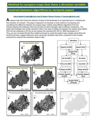
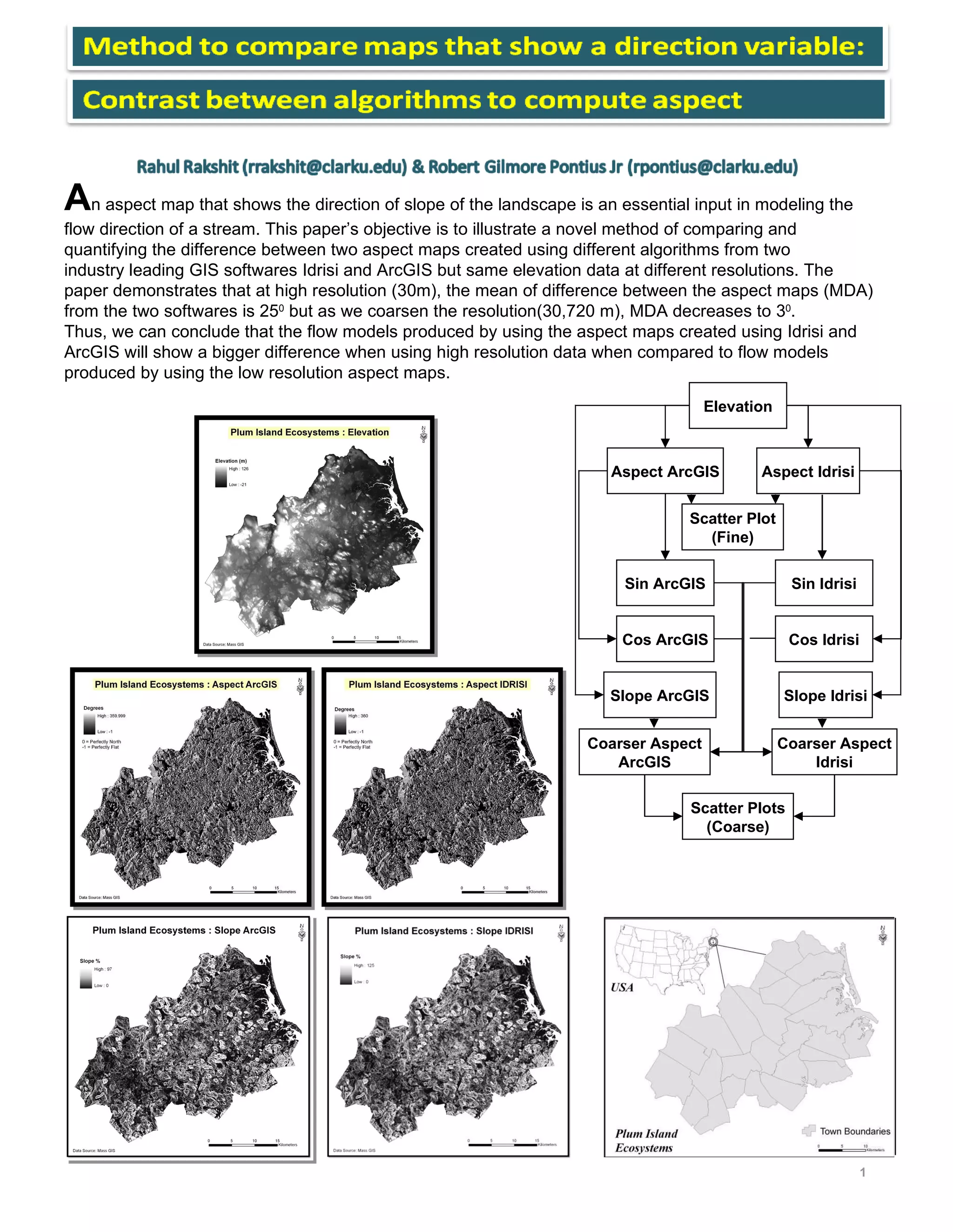
SlideShare a Scribd company logo
A n aspect map that shows the direction of slope of the landscape is an essential input in modeling the  flow direction of a stream. This paper’s objective is to illustrate a novel method of comparing and  quantifying the difference between two aspect maps created using different algorithms from two  industry leading GIS softwares Idrisi and ArcGIS but same elevation data at different resolutions. The  paper demonstrates that at high resolution (30m), the mean of difference between the aspect maps (MDA) from the two softwares is 25 0  but as we coarsen the resolution(30,720 m), MDA decreases to 3 0 . Thus, we can conclude that the flow models produced by using the aspect maps created using Idrisi and ArcGIS will show a bigger difference when using high resolution data when compared to flow models  produced by using the low resolution aspect maps. 1 Elevation Aspect ArcGIS Slope Idrisi Slope ArcGIS Aspect Idrisi Sin ArcGIS Cos ArcGIS Sin Idrisi Cos Idrisi Coarser Aspect ArcGIS Coarser Aspect Idrisi Scatter Plots (Coarse) Scatter Plot (Fine)
Vector Addition to Coarsen Pixels Resultant Vector (a+b+c+d)  = ,[object Object],[object Object],[object Object],[object Object],[object Object],2 30 m 120 m 480 m 1920 m 30720 m 7680 m Scatter Plots : X Axis: ArcGIS Aspect Values  Y Axis: Idrisi Aspect Values X ranges from 0 to 360 degrees & Y ranges from 0 to 360 degrees  Applying Slope Weightage O n the left, the Idrisi pixel is facing West with a slope of 1 0  and the ArcGIS pixel is facing East with a slope of 2 0 , on the right, the Idrisi pixel is facing West with a slope of 45 0  and the ArcGIS pixel is facing East with a slope of 70 0 . The pixel values on the right will be more important than that to the left. Slope acts as magnitude in vector addition for coarsening the pixels. Circular Variable : More than  one ways of reaching between  A & B Aspect is a Circular Variable  I f the value of a pixel in Idrisi map is 350 0  (A) and the value of a pixel in ArcGIS map is 10 0  (B) then the difference between the two pixels can be both 340 0 (Anticlockwise) and 20 0 (Clockwise).  We used the  least difference (20 0 ) : X n  = Value of a pixel in ArcGIS aspect map  Y n  = Value of a pixel in Idrisi aspect map in  D n  = Least difference in angle between X n  and Y n If X n  – Y n  <= 180  Then D n  = X n  – Y n   Else D n  = 360 – (X n  – Y n ) EndIf Sin  θ a  + Sin  θ b  + Sin  θ c  + Sin  θ d   Tan  -1 Cos  θ a  + Cos  θ b  + Cos  θ c + Cos  θ d

More Related Content

What's hot

A Visualization Application for SIAT
A Visualization Application for SIATA Visualization Application for SIAT
A Visualization Application for SIAT
Bernhard Snizek
 
Mobile mapping: Wuppertal, Germany
Mobile mapping: Wuppertal, GermanyMobile mapping: Wuppertal, Germany
Mobile mapping: Wuppertal, Germany
Tijana Susnjar
 
Quadratic graphs- features
Quadratic graphs- featuresQuadratic graphs- features
Quadratic graphs- features
NadineThomas4
 
Page separateor
Page separateorPage separateor
Page separateor
Chong Chin Pin
 
Telling Stories with Maps - Esri UK Annual Conference 2016ac
Telling Stories with Maps - Esri UK Annual Conference 2016acTelling Stories with Maps - Esri UK Annual Conference 2016ac
Telling Stories with Maps - Esri UK Annual Conference 2016ac
Esri UK
 
Remotesensingandgisapplications
RemotesensingandgisapplicationsRemotesensingandgisapplications
Remotesensingandgisapplications
imaduddin91
 
Commercializing geoinformation today
Commercializing geoinformation todayCommercializing geoinformation today
Commercializing geoinformation today
ICGCat
 
4.3 right triangle
4.3 right triangle4.3 right triangle
4.3 right triangle
Keabetswe Morweng
 
Presenter architectural bim & scan2bim
Presenter architectural bim & scan2bimPresenter architectural bim & scan2bim
Presenter architectural bim & scan2bim
Nick Blenkarn
 
Interoperability of geological data: First ICGC INSPIRE Geological Data Model
Interoperability of geological data: First ICGC INSPIRE Geological Data ModelInteroperability of geological data: First ICGC INSPIRE Geological Data Model
Interoperability of geological data: First ICGC INSPIRE Geological Data Model
ICGCat
 
Transformations in geometry
Transformations in geometryTransformations in geometry
Transformations in geometry
Michael_Mika
 
Ordnance Survey - Esri UK Annual Conference 2016
Ordnance Survey - Esri UK Annual Conference 2016Ordnance Survey - Esri UK Annual Conference 2016
Ordnance Survey - Esri UK Annual Conference 2016
Esri UK
 
Adaptation of data providers metadata to the INSPIRE requirements in Catalonia
Adaptation of data providers metadata to the INSPIRE requirements in CataloniaAdaptation of data providers metadata to the INSPIRE requirements in Catalonia
Adaptation of data providers metadata to the INSPIRE requirements in Catalonia
ICGCat
 
India's narayan-pandit[1]
India's  narayan-pandit[1]India's  narayan-pandit[1]
India's narayan-pandit[1]
Poonam Singh
 
2018 IMSM: Splicing of Multi-Scale Downscaler Air Quality Sufaces - US EPA Wo...
2018 IMSM: Splicing of Multi-Scale Downscaler Air Quality Sufaces - US EPA Wo...2018 IMSM: Splicing of Multi-Scale Downscaler Air Quality Sufaces - US EPA Wo...
2018 IMSM: Splicing of Multi-Scale Downscaler Air Quality Sufaces - US EPA Wo...
The Statistical and Applied Mathematical Sciences Institute
 
HERE - Esri UK Annual Conference 2016
HERE - Esri UK Annual Conference 2016HERE - Esri UK Annual Conference 2016
HERE - Esri UK Annual Conference 2016
Esri UK
 
ACT Science Coffee, Towards super-resolution for astronomical applications, A...
ACT Science Coffee, Towards super-resolution for astronomical applications, A...ACT Science Coffee, Towards super-resolution for astronomical applications, A...
ACT Science Coffee, Towards super-resolution for astronomical applications, A...
Advanced-Concepts-Team
 

What's hot (17)

A Visualization Application for SIAT
A Visualization Application for SIATA Visualization Application for SIAT
A Visualization Application for SIAT
 
Mobile mapping: Wuppertal, Germany
Mobile mapping: Wuppertal, GermanyMobile mapping: Wuppertal, Germany
Mobile mapping: Wuppertal, Germany
 
Quadratic graphs- features
Quadratic graphs- featuresQuadratic graphs- features
Quadratic graphs- features
 
Page separateor
Page separateorPage separateor
Page separateor
 
Telling Stories with Maps - Esri UK Annual Conference 2016ac
Telling Stories with Maps - Esri UK Annual Conference 2016acTelling Stories with Maps - Esri UK Annual Conference 2016ac
Telling Stories with Maps - Esri UK Annual Conference 2016ac
 
Remotesensingandgisapplications
RemotesensingandgisapplicationsRemotesensingandgisapplications
Remotesensingandgisapplications
 
Commercializing geoinformation today
Commercializing geoinformation todayCommercializing geoinformation today
Commercializing geoinformation today
 
4.3 right triangle
4.3 right triangle4.3 right triangle
4.3 right triangle
 
Presenter architectural bim & scan2bim
Presenter architectural bim & scan2bimPresenter architectural bim & scan2bim
Presenter architectural bim & scan2bim
 
Interoperability of geological data: First ICGC INSPIRE Geological Data Model
Interoperability of geological data: First ICGC INSPIRE Geological Data ModelInteroperability of geological data: First ICGC INSPIRE Geological Data Model
Interoperability of geological data: First ICGC INSPIRE Geological Data Model
 
Transformations in geometry
Transformations in geometryTransformations in geometry
Transformations in geometry
 
Ordnance Survey - Esri UK Annual Conference 2016
Ordnance Survey - Esri UK Annual Conference 2016Ordnance Survey - Esri UK Annual Conference 2016
Ordnance Survey - Esri UK Annual Conference 2016
 
Adaptation of data providers metadata to the INSPIRE requirements in Catalonia
Adaptation of data providers metadata to the INSPIRE requirements in CataloniaAdaptation of data providers metadata to the INSPIRE requirements in Catalonia
Adaptation of data providers metadata to the INSPIRE requirements in Catalonia
 
India's narayan-pandit[1]
India's  narayan-pandit[1]India's  narayan-pandit[1]
India's narayan-pandit[1]
 
2018 IMSM: Splicing of Multi-Scale Downscaler Air Quality Sufaces - US EPA Wo...
2018 IMSM: Splicing of Multi-Scale Downscaler Air Quality Sufaces - US EPA Wo...2018 IMSM: Splicing of Multi-Scale Downscaler Air Quality Sufaces - US EPA Wo...
2018 IMSM: Splicing of Multi-Scale Downscaler Air Quality Sufaces - US EPA Wo...
 
HERE - Esri UK Annual Conference 2016
HERE - Esri UK Annual Conference 2016HERE - Esri UK Annual Conference 2016
HERE - Esri UK Annual Conference 2016
 
ACT Science Coffee, Towards super-resolution for astronomical applications, A...
ACT Science Coffee, Towards super-resolution for astronomical applications, A...ACT Science Coffee, Towards super-resolution for astronomical applications, A...
ACT Science Coffee, Towards super-resolution for astronomical applications, A...
 

Viewers also liked

The world of virtual globes
The world of virtual globesThe world of virtual globes
The world of virtual globes
Rahul Rakshit
 
Mapping Lawns
Mapping LawnsMapping Lawns
Mapping Lawns
Rahul Rakshit
 
Effects of Deforestation
Effects of DeforestationEffects of Deforestation
Effects of Deforestation
Rahul Rakshit
 
Virtual Fieldwork
Virtual FieldworkVirtual Fieldwork
Virtual Fieldwork
Rahul Rakshit
 
Patient distribution Maps
Patient distribution MapsPatient distribution Maps
Patient distribution Maps
Rahul Rakshit
 
Health Maps
Health MapsHealth Maps
Health Maps
Rahul Rakshit
 
amazonie
amazonieamazonie
amazonie
racanelli
 
Urnieta Jasangarri
Urnieta JasangarriUrnieta Jasangarri
Urnieta Jasangarriguest2c1f1c
 
Bora bora
Bora boraBora bora
Bora bora
JullyVelandia
 
Outcome 2 3_feelings
Outcome 2 3_feelingsOutcome 2 3_feelings
Outcome 2 3_feelings
Nick Jordan
 
Вьюнская 09
Вьюнская 09Вьюнская 09
Вьюнская 09
Svetlana Bukreeva
 
Simply magic lia
Simply magic liaSimply magic lia
Simply magic lia
Lia Dumitrescu
 

Viewers also liked (13)

The world of virtual globes
The world of virtual globesThe world of virtual globes
The world of virtual globes
 
Mapping Lawns
Mapping LawnsMapping Lawns
Mapping Lawns
 
Effects of Deforestation
Effects of DeforestationEffects of Deforestation
Effects of Deforestation
 
Virtual Fieldwork
Virtual FieldworkVirtual Fieldwork
Virtual Fieldwork
 
Patient distribution Maps
Patient distribution MapsPatient distribution Maps
Patient distribution Maps
 
Mapping lawns in MA
Mapping lawns in MAMapping lawns in MA
Mapping lawns in MA
 
Health Maps
Health MapsHealth Maps
Health Maps
 
amazonie
amazonieamazonie
amazonie
 
Urnieta Jasangarri
Urnieta JasangarriUrnieta Jasangarri
Urnieta Jasangarri
 
Bora bora
Bora boraBora bora
Bora bora
 
Outcome 2 3_feelings
Outcome 2 3_feelingsOutcome 2 3_feelings
Outcome 2 3_feelings
 
Вьюнская 09
Вьюнская 09Вьюнская 09
Вьюнская 09
 
Simply magic lia
Simply magic liaSimply magic lia
Simply magic lia
 

Similar to Comparing directions

Image_processing_unit2_SPPU_Syllabus.pptx
Image_processing_unit2_SPPU_Syllabus.pptxImage_processing_unit2_SPPU_Syllabus.pptx
Image_processing_unit2_SPPU_Syllabus.pptx
Mayuri Narkhede
 
Computer graphics notes 2 tutorials duniya
Computer graphics notes 2   tutorials duniyaComputer graphics notes 2   tutorials duniya
Computer graphics notes 2 tutorials duniya
TutorialsDuniya.com
 
EFFECTIVE INTEREST REGION ESTIMATION MODEL TO REPRESENT CORNERS FOR IMAGE
EFFECTIVE INTEREST REGION ESTIMATION MODEL TO REPRESENT CORNERS FOR IMAGE EFFECTIVE INTEREST REGION ESTIMATION MODEL TO REPRESENT CORNERS FOR IMAGE
EFFECTIVE INTEREST REGION ESTIMATION MODEL TO REPRESENT CORNERS FOR IMAGE
sipij
 
A STUDY AND ANALYSIS OF DIFFERENT EDGE DETECTION TECHNIQUES
A STUDY AND ANALYSIS OF DIFFERENT EDGE DETECTION TECHNIQUESA STUDY AND ANALYSIS OF DIFFERENT EDGE DETECTION TECHNIQUES
A STUDY AND ANALYSIS OF DIFFERENT EDGE DETECTION TECHNIQUES
cscpconf
 
03.Scan Conversion.ppt
03.Scan Conversion.ppt03.Scan Conversion.ppt
03.Scan Conversion.ppt
RobinAhmedSaikat
 
B. SC CSIT Computer Graphics Unit1.2 By Tekendra Nath Yogi
B. SC CSIT Computer Graphics Unit1.2 By Tekendra Nath YogiB. SC CSIT Computer Graphics Unit1.2 By Tekendra Nath Yogi
B. SC CSIT Computer Graphics Unit1.2 By Tekendra Nath Yogi
Tekendra Nath Yogi
 
Bresenham circlesandpolygons
Bresenham circlesandpolygonsBresenham circlesandpolygons
Bresenham circlesandpolygons
aa11bb11
 
Bresenham circles and polygons derication
Bresenham circles and polygons dericationBresenham circles and polygons derication
Bresenham circles and polygons derication
Kumar
 
PART I.3 - Physical Mathematics
PART I.3 - Physical MathematicsPART I.3 - Physical Mathematics
PART I.3 - Physical Mathematics
Maurice R. TREMBLAY
 
3-1_geo Spatial analysis_spatial_modeling.pptx
3-1_geo Spatial analysis_spatial_modeling.pptx3-1_geo Spatial analysis_spatial_modeling.pptx
3-1_geo Spatial analysis_spatial_modeling.pptx
Ashwini Rao
 
IJERD (www.ijerd.com) International Journal of Engineering Research and Devel...
IJERD (www.ijerd.com) International Journal of Engineering Research and Devel...IJERD (www.ijerd.com) International Journal of Engineering Research and Devel...
IJERD (www.ijerd.com) International Journal of Engineering Research and Devel...
IJERD Editor
 
Content Based Image Retrieval Using Gray Level Co-Occurance Matrix with SVD a...
Content Based Image Retrieval Using Gray Level Co-Occurance Matrix with SVD a...Content Based Image Retrieval Using Gray Level Co-Occurance Matrix with SVD a...
Content Based Image Retrieval Using Gray Level Co-Occurance Matrix with SVD a...
ijcisjournal
 
Algorithm
AlgorithmAlgorithm
Algorithm
Pragnesh Patel
 
Computer graphics
Computer graphicsComputer graphics
Computer graphics
Diksha Trivedi
 
Dense Visual Odometry Using Genetic Algorithm
Dense Visual Odometry Using Genetic AlgorithmDense Visual Odometry Using Genetic Algorithm
Dense Visual Odometry Using Genetic Algorithm
Slimane Djema
 
Scaling Transform Methods For Compressing a 2D Graphical image
Scaling Transform Methods For Compressing a 2D Graphical image Scaling Transform Methods For Compressing a 2D Graphical image
Scaling Transform Methods For Compressing a 2D Graphical image
acijjournal
 
Chapter 2 1
Chapter 2 1Chapter 2 1
Chapter 2 1
abadi saied
 
Vf sift
Vf siftVf sift
Vf sift
e_mirsadeghi
 
MAP MAKING FROM TABLES
MAP MAKING FROM TABLESMAP MAKING FROM TABLES
MAP MAKING FROM TABLES
ijcga
 
MAP MAKING FROM TABLES
MAP MAKING FROM TABLESMAP MAKING FROM TABLES
MAP MAKING FROM TABLES
ijcga
 

Similar to Comparing directions (20)

Image_processing_unit2_SPPU_Syllabus.pptx
Image_processing_unit2_SPPU_Syllabus.pptxImage_processing_unit2_SPPU_Syllabus.pptx
Image_processing_unit2_SPPU_Syllabus.pptx
 
Computer graphics notes 2 tutorials duniya
Computer graphics notes 2   tutorials duniyaComputer graphics notes 2   tutorials duniya
Computer graphics notes 2 tutorials duniya
 
EFFECTIVE INTEREST REGION ESTIMATION MODEL TO REPRESENT CORNERS FOR IMAGE
EFFECTIVE INTEREST REGION ESTIMATION MODEL TO REPRESENT CORNERS FOR IMAGE EFFECTIVE INTEREST REGION ESTIMATION MODEL TO REPRESENT CORNERS FOR IMAGE
EFFECTIVE INTEREST REGION ESTIMATION MODEL TO REPRESENT CORNERS FOR IMAGE
 
A STUDY AND ANALYSIS OF DIFFERENT EDGE DETECTION TECHNIQUES
A STUDY AND ANALYSIS OF DIFFERENT EDGE DETECTION TECHNIQUESA STUDY AND ANALYSIS OF DIFFERENT EDGE DETECTION TECHNIQUES
A STUDY AND ANALYSIS OF DIFFERENT EDGE DETECTION TECHNIQUES
 
03.Scan Conversion.ppt
03.Scan Conversion.ppt03.Scan Conversion.ppt
03.Scan Conversion.ppt
 
B. SC CSIT Computer Graphics Unit1.2 By Tekendra Nath Yogi
B. SC CSIT Computer Graphics Unit1.2 By Tekendra Nath YogiB. SC CSIT Computer Graphics Unit1.2 By Tekendra Nath Yogi
B. SC CSIT Computer Graphics Unit1.2 By Tekendra Nath Yogi
 
Bresenham circlesandpolygons
Bresenham circlesandpolygonsBresenham circlesandpolygons
Bresenham circlesandpolygons
 
Bresenham circles and polygons derication
Bresenham circles and polygons dericationBresenham circles and polygons derication
Bresenham circles and polygons derication
 
PART I.3 - Physical Mathematics
PART I.3 - Physical MathematicsPART I.3 - Physical Mathematics
PART I.3 - Physical Mathematics
 
3-1_geo Spatial analysis_spatial_modeling.pptx
3-1_geo Spatial analysis_spatial_modeling.pptx3-1_geo Spatial analysis_spatial_modeling.pptx
3-1_geo Spatial analysis_spatial_modeling.pptx
 
IJERD (www.ijerd.com) International Journal of Engineering Research and Devel...
IJERD (www.ijerd.com) International Journal of Engineering Research and Devel...IJERD (www.ijerd.com) International Journal of Engineering Research and Devel...
IJERD (www.ijerd.com) International Journal of Engineering Research and Devel...
 
Content Based Image Retrieval Using Gray Level Co-Occurance Matrix with SVD a...
Content Based Image Retrieval Using Gray Level Co-Occurance Matrix with SVD a...Content Based Image Retrieval Using Gray Level Co-Occurance Matrix with SVD a...
Content Based Image Retrieval Using Gray Level Co-Occurance Matrix with SVD a...
 
Algorithm
AlgorithmAlgorithm
Algorithm
 
Computer graphics
Computer graphicsComputer graphics
Computer graphics
 
Dense Visual Odometry Using Genetic Algorithm
Dense Visual Odometry Using Genetic AlgorithmDense Visual Odometry Using Genetic Algorithm
Dense Visual Odometry Using Genetic Algorithm
 
Scaling Transform Methods For Compressing a 2D Graphical image
Scaling Transform Methods For Compressing a 2D Graphical image Scaling Transform Methods For Compressing a 2D Graphical image
Scaling Transform Methods For Compressing a 2D Graphical image
 
Chapter 2 1
Chapter 2 1Chapter 2 1
Chapter 2 1
 
Vf sift
Vf siftVf sift
Vf sift
 
MAP MAKING FROM TABLES
MAP MAKING FROM TABLESMAP MAKING FROM TABLES
MAP MAKING FROM TABLES
 
MAP MAKING FROM TABLES
MAP MAKING FROM TABLESMAP MAKING FROM TABLES
MAP MAKING FROM TABLES
 

More from Rahul Rakshit

holmes
holmesholmes
Site Suitability Analysis
Site Suitability AnalysisSite Suitability Analysis
Site Suitability Analysis
Rahul Rakshit
 
Comparing directional maps
Comparing directional mapsComparing directional maps
Comparing directional maps
Rahul Rakshit
 
Post Accuracy Assessment Classification
Post Accuracy Assessment ClassificationPost Accuracy Assessment Classification
Post Accuracy Assessment Classification
Rahul Rakshit
 
Segmentation scale selection
Segmentation scale selectionSegmentation scale selection
Segmentation scale selection
Rahul Rakshit
 
OBIA accuracy survey
OBIA accuracy surveyOBIA accuracy survey
OBIA accuracy survey
Rahul Rakshit
 

More from Rahul Rakshit (6)

holmes
holmesholmes
holmes
 
Site Suitability Analysis
Site Suitability AnalysisSite Suitability Analysis
Site Suitability Analysis
 
Comparing directional maps
Comparing directional mapsComparing directional maps
Comparing directional maps
 
Post Accuracy Assessment Classification
Post Accuracy Assessment ClassificationPost Accuracy Assessment Classification
Post Accuracy Assessment Classification
 
Segmentation scale selection
Segmentation scale selectionSegmentation scale selection
Segmentation scale selection
 
OBIA accuracy survey
OBIA accuracy surveyOBIA accuracy survey
OBIA accuracy survey
 

Recently uploaded

Your One-Stop Shop for Python Success: Top 10 US Python Development Providers
Your One-Stop Shop for Python Success: Top 10 US Python Development ProvidersYour One-Stop Shop for Python Success: Top 10 US Python Development Providers
Your One-Stop Shop for Python Success: Top 10 US Python Development Providers
akankshawande
 
Columbus Data & Analytics Wednesdays - June 2024
Columbus Data & Analytics Wednesdays - June 2024Columbus Data & Analytics Wednesdays - June 2024
Columbus Data & Analytics Wednesdays - June 2024
Jason Packer
 
“Temporal Event Neural Networks: A More Efficient Alternative to the Transfor...
“Temporal Event Neural Networks: A More Efficient Alternative to the Transfor...“Temporal Event Neural Networks: A More Efficient Alternative to the Transfor...
“Temporal Event Neural Networks: A More Efficient Alternative to the Transfor...
Edge AI and Vision Alliance
 
Astute Business Solutions | Oracle Cloud Partner |
Astute Business Solutions | Oracle Cloud Partner |Astute Business Solutions | Oracle Cloud Partner |
Astute Business Solutions | Oracle Cloud Partner |
AstuteBusiness
 
Monitoring and Managing Anomaly Detection on OpenShift.pdf
Monitoring and Managing Anomaly Detection on OpenShift.pdfMonitoring and Managing Anomaly Detection on OpenShift.pdf
Monitoring and Managing Anomaly Detection on OpenShift.pdf
Tosin Akinosho
 
Essentials of Automations: Exploring Attributes & Automation Parameters
Essentials of Automations: Exploring Attributes & Automation ParametersEssentials of Automations: Exploring Attributes & Automation Parameters
Essentials of Automations: Exploring Attributes & Automation Parameters
Safe Software
 
Apps Break Data
Apps Break DataApps Break Data
Apps Break Data
Ivo Velitchkov
 
How to Interpret Trends in the Kalyan Rajdhani Mix Chart.pdf
How to Interpret Trends in the Kalyan Rajdhani Mix Chart.pdfHow to Interpret Trends in the Kalyan Rajdhani Mix Chart.pdf
How to Interpret Trends in the Kalyan Rajdhani Mix Chart.pdf
Chart Kalyan
 
Northern Engraving | Nameplate Manufacturing Process - 2024
Northern Engraving | Nameplate Manufacturing Process - 2024Northern Engraving | Nameplate Manufacturing Process - 2024
Northern Engraving | Nameplate Manufacturing Process - 2024
Northern Engraving
 
Leveraging the Graph for Clinical Trials and Standards
Leveraging the Graph for Clinical Trials and StandardsLeveraging the Graph for Clinical Trials and Standards
Leveraging the Graph for Clinical Trials and Standards
Neo4j
 
Introduction of Cybersecurity with OSS at Code Europe 2024
Introduction of Cybersecurity with OSS  at Code Europe 2024Introduction of Cybersecurity with OSS  at Code Europe 2024
Introduction of Cybersecurity with OSS at Code Europe 2024
Hiroshi SHIBATA
 
June Patch Tuesday
June Patch TuesdayJune Patch Tuesday
June Patch Tuesday
Ivanti
 
The Microsoft 365 Migration Tutorial For Beginner.pptx
The Microsoft 365 Migration Tutorial For Beginner.pptxThe Microsoft 365 Migration Tutorial For Beginner.pptx
The Microsoft 365 Migration Tutorial For Beginner.pptx
operationspcvita
 
What is an RPA CoE? Session 1 – CoE Vision
What is an RPA CoE?  Session 1 – CoE VisionWhat is an RPA CoE?  Session 1 – CoE Vision
What is an RPA CoE? Session 1 – CoE Vision
DianaGray10
 
Fueling AI with Great Data with Airbyte Webinar
Fueling AI with Great Data with Airbyte WebinarFueling AI with Great Data with Airbyte Webinar
Fueling AI with Great Data with Airbyte Webinar
Zilliz
 
"Choosing proper type of scaling", Olena Syrota
"Choosing proper type of scaling", Olena Syrota"Choosing proper type of scaling", Olena Syrota
"Choosing proper type of scaling", Olena Syrota
Fwdays
 
Harnessing the Power of NLP and Knowledge Graphs for Opioid Research
Harnessing the Power of NLP and Knowledge Graphs for Opioid ResearchHarnessing the Power of NLP and Knowledge Graphs for Opioid Research
Harnessing the Power of NLP and Knowledge Graphs for Opioid Research
Neo4j
 
Mutation Testing for Task-Oriented Chatbots
Mutation Testing for Task-Oriented ChatbotsMutation Testing for Task-Oriented Chatbots
Mutation Testing for Task-Oriented Chatbots
Pablo Gómez Abajo
 
Programming Foundation Models with DSPy - Meetup Slides
Programming Foundation Models with DSPy - Meetup SlidesProgramming Foundation Models with DSPy - Meetup Slides
Programming Foundation Models with DSPy - Meetup Slides
Zilliz
 
GNSS spoofing via SDR (Criptored Talks 2024)
GNSS spoofing via SDR (Criptored Talks 2024)GNSS spoofing via SDR (Criptored Talks 2024)
GNSS spoofing via SDR (Criptored Talks 2024)
Javier Junquera
 

Recently uploaded (20)

Your One-Stop Shop for Python Success: Top 10 US Python Development Providers
Your One-Stop Shop for Python Success: Top 10 US Python Development ProvidersYour One-Stop Shop for Python Success: Top 10 US Python Development Providers
Your One-Stop Shop for Python Success: Top 10 US Python Development Providers
 
Columbus Data & Analytics Wednesdays - June 2024
Columbus Data & Analytics Wednesdays - June 2024Columbus Data & Analytics Wednesdays - June 2024
Columbus Data & Analytics Wednesdays - June 2024
 
“Temporal Event Neural Networks: A More Efficient Alternative to the Transfor...
“Temporal Event Neural Networks: A More Efficient Alternative to the Transfor...“Temporal Event Neural Networks: A More Efficient Alternative to the Transfor...
“Temporal Event Neural Networks: A More Efficient Alternative to the Transfor...
 
Astute Business Solutions | Oracle Cloud Partner |
Astute Business Solutions | Oracle Cloud Partner |Astute Business Solutions | Oracle Cloud Partner |
Astute Business Solutions | Oracle Cloud Partner |
 
Monitoring and Managing Anomaly Detection on OpenShift.pdf
Monitoring and Managing Anomaly Detection on OpenShift.pdfMonitoring and Managing Anomaly Detection on OpenShift.pdf
Monitoring and Managing Anomaly Detection on OpenShift.pdf
 
Essentials of Automations: Exploring Attributes & Automation Parameters
Essentials of Automations: Exploring Attributes & Automation ParametersEssentials of Automations: Exploring Attributes & Automation Parameters
Essentials of Automations: Exploring Attributes & Automation Parameters
 
Apps Break Data
Apps Break DataApps Break Data
Apps Break Data
 
How to Interpret Trends in the Kalyan Rajdhani Mix Chart.pdf
How to Interpret Trends in the Kalyan Rajdhani Mix Chart.pdfHow to Interpret Trends in the Kalyan Rajdhani Mix Chart.pdf
How to Interpret Trends in the Kalyan Rajdhani Mix Chart.pdf
 
Northern Engraving | Nameplate Manufacturing Process - 2024
Northern Engraving | Nameplate Manufacturing Process - 2024Northern Engraving | Nameplate Manufacturing Process - 2024
Northern Engraving | Nameplate Manufacturing Process - 2024
 
Leveraging the Graph for Clinical Trials and Standards
Leveraging the Graph for Clinical Trials and StandardsLeveraging the Graph for Clinical Trials and Standards
Leveraging the Graph for Clinical Trials and Standards
 
Introduction of Cybersecurity with OSS at Code Europe 2024
Introduction of Cybersecurity with OSS  at Code Europe 2024Introduction of Cybersecurity with OSS  at Code Europe 2024
Introduction of Cybersecurity with OSS at Code Europe 2024
 
June Patch Tuesday
June Patch TuesdayJune Patch Tuesday
June Patch Tuesday
 
The Microsoft 365 Migration Tutorial For Beginner.pptx
The Microsoft 365 Migration Tutorial For Beginner.pptxThe Microsoft 365 Migration Tutorial For Beginner.pptx
The Microsoft 365 Migration Tutorial For Beginner.pptx
 
What is an RPA CoE? Session 1 – CoE Vision
What is an RPA CoE?  Session 1 – CoE VisionWhat is an RPA CoE?  Session 1 – CoE Vision
What is an RPA CoE? Session 1 – CoE Vision
 
Fueling AI with Great Data with Airbyte Webinar
Fueling AI with Great Data with Airbyte WebinarFueling AI with Great Data with Airbyte Webinar
Fueling AI with Great Data with Airbyte Webinar
 
"Choosing proper type of scaling", Olena Syrota
"Choosing proper type of scaling", Olena Syrota"Choosing proper type of scaling", Olena Syrota
"Choosing proper type of scaling", Olena Syrota
 
Harnessing the Power of NLP and Knowledge Graphs for Opioid Research
Harnessing the Power of NLP and Knowledge Graphs for Opioid ResearchHarnessing the Power of NLP and Knowledge Graphs for Opioid Research
Harnessing the Power of NLP and Knowledge Graphs for Opioid Research
 
Mutation Testing for Task-Oriented Chatbots
Mutation Testing for Task-Oriented ChatbotsMutation Testing for Task-Oriented Chatbots
Mutation Testing for Task-Oriented Chatbots
 
Programming Foundation Models with DSPy - Meetup Slides
Programming Foundation Models with DSPy - Meetup SlidesProgramming Foundation Models with DSPy - Meetup Slides
Programming Foundation Models with DSPy - Meetup Slides
 
GNSS spoofing via SDR (Criptored Talks 2024)
GNSS spoofing via SDR (Criptored Talks 2024)GNSS spoofing via SDR (Criptored Talks 2024)
GNSS spoofing via SDR (Criptored Talks 2024)
 

Comparing directions

  • 1. A n aspect map that shows the direction of slope of the landscape is an essential input in modeling the flow direction of a stream. This paper’s objective is to illustrate a novel method of comparing and quantifying the difference between two aspect maps created using different algorithms from two industry leading GIS softwares Idrisi and ArcGIS but same elevation data at different resolutions. The paper demonstrates that at high resolution (30m), the mean of difference between the aspect maps (MDA) from the two softwares is 25 0 but as we coarsen the resolution(30,720 m), MDA decreases to 3 0 . Thus, we can conclude that the flow models produced by using the aspect maps created using Idrisi and ArcGIS will show a bigger difference when using high resolution data when compared to flow models produced by using the low resolution aspect maps. 1 Elevation Aspect ArcGIS Slope Idrisi Slope ArcGIS Aspect Idrisi Sin ArcGIS Cos ArcGIS Sin Idrisi Cos Idrisi Coarser Aspect ArcGIS Coarser Aspect Idrisi Scatter Plots (Coarse) Scatter Plot (Fine)
  • 2.