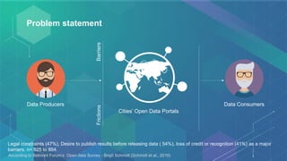
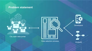
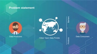
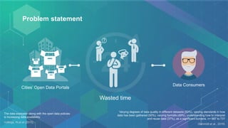
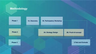
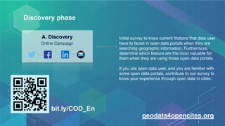
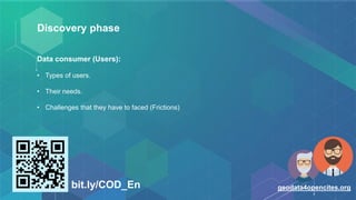
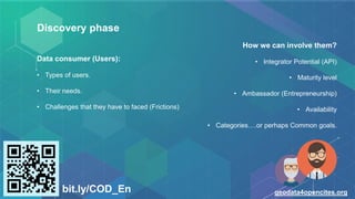
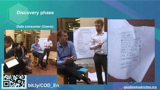
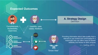
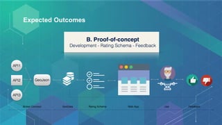
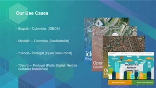
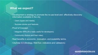
This document discusses the CityData 3.0 initiative, which aims to reduce barriers and friction that users experience when searching for and accessing geographic data on cities' open data portals. The methodology involves an initial discovery phase to understand user needs and challenges through a survey. Expected outcomes include developing strategies and a web tool to promote greater reuse and discovery of cities' open data, integrating APIs to make data more accessible to developers, and identifying success stories and key features. The initiative will work with several cities to test concepts and gather feedback to improve data quality, usability, and user experiences of open data portals.
2. Agenda
• What is Geo-C: Enabling Open Cities Project?
• What is initiative CityData 3.0?
• Methodology
• Expected outcomes
• Campaign to know the re-use and discovery level of cities open data portals
current status.
• Conclusions.
3. GeoC: Enabling Open Cities project
http://geo-c.eu/
http://giv-oct.uni-muenster.de:5000/http://giv-oct.uni-muenster.de:5000/
@geoC_EU
4. Geo-C: Enabling Open Cities
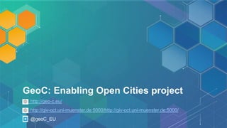
• Project faced by a consortium of three universities is supported by a network of associated partners,
which are city councils and companies in Germany, Spain, and Portugal. An international Advisory Board.
• The main goal of GEO-C is to make substantial scientific progress towards the notion of open cities, i.e.
smart cities that are open to all citizens and facilitate participation on all levels.
• Using three core areas in research on open governance: participation, collaboration, transparency [1].
Each strand falls into one of the intersections between the core areas and covers a crucially important
aspect for realising open cities: deep participation, analysis and fusion of city data, and city services.
5. Esr 11: Multi-scale, multidimensional urban information integration,
matching and visualization.
• Contribute to overcome the problem of having several geodata sources and sensors that
have disparate resolutions (both spatial and temporal) which need to be allied together in
order to extract useful knowledge doing analyses and to display the outcome in a variety of
devices, including traditional screens as well as current and coming displays and interaction
devices as AR and wearable technologies.
7. Some facts…
Open Data portals: 2,694according OpenDataSoft.com
Cities’ open data portals: ?
Number of Datasets, only in Europe: 637,883 datasets
Number of Cities’ Open Data Datasets: ?
Facts http://www.europeandataportal.eu/, consulted 22 Oct 2016
http://opendatabarometer.org
http://census.okfn.org
http://www.opendatamonitor.eu/frontend/web/index.php
http://checklists.opquast.com/en/opendata
http://metadata-census.com
8. Problem statement
Data Producers Data Consumers
BarriersFrictions
Cities’ Open Data Portals
Legal constraints (47%), Desire to publish results before releasing data ( 54%), loss of credit or recognition (41%) as a major
barriers. n= 825 to 854.
According to Belmont Forum’s Open data Survey - Brigit Schmidt (Schmidt et al., 2016)
11. Problem statement
Data Consumers
Cities’ Open Data Portals
Wasted time
Varying degrees of data quality in different datasets (53%), varying standards in how
data has been gathered (50%), varying formats (49%), understanding how to interpret
and reuse data (37%), as a significant burdens. n= 687 to 731
(Schmidt et al., 2016)
The data explosion along with the open data policies
is increasing data availability.
Vullings, W,et al (2015)
12. Problem statement
Open Government data not only support transparency of the governments but its reuse in products and services can result in economic
benefits
Vickery, G. et al (2011)
15. Discovery phase
Initial survey to know current frictions that data user
have to faced in open data portals when they are
searching geographic information. Furthermore,
determine which feature are the most valuable for
them when they are using those open data portals.
If you are open data user, and you are familiar with
some open data portals, contribute to our survey to
know your experience through open data in cities
bit.ly/COD_En
geodata4opencites.org
16. Discovery phase
Data consumer (Users):
• Types of users.
• Their needs.
• Challenges that they have to faced (Frictions)
bit.ly/COD_En geodata4opencites.org
17. Discovery phase
Data consumer (Users):
• Types of users.
• Their needs.
• Challenges that they have to faced (Frictions)
bit.ly/COD_En geodata4opencites.org
How we can involve them?
• Integrator Potential (API)
• Maturity level
• Ambassador (Entrepreneurship)
• Availability
• Categories….or perhaps Common goals.
18. Discovery phase
Data consumer (Users):
• Types of users.
• Their needs.
• Challenges that they have to faced (Frictions)
bit.ly/COD_En geodata4opencites.org
How we can involve them?
• Integrator Potential (API)
• Maturity level
• Ambassador (Entrepreneurship)
• Availability
• Categories….or perhaps Common goals.
19. Discovery phase
Data consumer (Users):
• Types of users.
• Their needs.
• Challenges that they have to faced (Frictions)
bit.ly/COD_En geodata4opencites.org
How we can involve them?
• Integrator Potential (API)
• Maturity level
• Ambassador (Entrepreneurship)
• Availability
• Categories….or perhaps Common goals.
20. Discovery phase
Data consumer (Users):
• Types of users.
• Their needs.
• Challenges that they have to faced (Frictions)
bit.ly/COD_En geodata4opencites.org
How we can involve them?
• Integrator Potential (API)
• Maturity level
• Ambassador (Entrepreneurship)
• Availability
• Categories….or perhaps Common goals.
21. Expected Outcomes
Completeness,
Accessibility,
Openness
Usability, uses
cases, feedback
RatingSchema
“Drone View”
RatingSchema
Providing information about data quality that is
relevant to use context and commutated in a
meaningful way can allow users to assess
reliability and fitness for their propose
J. L. Harding. (2013)
24. Our Use Cases
• Bogotá – Colombia (IDECA)
• Medellin – Colombia (GeoMedellin)
• *Lisbon– Portugal (Open Data Portal)
• *Oporto – Portugal (Porto Digital, Red de
ciudades brasileñas)
25. What we expect?
• Development a strategy to promote the re-use level and effectively discovery
information available in the city.
• Users (types and needs).
• Success stories and features.
• Proof of Concept:
• Integrator APIs (If is really useful for developers)
• Community (Actors and their roles)
• Real benefits in economic, innovation, and scalability terms.
• CityData 3.0 (Strategy, WebTool, indicators and validators)
geodata4opencites.org
27. References
[1] Degbelo, A., Granell, C., Trilles, S., Bhattacharya, D., Casteleyn, S., & Kray, C. (2016). Opening up
Smart Cities: Citizen-Centric Challenges and Opportunities from GIScience. ISPRS International
Journal of Geo-Information, 5(2), 16. http://doi.org/10.3390/ijgi5020016
[2] Schmidt, B., Gemeinholzer, B., Treloar, A., Tenopir, C., Allard, S., Douglass, K., … Bendix, J.
(2016). Open Data in Global Environmental Research: The Belmont Forum’s Open Data Survey.
PLOS ONE, 11(1), e0146695. http://doi.org/10.1371/journal.pone.0146695
[3] Jan Kučera, Dušan Chlapek, and M. N. (2013). Open Government Data Catalogs: Current
Approaches and Quality Perspective. (A. Kő, C. Leitner, H. Leitold, & A. Prosser, Eds.) (Vol. 8061).
Berlin, Heidelberg: Springer Berlin Heidelberg. http://doi.org/10.1007/978-3-642-40160-2
[4] Vullings, W., & Wageningen; Jandirk; Frans I. Rip; Martijn Boss. (2015). Spatial Data Quality: What
do you mean? Retrieved April 4, 2016, from https://agile-
online.org/Conference_Paper/cds/agile_2015/shortpapers/87/87_Paper_in_PDF.pdf
[5] J. L. Harding. (2013). DATA QUALITY IN THE INTEGRATION AND ANALYSIS OF DATA FROM
MULTIPLE SOURCES: SOME RESEARCH CHALLENGES. Retrieved March 23, 2016, from
http://www.int-arch-photogramm-remote-sens-spatial-inf-sci.net/XL-2-W1/59/2013/isprsarchives-XL-2-
W1-59-2013.pdf
28. Thanks you very much for your attention.
Any doubts or comments?
Fernando Benitez
benitezm@uji.es
@mfbenitez