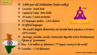
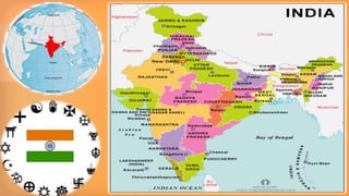
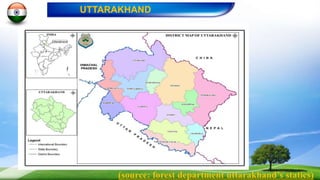
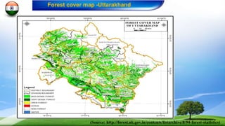
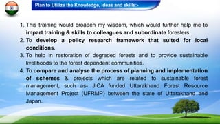
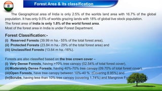
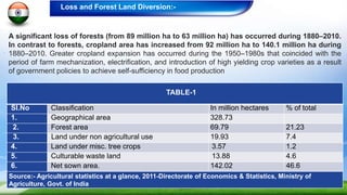
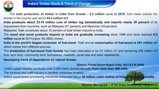
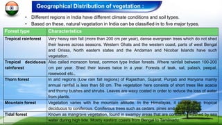
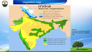
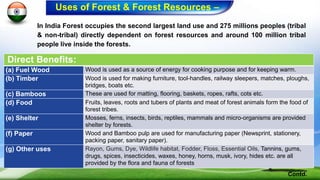
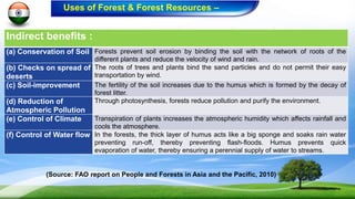
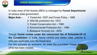
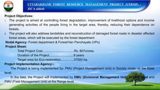
WELCOME/ Swaagatam
ようこそ/ Yōkoso
Development of Forest Management Scheme in Harmony with
Environment in the Tropical /
Sub-Tropical Area
By :
Dharm Singh Meena, IFS
Department of Forests, Govt. of Uttarakhand,
INDIA - 248001
Presentation Outlines…….
 About India…
 Profile of Uttarakhand
 Map of Uttarakhand
 Forest Cover map of Uttarakhand
 Expectations of the Program
 Current status of India’s Forests
 Forest & Other Land Uses of India
 India’s Timber Stock & Trends
 Forest/ Vegetation Distribution
 India’s Forest Map
 Major use and users of Forest
 Government Agency Responsible for Forest Management
 JICA aided – UFRM Project
 Conclusion - Problems/Issues to be address
 Bibliography
India - a Diverse Nation…
India is a picture of diversity - seen in her people,
cultures, colorful festivals, dresses and costumes,
religions, flora and fauna and varying landscapes.
About:…
 5,000 year old civilization (Indus valley)
 Location: South Asia
 Capital of India: New Delhi
 29 states, 7 union territories
 325 languages spoken – 1,652 dialects
 18 official languages
 The world's largest democracy and second most populous (1.28 billion
(2015) country
 Sovereign, Socialist, Secular, Democratic Republic with a Parliamentary
system of Government.
 Area - 3.28 million sq. kilometers ( 7th largest country in the world)
 Coastline – 7,516 kilometers
(Source: http://indiagov.in)
About…
yoga
COLOURS OF INDIA
Many Religions :
Bahai Lotus Temple-Delhi
St. Paul's Cathedral-TN
Jama Mosque-Delhi
Boddh Gaya-Bihar
Golden TempleJewish Synagogue
Akshardham Temple
I Historical Monuments
Sanchi-Madhya-Pradesh
Hawa mahal -Jaipur
The Taj mahal -Agra
Banaglore palace
India gate
The Sun temple
Cultural Diversity
Diverse People Diverse Food
Modern India
An IT Park in Hyderabad
Bangalore Gaurgaon
An IT Firm - Bangalore Noida
Hyderabad
Bio-Diversity
Sl.no. Organism Species Number
1. Flowering Plants 15,000 (33% endemic) – 12 % of the world
2. Mammals 423 (44 spp. endemic)
3. Birds 1331 (55 spp. endemic)
4. Reptiles 408
5. Fishes 2546
6. Amphibians 200
 18 mega-diverse nations of the world.
 Forest area – 69 .79 Million Hectares (21.23 %) .
 However, National forest policy aims at 33%.
 National Parks -103
 Wild Life Sanctuaries – 506
 Tiger reserves - 48
 Biodiversity hotspots- i. Western Ghats and ii. The East Himalayan region.
 50,000 varieties of rice (the biggest reservoir of rice on Earth).
Source: http://wii.gov.in/search/content/national%20parks
Some random photographs - Biodiversity
National Tree- Banyan
National animal – the Bengal Tiger National Bird – The Peacock
National flower - Nelumbo
Saras crane
One Horn Rhinoceros
Pit Viper Nanda Devi Peak Asiatic Lion
Asiatic ElephantValley of FlowersCommon Kingfisher
Some random photographs - Biodiversity
(source: forest department uttarakhand’s statics)
UTTARAKHAND
(Source: http://forest.uk.gov.in/contents/listarchive/8/94-forest-statistics)
Forest cover map -Uttarakhand
An Indian state in the Himalayas, fragile ecology susceptible/prone to natural
disasters (Earth quick, landslide, forest fire and avalanches).
Profile of Uttarakhand:-
1. Total Geographical area 53483 Sq Km.
2. Area under Forests 34651 Sq Km. (65%)
3. No of Districts 13
4. No. of Villages 16826
5. No. of Van Panchyats 12086
6. Total census population (2011) 10 million (75% is Rural)
7. No. of Protected Areas (12% of Geo. Area.) NP-6 , WLS-7, CR-5 & BR-1
8. Major Rivers Ganga, Yamuna,Tons, Shardas,
Bhagirathi, Pindar etc.
9. Major Forest Types 1. Himalayan Conifers- Pines
2.Alpine & Sub-alpine
3. Himalayan Broad Leaf Forest
4. Sal & Teak Forest
5. Oak Forests
(Source: FSI &Uttarakhnadstat.Com)
Kind of Knowledge and Skills want to acquire through this training program:
1. To have a developed scheme for development vis a vis conservation.
2. Growing demand for timber, fuel wood and fodder is putting enormous pressure on the
forest resources of our state. Of the total 16,826 villages in the state, 12,089 (van
panchyats) are located in the vicinity of forest areas. Around 60 lakh people are dependent
on forests. A large population of the state cattle is dependent on forests. Therefore, it is
required to evolve such a Scheme of Sustainable Forest Management, which can
harmonize with local environment and help in sustaining the livelihoods of local
communities.
3. The destruction and degradation of forests are taking a heavy toll on soil and water
resources, making the land less productive and leading to natural calamities and
impoverishment of the rural population in this Himalayan state of Uttarakhand. Therefore, a
collective scheme is desired in order to restore these degraded forest lands.
4. To develop an innovative surveying and demarcation scheme for these forest areas.
1. This training would broaden my wisdom, which would further help me to
impart training & skills to colleagues and subordinate foresters.
2. To develop a policy research framework that suited for local
conditions.
3. To help in restoration of degraded forests and to provide sustainable
livelihoods to the forest dependent communities.
4. To compare and analyse the process of planning and implementation
of schemes & projects which are related to sustainable forest
management, such as- JICA funded Uttarakhand Forest Resource
Management Project (UFRMP) between the state of Uttarakhand and
Japan.
Plan to Utilize the Knowledge, ideas and skills:-
The Geographical area of India is only 2.5% of the worlds land area with 16.7% of the global
population. It has only 0.5% of worlds grazing lands with 18% of global live stock population.
The forest area of India is only 1.8% of the world forest area.
Most of the forest area in India is under Forest Department.
Forest Classification:-
(i) Reserved Forests (39.99 m ha.- 55% of the total forest area),
(ii) Protected Forests (23.84 m ha.- 29% of the total forest area) and
(iii) Unclassified Forests (13.64 m ha.-16%).
Forests are also classified based on the tree crown cover –
(i) Very Dense Forests, having >70% tree canopy (02.54% of total forest cover),
(ii)Moderately Dense Forests, having 40%-70% tree canopy (09.70% of total forest cover),
(iii)Open Forests, have tree canopy between 10%-40 %. (Covering 8.95%) and
(iv)Scrubs, having less than 10% tree canopy (covering 1.74%) and Mangrove Forests (0.15%).
Forest Area & its classification
A significant loss of forests (from 89 million ha to 63 million ha) has occurred during 1880–2010.
In contrast to forests, cropland area has increased from 92 million ha to 140.1 million ha during
1880–2010. Greater cropland expansion has occurred during the 1950–1980s that coincided with the
period of farm mechanization, electrification, and introduction of high yielding crop varieties as a result
of government policies to achieve self-sufficiency in food production
Loss and Forest Land Diversion:-
TABLE-1
Sl.No Classification In million hectares % of total
1. Geographical area 328.73
2. Forest area 69.79 21.23
3. Land under non agricultural use 19.93 7.4
4. Land under misc. tree crops 3.57 1.2
5. Culturable waste land 13.88 4.6
6. Net sown area. 142.02 46.6
Source:- Agricultural statistics at a glance, 2011-Directorate of Economics & Statistics, Ministry of
Agriculture, Govt. of India
The total production of timber in India from forests - 2.3 million cu.m in 2010, from trees outside the
forests in the country was about 44.3 million m3.
India produces about 23.19 million cum of timber log domestically and imports nearly 20 percent of its
requirement from countries, such as Malaysia (57 percent) and Myanmar (18 percent).
Malaysian Teak constitutes about 15 percent of total timber imports to India.
The wood and wood products imports to India are gradually increasing since 1998 and have reached 6.3
million cu.m in 2011(value- Rs 9800 crores).
India is the world's largest consumer of fuel-wood. Total annual consumption of fuel-wood is 261 million m3
which comes from different sources.
The production of fuel-wood from forests has been estimated to be 52 million m3 and remaining 209 million m3
from farm land, community land, homestead, roadside, canal side and other wastelands.
Decreasing trend of dependence on natural forests.
(Source: Forest Sector Report India, 2010 & FSI 2009)
India's paper industry produces over 3,000 metric tonnes annually from more than 400 mills.
The furniture and craft industry is another consumer of wood.
India's wood-based processing industries consumed about 30 million cubic metres of industrial wood annually.
(Source: Monograph 1 of the Green Accounting, TERI, 2010)
India’s Timber Stock & Trend of Change: -
Geographical Distribution of vegetation :
• Different regions in India have different climate conditions and soil types.
• Based on these, natural vegetation in India can be classified in to five major types.
Forest type Characteristics
Tropical rainforest Very heavy rain fall (more than 200 cm per year), dense evergreen trees which do not shed
their leaves across seasons. Western Ghats and the western coast, parts of west Bengal
and Orissa, North eastern states and the Andaman and Nicobar Islands have such
vegetation.
Tropical deciduous
rainforest
Also called monsoon forest, common type Indian forests. Where rainfall between 100-200
cm per year. Shed their leaves twice in a year. Forests of teak, sal, palash, peepal,
rosewood etc.,
Thorn forest In arid regions (Low rain fall regions) of Rajasthan, Gujarat, Punjab and Haryana mainly
annual rainfall is less than 50 cm. The vegetation here consists of short trees like acacia
and thorny bushes and shrubs. Leaves are waxy coated in order to reduce the loss of water
from plants.
Mountain forest Vegetation varies with the mountain altitude. In the Himalayas, it ranges from tropical
deciduous to coniferous. Coniferous trees such as cedars, pines and silver fir etc.
Tidal forest Known as mangrove vegetation, found in swampy areas that are constantly washed by sea
water during high tide. Mostly eastern coasts from Bengal to Tamilnadu.
Source:
//commons.wikimedia.org/wiki
/File:India_Natural_vegetation
.svg
Vegetation map
In India Forest occupies the second largest land use and 275 millions peoples (tribal
& non-tribal) directly dependent on forest resources and around 100 million tribal
people live inside the forests.
Direct Benefits:
(a) Fuel Wood Wood is used as a source of energy for cooking purpose and for keeping warm.
(b) Timber Wood is used for making furniture, tool-handles, railway sleepers, matches, ploughs,
bridges, boats etc.
(c) Bamboos These are used for matting, flooring, baskets, ropes, rafts, cots etc.
(d) Food Fruits, leaves, roots and tubers of plants and meat of forest animals form the food of
forest tribes.
(e) Shelter Mosses, ferns, insects, birds, reptiles, mammals and micro-organisms are provided
shelter by forests.
(f) Paper Wood and Bamboo pulp are used for manufacturing paper (Newsprint, stationery,
packing paper, sanitary paper).
(g) Other uses Rayon, Gums, Dye, Wildlife habitat, Fodder, Floss, Essential Oils, Tannins, gums,
drugs, spices, insecticides, waxes, honey, horns, musk, ivory, hides etc. are all
provided by the flora and fauna of forests
Contd.
Uses of Forest & Forest Resources –
Indirect benefits :
(a) Conservation of Soil Forests prevent soil erosion by binding the soil with the network of roots of the
different plants and reduce the velocity of wind and rain.
(b) Checks on spread of
deserts
The roots of trees and plants bind the sand particles and do not permit their easy
transportation by wind.
(c) Soil-improvement The fertility of the soil increases due to the humus which is formed by the decay of
forest litter.
(d) Reduction of
Atmospheric Pollution
Through photosynthesis, forests reduce pollution and purify the environment.
(e) Control of Climate Transpiration of plants increases the atmospheric humidity which affects rainfall and
cools the atmosphere.
(f) Control of Water flow In the forests, the thick layer of humus acts like a big sponge and soaks rain water
preventing run-off, thereby preventing flash-floods. Humus prevents quick
evaporation of water, thereby ensuring a perennial supply of water to streams.
(Source: FAO report on People and Forests in Asia and the Pacific, 2010)
Uses of Forest & Forest Resources –
In India most of the forests (98%) is managed by Forest Departments
of various state government.
Major Acts – 1. Forest Act -1927 and Forest Policy - 1988
2. Wild life protection Act -1972
3. Forest Conservation Act – 1980
4. Environmental Protection Act – 1986
5. Biological Diversity Act - 2002
Though forest comes under the concurrent list of Schedule-VII of
the Constitution of India, hence central and states rules, policies &
GOs are applicable over the forest land.
For this purpose an exclusive All India Service-Indian Forest Service
(IFS) has been created.
FOREST MANAGEMENT-AGENCY
UTTARAKHAND FOREST RESOURCE MANAGEMENT PROJECT (UFRMP) -
JICA aided:
Project Objectives:
1. The project is aimed at controlling forest degradation, improvement of livelihood options and income
generating activities of the people living in the target area, thereby, reducing their dependence on
forests.
2. The project will also address landslides and reconstruction of damaged forest roads in disaster affected
forest areas, which will be executed by the forest department
Nodal Agency: Forest department & Forest/Van Panchayats (VPs)
Project Sheet:
Total Project Cost....................................Rs. 807crores.
Duration of the Project............................8 years
Target area for Eco-restoration...............37500 ha.
Project Implementation Agency:-
The Project is being implemented by- PMU (Project Management Unit) in Society mode -at the State
level.
In the field, the Project will implemented by DMU (Divisional Management Unit) at DFO level and
FMU (Field Management Unit) at the Range level
Conclusion :
PROBLEMS/ISSUES TO BE ADDRESS:-
 Development vis-à-vis conservation ??
 Growing demand for timber, fuel wood and fodder is putting enormous pressure on
the forest resources of the state. Therefore, it is mandatory for us to evolve a
harmonized scheme of forest management.
 The destruction and degradation of forests/habitat, hence Ecological Restoration ??
 To develop a surveying and demarcation scheme for hill forest areas.
 To ensure Community participation in conservation ??
 Issue of climate change needs to be addressed.
1. Forest Survey of India (FSI): Produces an exhaustive and authoritative biennial report by the name “India State of Forest
Report (ISFR)”.
2. Food and Agriculture Organization (FAO): FAO’s forestry department conduct regular research on forests of India and
world.
3. The Energy and Resources Institute (TERI): It is a research institute based in New Delhi that, conducts research work
in the fields of energy, environment and sustainable development.
4. Champion & Seth, 1968: They foresters and classified Vegetation Types of in 1968.
5. Forest Sector Report by Planning Commission of India: once in five year a report of role of forestry sector in India’s
GDP is released.
6. Website of Ministry of Environment, Forests & Climate Change (http://www.moef.nic.in/) : Annual Reports
7. Ministry of. of Agriculture, Govt India: Agricultural Statistics at a glance, 2011-Directorate of Economics & Statistics.
8. http://www.mapsofindia.com/maps/india/forest.htm
9. http://forest.uk.gov.in/contents/listarchive/8/94-forest-statistics - Uttarakhand forest department’s annual report (forest
statics)
10. http://www.slideshare.net/guestc9f3d3/india-2030819?related=3
11. http://www.ekalavvya.com/biodiversity-in-india/
12. http://indiasendangered.com/facts-you-did-not-know-about-biodiversity-of-india/
13. http://wii.gov.in/search/content/TIGER%20RESERVE - Wildlife institute of India
Bibliography:

India forest- jica-inception report PPT.

  • 1.
  • 2.
    Development of ForestManagement Scheme in Harmony with Environment in the Tropical / Sub-Tropical Area By : Dharm Singh Meena, IFS Department of Forests, Govt. of Uttarakhand, INDIA - 248001
  • 3.
    Presentation Outlines…….  AboutIndia…  Profile of Uttarakhand  Map of Uttarakhand  Forest Cover map of Uttarakhand  Expectations of the Program  Current status of India’s Forests  Forest & Other Land Uses of India  India’s Timber Stock & Trends  Forest/ Vegetation Distribution  India’s Forest Map  Major use and users of Forest  Government Agency Responsible for Forest Management  JICA aided – UFRM Project  Conclusion - Problems/Issues to be address  Bibliography
  • 4.
    India - aDiverse Nation… India is a picture of diversity - seen in her people, cultures, colorful festivals, dresses and costumes, religions, flora and fauna and varying landscapes. About:…
  • 5.
     5,000 yearold civilization (Indus valley)  Location: South Asia  Capital of India: New Delhi  29 states, 7 union territories  325 languages spoken – 1,652 dialects  18 official languages  The world's largest democracy and second most populous (1.28 billion (2015) country  Sovereign, Socialist, Secular, Democratic Republic with a Parliamentary system of Government.  Area - 3.28 million sq. kilometers ( 7th largest country in the world)  Coastline – 7,516 kilometers (Source: http://indiagov.in) About… yoga
  • 7.
    COLOURS OF INDIA ManyReligions : Bahai Lotus Temple-Delhi St. Paul's Cathedral-TN Jama Mosque-Delhi Boddh Gaya-Bihar Golden TempleJewish Synagogue Akshardham Temple
  • 8.
    I Historical Monuments Sanchi-Madhya-Pradesh Hawamahal -Jaipur The Taj mahal -Agra Banaglore palace India gate The Sun temple
  • 9.
  • 10.
    Modern India An ITPark in Hyderabad Bangalore Gaurgaon An IT Firm - Bangalore Noida Hyderabad
  • 11.
    Bio-Diversity Sl.no. Organism SpeciesNumber 1. Flowering Plants 15,000 (33% endemic) – 12 % of the world 2. Mammals 423 (44 spp. endemic) 3. Birds 1331 (55 spp. endemic) 4. Reptiles 408 5. Fishes 2546 6. Amphibians 200  18 mega-diverse nations of the world.  Forest area – 69 .79 Million Hectares (21.23 %) .  However, National forest policy aims at 33%.  National Parks -103  Wild Life Sanctuaries – 506  Tiger reserves - 48  Biodiversity hotspots- i. Western Ghats and ii. The East Himalayan region.  50,000 varieties of rice (the biggest reservoir of rice on Earth). Source: http://wii.gov.in/search/content/national%20parks
  • 12.
    Some random photographs- Biodiversity National Tree- Banyan National animal – the Bengal Tiger National Bird – The Peacock National flower - Nelumbo Saras crane One Horn Rhinoceros
  • 13.
    Pit Viper NandaDevi Peak Asiatic Lion Asiatic ElephantValley of FlowersCommon Kingfisher Some random photographs - Biodiversity
  • 14.
    (source: forest departmentuttarakhand’s statics) UTTARAKHAND
  • 15.
  • 16.
    An Indian statein the Himalayas, fragile ecology susceptible/prone to natural disasters (Earth quick, landslide, forest fire and avalanches). Profile of Uttarakhand:- 1. Total Geographical area 53483 Sq Km. 2. Area under Forests 34651 Sq Km. (65%) 3. No of Districts 13 4. No. of Villages 16826 5. No. of Van Panchyats 12086 6. Total census population (2011) 10 million (75% is Rural) 7. No. of Protected Areas (12% of Geo. Area.) NP-6 , WLS-7, CR-5 & BR-1 8. Major Rivers Ganga, Yamuna,Tons, Shardas, Bhagirathi, Pindar etc. 9. Major Forest Types 1. Himalayan Conifers- Pines 2.Alpine & Sub-alpine 3. Himalayan Broad Leaf Forest 4. Sal & Teak Forest 5. Oak Forests (Source: FSI &Uttarakhnadstat.Com)
  • 17.
    Kind of Knowledgeand Skills want to acquire through this training program: 1. To have a developed scheme for development vis a vis conservation. 2. Growing demand for timber, fuel wood and fodder is putting enormous pressure on the forest resources of our state. Of the total 16,826 villages in the state, 12,089 (van panchyats) are located in the vicinity of forest areas. Around 60 lakh people are dependent on forests. A large population of the state cattle is dependent on forests. Therefore, it is required to evolve such a Scheme of Sustainable Forest Management, which can harmonize with local environment and help in sustaining the livelihoods of local communities. 3. The destruction and degradation of forests are taking a heavy toll on soil and water resources, making the land less productive and leading to natural calamities and impoverishment of the rural population in this Himalayan state of Uttarakhand. Therefore, a collective scheme is desired in order to restore these degraded forest lands. 4. To develop an innovative surveying and demarcation scheme for these forest areas.
  • 18.
    1. This trainingwould broaden my wisdom, which would further help me to impart training & skills to colleagues and subordinate foresters. 2. To develop a policy research framework that suited for local conditions. 3. To help in restoration of degraded forests and to provide sustainable livelihoods to the forest dependent communities. 4. To compare and analyse the process of planning and implementation of schemes & projects which are related to sustainable forest management, such as- JICA funded Uttarakhand Forest Resource Management Project (UFRMP) between the state of Uttarakhand and Japan. Plan to Utilize the Knowledge, ideas and skills:-
  • 19.
    The Geographical areaof India is only 2.5% of the worlds land area with 16.7% of the global population. It has only 0.5% of worlds grazing lands with 18% of global live stock population. The forest area of India is only 1.8% of the world forest area. Most of the forest area in India is under Forest Department. Forest Classification:- (i) Reserved Forests (39.99 m ha.- 55% of the total forest area), (ii) Protected Forests (23.84 m ha.- 29% of the total forest area) and (iii) Unclassified Forests (13.64 m ha.-16%). Forests are also classified based on the tree crown cover – (i) Very Dense Forests, having >70% tree canopy (02.54% of total forest cover), (ii)Moderately Dense Forests, having 40%-70% tree canopy (09.70% of total forest cover), (iii)Open Forests, have tree canopy between 10%-40 %. (Covering 8.95%) and (iv)Scrubs, having less than 10% tree canopy (covering 1.74%) and Mangrove Forests (0.15%). Forest Area & its classification
  • 20.
    A significant lossof forests (from 89 million ha to 63 million ha) has occurred during 1880–2010. In contrast to forests, cropland area has increased from 92 million ha to 140.1 million ha during 1880–2010. Greater cropland expansion has occurred during the 1950–1980s that coincided with the period of farm mechanization, electrification, and introduction of high yielding crop varieties as a result of government policies to achieve self-sufficiency in food production Loss and Forest Land Diversion:- TABLE-1 Sl.No Classification In million hectares % of total 1. Geographical area 328.73 2. Forest area 69.79 21.23 3. Land under non agricultural use 19.93 7.4 4. Land under misc. tree crops 3.57 1.2 5. Culturable waste land 13.88 4.6 6. Net sown area. 142.02 46.6 Source:- Agricultural statistics at a glance, 2011-Directorate of Economics & Statistics, Ministry of Agriculture, Govt. of India
  • 21.
    The total productionof timber in India from forests - 2.3 million cu.m in 2010, from trees outside the forests in the country was about 44.3 million m3. India produces about 23.19 million cum of timber log domestically and imports nearly 20 percent of its requirement from countries, such as Malaysia (57 percent) and Myanmar (18 percent). Malaysian Teak constitutes about 15 percent of total timber imports to India. The wood and wood products imports to India are gradually increasing since 1998 and have reached 6.3 million cu.m in 2011(value- Rs 9800 crores). India is the world's largest consumer of fuel-wood. Total annual consumption of fuel-wood is 261 million m3 which comes from different sources. The production of fuel-wood from forests has been estimated to be 52 million m3 and remaining 209 million m3 from farm land, community land, homestead, roadside, canal side and other wastelands. Decreasing trend of dependence on natural forests. (Source: Forest Sector Report India, 2010 & FSI 2009) India's paper industry produces over 3,000 metric tonnes annually from more than 400 mills. The furniture and craft industry is another consumer of wood. India's wood-based processing industries consumed about 30 million cubic metres of industrial wood annually. (Source: Monograph 1 of the Green Accounting, TERI, 2010) India’s Timber Stock & Trend of Change: -
  • 22.
    Geographical Distribution ofvegetation : • Different regions in India have different climate conditions and soil types. • Based on these, natural vegetation in India can be classified in to five major types. Forest type Characteristics Tropical rainforest Very heavy rain fall (more than 200 cm per year), dense evergreen trees which do not shed their leaves across seasons. Western Ghats and the western coast, parts of west Bengal and Orissa, North eastern states and the Andaman and Nicobar Islands have such vegetation. Tropical deciduous rainforest Also called monsoon forest, common type Indian forests. Where rainfall between 100-200 cm per year. Shed their leaves twice in a year. Forests of teak, sal, palash, peepal, rosewood etc., Thorn forest In arid regions (Low rain fall regions) of Rajasthan, Gujarat, Punjab and Haryana mainly annual rainfall is less than 50 cm. The vegetation here consists of short trees like acacia and thorny bushes and shrubs. Leaves are waxy coated in order to reduce the loss of water from plants. Mountain forest Vegetation varies with the mountain altitude. In the Himalayas, it ranges from tropical deciduous to coniferous. Coniferous trees such as cedars, pines and silver fir etc. Tidal forest Known as mangrove vegetation, found in swampy areas that are constantly washed by sea water during high tide. Mostly eastern coasts from Bengal to Tamilnadu.
  • 23.
  • 24.
    In India Forestoccupies the second largest land use and 275 millions peoples (tribal & non-tribal) directly dependent on forest resources and around 100 million tribal people live inside the forests. Direct Benefits: (a) Fuel Wood Wood is used as a source of energy for cooking purpose and for keeping warm. (b) Timber Wood is used for making furniture, tool-handles, railway sleepers, matches, ploughs, bridges, boats etc. (c) Bamboos These are used for matting, flooring, baskets, ropes, rafts, cots etc. (d) Food Fruits, leaves, roots and tubers of plants and meat of forest animals form the food of forest tribes. (e) Shelter Mosses, ferns, insects, birds, reptiles, mammals and micro-organisms are provided shelter by forests. (f) Paper Wood and Bamboo pulp are used for manufacturing paper (Newsprint, stationery, packing paper, sanitary paper). (g) Other uses Rayon, Gums, Dye, Wildlife habitat, Fodder, Floss, Essential Oils, Tannins, gums, drugs, spices, insecticides, waxes, honey, horns, musk, ivory, hides etc. are all provided by the flora and fauna of forests Contd. Uses of Forest & Forest Resources –
  • 25.
    Indirect benefits : (a)Conservation of Soil Forests prevent soil erosion by binding the soil with the network of roots of the different plants and reduce the velocity of wind and rain. (b) Checks on spread of deserts The roots of trees and plants bind the sand particles and do not permit their easy transportation by wind. (c) Soil-improvement The fertility of the soil increases due to the humus which is formed by the decay of forest litter. (d) Reduction of Atmospheric Pollution Through photosynthesis, forests reduce pollution and purify the environment. (e) Control of Climate Transpiration of plants increases the atmospheric humidity which affects rainfall and cools the atmosphere. (f) Control of Water flow In the forests, the thick layer of humus acts like a big sponge and soaks rain water preventing run-off, thereby preventing flash-floods. Humus prevents quick evaporation of water, thereby ensuring a perennial supply of water to streams. (Source: FAO report on People and Forests in Asia and the Pacific, 2010) Uses of Forest & Forest Resources –
  • 26.
    In India mostof the forests (98%) is managed by Forest Departments of various state government. Major Acts – 1. Forest Act -1927 and Forest Policy - 1988 2. Wild life protection Act -1972 3. Forest Conservation Act – 1980 4. Environmental Protection Act – 1986 5. Biological Diversity Act - 2002 Though forest comes under the concurrent list of Schedule-VII of the Constitution of India, hence central and states rules, policies & GOs are applicable over the forest land. For this purpose an exclusive All India Service-Indian Forest Service (IFS) has been created. FOREST MANAGEMENT-AGENCY
  • 27.
    UTTARAKHAND FOREST RESOURCEMANAGEMENT PROJECT (UFRMP) - JICA aided: Project Objectives: 1. The project is aimed at controlling forest degradation, improvement of livelihood options and income generating activities of the people living in the target area, thereby, reducing their dependence on forests. 2. The project will also address landslides and reconstruction of damaged forest roads in disaster affected forest areas, which will be executed by the forest department Nodal Agency: Forest department & Forest/Van Panchayats (VPs) Project Sheet: Total Project Cost....................................Rs. 807crores. Duration of the Project............................8 years Target area for Eco-restoration...............37500 ha. Project Implementation Agency:- The Project is being implemented by- PMU (Project Management Unit) in Society mode -at the State level. In the field, the Project will implemented by DMU (Divisional Management Unit) at DFO level and FMU (Field Management Unit) at the Range level
  • 28.
    Conclusion : PROBLEMS/ISSUES TOBE ADDRESS:-  Development vis-à-vis conservation ??  Growing demand for timber, fuel wood and fodder is putting enormous pressure on the forest resources of the state. Therefore, it is mandatory for us to evolve a harmonized scheme of forest management.  The destruction and degradation of forests/habitat, hence Ecological Restoration ??  To develop a surveying and demarcation scheme for hill forest areas.  To ensure Community participation in conservation ??  Issue of climate change needs to be addressed.
  • 29.
    1. Forest Surveyof India (FSI): Produces an exhaustive and authoritative biennial report by the name “India State of Forest Report (ISFR)”. 2. Food and Agriculture Organization (FAO): FAO’s forestry department conduct regular research on forests of India and world. 3. The Energy and Resources Institute (TERI): It is a research institute based in New Delhi that, conducts research work in the fields of energy, environment and sustainable development. 4. Champion & Seth, 1968: They foresters and classified Vegetation Types of in 1968. 5. Forest Sector Report by Planning Commission of India: once in five year a report of role of forestry sector in India’s GDP is released. 6. Website of Ministry of Environment, Forests & Climate Change (http://www.moef.nic.in/) : Annual Reports 7. Ministry of. of Agriculture, Govt India: Agricultural Statistics at a glance, 2011-Directorate of Economics & Statistics. 8. http://www.mapsofindia.com/maps/india/forest.htm 9. http://forest.uk.gov.in/contents/listarchive/8/94-forest-statistics - Uttarakhand forest department’s annual report (forest statics) 10. http://www.slideshare.net/guestc9f3d3/india-2030819?related=3 11. http://www.ekalavvya.com/biodiversity-in-india/ 12. http://indiasendangered.com/facts-you-did-not-know-about-biodiversity-of-india/ 13. http://wii.gov.in/search/content/TIGER%20RESERVE - Wildlife institute of India Bibliography: