The document examines the morphological attributes of stepped fans on Mars through analysis of HiRISE images. Stepped fans were characterized based on their size, shape, feeder channels, and other attributes. Simple fans had triangular shapes, laterally continuous lobes of equal spacing, while complex fans had irregular shapes and superimposed lobes. Laboratory experiments suggest stepped fans could form from rapid water release into craters, depositing sediment lobes as water levels rose. The study found complex fans had evidence of multiple formation phases, while simple fans indicated single phase formation. This helps constrain hypotheses of their formation history involving water.
1) The study analyzes the syn-rift architecture and depositional patterns in the Tanjore sub-basin of the Cauvery Basin through seismic facies analysis and integration of well data.
2) Four syn-rift units were identified, representing deposition during different stages of rift evolution - early rift, rift climax, and late rift. Unit 2, deposited during the rift climax stage, has good source rock potential, while Units 3 and 4 from the late rift stage contain favorable reservoir facies.
3) Preliminary 2D petroleum system modeling along a cross-section indicates potential hydrocarbon accumulation areas within the syn-rift sediments.
Surface and subsurface investigations for groundwaterPrabinBimali
This document describes various geological and geophysical methods used for groundwater exploration, including remote sensing, surface geophysical methods, and sub-surface geophysical well logging techniques. It discusses geomorphological mapping of surface features indicative of groundwater such as stream junctions. Electromagnetic, electrical resistivity, seismic, and gravity methods are described. The principles, equipment, and applications of each method are explained in detail. Well logging techniques including electric, radioactive, induction, sonic, and fluid logs are also summarized.
This study analyzed over 1600 streamlined glacial landforms in Connecticut using LiDAR data and GIS analyses. Key findings include:
1) Drumlin orientations are locally controlled by topography but generally follow regional trends likely set by glacial lobes.
2) Till deposits are found on the up-flow and down-flow sides of obstructions in high relief areas.
3) In high relief areas, drumlin asymmetry is controlled by local topography and drumlin size by the space between hilltops.
Presentation on lower guru(paniari-01and Fateh -01).Luqman Ahmed
This document presents the results of a structural and reservoir interpretation of the Lower Guru Formation in the Sanghar Block of southern Indus Basin, Pakistan. Seismic and well log data were analyzed to interpret the structures and identify potential reservoirs. Synthetic seismograms were generated from well logs and used to correlate horizons between wells. Time contour maps revealed closures that could indicate hydrocarbon leads. Petrophysical analysis found the reservoir zone in the two wells to be water-saturated rather than hydrocarbon-saturated, likely due to the hydrophobic effect preventing hydrocarbon penetration. The study area was determined to have a normal faulting regime and less complex geology compared to folding regions.
This document discusses sedimentary basins, including their definition, formation, and analysis. Key points:
- Sedimentary basins form in low areas of the crust where sediments accumulate due to tectonic activity that creates relief. They range in size from hundreds of meters to ocean basins.
- Tectonics is the primary control on sedimentation, affecting factors like sediment supply and depositional environment. Sedimentation also influences tectonics by increasing lithospheric loading.
- Basins can be formed by processes including faulting, thermal subsidence of extended lithosphere, and flexural subsidence caused by loading of the lithosphere.
- Analyzing features of sedimentary
Roads and railways are important infrastructure projects that require thorough topographic and geological surveys. Such surveys provide details on the terrain, rock structures, and groundwater conditions of the area. A topographic survey examines the elevation, contours, and features of the land. It is important for determining the optimal alignment of transportation routes. A geological survey examines the composition, texture, and origin of rock formations, including igneous, sedimentary, and metamorphic rocks. It also analyzes structural features like dip, strike, joints, and faults that can impact stability. The groundwater conditions are surveyed to understand the water table and how groundwater may affect bearing capacity and road surface stability.
1) A hydrogeophysical survey was conducted on an earthen dam to investigate factors contributing to its long-term successful operation without apparent seepage issues. 2) Geophysical methods including seismic refraction, self-potential, and electrical resistivity tomography were used to map the subsurface hydrostratigraphy and groundwater flow patterns. 3) The data indicated a preferential flow pathway beneath the dam, corresponding to a sandy-gravel layer that connects the reservoir to a downstream seepage zone. This layer may explain the dam's success by providing a controlled pathway for seepage.
18494_Guided Facies Modeling using 3D Seismic and WellRoy Cox
This document summarizes research using 3D seismic data and well logs to create more geologically realistic models of reservoir facies distributions. Seismic attribute images were interpreted to map fluvial depositional features like channels. These geomorphic objects were then used to guide facies modeling between wells. This "soft conditioning" approach produced models that better honored both well data and seismic trends compared to previous methods. It was applied to reservoirs in the BB oil field comprised of Miocene fluvial and coastal deposits. Seismic slices helped delineate multiple channel belts and a point bar complex that informed the final facies models.
This document provides information on using CorelDraw software to draw stratigraphic sequences from well data. It discusses CorelDraw's features and history and provides instructions and examples for drawing stratigraphy, correlating between wells, and identifying changes in sea level from the lithology. Examples are given analyzing the Lower Indus Basin in Pakistan using real stratigraphic data from the area.
The document provides information on reservoir mapping techniques and workflows. It discusses constructing structure maps, isopach maps, net pay maps, and fault maps to characterize reservoirs based on well log and seismic data. The maps are used for well placement, reserves calculations, and reservoir performance monitoring. Key steps include reservoir correlation, defining flow units, determining fluid contacts, and integrating geological and petrophysical data. The results provide insights into reservoir properties and geometry to promote optimal field development.
Interpretation and recognition of depositional systems using seismic dataDiego Timoteo
This document discusses the interpretation and recognition of depositional systems using seismic data. It covers five key stages: (1) reviewing basic concepts of sequence stratigraphy, (2) understanding the physical foundations of rocks and seismic reflection methods, (3) seismic stratigraphic interpretation of depositional sequences and system tracts, (4) recognizing depositional systems through seismic facies analysis, and (5) advanced seismic interpretation applications. Accurate interpretation requires integrating data from outcrops, cores, well logs, and seismic sections to constrain models, especially in frontier regions with limited data. The techniques allow correlating and mapping stratigraphic units to aid paleogeographic reconstruction and facies/lithology prediction away from control points.
This document describes the geomorphic map units and features identified in images of Margaritifer Terra on Mars. A variety of fluvial, aeolian, and impact-related deposits are identified based on their morphology, texture, and stratigraphic relationships. Key findings include evidence that the area experienced fluvial and aeolian activity throughout Martian history, with erosion, transport, and deposition of materials. Alluvial fans in craters provide clues about past habitable conditions, with some fans indicating the presence of crater lakes during the Hesperian to Late Noachian periods that ceased in the Middle Amazonian. The youngest feature is a landslide that may have resulted from melting snow runoff.
Sedimentary basins form in distinct tectonic settings and can be classified based on their formation mechanism and characteristics. The key basin types include rift basins, which form during continental breakup; foreland basins, which form during continent-continent collisions; and arc-trench basins, which form in subduction zones. Each basin type has features that make it suitable for trapping hydrocarbons, such as thick sediment sequences, varying thermal histories, and structural traps associated with the tectonic setting. Rift basins and foreland basin peripheral bulges in particular are highly prospective for oil and gas accumulations.
Remote sensing data was used to analyze the Schiaparelli crater on Mars. The crater was formed by a meteor impact and later contained a crater lake. Evidence identified includes impact craters filled with solidified lava, a V-shaped river channel, a small delta at the channel's end, and water level markings within the crater. Once the lake dried up, wind erosion created dunes and ripples. Further study of sediment samples and modeling of the ancient river system are recommended to better understand the crater's geological history.
Remote sensing and GIS in the morphometric analysis of macro-watersheds for h...IRJET Journal
This document discusses a study that used remote sensing and GIS techniques to conduct a morphometric analysis of the Pennar river sub-basin in India. Key findings include:
1) The sub-basin has a dendritic drainage pattern and is classified as a 5th order basin based on Strahler stream ordering.
2) Analysis of linear, areal, and relief aspects through parameters like stream length, bifurcation ratio, drainage density, form factor, and relief ratio revealed characteristics about the basin's hydrological behavior and geomorphic setting.
3) The basin was divided into 20 macro-watersheds based on its natural resources, which can be used as base units for assessing resource potential.
The document discusses the tools used for subsurface analysis in geology, including well logs, cores, seismic data, and gravity and magnetic surveys. It focuses on well logs and seismic data. Well logs provide high vertical resolution and help delimit bounding surfaces and establish lithology. Seismic data provide high lateral continuity and resolution to define sediment geometries. Together these tools are used for allostratigraphy and sequence stratigraphy by identifying bounding discontinuities and sequences reflecting changes in relative sea level.
This document summarizes research analyzing groundwater flow processes in fractured chalk rock in the United Kingdom under both pumped and ambient conditions. Key findings include:
1) Under pumped conditions, flow was concentrated along four discrete fractures with good agreement between different flow measurement methods.
2) Under ambient conditions, the system was more complicated with apparent cross-flow occurring over the upper 29 meters complicating measurement interpretations.
3) Estimates of aquifer transmissivity from different analysis methods ranged from 2,049 to over 4,388 square meters per day, with discrepancies attributed to non-linear head losses and some flows bypassing the upper 29 meter region during pumping.
A deep groundwater origin for recurring slope lineae on MarsSérgio Sacani
The recurring slope lineae on Mars have been hypothesized to originate from snow melting, deliquescence, dry flow or shallow
groundwater. Except for the dry flow origin, these hypotheses imply the presence of surficial or near-surface volatiles, placing
the exploration and characterization of potential habitable environments within the reach of existing technology. Here we present observations from the High Resolution Imaging Science Experiment, heat-flow modelling and terrestrial analogues, which
indicate that the source of recurring slope lineae could be natural discharge along geological structures from briny aquifers
within the cryosphere, at depths of approximately 750 m. Spatial correlation between recurring slope lineae source regions and
multi-scale fractures (such as joints and faults) in the southern mid-latitudes and in Valles Marineris suggests that recurring
slope lineae preferably emanate from tectonic and impact-related fractures. We suggest that deep groundwater occasionally
surfaces on Mars in present-day conditions.
The application of geoelectrical surveys in delineatingoilandgas24
This document summarizes a study using geoelectrical surveys to delineate groundwater resources in central Saudi Arabia. Two aquifer systems were identified - a shallow system in alluvial deposits over fractured bedrock, and a deeper system in fractures within underlying granite and granodiorite rocks. Analysis of vertical electrical soundings and horizontal electrical profiling identified three zones with varying groundwater potential. The southwest zone has low potential due to clay-rich formations and saline water. The middle zone has relatively better potential with less clay. The northeast zone has negligible potential due to very shallow bedrock. The study identifies specific sites with the most promising potential for drilling wells.
Recent north magnetic pole acceleration towards Siberia caused by flux lobe e...Sérgio Sacani
The wandering of Earth’s north magnetic pole, the location where the magnetic field points vertically downwards, has long been
a topic of scientific fascination. Since the first in situ measurements in 1831 of its location in the Canadian arctic, the pole has
drifted inexorably towards Siberia, accelerating between 1990 and 2005 from its historic speed of 0–15 km yr−1
to its present
speed of 50–60 km yr−1
. In late October 2017 the north magnetic pole crossed the international date line, passing within 390 km
of the geographic pole, and is now moving southwards. Here we show that over the last two decades the position of the north
magnetic pole has been largely determined by two large-scale lobes of negative magnetic flux on the core–mantle boundary
under Canada and Siberia. Localized modelling shows that elongation of the Canadian lobe, probably caused by an alteration
in the pattern of core flow between 1970 and 1999, substantially weakened its signature on Earth’s surface, causing the pole
to accelerate towards Siberia. A range of simple models that capture this process indicate that over the next decade the north
magnetic pole will continue on its current trajectory, travelling a further 390–660 km towards Siberia.
The document discusses techniques for seismic stratigraphy analysis and interpretation. It describes delineating depositional sequences using reflection termination mapping. Reflection terminations indicate strata discontinuities and can be truncation, toplap, baselap, onlap, or downlap. Seismic sequence analysis involves analyzing seismic sequences, facies, and interpreting depositional environments. Reflection configurations, continuity, amplitude, and frequency are used to define seismic facies units representing depositional environments and lithofacies.
The layered sedimentary deposits in Terby Crater on Mars show evidence of being formed in a lake. The deposits are finely layered and dip to the northwest, indicating deposition from that direction into a lake. The elevation of deposits in Terby and surrounding craters align with proposed shorelines of a large paleolake in the Hellas impact basin, suggesting Terby was once part of this lake system. Over time, glacial erosion selectively dissected and sculpted the layered sediments, forming the ridges and basins seen today.
This document examines four Venusian shield fields through geological mapping using Synthetic Aperture Radar imagery. It finds that each field displays a distinct morphology, possibly related to differences in magma properties or eruption styles. Mapping allowed trends in shield morphologies to be recorded across different areas of Venus' surface. However, due to the resolution of imagery, establishing detailed stratigraphy within individual fields is challenging.
This document discusses seismic stratigraphy, which uses seismic data to extract stratigraphic information about subsurface rock layers. It defines seismic waves and methods, including refraction and reflection. Reflection seismic is more commonly used to identify structures like folds and faults beneath the surface. Key parameters for interpretation are reflection configuration, continuity, amplitude, frequency, and interval velocity. Depositional environments are also identified based on their relationship to the wave base.
Drainage basin geomorphology can be summarized using morphometric analysis. Key variables include drainage patterns, stream order, basin shape, drainage density, relief, ruggedness, hypsometry, and topographic characteristics extracted from digital elevation models. Together these provide a quantitative description of basin form and allow comparison between basins. Basin form is influenced by climate, geology, and tectonics, and in turn influences hydrological and sediment transport processes within the basin. Morphometric analysis is needed to systematically describe basins and test hypotheses, but provides no direct insight into formative processes.
This document discusses using concepts of chaotic mixing to understand the South American monsoon. It presents a methodology to identify Lagrangian Coherent Structures (LCSs) in atmospheric flows using finite-time Lyapunov exponents calculated from back-trajectories. The method is applied to the South American monsoon to analyze seasonal and intraseasonal mechanisms. Seasonally, LCSs vary in key regions like the ITCZ and SACZ depending on interactions between circulations. Intraseasonally, LCS events are linked to rainfall anomalies during events like the MJO or SALLJ. The placement and orientation of LCSs may influence moisture transport and monsoon rainfall on different timescales.
The document provides details about a field study conducted by a geomorphology class to investigate the fluvial processes occurring in Tomahawk Creek in Leawood, KS. The class measured stream discharge, cross-sectional areas, bedload, and mapped natural meander characteristics. Discharge calculations at three sites were inconsistent, possibly due to measurement errors. Bedload samples showed the creek has low competence and mostly transports small, angular particles during normal flows. Mitigation is needed to prevent further erosion of the park banks adjacent to the creek.
Graphical representation of water quality data.pptxIshRulyan
The document discusses various graphical methods for representing water quality data, including bar graphs, circular diagrams, vector plots, Stiff diagrams, and the Piper trilinear diagram. It provides examples of each method using sample water chemistry data. The Piper diagram is described as the most commonly used method, as it allows for representation of cation and anion concentrations as percentages on separate ternary plots projected onto a single diamond-shaped plot. This facilitates comparison of multiple samples and identification of mixing trends between water sources.
Episodic Plate Tectonics on Europa: Evidence for Widespread Patches of Mobile...Sérgio Sacani
A nearly pole-to-pole survey near 140°E longitude on Europa revealed many areas that exhibit past lateral surface motions, and these areas were examined to determine whether the motions can be described by systems of rigid plates moving across Europa's surface. Three areas showing plate-like behavior were examined in detail to determine the sequence of events that deformed the surface. All three areas were reconstructed to reveal the original pre-plate motion surfaces by performing multi-stage rotations of plates in spherical coordinates. Several motions observed along single plate boundaries were also noted in previous works, but this work links together isolated observations of lateral offsets into integrated systems of moving plates. Not all of the surveyed surface could be described by systems of rigid plates. There is evidence that the plate motions did not all happen at the same time, and that they are not happening today. We conclude that plate tectonic-like behavior on Europa occurs episodically, in limited regions, with less than 100 km of lateral motion accommodated along any particular boundary before plate motions cease. Europa may represent a world perched on the theoretical boundary between stagnant and mobile lid convective behavior, or it may represent an additional example of the wide variations in possible planetary convective regimes. Differences in observed strike-slip sense and plate rotation directions between the northern and southern hemispheres raise the question of whether tidal forces may influence plate motions
Groundwater, or water located beneath the Earth's surface, is an important source of freshwater. It is found in the pores and cracks of soil, sand, and rock below the water table. Groundwater hydrology is the study of groundwater movement and storage. Key aspects include aquifers, which are geologic formations that can store and transmit water; recharge from precipitation; and groundwater flow through aquifers driven by gravity and the hydraulic gradient. Mapping groundwater involves measuring water levels in wells to determine the piezometric surface and direction of subsurface flow. Sustainable groundwater use requires understanding recharge rates and connections to surface water.
1) The document discusses experiments simulating recurring slope lineae (RSL) on Mars using a flume with Martian regolith simulant and water. Higher slopes in the flume produced channels similar to gully morphologies, while lower slopes produced features resembling RSL.
2) As slope increased, total channel and apron length increased while maximum channel width decreased. Greater slopes also resulted in more variable channel morphologies.
3) Future work will investigate different regolith simulants, fluid viscosity, and temperature conditions to further compare with RSL and gully formations on Mars.
Method of the sequence stratigraphic analysis.pdfSujan Pandey
This document provides an overview of sequence stratigraphic analysis methods. It discusses key concepts like facies, facies associations, facies models, depositional environments, Walther's Law, paleocurrent analysis, pedology, ichnology, and well logs. The document emphasizes that facies analysis is fundamental to sequence stratigraphy as it provides clues for reconstructing paleogeography and depositional environments over time in response to changes in base level.
This document discusses several key aspects of plate tectonics and the formation of ocean crust. It describes how ocean crust is formed at mid-ocean ridges through volcanism and spreads outward at a rate of 2-3 inches per year. It also discusses how oceanic plates subduct under continental plates at trenches, forming oceanic trenches thousands of meters deep. Magnetic anomalies in ocean crust provide evidence of plate tectonics as they record magnetic pole reversals. Together, this evidence led to the acceptance of the theory of plate tectonics in explaining continental drift.
1. The document discusses river morphology and provides definitions of key river-related terms such as perennial, ephemeral, and intermittent rivers. It also describes the main functions of rivers.
2. River morphology is introduced as the study of river forms, patterns, and the processes that develop them. Key river morphological elements that are discussed include channel geometry, pattern, grade, and processes like erosion, transportation, and deposition.
3. The importance of understanding sediment transport processes for river management is highlighted. Factors influencing watershed characteristics and the effect of watershed shape on runoff flow are also examined.
The document summarizes a study on the impact of water-induced channels on soil translocation during tillage operations. Key findings from experiments with different channel sizes and tillage directions include:
1) The existence of a channel affects the amount and direction of soil translocation, with larger channels generally reducing forward movement and promoting greater lateral movement.
2) For downslope tillage, forward movement decreases with increasing channel size as more soil falls into the channel.
3) Both upslope and downslope tillage result in the greatest lateral movement of soil near the channel.
This module gives an overview of general applications of current hydrogeological aspects. It is for the basic understanding of students and research scholars.
This document discusses seismic surveying methods used in geophysical exploration. It describes how seismic waves are generated artificially and recorded to map subsurface structures and lithologies. The main methods discussed are 2D and 3D seismic surveys. 2D surveys involve collecting seismic data along widely spaced lines, while 3D surveys acquire closely-spaced data to generate high-resolution 3D images of the subsurface. The document outlines the objectives, preparation, data acquisition, and interpretation of seismic data to infer the presence of oil and gas reservoirs.
This document summarizes hydrocarbon exploration and mapping techniques used in petroleum geology. It discusses various surface and subsurface mapping methods including locating oil and gas seeps at the surface, making geologic maps, and conducting subsurface mapping using well data. It also describes various geophysical surveys including seismic, magnetic, and gravity surveys to image subsurface structures. Finally, it discusses other subsurface techniques like constructing structural contour maps, cross-sections, isopach maps, lithofacies maps, well logging, core analysis, and formation testing that are used to evaluate hydrocarbon reservoirs and estimate oil and gas resources.
The Milankovitch cycles are an explanation for cyclical ice ages based on changes in three factors of Earth's orbit and axial tilt: eccentricity, obliquity, and precession. Eccentricity refers to variations in Earth's orbital ovalness, which affects the difference between summer and winter solar radiation. Obliquity involves fluctuations in the tilt of Earth's axis between 22.1-24.5 degrees, impacting seasonal temperature contrasts. Precession means a gradual change in the direction of Earth's axial tilt over thousands of years, altering which hemisphere receives more solar energy during its summer. The cycles occur over periods from 19,000 to 100,000 years.
The document describes experimental simulations of recurring slope lineae (RSL) on Mars. The experiments involved flowing water or salt-saturated water down slopes within an apparatus containing a Martian regolith simulant. Lower slopes produced basic dendritic channels more similar to RSL, while higher slopes produced channels with more variability in features like diverging lobes, resembling natural gullies. Colder temperatures resulted in longer total channel and apron lengths. Salt-saturated water also increased channel lengths compared to pure water, and higher slopes produced channels with greater maximum elevation due to increased sediment erosion and transport. The experiments aimed to reproduce RSL and gully features to better understand subsurface briny flow hypotheses for their formation.
This document discusses techniques for finding groundwater tables, including the electrical resistivity method, seismic refraction method, test drilling method, remote sensing method, and dowsing or water divining. The electrical resistivity method uses measurements of ground resistivity to identify locations with water. The seismic refraction method uses the refraction of seismic waves through different soil and rock layers to characterize subsurface conditions. Test drilling provides detailed subsurface data by drilling observation wells. Remote sensing uses sensors to acquire geospatial data without direct contact. Dowsing uses divining tools like forked sticks to locate underground water sources.
Streams shape the landscape through erosion and sediment transport processes. Younger streams in mountainous areas exhibit steep gradients and carve narrow V-shaped valleys through rapid erosion. Mature streams in lowland areas have gentler slopes and meander across broad floodplains, eroding the banks and depositing sediment in point bars. As streams near their mouths, they deposit large deltas and distribute sediment across coastal plains.
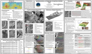
1. Abridged Abstract:
Stepped
fans—conical
forms
with
stair-‐step
topography—are
rela7vely
rare
on
both
Earth
and
Mars.
We
characterized
the
morphological
a?ributes
of
mar7an
stepped
fans
to
ascertain
variability
among
this
class
of
landform
and
assess
the
plausibility
of
forma7on
hypotheses.
Stepped
fans
and
their
associated
catchment
were
examined
in
CTX
and
HiRISE
image
data
to
document
their
size,
feeder
channel
system,
planimetric
form
and
step
spacing.
In
addi7on,
the
topographic
form
(step
heights
and
inter-‐step
slope)
were
documented
for
select
stepped
fans
where
eleva7on
data
could
be
derived
from
HiRISE
stereo
image
pairs.
We
will
con7nue
to
refine
the
a?ributes
of
fans
within
each
category
through
further
interroga7on
of
fan
topography,
and
evaluate
whether
these
differences
reflect
dis7nct
processes.
This
study
could
yield
cri7cal
informa7on
regarding
Mars’
complex
history
of
standing
water
on
its
surface.
MORPHOLOGICAL ATTRIBUTES OF MARTIAN STEPPED
FANS
Evan
LEWIS1
Rebecca
M.E.
WILLIAMS2
Andrew
DE
WET1
1
Earth
&
Environment,
Franklin
&
Marshall
College,
415
Harrisburg
Ave,
Lancaster,
PA
17604-‐3003
2
Planetary
Science
Ins7tute,
1700
East
Fort
Lowell,
Suite
106,
Tucson,
AZ
85719
Session
No.
307-‐-‐Booth#
333
Planetary
Geology
(Posters)
Wednesday,
4
November
2015:
9:00
AM-‐6:30
PM
2015
GSA
Annual
Mee7ng
in
Bal7more,
Maryland,
USA
(1-‐4
November
2015)
Paper
No.
307-‐19
Presenta7on
Time:
9:00
AM-‐6:30
PM
Fan 45: A Complex Stepped Fan Memnonia: A Simple Stepped Fan
Discussion
Conclusions
Sites Se.ng Type
Basin
Area
(km^2)
Fan
Area
(km^2)
Channel
Area
(km^2)
Strahler
Stream
Order
Surficial
Incision
Channel
Brink
Points
Avg.
Brink
Point
Spacing
(m)
Memnonia Crater Simple 3195 6.56 42.32 1st Remnant 13 427
Fan
15 Crater Complex 3778 18.03 16.64 2nd No 11 1868
Tyras Crater Simple 2029 77.41 182.75 2nd Remnant 10 1171
Fan
22 Crater Simple 892 23.38 17.53 1st No 6 523
Fan
27
Fre?ed
Canyon Complex 3337 45.94 33.77 2nd Remnant 9 4830
Fan
30
Ellipse
Crater Simple 553 10.38 430.57 3rd Remnant 6 900
Fan
34 Crater Simple 1164 14.05 8.87 1st No 5 467
Fan
37 Crater Simple 3291 66.61 29.76 2nd Remnant 10 2153
Fan
45 Crater Complex 852 55.27 27.52 1st Yes 15 406
Fan
46
Fre?ed
Canyon Simple 642 12.85 15.80 1st Yes 2 NA
Coprates
Fre?ed
Canyon Simple 620 38.31 113.59 1st Yes 21 623
Gale Crater Complex 18166 2.08 183.21 1st Yes 4 894
• Complex
fan
• Transect
bends
at
brink
point
8
and
begins
to
trend
more
southerly
sugges7ng
several
possible
phases
of
forma7on
• 15
Major
brink
points
• Mul7ple
channel
incisions
present
on
fan
surface
• Formed
in
a
crater
basin
• V-‐shaped
feeder
channel
• Fan
height
approximately
400
m
• Fan
length
approximately
6,000
m
• Major
brink
points
mapped
by
following
steep
changes
in
slope
• Eleva7on
profiles
along
brink
points
plot
flat
over
large
distances
• Brink
points
follow
contours
of
equal
eleva7on
• Unusual
depression
formed
between
lobes
12
and
13
at
the
top
of
Memnonia
is
interpreted
as
late
stage
aeolian
erosion
• Lobes
13
and
12
seem
separate
according
to
slope
shade
but
appear
the
same
according
to
eleva7on
• Simple
fan
• Transect
is
linear
with
concentric
lobes
• 13
Major
brink
points
• No
channel
incisions
present
on
fan
surface
• Formed
in
a
crater
basin
• V-‐shaped
feeder
channel
• Fan
height
is
approximately
175
m
• Fan
length
approximately
7,040
m
General Characteristics of Stepped Fans
• Simple
fans
were
triangular
in
map
view,
had
laterally
con7nuous,
concentric
lobes
and
had
roughly
equal
lobe
spacing
• Complex
fans
appear
to
have
superimposed
lobes
on
top
of
each
other,
were
irregularly
shaped
in
map
view
and
are
highly
variable
in
appearance
Mar;an
stepped-‐delta
forma;on
by
rapid
water
release:
Kraal
et
al.
(2008)
Laboratory
experiments
conducted
by
Kraal
et
al
(2008)
suggest
that
morphological
features
observed
with
stepped
fans
on
Mars
could
be
explained
by
the
following
processes:
I. Feeder
channel
breaching
the
crater
wall
II. Alluvial
fan
deposi7on
on
crater
floor
III. Accumulated
sediment
on
valley
floor
decreases
infiltra7on
rate
and
increases
accumula7on
of
water
IV. Rising
water
levels
paired
with
con7nuous
deposi7on
form
stepped
delta
lobes
V. Con7nuing
sedimenta7on
would
yield
prograding
lobes
over
exis7ng
ones
VI. Con7nua7on
of
flow
without
sedimenta7on
would
yield
erosive
channels
on
fan
surface
A
A’
A
A’
A
A’
A
A’
Hypothesis
for
FormaJon
of
Stepped
Fans
Expected
morphological
features
and
observaJons
EvaluaJon
and
interpretaJon
1.
Volcanic
flows
• Lava
Vents
or
cones
• Volcanic
flow
textures
• No
evidence
of
ac7ve
or
relict
volcanism
observed
2.
Mass
was7ng
• Internal
layering
• Lobate
step
shape
• Unobserved
lobes
and
internal
layering
of
sediment
is
atypical
of
mass
was7ng
events
3.
Alluvial
fan
sheet
floods
• Integrated
drainage
network
• Discon7nuous,
nonconcentric
steps
• Nonconcentric
and
discon7nuous
steps
are
atypical
of
terrestrial
alluvial
fans
4.
Erosion
of
fan
• Wave
cut
benches
should
display
associated
shorelines
on
highlands
• Lack
of
shoreline
evidence
on
crater
rim
suggests
alterna7ve
forma7on
methods
5.
Fan-‐delta:
Transgressive
case
• Integrated
drainage
network
• Dis7nc7ve
longitudinal
profile
• Some
fans
lack
incision
channels
on
surface
• Supported
by
Kraal
model
and
occurrence
of
incision
channels
on
fan
surface
suggests
subaerial
erosion
aler
stepped
fan
deposi7on
6.
Fan-‐delta:
Regressive
case
• Integrated
drainage
network
• Dis7nc7ve
longitudinal
profile
• Incision
channels
observed
on
some
fan
surfaces
• Not
all
fans
exhibit
incision
channels
• Similar
to
the
transgressive
case,
only
not
all
fans
exhibit
incision
channels
on
their
surfaces
as
would
be
expected
with
a
regressive
model.
Background
37_2N51WÜ
1.5 0 1.50.75 Kilometers
34_10S306EÜ
0 0.45 0.9 1.35 1.80.225
Kilometers
22_8S214EÜ
0 1 2 3 40.5
Kilometers
21_16S205E
0 1 2 3 40.5
Kilometers
Ü 15_9N16E
0 1 2 3 40.5
Kilometers
Ü
Methods
• Lobes
on
stepped
fan
surfaces
were
mapped
along
the
top
of
the
lobe
• Lobes
were
mapped
by
observing
changes
in
slope
from
a
slopeshade
DEM
• To
be
considered
major
lobes
must
be
con7nuous
and
concentric
• Most
major
lobes
also
displayed
changes
in
albedo
as
a
result
of
the
change
in
slope
and
were
also
observable
via
satellite
imagery
• Not
all
shils
in
albedo,
observed
with
satellite
imagery,
represented
a
lobe
feature
Hypothesized
FormaJon
Methods
I. Volcanic
flow
deposits
II. Mass
was7ng
events
III. Erosion
of
alluvial
fan
by
means
of
erosive
wave
ac7on
IV. Alluvial
fan
deposi7on
V. Transgressive
deposi7on
of
fan-‐delta
VI. Regressive
deposi7on
of
fan-‐delta
Here
we
focus
on
evalua7ng
fan-‐delta
scenarios,
consistent
with
prior
studies
laboratory
simula7ons,
and
terrestrial
analogs
(eg.
1-‐8
references
from
proposal).
Memnonia
Fan
45
LocaJon
of
Stepped
Fans
on
Mars
Examples of Martian Stepped Fans
Incised
Chanel
1.
Classifica7on
of
‘simple’
and
‘complex’
fans
based
on
morphological
a?ributes
in
image
data
may
not
reflect
forma7on
process.
Ini7al
assessment
of
eleva7on
data
for
two
fans
illustrated
that
the
‘simple’
fan
had
a
dis7nct
character
in
the
upper
and
lower
reaches,
whereas
the
‘complex’
fan
had
a
simple
form.
This
result
highlights
the
importance
of
high-‐resolu7on
eleva7on
data
as
landform
shape
is
not
always
discernible
in
image
data
alone.
4.
Fan
45
has
a
uniform
slope
of
~8
degrees
with
steps
every
~270
m
distance
and
~28
m
eleva7on
change.
The
change
in
fan
orienta7on
reflects
topographic
confinement,
rather
than
different
forma7on
processes.
Con7nuous
water
level
rise
may
result
in
equally
spaced
steps
(Muto
and
Steel,
2001a,
see
proposal).
2.
Longitudinal
profiles
for
the
two
Mar7an
stepped
fans
examined
only
slightly
differed
from
that
formed
in
the
laboratory
simula7on
(Kraal
et
al.,
2008),
and
suggest
that
stepped
fan
forma7on
may
involve
similar
processes
but
with
a
unique
development
scenarios
7ed
to
water
fluctua7ons
at
each
site.
-‐
We
see
some
evidence
for
an
earlier
alluvial
fan
phase
in
the
fan
form
at
site
45
-‐Although
Memnonia
fan
was
ini7ally
compared
to
the
laboratory
simula7on
by
Kraal
et
al.
(2008),
we
observe
the
steps
are
concentrated
on
the
mid
and
lower
fan,
not
the
upper
fan
as
in
the
simula7on.
Also,
the
lower
fan
has
two
pronounced
benches
that
may
reflect
stable
or
repeated
lake
levels
at
these
lower
eleva7ons.
Our
observa7ons
suggest
step
forma7on
is
associated
with
varia7ons
in
water
level.
Along-‐step
profiles
are
horizontal,
consistent
with
shoreline
intersec7ons
with
the
fan
surface.
Future
work
will
examine
eleva7on
data
for
other
Mar7an
stepped
fans
and
inves7gate
what
details
of
discharge
and
lake
level
fluctua7ons
are
consistent
with
the
observed
mar7an
fan
shape.
Up
fan
Memnonia: A Simple Stepped Fan
Memnonia: Transects
Fan 45: Transects
Up
fan
Up
fan
Up
fan
Fan
45
Memnonia
Simple
Fan
Simple
Fan
Simple
Fan
Simple
Fan
Complex
Fan
Kraal Laboratory Model
Simple
Fan
3.
Memnonia
has
no
obvious
rela7onship
between
step
spacing
and
fan
slope.
The
fan
profile
has
three
components:
a
shallow
0.5
degrees
upper
fan
with
no
steps,
a
steeper
4
degree
mid-‐fan
that
transi7ons
to
the
lower
fan
with
benches.
Where
steps
occur
(steps
4-‐11,
below
-‐2070
m),
they
have
~248
m
spacing,
but
the
ver7cal
drop
between
steps
varies
from
~
2
m
to
~
20
m.
Stable
lake
levels
may
have
formed
the
distal
benches.
The
complex
fan
45
exhibits
some
interes7ng
morphological
features:
• Surficial
incision
channels
easily
observed
along
the
delta
lobe
suggest
subaerial
fluvial
erosion
and
possibly
a
regressive
fan-‐delta
deposi7onal
sepng
Incision
Channels
References:
-‐Kraal,
Erin
R.,
et
al.
"mar7an
Stepped-‐Delta
Forma7on
By
Rapid
Water
Release."
Nature
21
Feb.
2008:
973-‐77
-‐De
Villiers,
Germari,
Maarten
G.
Kleinhans,
and
George
Postma.
"Experimental
delta
forma7on
in
crater
lakes
and
implica7ons
for
interpreta7on
of
Mar7an
deltas."
Journal
of
Geophysical
Research:
Planets
118.10
(2013):
651-‐70
-‐Weitz,
Catherine
M.,
et
al.
"Forma7on
of
a
terraced
fan
deposit
in
Coprates
Catena,
Mars."
Icarus
184
(2006):
436-‐51
The
topographic
profile
of
complex
fan
45
is
similar
in
many
ways
the
Kraal
laboratory
model
created
under
controlled
transgressive
water
level
condi7ons
• The
X-‐X’
profile
to
the
right
shares
morphological
characteris7cs
with
the
Kraal
laboratory
controlled
profile
below.
Both
have
in
common
the
general
shape
and
placement
of
the
Crater
Floor
(CF),
Delta
Lobe
(DL)
and
Stream
Canyon
(SC)
in
profile.
X’
X
CF
DL
SC
A
A’
A
A’
To
the
lel
are
two
panels
illustra7ng
the
thermophysical
proper7es
of
fan
45.
There
is
a
subtle
change
that
occurs
as
a
func7on
of
fan
posi7on.
The
upper
fan
where
steps
occur
is
characterized
by
a
rela7vely
uniform
~230
7u
(thermal
iner7a
unit),
whereas
the
lower
fan
exhibits
an
increase
to
~290
7u.
These
values
are
consistent
with
weakly
to
moderately
indurated
sedimentary
deposits,
but
the
higher
thermal
iner7a
values
in
the
distal
part
of
the
fan
suggests
a
coarsening
outward
trend
that
is
consistent
with
the
inferred
change
in
deposi7onal
environment
from
subaerial
deposi7on
in
the
lower
reaches
to
subaqueous
deposi7on
upfan
in
a
lacustrine
environment.