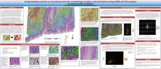
This study analyzed over 1600 streamlined glacial landforms in Connecticut using LiDAR data and GIS analyses. Key findings include:
1) Drumlin orientations are locally controlled by topography but generally follow regional trends likely set by glacial lobes.
2) Till deposits are found on the up-flow and down-flow sides of obstructions in high relief areas.
3) In high relief areas, drumlin asymmetry is controlled by local topography and drumlin size by the space between hilltops.