This notes provide the information about tectonic divisions and evolution of Himalayas. movement of Indian plate has also taken up in brief.
Tectonic Division of Himalaya
Evolution of Himalaya
Movement of Indian Plate.
Resource description_ Rasoul Sorkhabi, The himalayan Journal, 2010
The term "trap" has been used in geology since 1785–95 for rock formations. It is derived from the Swedish word for stairs (trapp , trappa) and refers to the step-like hills forming the landscape of the region.
The plateau: also called a high plain or tableland, is an area of highland, usually consisting of relatively flat terrain. A plateau is an elevated land. It is a flat-topped table standing above the surrounding area. A plateau may have one or more sides with steep slopes.
LIP – Large Igneous provinces. (Province = Area / Region)
DVP - The Deccan Volcanic Province is one of the Earth’s giant continental flood basalts and has a total exposed area of about half a million square kilometers in Maharashtra, Madhya Pradesh, Gujrat and some part of Andhra Pradesh. Deccan trap has maximum thickness 3400m in western ghat and its thickness goes decrease toward east side. At Amrakantat on east its thickness is just 160m. Geographical distribution is between latitudes 16° - 24° N and longitudes 70° - 77° E.
Petroleum exploration project on the Halfway Formation in the Dimsdale Oil Field, working alongside another student geologist by analyzing the depositional environments, hydrocarbon trapping methods, oil-water contact, well interpretation, basin model building, and volumetric measurements on hydrocarbons.
The Chilcotin Basalts: implications for mineral explorationGraham Andrews
This is a presentation I gave at the GSA Cordilleran Meeting in Kelowna, BC, in May 2009. It presents advanced results from geological studies of the Chilcotin Group basalts in south-central BC, and their impact on mineral exploration activities.
Students, digital devices and success - Andreas Schleicher - 27 May 2024..pptxEduSkills OECD
Andreas Schleicher presents at the OECD webinar ‘Digital devices in schools: detrimental distraction or secret to success?’ on 27 May 2024. The presentation was based on findings from PISA 2022 results and the webinar helped launch the PISA in Focus ‘Managing screen time: How to protect and equip students against distraction’ https://www.oecd-ilibrary.org/education/managing-screen-time_7c225af4-en and the OECD Education Policy Perspective ‘Students, digital devices and success’ can be found here - https://oe.cd/il/5yV
Synthetic Fiber Construction in lab .pptxPavel ( NSTU)
Synthetic fiber production is a fascinating and complex field that blends chemistry, engineering, and environmental science. By understanding these aspects, students can gain a comprehensive view of synthetic fiber production, its impact on society and the environment, and the potential for future innovations. Synthetic fibers play a crucial role in modern society, impacting various aspects of daily life, industry, and the environment. ynthetic fibers are integral to modern life, offering a range of benefits from cost-effectiveness and versatility to innovative applications and performance characteristics. While they pose environmental challenges, ongoing research and development aim to create more sustainable and eco-friendly alternatives. Understanding the importance of synthetic fibers helps in appreciating their role in the economy, industry, and daily life, while also emphasizing the need for sustainable practices and innovation.
How to Make a Field invisible in Odoo 17Celine George
It is possible to hide or invisible some fields in odoo. Commonly using “invisible” attribute in the field definition to invisible the fields. This slide will show how to make a field invisible in odoo 17.
Welcome to TechSoup New Member Orientation and Q&A (May 2024).pdfTechSoup
In this webinar you will learn how your organization can access TechSoup's wide variety of product discount and donation programs. From hardware to software, we'll give you a tour of the tools available to help your nonprofit with productivity, collaboration, financial management, donor tracking, security, and more.
Operation “Blue Star” is the only event in the history of Independent India where the state went into war with its own people. Even after about 40 years it is not clear if it was culmination of states anger over people of the region, a political game of power or start of dictatorial chapter in the democratic setup.
The people of Punjab felt alienated from main stream due to denial of their just demands during a long democratic struggle since independence. As it happen all over the word, it led to militant struggle with great loss of lives of military, police and civilian personnel. Killing of Indira Gandhi and massacre of innocent Sikhs in Delhi and other India cities was also associated with this movement.
The French Revolution, which began in 1789, was a period of radical social and political upheaval in France. It marked the decline of absolute monarchies, the rise of secular and democratic republics, and the eventual rise of Napoleon Bonaparte. This revolutionary period is crucial in understanding the transition from feudalism to modernity in Europe.
For more information, visit-www.vavaclasses.com
How to Create Map Views in the Odoo 17 ERPCeline George
The map views are useful for providing a geographical representation of data. They allow users to visualize and analyze the data in a more intuitive manner.
Unit 8 - Information and Communication Technology (Paper I).pdfThiyagu K
This slides describes the basic concepts of ICT, basics of Email, Emerging Technology and Digital Initiatives in Education. This presentations aligns with the UGC Paper I syllabus.
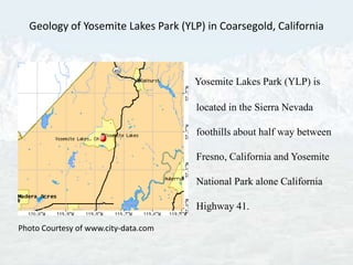
1. Geology of Yosemite Lakes Park (YLP) in Coarsegold, California Yosemite Lakes Park (YLP) is located in the Sierra Nevada foothills about half way between Fresno, California and Yosemite National Park alone California Highway 41. Photo Courtesy of www.city-data.com
2. The geological processes that have created the beautiful landscape of YLP are just a small part of much larger system. Mainly, the Sierra Nevada Mountain Range. Shuteye Peak in the Sierra Nevada
3. The Sierra Nevada stretches for 400 miles (646 kilometers) along the eastern side of California. It is the longest and highest continuous mountain range in the lower forty-eight states. It is a well-pronounced asymmetrical mountain range with a steep east escapement and a gradual westward sloping side that extends into the broad San Joaquin Valley. A large normal system fault along the eastern edge of the Sierra Nevada, called the Sierra Nevada Fault, began to uplift about 25 million years ago at the end of the Oligocene epoch. The uplift was due to a major change in the motion of the North American plate. The Farallon oceanic plate, that was being subducted under what would become the Sierra Nevada Mountain Range, was totally consumed into the subduction zone.
4. The Pacific plate that moved into its place was moving in a different direction (northwest). The new boundary between the North American plate and the Pacific plate became a strike-slip fault system known today as the San Andreas. The change in motion from a convergent to a lateral movement produced a different stress on the Sierra Nevada region. Since the Sierra Nevada initial begin, the uplift has accelerated. It is estimated that the Sierra Nevada uplifts at a rate of 4 centimeters for every 100 years. The continental crust east of the region began to expand and the Sierra Nevada region began to rise. Below is a picture of the uplift and tilt of the Sierran Block with the east escarpment formed along the fault and the gently sloping western side.
5. The Sierran Block is in the center of a highly active geological area. To the north is the very volcanically active Cascade Mountain range; to the south the Garlock Fault system running east to west; to the east is the Basin & Range province with many active fault systems such as Eastern California Shear Zone & Sierra Nevada Seismic Belt; and, of course, the world famous San Andreas Fault.
6. The San Andreas is a major fault of an intricate fault network that cuts through the California coastal region. The entire San Andreas Fault system is more than 800 miles long and extends to depths of at least 10 miles. The fault is a complex zone of crushed and broken rock from a few hundred feet to a mile wide. Many smaller faults branch from and join the San Andreas Fault zone .
7. The Sierran Block is a large batholith that forms the core of the Sierra Nevada Mountain Range. The batholith is composed of plutons that formed deep underground during a magma intrusion event many millions of years before the Sierra Block began to rise. The extremely hot more buoyant plutons called diapirs intruded through denser country rock and sediments, but never reaching the surface. Additionally during the magma intrusion, some magma reached the surface as lava flows, but most of it cooled and hardened below the surface and remained buried for millions of years. As the mountains rose, erosion wore down the material that had covered the batholith. The exposed portions are the familiar granite peaks of the Sierra Nevada mountain range, but most of the batholith remains below the surface.
8. The Sierra Batholith, containing plutonic rocks (igneous rock), ranging from granite to granodiorite to diorite. Granite Granodiorite This chart illustrates the generalized mineral composition of igneous rocks. Granite, compositionally equivalent to granite but of a fine grain size, are composed mainly of orthoclase feldspar, quartz, plagioclase feldspar, mica and amphibole. Diorite
9. In the Sierra Nevada Mountains a process known as sheeting is taking place. Sheeting occurs when large masses of igneous rock are exposed by erosion resulting in concentric slabs breaking loose of the main structure. This breaking loose or sheeting is caused by the reduction of pressure when the overlying rock is eroded away, a process known as unloading. As the rock unloads, the upper outer layer expands more than the lower rock that causes separation from the Batholith. As this process continues weathering eventually causes slabs to separate creating exfoliation domes.
10. The best-known example of an exfoliation dome is Half Dome in Yosemite National Park. Half Dome Yosemite National Park California
12. Revis Mountain Revis Mountain is a mountain summit in Madera County in California. Latitude: N 37.194392 Longitude: W -119.745985 Facing East. This is a view of Granite Mountain from Revis Mountain Summit. Revis Mountain Summit is 2,162 feet (658.98 meters).
13. Revis Mountain Southern View of Revis Mountain in Yosemite Lakes Park, California. Distant Northern View of Revis Mountain taken from Chukchansi Gold Resort & Casino, Coarsegold, California
14. Exfoliation is evident all over the YLP area. Below pictures are locations of exfoliation on Revis Mountain.
15. Igneous Material Intrusion Tabular Intrusion I. Intrusive rocks are classified according to their shape and orientation. A. The two general types are tabular and massive. 1. Tabular describes a feature having two dimensions that are much longer than the third. 2. Massive is an igneous pluton not tabular in shape. B. Intrusive igneous material that cuts across existing sedimentary beds are discordant and those that form parallel to the existing sedimentary beds are concordant.
16. Granite Granite comes from the Latin word "granum" (or grain) because of it granular texture. Sometimes members of this group are also called granitiods or quartz-feldspar-plutonic rocks. These are the most widely distributed plutonic rocks. Light colored mineral that is 20-60 % quartz, 40-80% feldspar and 0-20% dark minerals such as biotite, augite, hornblende, muscovite, apatite, zircon and/or magnetite. Feldspar, quartz and biotite (mica) are popularly considered to be the essential constituents of granite. Quartz is the second most abundant mineral in the Earth's continental crust is made up of a continuous framework of SiO4 silicon–oxygen tetrahedral, with each oxygen being shared between two tetrahedral, giving an overall formula SiO2. Feldspars , the most abundant mineral in the Earth’s continental crust (KAlSi3O8 - NaAlSi3O8 - CaAl2Si2O8) are a group of rock-forming tectosilicate minerals which make up as much as 60% of the Earth's crust. A mineral composed largely of linked chain of silica, aluminum and oxygen elements. Feldspar means "field crystal." Biotite is a common phyllosilicate mineral within the mica group, with the approximate chemical formula (Mg,Fe)3AlSi3O10(F,OH)2.
17. Granite of Yosemite Lakes Park On the left are three views of a same granite formation. Granite formation is located on Revis Mountain Weathered Not Weathered
18. Hydrology of YLP Hydrology is the study of water and its interactions with the landscape. One fourth of the Earth's continents is composed of mountainous terrain and mountain rivers.
19. Water. Water, everywhere. Water run off near top of Revis Mt. Yosemite Lakes Park received over 8 inches of rain during the month of March, 2011
20. Spectacular Water Fall in YLP Hydrology seeks to understand the processes that control the flow of water.
24. The Hydrology of YLP is fascinating to examine because the park lies at the center of one of the most extreme Mediterranean type climates on the Earth. Such climates are characterized by cool, wet winters and long, dry summers. During the winters, large Pacific storms bring high amounts of moisture into California. As this warm moist air encounters the Sierra Nevada Mountains, it is forced up and over a crest. As the air moves up and over the mountains, it cools causing water to condense and precipitate as rain and/or snow. This is the reason why 50 percent of California’s water comes solely from the Sierra Nevada. It is referred to as the Orographic Effect.
25. GOLD! The Mother Lode! Quartz Gold California highway 49 The Golden Chain Coarsegold, California and YLP lay at the southern end of California gold country. Coarsegold Creek is an excellent source of placer gold. Young mountain ranges are ideal locations for gold mining. The Sierra Nevada is a very young mountain range being less than 30 million years old.
26. SUMMARY Sierra Nevada Uplift is due to the Farallon Plate subducting under the North American Plate. It is estimated that the Sierra Nevada uplifts at a rate of 4 centimeters for every 100 years. The Sierran Block is a large batholith that forms the core of the Sierra Nevada . The Sierra Batholith, containing plutonic rocks (igneous rock), ranging from granite to granodiorite to diorite. Sierra Nevada Mountain Range is dominated by exfoliating granite domes, i.e. Half Dome. YLP’s largest exfoliating dome is Revis Mountain with an elevation of 2,162 feet (658.98 meters). Revis Mountain is an exfoliating dome. Granite in YLP is composed of quartz, feldspar and biotite (mica). Granite on Revis Mountain displays much igneous intrusions. The Hydrology of YLP is fascinating to examine because the park lies at the center of one of the most extreme Mediterranean type climates on the Earth. Coarsegold Creek is an excellent location to prospect for placer gold. Following pictures displays the natural beauty of Yosemite lakes Park, California.