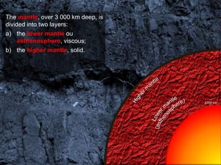
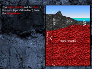
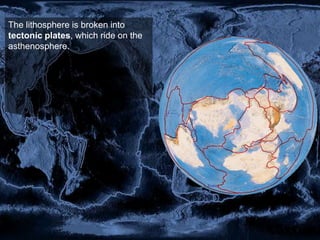
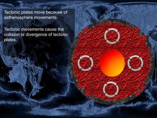
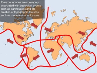
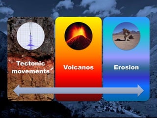
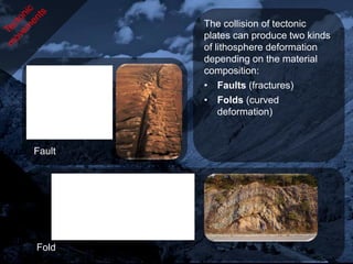
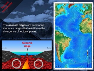
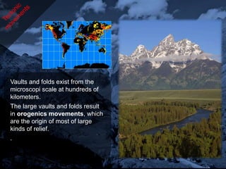
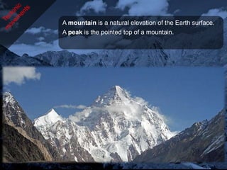
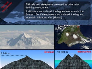
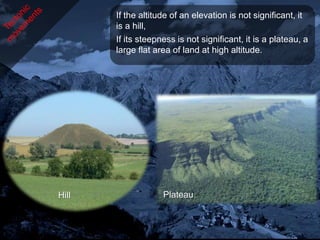
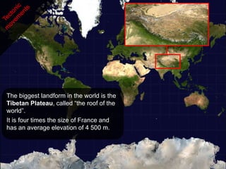
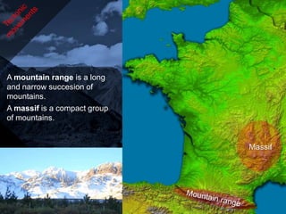
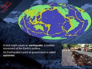
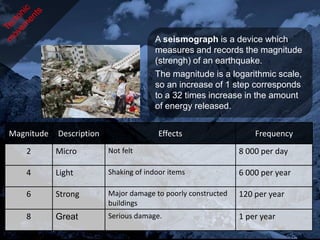
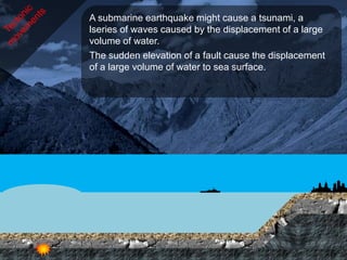
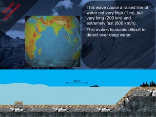
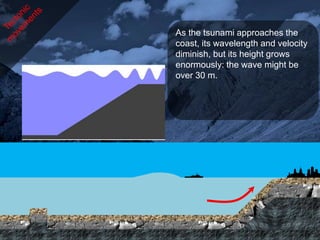
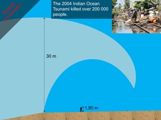
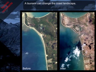
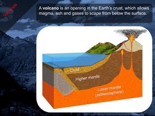
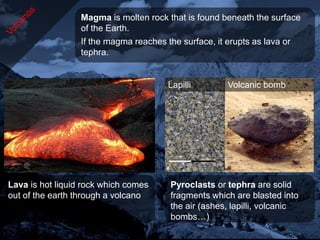
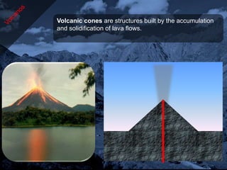
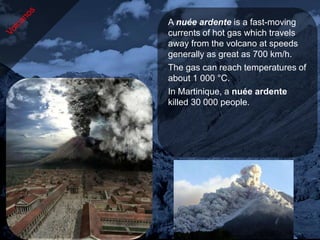
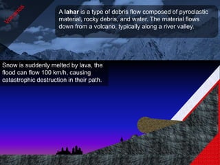
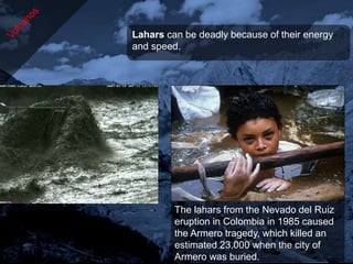
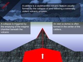
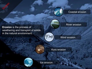
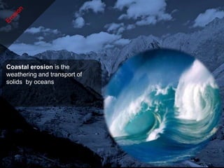
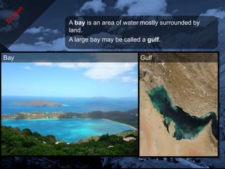
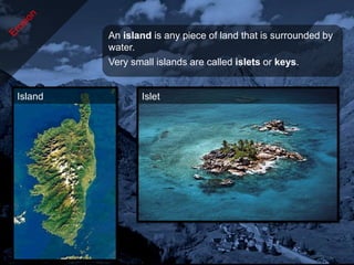
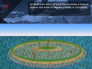
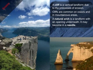
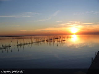
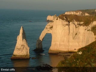
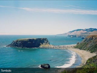
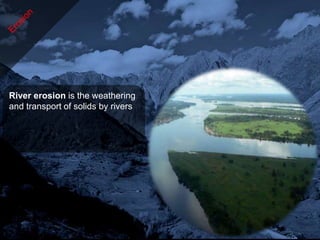
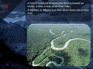
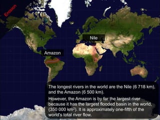
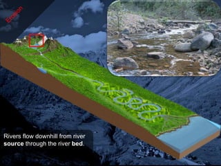
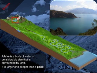
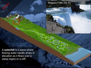
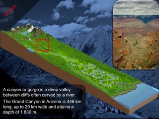
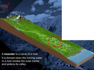
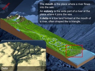
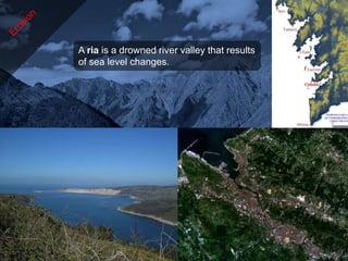
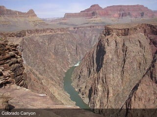
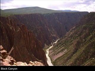
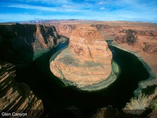
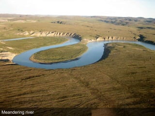
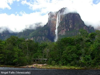
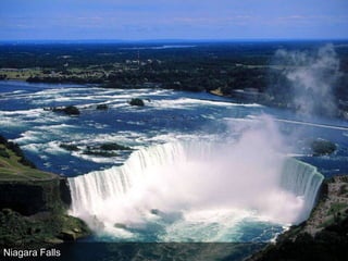
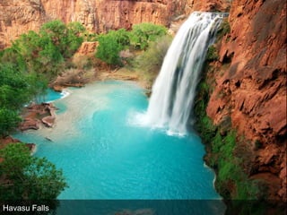
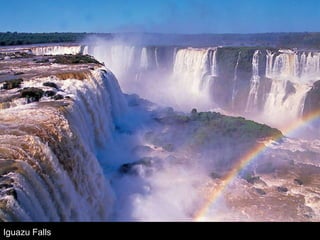
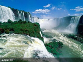
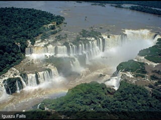
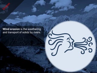
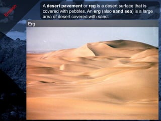
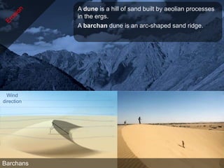
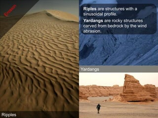
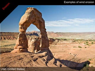
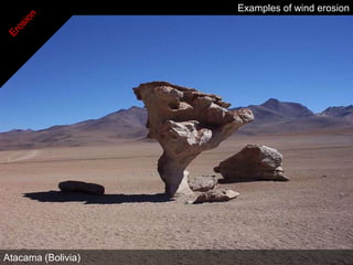
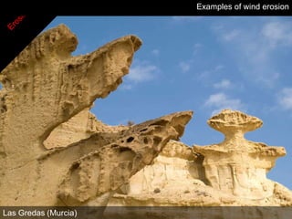
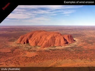
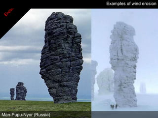
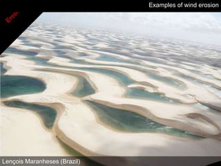
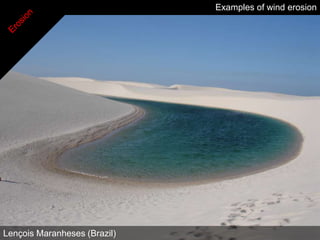
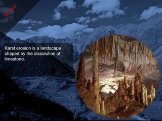
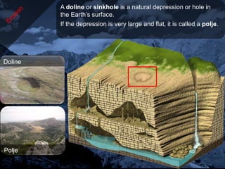
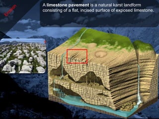
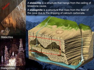
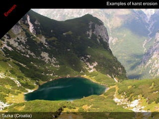
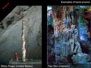
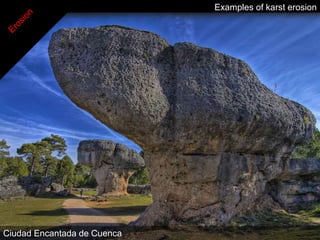
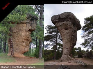
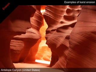
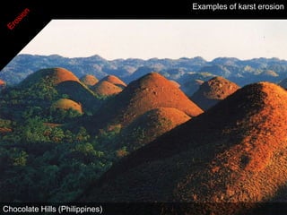
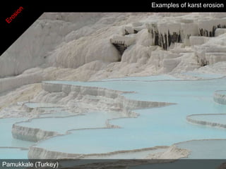
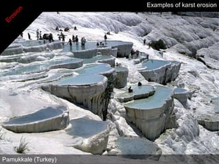
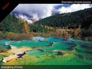
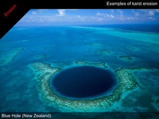
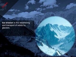
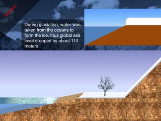
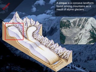
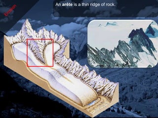
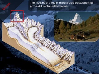
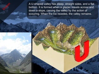
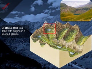
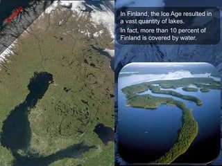
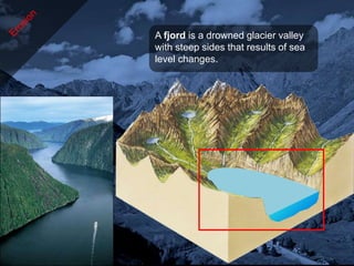
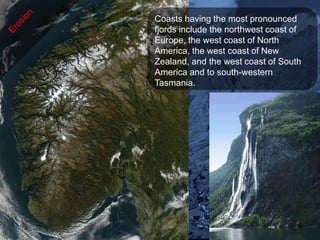
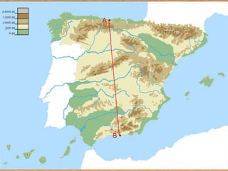
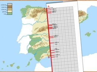
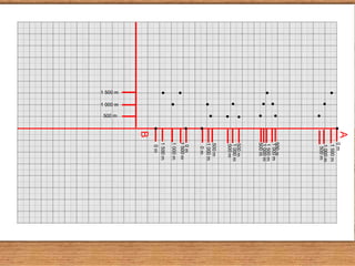
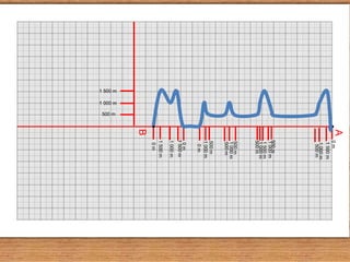
The document discusses various types of landforms created by tectonic activity and erosion processes on Earth. It describes how tectonic plates interact and cause geological events like earthquakes and volcanoes that shape the surface of the planet. Specifically, it details how plate collisions can form mountains and volcanoes, while plate divergences produce ocean ridges. It also explains different erosional forces like rivers, wind, glaciers, and karst that carve and transport earthen materials, forming diverse topographic features over long periods of time.
The document discusses various aspects of volcanoes and volcanic eruptions. It defines key terms like volcano, lava, magma, pyroclastics, crater, and describes different types of volcanic eruptions and the landforms they produce. Specifically, it distinguishes between shield volcanoes, cinder cones, and composite cones; and explains how factors like magma composition, temperature, and gas content determine eruption styles.
Volcanoes form when magma reaches the surface of the Earth. They can be found along plate boundaries where magma is able to reach the surface. There are over 1300 potentially active volcanoes worldwide. Volcanoes have different features like craters, vents, and magma chambers. They also go through life cycle stages of being active, dormant, or extinct. Eruptions can produce different types of lava and ash deposits that build different types of volcanic cones over time. While volcanoes provide fertile soils and minerals, their eruptions can negatively impact the environment through poisonous gases, lava flows, ash falls, pyroclastic flows, and lahars that damage infrastructure and agriculture.
A volcano is a mountain that opens downward to a pool of molten rock below the surface of the earth. When pressure builds up, eruptions occur. Gases and rock shoot up through the opening and spill over or fill the air with lava fragments. Eruptions can cause lateral blasts, lava flows, hot ash flows, mudslides, avalanches, falling ash and floods. Volcano eruptions have been known to knock down entire forests. An erupting volcano can trigger tsunamis, flash floods, earthquakes, mudflows and rockfalls.
The document summarizes different types of volcanic eruptions and igneous activity. It discusses factors that influence the violence of eruptions like magma composition, temperature, and dissolved gases. It also describes different types of volcanoes like shield volcanoes, cinder cones, and composite cones. Plate tectonics provide mechanisms for magma generation at convergent and divergent plate boundaries as well as intraplate hotspots.
1) The document proposes the hydroplate theory as an alternative to plate tectonics to explain geological phenomena.
2) It suggests that a layer of water trapped under the crust ruptured, causing massive flooding that separated the continents and formed new geological features rapidly.
3) As the continents drifted apart, mountain ranges formed from buckling plates and impacts, and the remaining water drained in massive floods, eventually receding to form the oceans and end the proposed flood period.
Geophysics is the study of the physical properties of the Earth. The Earth is composed of three main zones - the crust, mantle, and core. The crust makes up the outer solid layer and exists in two types, continental and oceanic. Below the crust is the mantle, which takes up 70% of the Earth's mass and is solid but plastic. The innermost part is the core, which has a liquid outer core and solid inner core. The Earth's crust and upper mantle are broken into tectonic plates that move slowly over time. Volcanoes and earthquakes occur near plate boundaries as a result of this movement. Earthquakes release energy in seismic waves that can be measured on scales such as the Richter
God, the Creator -- The Works of His HandsKaren Lall
The document provides information on several notable natural wonders and astronomical objects:
- Iguazu Falls in Brazil are twice as wide as Niagara Falls with 275 cascades over nearly two miles.
- The Grand Canyon is 277 miles long, 4-18 miles wide and a mile deep, located along the Colorado River in Arizona.
- The Canadian Rockies are renowned for stunning scenery, clean air, and unspoiled wilderness.
- Victoria Falls on the Zambezi River bordering Zambia and Zimbabwe is the largest sheet of falling water in the world.
Ophiolites provide evidence for the composition and structure of oceanic crust and the upper mantle. They represent sections of oceanic crust and upper mantle that have been obducted or thrust onto continental margins. Studying ophiolites like the Samail ophiolite in Oman has helped scientists understand the layered sequence of rocks that make up oceanic crust, including extrusive basalts, dikes, and intrusive gabbros.
The document summarizes key topics related to Earth's structure and relief formation. It describes the internal layers of the Earth including the crust, mantle, and core. It discusses plate tectonics and how the movement of tectonic plates leads to collisions and separations that form mountains and ocean ridges. It also outlines three main types of relief - continental, coastal, and ocean - and provides examples of associated landforms like mountains, valleys, beaches, and ocean trenches.
Prentice Hall Earth Science ch10 volcanoesTim Corner
The document discusses factors that affect the violence of volcanic eruptions including the composition, temperature, and dissolved gases of magma. More viscous magma produces more violent eruptions as gases cannot escape as easily. There are three main types of volcanoes - shield volcanoes formed from fluid basaltic lava, cinder cones formed from pyroclastic material from a single vent, and composite cones which are the most violent type formed from both lava and pyroclastic material. The document also briefly mentions plutons, which are intrusive igneous rocks that form from cooling magma underground.
This document discusses natural hazards caused by tectonic and climate-related events. It provides details on the internal structure of the Earth, including the crust and mantle. It then focuses on plate tectonics, explaining the three main types of plate boundaries and associated landforms. Specific examples are given for each plate boundary type. The document also addresses causes of earthquakes and their impacts, as well as types and characteristics of volcanoes.
The document describes the structure of the Earth, explaining that the inner core is made of iron and nickel, the mantle contains magma, and the crust is broken into tectonic plates that move due to convection currents in the mantle. It also labels the parts of a volcano and defines the three stages of volcanic activity as active, dormant, and extinct. Finally, the document discusses the impacts of volcanic eruptions and ways volcanoes provide benefits to surrounding areas.
Volcanism occurs when magma from the Earth's core escapes and cools, forming new rock. There are three main types of volcanism: underwater volcanism at divergent plate boundaries, volcanism at destructive plate boundaries where an oceanic plate subducts under a continental one, and volcanism at hot spots caused by fixed columns of magma rising from the mantle. A volcano has several parts including a vent, cone, pipe, crater, lava, and magma chamber below. Volcanoes can be classified as acid lava, basic lava, or composite depending on their lava composition and eruption style. Pakistan has many active mud volcanoes located in Balochistan that passively emit gases. Living near volcanoes
Human civilization has existed for a very short time on Earth. If we take the existence of Earth as equivalent to one year in time. Then human civilisation only appears on the last second of the last hour of the last day in the Earth’s year. Human has been fighting each other since the beginning of history. In the last century, we had two World Wars, when millions were killed. But I am the luck generation that miraculously never experienced wars, although the drums of wars are never too far away. We have arsenals of weapons that could destroy the world many times over. In my life time, I have also seen many of our children, marrying people of different races too. Our greatest enemy is ourselves. If we can survive this, there is the whole universe to explore. Finally, just remind ourselves that the longest Ice Age on Earth lasted for well over 1 billion years long and our civilisation is only 10,000 years old. 16 Jan 2022.
Volcanoes form when molten rock erupts from the earth's crust. There are several types of volcanoes including shield volcanoes, cinder cone volcanoes, composite volcanoes, caldera volcanoes, and fissure volcanoes. Volcanoes are most common along tectonic plate boundaries in the Pacific Ring of Fire and where convection currents in the mantle upwell. Eruptions occur via explosions that release underground gases and magma due to a decrease in pressure from earthquakes or other crustal shifts. Major eruptions can cause widespread destruction through lava flows, poisonous gases, ash falls, and landslides.
CSEC Geography- Internal Forces - Plate Tectonics and EarthquakesOral Johnson
This document looks at the Earth's internal forces. The main layers of the earth are described. The history surrounding plate tectonics is discussed. The different types of plate boundaries is also explained.
The theory of continental drift proposes that approximately 200 million years ago, there was a single supercontinent called Pangea that has since broken apart. The earth's tectonic plates, huge pieces of shifting rock, have moved and separated due to the planet's rotation. When plates collide, one can rise to form mountains while the other subducts under the ocean to form trenches.
A volcano has a crater on its surface that leads down to a magma chamber below ground containing molten rock called magma. When the magma rises up through the pipe conduit and erupts out of the volcano, it emerges as lava on the surface or in large lava lakes within the crater.
The eruption of Mount St. Helens in 1980 caused its height to decrease significantly. An earthquake triggered a landslide that caused a bulge on the mountain to eject magma, water, and gases. Volcanic activity occurs mainly at plate boundaries and is caused by melting of solid rock into magma under conditions of high temperature and pressure.
This is the entire CSEC geography syllabus (some things might be missing). The information was collected from various websites and textbooks. The topics are:
- Internal forces
-External forces
-Rivers
-Limestone
-Coasts
-Coral reefs and Mangroves
-Weather and Climate
- Ecosystems (vegetation and soils)
-Natural hazards
- Urbanization
-Economic activity
-Environmental degradation
The document discusses plate tectonics and the structure of the Earth. It describes how seismic waves can reveal layers inside the Earth like the crust, mantle, and core. It explains continental drift and how the theory of plate tectonics developed. Plates move at boundaries where they can spread apart, collide, or slide past each other, causing earthquakes and building landforms.
The document discusses the Earth's internal structure and processes. It describes two models that explain the Earth's internal layers: the geochemical model which divides the Earth into crust, mantle, and core, and the dynamic model which divides it into lithosphere, asthenosphere, mesosphere, and endosphere. The primary cause of Earth's internal activity is convection currents transferring heat from the core outward. This movement of heat drives the movement of tectonic plates at convergent, divergent, and transform boundaries, resulting in geologic processes such as volcanoes and earthquakes.
This document provides an overview of the internal structure of the Earth and types of relief on its surface. It discusses how the lithosphere is made up of tectonic plates that move via processes like collision and separation. It also describes three main types of relief - continental, coastal, and ocean - and the landforms that comprise each, like mountains, valleys, peninsulas, and ocean ridges. Finally, it lists the six widely recognized continents from largest to smallest.
Volcanoes form when molten rock from beneath the earth's crust, called magma, reaches the surface. They occur at places where tectonic plates are moving apart or colliding. Magma originates from heat generated by radioactive elements and pressure changes caused by plate movement. It ascends due to gases and vapors, erupting at the surface as either lava or explosive pyroclastic materials. Volcanoes are classified based on their eruption periodicity and can have varying eruption styles from fissure eruptions to more explosive types.
The document describes the layers of the geosphere - the crust, mantle, and core. It then discusses changes caused by internal forces like volcanoes and earthquakes, and external forces like wind and water erosion. Volcanoes form where magma surfaces, erupting through vents. Earthquakes are caused by crustal movements. Weathering and erosion shape the landscape through water and wind. Rocks form the crust and are classified as sedimentary, igneous, or metamorphic based on their formation. The document concludes by defining different types of landscapes like mountains, plains, and coastal regions.
The Earth formed around 4.5 billion years ago. It is the third planet from the sun and the only known planet capable of sustaining life. The Earth has a molten iron core, a solid silicate mantle, and a crust consisting of tectonic plates that migrate across the surface over millions of years. The Earth's atmosphere, hydrosphere, and biosphere support around 8.7 million known species of life. Humans depend on the biosphere and minerals of the Earth, though pollution poses threats to both the environment and human health.
Physical Geography Lecture 11 - The Lithosphere 111416angelaorr
The document discusses geologic time and how rocks are dated. It describes how radiometric dating is used to determine the absolute age of rocks by measuring radioactive decay. The oldest rocks on Earth are around 3.96 billion years old. It also discusses the theory of uniformitarianism and how the same geologic processes that shape the Earth today have operated throughout its history.
Este documento presenta lineamientos para elaborar guías de intervención destinadas a disminuir la brecha en salud mental en atención primaria. Propone temas como envejecimiento saludable, intervención laboral e infantil, y promoción de la salud mental. Además, describe los aspectos a considerar en la guía como presentación, objetivos, justificación, temas, estrategias y evaluación. Finalmente, da instrucciones para la conformación de grupos y la presentación del trabajo final.
Un hombre le pregunta a una bibliotecaria por un libro. Ella asume que está buscando un libro sobre hombres y sexo, y le indica que la sección de ciencia ficción está en el piso de abajo, insinuando sutilmente que el tema que busca no es real.
The document discusses the impact of globalization on education. It defines globalization as the growing integration of economies worldwide through increased trade, investment, and technology transfer. Globalization influences education through economic, political, and cultural forces. It creates demands for lifelong learning, flexible skills, and more access to education. Reforms are needed in education to modernize curricula for a globalized world and make students productive members of society. The internationalization of education and privatization of schools are effects of globalization on education systems.
Tale of two canals narmada canal and yamuna canalNamo League
The Narmada Canal in Gujarat provides drinking water to 29 million people in rural areas through a network of canals and pipelines. It has been dubbed the 'Lifeline of Gujarat'. In contrast, the Yamuna Canal in Delhi cannot be used for drinking water as sewage flows directly into the canal from the city. About 70% of the river's pollution is attributed to a 22 km stretch in Delhi. As a result, the Yamuna Canal in Delhi is derogatorily referred to as the 'Sewage Canal'.
Los diagnósticos de enfermería se caracterizan por tratar sobre estados o problemas de salud reales o potenciales que requieren de una valoración para obtener y analizar datos, llegando a una conclusión sobre cómo la persona afronta sus procesos vitales según la Teoría de las Necesidades humanas. Los diagnósticos se basan en datos empíricos y abordan aspectos biológicos, psicológicos y socioculturales para proporcionar un cuidado integral, describiendo problemas propios del rol de enfermería.
A volcano is a rupture in the crust of a planetary-mass object, such as Earth, that allows hot lava, volcanic ash, and gases to escape from a magma chamber below the surface.
The document summarizes key information about the structure and composition of the Earth. It describes the three main layers - the core, mantle, and crust. The core has a solid inner core and liquid outer core made of iron and nickel. The mantle is the largest layer and mainly composed of silicate minerals. It is divided into the rigid lithosphere and soft asthenosphere. The crust is the thin outer layer composed of different rock types and containing all life.
The document summarizes plate tectonics and its relationship to various geological phenomena. There are three main types of plate boundaries - divergent where plates move apart, convergent where they collide in subduction or collision zones, and transform where they slide past each other. Plate movement is responsible for volcanoes, earthquakes, and mountain building. Earthquakes occur when stress builds up at faults until the plates suddenly slip, releasing energy. Tsunamis are large sea waves generated by earthquakes or landslides that flood coastal areas.
The document summarizes key aspects of the geosphere:
1) The Earth consists of layers with different compositions - a crust, mantle, and core made of increasingly dense materials;
2) The lithosphere is made up of tectonic plates that move and interact, causing earthquakes at boundaries and building mountains when they collide;
3) Volcanoes form at plate boundaries and erupt, posing local risks but also affecting global climate through ash and gases released.
This document provides information about earthquakes and volcanoes. It defines an earthquake as the shaking and trembling that results from the sudden movement of parts of the earth's crust. Earthquakes are caused by the movement of tectonic plates. When the stress between plates becomes too great, the crust breaks and energy is released in waves. Volcanoes form at places where magma reaches the earth's surface. There are three main types of volcanoes - cinder cones formed from explosive eruptions, shield volcanoes composed of fluid lava flows, and composite volcanoes with layers of ejected material and lava.
The document discusses evidence that mega-tsunamis from volcanic eruptions and flank collapses destroyed ancient civilizations over 50,000 years ago. Specifically, it notes that as the last glacial period ended around 12,000 years ago, stress imbalances triggered eruptions of stratovolcanoes located on shelves surrounding Asia. Landslides of these volcanoes would have generated mega-tsunamis over 100 meters high, capable of wiping out coastal settlements and islands across the northern hemisphere. The waters northeast of Taiwan in particular contain evidence of undersea volcanoes and faults that could have historically generated tsunamis impacting ancient civilizations.
This document discusses volcanoes and earthquakes. It begins by explaining that tectonic movements like earthquakes and volcanoes can abruptly change the Earth's surface features. It then defines earthquakes as vibrations produced in rocks, and describes the different types of earthquake waves. Causes of earthquakes include movement along faults in the Earth's crust. Volcanoes originate from magma pockets that form below the Earth's surface due to decreased pressure. The document outlines different types of volcanoes based on eruption style and activity level. It also describes the products of volcanic eruptions, including solid, liquid, and gaseous materials. Various landforms associated with volcanoes are also explained, such as volcanic cones, ash
Mass extinctions have occurred throughout the Phanerozoic era over the past 542 million years where a significant proportion (30-95%) of species went extinct. There have been 5 major mass extinctions identified, including the end-Ordovician, Late Devonian, end-Permian, end-Triassic, and end-Cretaceous extinctions. Potential causes of mass extinctions include supercontinent formation, extra-terrestrial impacts, flood basalt eruptions, methane hydrate releases, and rapid glaciation events. Compelling evidence indicates that the end-Cretaceous extinction 65 million years ago, which wiped out the dinosaurs, was caused by the impact of a large 10km
The document summarizes key aspects of Earth's internal structure, surface features, tectonic plates, earthquakes, volcanoes, and landforms. The Earth has a solid crust on top of a thick mantle and liquid outer and solid inner cores. Over 70% of the surface is ocean, covering underwater volcanoes, mountains and trenches. The remaining 30% includes various landforms like forests and deserts. Tectonic plates float on the mantle and interact, causing earthquakes and forming volcanoes and mountains. Earthquakes generate seismic waves and tsunamis. Volcanoes form at plate boundaries and erupt molten magma from the crust. Important landforms include mountains, valleys, plains and coastal features.
Volcanoes form when magma rises up from below the Earth's crust and erupts. There are three main types of volcanic eruptions that differ based on the speed and viscosity of the magma: magmatic, phreatomagmatic, and phreatic. Monitoring volcanoes for changes in shape, temperature, and seismic activity can help predict eruptions and allow for evacuation planning to reduce risk to humans. The largest volcanic eruption in history was the Lake Toba eruption in Indonesia around 75,000 years ago.
The document provides information about the Earth's layers, including the mantle and tectonic plates. It describes how igneous rocks are formed from magma underground or lava above ground. It also explains how sedimentary rocks are formed over millions of years from the erosion and deposition of earth materials. Metamorphic rocks are formed from intense heat and pressure changing other rock types over long periods of time.
Volcanoes form when hot molten rock (magma) rises from below the Earth's surface and erupts. They consist of a vent, conduit and surrounding cone built from erupted material. Most volcanoes occur at plate boundaries or hot spots. Magma rises due to lower density and pressure changes, erupting either explosively with gas-rich magma or effusively with low-viscosity magma. Eruptions produce hazards like lava flows, pyroclastic flows and falls. Notable examples include Vesuvius destroying Pompeii and Krakatoa's powerful 1883 eruption. Supervolcanoes are capable of much larger eruptions than normal volcanoes.
The document discusses the causes and types of earthquakes. It begins by noting that records of earthquakes date back thousands of years in some areas. It then explains that earthquakes are caused by the sudden movement of tectonic plates deep below the earth's surface. The major types of plate boundaries are divergent boundaries where new crust forms, convergent boundaries where plates collide and crust is destroyed, and transform boundaries where plates slide past each other. Specific examples like the Mariana Trench and San Andreas Fault are also described.
Geography Project on Volcanoes, made by a 14 year old student as his school submission work, has almost all the required information about the Volcanoes and includes case studies & maps of major volcanic regions of the world, active volcanoes of the world, Volcanic eruptions in the modern times.
Copyright (c) 2021-2022 Ishan Ketan Bhavsar
TO BE USED FOR EDUCATIONAL PURPOSES ONLY
Volcanoes are openings in the Earth's crust where magma and gases erupt. During an eruption, volcanoes expel lava, ash, dust, gas and vapor. There are three types of volcanoes: active volcanoes that are currently erupting or may erupt soon, dormant volcanoes that have not erupted for a long time, and extinct volcanoes that have not erupted for over 10,000 years. Volcanic eruptions produce rocks and lava that make soil fertile for farming and also provide geothermal energy for human use, but they can also endanger lives through hazards like lava and ash flows, bombs and clouds during an eruption.
Volcanoes form when magma rises from below the Earth's surface and erupts. Most volcanoes occur near tectonic plate boundaries, especially around the Pacific Ring of Fire. During an eruption, magma and gases blast out of a vent, piling up over time to form a volcanic mountain. Common volcanic materials include lava, rock fragments, and gases. Famous volcanoes include Mount St. Helens in the US, Mauna Loa in Hawaii, and Nevado del Ruiz in Colombia.
Plate tectonics theory proposes that the Earth's crust is divided into plates that move over time. Evidence for this includes matching geological formations between continents that have since drifted apart. The Earth has a solid inner core, liquid outer core, and mantle below the crust. Plates meet at boundaries that are either constructive, where plates move apart, or destructive, where plates converge. Earthquakes are often caused by stresses building up at plate boundaries. Volcanic activity commonly occurs near plate boundaries as well.
Notes on living with tectonic hazards n levelsivisdude82
1. Tectonic hazards such as earthquakes and volcanic eruptions are caused by movements of the Earth's crust along tectonic plates. The plates move due to convection currents in the upper mantle and subduction of denser oceanic plates under lighter continental plates.
2. Where plates diverge, mid-ocean ridges and rift valleys are formed. As plates converge, fold mountains like the Himalayas or Andes are formed. Transform boundaries like the San Andreas Fault cause earthquakes as the plates slide past each other.
3. Volcanoes form at plate boundaries due to upwelling of magma. Shield volcanoes have low, broad slopes while stratovolcanoes
Volcanic eruptions occur when magma reaches the Earth's surface through cracks in the crust. They can be devastating in the short term but also beneficial in the long run by enriching soils. Two main types are shield volcanoes, which erupt gently and form low slopes, and composite volcanoes with alternating lava and ash layers that can produce deadly pyroclastic flows. The eruption of Yellowstone supervolcano thousands of years ago was catastrophic globally. Montserrat was devastated in the 1990s when the Soufriere Hills volcano erupted, destroying the capital and forcing mass evacuations, though it has since calmed and rebuilding is underway.
People still choose to live near volcanoes despite the dangers for several reasons:
1. The soil from volcanic eruptions is very fertile, making the land suitable for agriculture.
2. Volcanic areas are rich in valuable minerals, providing jobs from mining these resources.
3. Tourism to view volcanoes can generate income for local communities through businesses catering to visitors.
4. With limited land available for housing and farms, volcanoes may be the only option despite the risks. The economic benefits outweigh the dangers for sustaining livelihoods.
Forms of Energy discusses different types of energy including primary energy sources like petroleum, coal, and natural gas. It provides information on how these energy sources are extracted, transformed, distributed and consumed. It notes that while these traditional fossil fuels currently provide much of the world's energy needs, they are non-renewable and contribute to greenhouse gas emissions and other pollution. The document advocates increasing reliance on alternative and renewable energy sources like wind and solar power.
This document defines and describes different biomes around the world. It provides details on the climate, vegetation, and common animal species found in polar biomes like tundra and boreal forest, temperate biomes like temperate forest and steppe, and tropical biomes like rainforest, savanna, and desert. Specific biomes discussed in more depth include rainforest, savanna, desert, Mediterranean forest, temperate forest, steppe, boreal forest, tundra, and mangrove. Each biome is characterized by distinct environmental conditions that have led to the evolution of specially adapted plant and animal life.
The document provides information about the universe and our solar system. It discusses the formation of the universe in the Big Bang around 14 billion years ago. It then describes our solar system, including details about the sun, planets, and other celestial objects. It explains Earth's rotation, revolution around the sun, and axial tilt, which causes the seasons and variations in daylight hours at different latitudes.
This presentation was provided by Racquel Jemison, Ph.D., Christina MacLaughlin, Ph.D., and Paulomi Majumder. Ph.D., all of the American Chemical Society, for the second session of NISO's 2024 Training Series "DEIA in the Scholarly Landscape." Session Two: 'Expanding Pathways to Publishing Careers,' was held June 13, 2024.
This document provides an overview of wound healing, its functions, stages, mechanisms, factors affecting it, and complications.
A wound is a break in the integrity of the skin or tissues, which may be associated with disruption of the structure and function.
Healing is the body’s response to injury in an attempt to restore normal structure and functions.
Healing can occur in two ways: Regeneration and Repair
There are 4 phases of wound healing: hemostasis, inflammation, proliferation, and remodeling. This document also describes the mechanism of wound healing. Factors that affect healing include infection, uncontrolled diabetes, poor nutrition, age, anemia, the presence of foreign bodies, etc.
Complications of wound healing like infection, hyperpigmentation of scar, contractures, and keloid formation.
Level 3 NCEA - NZ: A Nation In the Making 1872 - 1900 SML.pptHenry Hollis
The History of NZ 1870-1900.
Making of a Nation.
From the NZ Wars to Liberals,
Richard Seddon, George Grey,
Social Laboratory, New Zealand,
Confiscations, Kotahitanga, Kingitanga, Parliament, Suffrage, Repudiation, Economic Change, Agriculture, Gold Mining, Timber, Flax, Sheep, Dairying,
THE SACRIFICE HOW PRO-PALESTINE PROTESTS STUDENTS ARE SACRIFICING TO CHANGE T...indexPub
The recent surge in pro-Palestine student activism has prompted significant responses from universities, ranging from negotiations and divestment commitments to increased transparency about investments in companies supporting the war on Gaza. This activism has led to the cessation of student encampments but also highlighted the substantial sacrifices made by students, including academic disruptions and personal risks. The primary drivers of these protests are poor university administration, lack of transparency, and inadequate communication between officials and students. This study examines the profound emotional, psychological, and professional impacts on students engaged in pro-Palestine protests, focusing on Generation Z's (Gen-Z) activism dynamics. This paper explores the significant sacrifices made by these students and even the professors supporting the pro-Palestine movement, with a focus on recent global movements. Through an in-depth analysis of printed and electronic media, the study examines the impacts of these sacrifices on the academic and personal lives of those involved. The paper highlights examples from various universities, demonstrating student activism's long-term and short-term effects, including disciplinary actions, social backlash, and career implications. The researchers also explore the broader implications of student sacrifices. The findings reveal that these sacrifices are driven by a profound commitment to justice and human rights, and are influenced by the increasing availability of information, peer interactions, and personal convictions. The study also discusses the broader implications of this activism, comparing it to historical precedents and assessing its potential to influence policy and public opinion. The emotional and psychological toll on student activists is significant, but their sense of purpose and community support mitigates some of these challenges. However, the researchers call for acknowledging the broader Impact of these sacrifices on the future global movement of FreePalestine.
Gender and Mental Health - Counselling and Family Therapy Applications and In...PsychoTech Services
A proprietary approach developed by bringing together the best of learning theories from Psychology, design principles from the world of visualization, and pedagogical methods from over a decade of training experience, that enables you to: Learn better, faster!
3. The Earth is divided into layers :
1. The core
2. The mantle
3. The crust
3
2
1
4. The core, over 6 000 km deep, is
made of iron and nickel. Earth’s
core temperature is estimated at
around 5 000 ºC.
The outer core, is liquid, but the
inner core remains solid because
of the high pressure.
6 000 km
5. The mantle, over 3 000 km deep, is
divided into two layers:
a) the lower mantle ou
asthenosphere, viscous;
b) the higher mantle, solid.
3 000 km
6. The higher mantle and the crust, a
thin solid layer (5 km deep), form
the lithosphere.
30 km
5 km
Crust
Lithosphere
Higher mantle
8. The lithosphere is broken into
tectonic plates, which ride on the
asthenosphere.
9. Tectonic plates move because of
asthenosphere movements.
Tectonic movements cause the
collision or divergence of tectonic
plates.
10. Plate boundaries are commonly
associated with geological events
such as earthquakes and the
creation of topographic features
such as mountains or volcanoes
11. Continents move at a speed of 10
cm per year because of plates
tectonics.
Continental drift is the movement
of the Earth's continents.
12. Cambrian 500 m. a.
Arthropodes (e.g. trilobites) prosper in the
oceans.
Trilobite
13. Ordovician 470 m. a.
The water temperature close to the surface is
40 ºC. One day is equivalent to 21 hours.
14. Silurien 430 m. a.
Land plants evolve from algae.
15. Dévonien 370 m. a.
First amphibians evolved from fish.
16. Carboniferous 300 m. a.
Earth is covered by forests, which produced
large quantities of coal in Europe.
First reptiles developed in response to an
drier climate.
17. Trias 220 m. a.
Pangaea was the supercontinent that existed
250 million years ago, before the component
continents were separated into their current
configuration.
18. Jurassic 150 m. a.
A warmer and wetter climate allows the
developement of large rainforests. Ice caps
don’t exist.
It was a golden age for dinosaurs.
19. Cretaceous 65 m. a.
Asteroid
A massive asteroid impact of 10 km caused
the a mass extinction of animal and plant
species.
20. Éocène 50 m. a.
Mammals expand after the extinction of the
dinosaurs. Australia separated from
Anctartica. The Himalaya is a result of the
continental collision between the indo-
Asutralian plate and the Eurasian Plate.
21. +50 m. a.
+250 m. a.
In several million years,
Africa will collide with
Europe.
Finally, every continent
will form a new
pangaea.
24. The collision of tectonic
plates can produce two kinds
of lithosphere deformation
depending on the material
composition:
• Faults (fractures)
• Folds (curved
deformation)
Fault
Fold
25. The oceanic ridges are submarine
mountain ranges that result from the
divergence of tectonic plates.
Oceanic
ridge
America Europe
26. Vaults and folds exist from the
microscopi scale at hundreds of
kilometers.
The large vaults and folds result
in orogenics movements, which
are the origin of most of large
kinds of relief.
.
27. A mountain is a natural elevation of the Earth surface.
A peak is the pointed top of a mountain.
28. Altitude and steepness are used as criteria for
defining a mountain.
If altitude is considered, the highest mountain is the
Everest. But if steepnees is considered, the highest
mountain is Mauna Kea (Hawai).
Everest 10 200 m Mauna Kea
8 844 m
29. If the altitude of an elevation is not significant, it
is a hill,
If its steepness is not significant, it is a plateau, a
large flat area of land at high altitude.
Hill Plateau
30. The biggest landform in the world is the
Tibetan Plateau, called “the roof of the
world”.
It is four times the size of France and
has an average elevation of 4 500 m.
31. A mountain range is a long
and narrow succesion of
mountains.
A massif is a compact group
of mountains.
Massif
32. A fault might cause an earthquake, a sudden
movement of the Earth’s surface.
An Earthquake’s point at ground level is called
epicenter.
33. A seismograph is a device which
measures and records the magnitude
(strengh) of an earthquake.
The magnitude is a logarithmic scale,
so an increase of 1 step corresponds
to a 32 times increase in the amount
of energy released.
Magnitude Description Effects Frequency
2 Micro Not felt 8 000 per day
4 Light Shaking of indoor items 6 000 per year
6 Strong Major damage to poorly constructed 120 per year
buildings
8 Great Serious damage. 1 per year
34. A submarine earthquake might cause a tsunami, a
lseries of waves caused by the displacement of a large
volume of water.
The sudden elevation of a fault cause the displacement
of a large volume of water to sea surface.
35. This wave cause a raised line of
water not very high (1 m), but
very long (200 km) and
extremely fast (800 km/h).
This makes tsunamis dificult to
detect over deep water.
200 km
36. As the tsunami approaches the
coast, its wavelength and velocity
diminish, but its height grows
enormously: the wave might be
over 30 m.
37. The 2004 Indian Ocean
Tsunami killed over 200 000
people.
30 m
1,80 m
38. A tsunami can change the coast landscape.
Before After
39. A volcano is an opening in the Earth’s crust, which allows
magma, ash and gases to scape from below the surface.
40. Magma is molten rock that is found beneath the surface
of the Earth.
If the magma reaches the surface, it erupts as lava or
tephra.
Lapilli Volcanic bomb
Lava is hot liquid rock which comes Pyroclasts or tephra are solid
out of the earth through a volcano fragments which are blasted into
the air (ashes, lapilli, volcanic
bombs…)
41. Volcanic cones are structures built by the accumulation
and solidification of lava flows.
42. A lava dome is a circular mound-shaped structure from
the slow eruption of very viscous lava from a volcano.
43. Volcanic fissures are fissures through which lava
erupts, usually without any explosive activity.
Volcanic fissures produce often lava fountains.
52. A fumarole is an opening in Earth’s crust which emits
steam and gases.
53. A geyser is a spring characterized by intermittent
discharge of water ejected turbulently and accompanied
by steam.
54. A nuée ardente is a fast-moving
currents of hot gas which travels
away from the volcano at speeds
generally as great as 700 km/h.
The gas can reach temperatures of
about 1 000 °C.
In Martinique, a nuée ardente
killed 30 000 people.
55. A lahar is a type of debris flow composed of pyroclastic
material, rocky debris, and water. The material flows
down from a volcano, typically along a river valley.
Snow is suddenly melted by lava, the
flood can flow 100 km/h, causing
catastrophic destruction in their path.
56. Lahars can be deadly because of their energy
and speed.
The lahars from the Nevado del Ruiz
eruption in Colombia in 1985 caused
the Armero tragedy, which killed an
estimated 23,000 when the city of
Armero was buried.
57. A caldera is a cauldron-like volcanic feature usually
formed by the collapse of land following a extremely
violent volcanic eruption.
A collapse is triggered by An islet (a dome) is often
the emptying of the magma formed in the center of the
chamber beneath the caldera..
volcano
59. The eruption of a caldera in Toba,
70 000 years ago, was the Earth’s
largest eruption.
This event resulted in a global
cooling of atound 15 ºC and 10
years volcanic winter.
61. Volcanos often form landscapes of remarkable beauty.
Champagne Pool (United Kingdom)
Giants Causeway (New Zealand)
Morning Glory Pool (United States)
65. Coastal erosion
River erosion
Erosion is the process of
weathering and transport of solids
in the natural environment.
Wind erosion
Kars erosion
Ice erosion
71. A beach is a landform along the shoreline of an
ocean, sea or lake
The color of sand depends on the composition: the
white sands contain coral and shell fragments; the
black sands have a volcanic origin.
Beachrock
Pebbles
Black sands
White sands
72. A sandbar is a linear landform extending into a body of
water, typically composed of sand or small pebbles.
73. Lagoon
A spit is a type of sandbar that
connects to land and extends into
the sea.
A lagoon is a body of sea water
separated from the sea by a bar.
A tombolo is a landform in which
an island is attached to the
mainland by a sandbar.
Spit Tombolo
74. A cliff is a vertical landform due
to the processes of erosion.
Cliffs are common on coasts and
in mountainous areas,
A natural arch is a landform with
an opening underneath. It may
become in a needle.
78. River erosion is the weathering
and transport of solids by rivers
79. A river is a natural watercourse flowing toward an
ocean, a lake, a sea, or another river.
A tributary or affluent is a river which flows into a main
river.
80. Nile
Amazon
The longest rivers in the world are the Nile (6 718 km),
and the Amazon (6 500 km).
However, the Amazon is by far the largest river
because it has the largest flooded basin in the world,
(350 000 km2). It is approximately one-fifth of the
world's total river flow.
82. A lake is a body of water of
considerable size that is
surrounded by land.
It is larger and deeper than a pond.
83. Niagara Falls (52 m)
A waterfall is a place where
flowing water rapidly drops in
elevation as it flows over a
steep region or a cliff.
84. A canyon or gorge is a deep valley
between cliffs often carved by a river.
The Grand Canyon in Arizona is 446 km
long, up to 29 km wide and attains a
depth of 1 830 m.
85. A meander is a curve of a river.
It is formed when the moving water
in a river erodes the outer banks
and widens its valley.
86. The mouth is the place where a river flows
into the sea.
An estuary is the wide part of a river at the
place where it joins the sea.
A delta is a low land formed at the mouth of
a river, often shaped like a triangle.
Delta
Estuaire
87. A ria is a drowned river valley that results
of sea level changes.
98. Wind erosion is the weathering
and transport of solids by rivers.
99. Wind erosion is very important in deserts because
of the lack of vegetation.
100. A desert pavement or reg is a desert surface that is
covered with pebbles. An erg (also sand sea) is a large
area of desert covered with sand.
Erg
Reg
101. A dune is a hill of sand built by aeolian processes
in the ergs.
A barchan dune is an arc-shaped sand ridge.
Wind
direction
Barchans
102. Riples are structures with a
sinusoidal profile.
Yardangs are rocky structures
carved from bedrock by the wind
abrasion.
Yardangs
Ripples
110. Karst erosion is a landscape
shaped by the dissolution of
limestone.
111. A doline or sinkhole is a natural depression or hole in
the Earth’s surface.
If the depression is very large and flat, it is called a polje.
Doline
Polje
112. A limestone pavement is a natural karst landform
consisting of a flat, incised surface of exposed limestone.
113. A stalactite is a structure that hangs from the ceiling of
limestone caves.
A stalagmite is a structure that rises from the floor of
the cave due to the dripping of calcium carbonate.
Stalactites
Stalagmites
124. Ice erosion is the weathering
and transport of solids by
glaciers.
125. A glacier is a large persistent body of ice.
Nowadays glaciers cover a small area of the Earth. However,
20,000 years ago, glacier covered large regions.
126. During glaciation, water was
taken from the oceans to
form the ice, thus global sea
level dropped by about 110
meters
127. Nowadays there are two types of glaciers:
1) the indlandsis or ice sheet, masses of glacier
ice that are greater than 50 000 km2 (Antarctica
and Greenland);
2) the alpine glaciers, formed on the crests of
mountains.
Indlandsis Alpine glacier
128. The indlandsis must be
distinguished from the sea ice,
formed from seawater that
freezes.
Sea ice cyclically freezes and
melts due to the seasons.
129. An iceberg is a large piece of
ice from freshwater that has
broken off from a glacier and is
floating in open water.
130. Alpine glaciers form on the crests and
slopes of mountains.
An alpine glacier that fills a valley is
sometimes called a valley glacier.
131. A cirque is a concave landform
found among mountains as a
result of alpine glaciers. .
132. A moraine is an accumulation
of glacial debris.
134. The meeting of three or more arêtes creates pointed
pyramidal peaks, called horns.
135. A U-shaped valley has steep, straight sides, and a flat
bottom. It is formed when a glacier travels across and
down a slope, carving the valley by the action of
scouring. When the ice recedes, the valley remains.
136. A glacial lake is a
lake with origins in a
melted glacier.
137. In Finland, the Ice Age resulted in
a vast quantity of lakes.
In fact, more than 10 percent of
Finland is covered by water.
138. A fjord is a drowned glacier valley
with steep sides that results of sea
level changes.
139. Coasts having the most pronounced
fjords include the northwest coast of
Europe, the west coast of North
America, the west coast of New
Zealand, and the west coast of South
America and to south-western
Tasmania.
141. A topographic map is a type of map
characterized by large-scale detail and
quantitative representation of relief,
142. Profil topographique
A contour line (also isohypse)
is a curve that joins points of
equal elevation (height).
Contour lines are represented
using numbers (100 m, 200 m,
etc.) or colors (green for
depressions, white for
mountains, etc.).
A topographic profile is a
vertical view of a topographic
map.
Carte cartographique
146. A 0m
1 500 m
1 000 m
500 m
500 m
1 000 m
1 500 m
1 000 m
500 m
500 m
1 000 m
500 m
500 m
1 000 m
0m
0m
1 500 m
1 000 m
1 500 m
0m
B
1 500 m
1 000 m
500 m
147. A 0m
1 500 m
1 000 m
500 m
500 m
1 000 m
1 500 m
1 000 m
500 m
500 m
1 000 m
500 m
500 m
1 000 m
0m
0m
1 500 m
1 000 m
1 500 m
0m
B
1 500 m
1 000 m
500 m