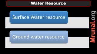
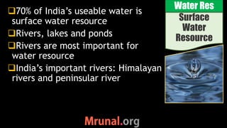
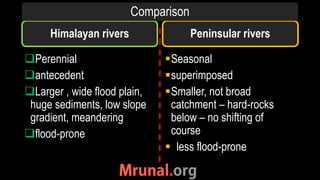
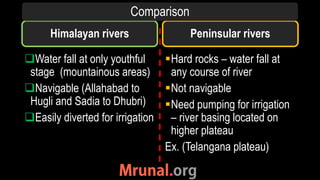
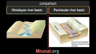
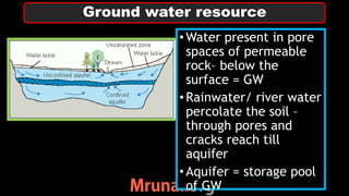
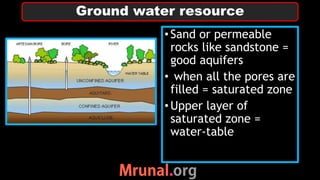
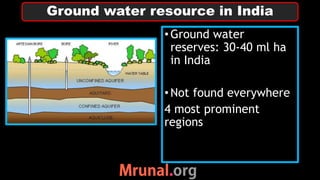
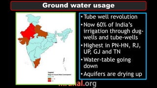
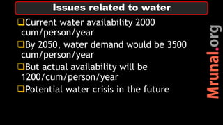
3. Surface
Water
Resource
Water Res
70% of India’s useable water is
surface water resource
Rivers, lakes and ponds
Rivers are most important for
water resource
India’s important rivers: Himalayan
rivers and peninsular river
4. Himalayan rivers
Perennial
antecedent
Larger , wide flood plain,
huge sediments, low slope
gradient, meandering
flood-prone
Seasonal
superimposed
Smaller, not broad
catchment – hard-rocks
below – no shifting of
course
less flood-prone
Peninsular rivers
Comparison
5. Himalayan rivers
Water fall at only youthful
stage (mountainous areas)
Navigable (Allahabad to
Hugli and Sadia to Dhubri)
Easily diverted for irrigation
Hard rocks – water fall at
any course of river
Not navigable
Need pumping for irrigation
– river basing located on
higher plateau
Ex. (Telangana plateau)
Peninsular rivers
Comparison
9. Ground water resource
•Water present in pore
spaces of permeable
rock– below the
surface = GW
•Rainwater/ river water
percolate the soil –
through pores and
cracks reach till
aquifer
•Aquifer = storage pool
of GW
10. •Sand or permeable
rocks like sandstone =
good aquifers
• when all the pores are
filled = saturated zone
•Upper layer of
saturated zone =
water-table
Ground water resource
11. •Ground water
reserves: 30-40 ml ha
in India
•Not found everywhere
4 most prominent
regions
Ground water resource in India
12. 1) Alluvial sedimentary
- Northern plains
- Peninsular river basins
-Deltas of rivers
-High water table
Ground water resource: Location
13. 2) Bhabhar (foothills of
Himalayas)
-Not important
-Coarse topography – no
soil
-Not important for
agriculture
Ground water resource : Location
14. 3) East and west coastal
plains
-Eastern coastal plain
broader and receive
large amount of rivers
-Issue of over-use
-Vulnerable to salinity
Ground water resource : Location
15. 4) Peninsular gneissic
and granitic rocks-
Impermeable rocks –
water stored in cracks
-once water is
extracted difficult to
recharge – easily
exhausted
Telangana, Dharwad,
Bastar, Rayalseema
Ground water resource : Location
16. Ground water
Reserve
Total ground water
reserve
Ganga ~17 ml ha
Godavari ~5 ml ha
Brahmaputra ~2.8 ml ha
Krishna ~2.6 ml ha
Indus ~2.5 ml ha
Ground water reserve in India
17. Ground water
Reserve
Level of GW
development
Indus (+PN-HN) ~80%
Cauveri ~45%
Kutchh-Saurashtra ~40%
Ganga basin ~31%
Penner basin ~30%
Development of use of GW
18. •50% already used
•rural household = >90%
•urban household =
~60%
•Un-planned urban
expansion – unreliable
municipal water supply
– urban sprawl
•GW cheap source,
need no infra
Ground water usage
19. •Tube well revolution
•Now 60% of India’s
irrigation through dug-
wells and tube-wells
•Highest in PN-HN, RJ,
UP, GJ and TN
•Water-table going
down
•Aquifers are drying up
Ground water usage
20. •Rate of usage > rate of
replishment
1) cities: alarming rate
of fall of GW table
2) Destruction of
aquifers
3) Over-dependent on
GW- salinity
Present availability of GW
21. 1) Fluoride- northern
plains, Telangana,
Golkonda
2) Arsenic – leather
industries- UP, Bihar,
WB (Malda,
murshidabad,
Burdwan, Asansol)
3) Nitrate – fertilizers-
across country
Ground water pollution
23. Current water availability 2000
cum/person/year
By 2050, water demand would be 3500
cum/person/year
But actual availability will be
1200/cum/person/year
Potential water crisis in the future
Issues related to water
24. Climatic regions of India
Vegetation pattern in India
Water resource:
1) Surface water resource
2) Ground water resource