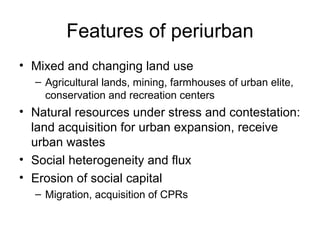
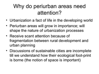
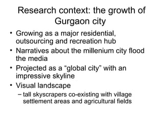
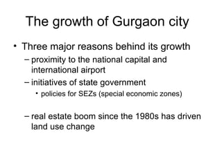
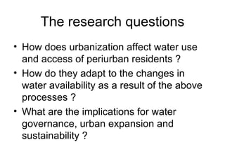
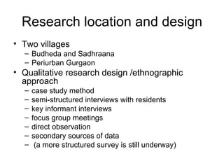
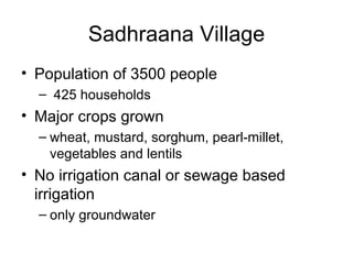
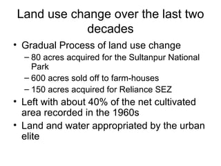
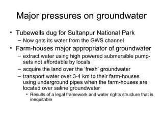
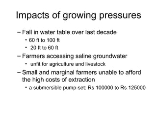
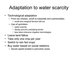
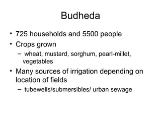
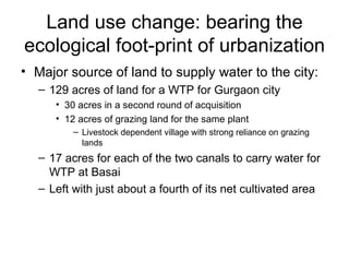
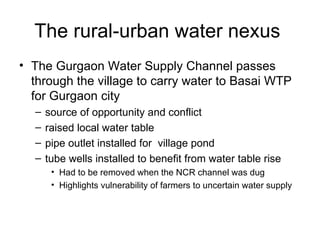
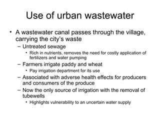
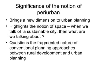
Understanding periurban water
            flows
   Implications for governance and urban
                   planning
               Vishal Narain, MDI, Gurgaon
   National Seminar organized by CSH, Human Settlement
               Management Institute, Delhi
                      July 15-16,2011
Overview of presentation
• Conceptualizing periurban
  – What do we mean by periurban
• Research design and context: the growth
  of Gurgaon city
• The case studies of Budheda and
  Sadhraana
• Implications for governance and
  sustainability of cities
Conceptualizing periurban
• No consensus definition
• As a place
  – Villages around cities
  – Most commonly used connotation of the term
• As a process
  – Process of transition from rural to urban
• As a concept
  – An analytic construct to study rural-urban
    relationships and flows of goods and services
Features of periurban
• Mixed and changing land use
  – Agricultural lands, mining, farmhouses of urban elite,
    conservation and recreation centers
• Natural resources under stress and contestation:
  land acquisition for urban expansion, receive
  urban wastes
• Social heterogeneity and flux
• Erosion of social capital
  – Migration, acquisition of CPRs
Why do periurban areas need
            attention?
• Urbanization a fact of life in the developing world
• Periurban areas will grow in importance; will
  shape the nature of urbanization processes
• Receive scant attention because of
  fragmentation between rural development and
  urban planning
• Discussions of sustainable cities are incomplete
  till we understand how their ecological foot-print
  is borne (the notion of space is important)
Research context: the growth of
          Gurgaon city
• Growing as a major residential,
  outsourcing and recreation hub
• Narratives about the millenium city flood
  the media
• Projected as a “global city” with an
  impressive skyline
• Visual landscape
  – tall skyscrapers co-existing with village
    settlement areas and agricultural fields
The growth of Gurgaon city
• Three major reasons behind its growth
  – proximity to the national capital and
    international airport
  – initiatives of state government
     • policies for SEZs (special economic zones)


  – real estate boom since the 1980s has driven
    land use change
The research questions
• How does urbanization affect water use
  and access of periurban residents ?
• How do they adapt to the changes in
  water availability as a result of the above
  processes ?
• What are the implications for water
  governance, urban expansion and
  sustainability ?
Research location and design
• Two villages
  – Budheda and Sadhraana
  – Periurban Gurgaon
• Qualitative research design /ethnographic
  approach
  –   case study method
  –   semi-structured interviews with residents
  –   key informant interviews
  –   focus group meetings
  –   direct observation
  –   secondary sources of data
  –    (a more structured survey is still underway)
Sadhraana Village
• Population of 3500 people
  – 425 households
• Major crops grown
  – wheat, mustard, sorghum, pearl-millet,
    vegetables and lentils
• No irrigation canal or sewage based
  irrigation
  – only groundwater
Land use change over the last two
            decades
• Gradual Process of land use change
  – 80 acres acquired for the Sultanpur National
    Park
  – 600 acres sold off to farm-houses
  – 150 acres acquired for Reliance SEZ
• Left with about 40% of the net cultivated
  area recorded in the 1960s
• Land and water appropriated by the urban
  elite
Major pressures on groundwater
• Tubewells dug for Sultanpur National Park
  – Now gets its water from the GWS channel
• Farm-houses major appropriator of groundwater
  – extract water using high powered submersible pump-
    sets not affordable by locals
  – acquire the land over the ‘fresh’ groundwater
  – transport water over 3-4 km to their farm-houses
    using underground pipes when the farm-houses are
    located over saline groundwater
     • Results of a legal framework and water rights structure that is
       inequitable
Impacts of growing pressures
– Fall in water table over last decade
   • 60 ft to 100 ft
   • 20 ft to 60 ft
– Farmers accessing saline groundwater
   • unfit for agriculture and livestock
– Small and marginal farmers unable to afford
  the high costs of extraction
   • a submersible pump-set: Rs 100000 to Rs 125000
Adaptation to water scarcity
• Technological adaptation
    – From lao chedas, rainth to tubewells and submersibles
        • small and marginal farmers left out
    – Use of sprinklers
        • water scarcity
        • Sandy soil and undulating terrain
        • less labor-intensive irrigation technologies
•   Leave land fallow
•   Take only one crop per year
•   Switch to rain fed crops
•   Buy water based on social relations
    – Social capital eroded in periurban areas
Budheda
• 725 households and 5500 people
• Crops grown
  – wheat, mustard, sorghum, pearl-millet,
   vegetables
• Many sources of irrigation depending on
  location of fields
  – tubewells/submersibles/ urban sewage
Land use change: bearing the
ecological foot-print of urbanization
• Major source of land to supply water to the city:
  – 129 acres of land for a WTP for Gurgaon city
     • 30 acres in a second round of acquisition
     • 12 acres of grazing land for the same plant
         – Livestock dependent village with strong reliance on grazing
           lands
  – 17 acres for each of the two canals to carry water for
    WTP at Basai
  – Left with just about a fourth of its net cultivated area
The rural-urban water nexus
• The Gurgaon Water Supply Channel passes
  through the village to carry water to Basai WTP
  for Gurgaon city
  –   source of opportunity and conflict
  –   raised local water table
  –   pipe outlet installed for village pond
  –   tube wells installed to benefit from water table rise
       • Had to be removed when the NCR channel was dug
       • Highlights vulnerability of farmers to uncertain water supply
Use of urban wastewater
• A wastewater canal passes through the village,
  carrying the city’s waste
  – Untreated sewage
     • Rich in nutrients, removes the need for costly application of
       fertilizers and water pumping
  – Farmers irrigate paddy and wheat
     • Pay irrigation department for its use
  – Associated with adverse health effects for producers
    and consumers of the produce
  – Now the only source of irrigation with the removal of
    tubewells
     • Highlights vulnerability to an uncertain water supply
What these studies tell us…
• Urbanization changes periurban water use
  and access
• Flows of water between villages and cities
  are in both directions
• Urbanization creates water insecurity (and
  not just scarcity)
• These flows need better appreciation in
  urban infrastructure provision and supply
  augmentation
Significance of the notion of
             periurban
• Brings a new dimension to urban planning
• Highlights the notion of space – when we
  talk of a sustainable city, then what are
  we talking about ?
• Questions the fragmented nature of
  conventional planning approaches
  between rural development and urban
  planning
Implications for governance
• As urbanization advances, periurban areas (and issues)
  will rise in significance
• Current processes of urbanization bear well neither for
  equity nor for sustainability
   – Cities growing beyond the carrying capacity compromise
     periurban residents’ access both to land and water
• Base urban expansion plans on studies of carrying
  capacity of cities
• Recognise the flows of water between rural and urban
  areas
   – Move away from seeing “rural water supply” and “urban water
     supply” as distinct conceptual entities

Understanding peri-urban water flows_Vishal Narain

  • 1.
    Understanding periurban water flows Implications for governance and urban planning Vishal Narain, MDI, Gurgaon National Seminar organized by CSH, Human Settlement Management Institute, Delhi July 15-16,2011
  • 2.
    Overview of presentation •Conceptualizing periurban – What do we mean by periurban • Research design and context: the growth of Gurgaon city • The case studies of Budheda and Sadhraana • Implications for governance and sustainability of cities
  • 3.
    Conceptualizing periurban • Noconsensus definition • As a place – Villages around cities – Most commonly used connotation of the term • As a process – Process of transition from rural to urban • As a concept – An analytic construct to study rural-urban relationships and flows of goods and services
  • 4.
    Features of periurban •Mixed and changing land use – Agricultural lands, mining, farmhouses of urban elite, conservation and recreation centers • Natural resources under stress and contestation: land acquisition for urban expansion, receive urban wastes • Social heterogeneity and flux • Erosion of social capital – Migration, acquisition of CPRs
  • 5.
    Why do periurbanareas need attention? • Urbanization a fact of life in the developing world • Periurban areas will grow in importance; will shape the nature of urbanization processes • Receive scant attention because of fragmentation between rural development and urban planning • Discussions of sustainable cities are incomplete till we understand how their ecological foot-print is borne (the notion of space is important)
  • 6.
    Research context: thegrowth of Gurgaon city • Growing as a major residential, outsourcing and recreation hub • Narratives about the millenium city flood the media • Projected as a “global city” with an impressive skyline • Visual landscape – tall skyscrapers co-existing with village settlement areas and agricultural fields
  • 7.
    The growth ofGurgaon city • Three major reasons behind its growth – proximity to the national capital and international airport – initiatives of state government • policies for SEZs (special economic zones) – real estate boom since the 1980s has driven land use change
  • 8.
    The research questions •How does urbanization affect water use and access of periurban residents ? • How do they adapt to the changes in water availability as a result of the above processes ? • What are the implications for water governance, urban expansion and sustainability ?
  • 9.
    Research location anddesign • Two villages – Budheda and Sadhraana – Periurban Gurgaon • Qualitative research design /ethnographic approach – case study method – semi-structured interviews with residents – key informant interviews – focus group meetings – direct observation – secondary sources of data – (a more structured survey is still underway)
  • 10.
    Sadhraana Village • Populationof 3500 people – 425 households • Major crops grown – wheat, mustard, sorghum, pearl-millet, vegetables and lentils • No irrigation canal or sewage based irrigation – only groundwater
  • 11.
    Land use changeover the last two decades • Gradual Process of land use change – 80 acres acquired for the Sultanpur National Park – 600 acres sold off to farm-houses – 150 acres acquired for Reliance SEZ • Left with about 40% of the net cultivated area recorded in the 1960s • Land and water appropriated by the urban elite
  • 12.
    Major pressures ongroundwater • Tubewells dug for Sultanpur National Park – Now gets its water from the GWS channel • Farm-houses major appropriator of groundwater – extract water using high powered submersible pump- sets not affordable by locals – acquire the land over the ‘fresh’ groundwater – transport water over 3-4 km to their farm-houses using underground pipes when the farm-houses are located over saline groundwater • Results of a legal framework and water rights structure that is inequitable
  • 13.
    Impacts of growingpressures – Fall in water table over last decade • 60 ft to 100 ft • 20 ft to 60 ft – Farmers accessing saline groundwater • unfit for agriculture and livestock – Small and marginal farmers unable to afford the high costs of extraction • a submersible pump-set: Rs 100000 to Rs 125000
  • 14.
    Adaptation to waterscarcity • Technological adaptation – From lao chedas, rainth to tubewells and submersibles • small and marginal farmers left out – Use of sprinklers • water scarcity • Sandy soil and undulating terrain • less labor-intensive irrigation technologies • Leave land fallow • Take only one crop per year • Switch to rain fed crops • Buy water based on social relations – Social capital eroded in periurban areas
  • 15.
    Budheda • 725 householdsand 5500 people • Crops grown – wheat, mustard, sorghum, pearl-millet, vegetables • Many sources of irrigation depending on location of fields – tubewells/submersibles/ urban sewage
  • 16.
    Land use change:bearing the ecological foot-print of urbanization • Major source of land to supply water to the city: – 129 acres of land for a WTP for Gurgaon city • 30 acres in a second round of acquisition • 12 acres of grazing land for the same plant – Livestock dependent village with strong reliance on grazing lands – 17 acres for each of the two canals to carry water for WTP at Basai – Left with just about a fourth of its net cultivated area
  • 17.
    The rural-urban waternexus • The Gurgaon Water Supply Channel passes through the village to carry water to Basai WTP for Gurgaon city – source of opportunity and conflict – raised local water table – pipe outlet installed for village pond – tube wells installed to benefit from water table rise • Had to be removed when the NCR channel was dug • Highlights vulnerability of farmers to uncertain water supply
  • 18.
    Use of urbanwastewater • A wastewater canal passes through the village, carrying the city’s waste – Untreated sewage • Rich in nutrients, removes the need for costly application of fertilizers and water pumping – Farmers irrigate paddy and wheat • Pay irrigation department for its use – Associated with adverse health effects for producers and consumers of the produce – Now the only source of irrigation with the removal of tubewells • Highlights vulnerability to an uncertain water supply
  • 19.
    What these studiestell us… • Urbanization changes periurban water use and access • Flows of water between villages and cities are in both directions • Urbanization creates water insecurity (and not just scarcity) • These flows need better appreciation in urban infrastructure provision and supply augmentation
  • 20.
    Significance of thenotion of periurban • Brings a new dimension to urban planning • Highlights the notion of space – when we talk of a sustainable city, then what are we talking about ? • Questions the fragmented nature of conventional planning approaches between rural development and urban planning
  • 21.
    Implications for governance •As urbanization advances, periurban areas (and issues) will rise in significance • Current processes of urbanization bear well neither for equity nor for sustainability – Cities growing beyond the carrying capacity compromise periurban residents’ access both to land and water • Base urban expansion plans on studies of carrying capacity of cities • Recognise the flows of water between rural and urban areas – Move away from seeing “rural water supply” and “urban water supply” as distinct conceptual entities