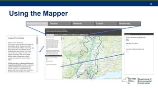
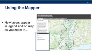
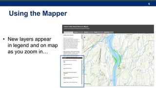
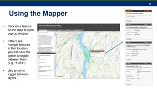
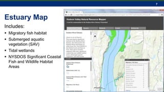
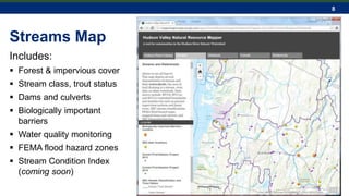
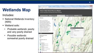
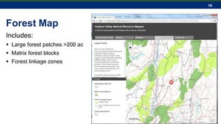
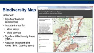
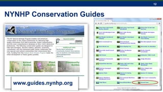
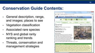
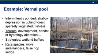
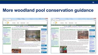
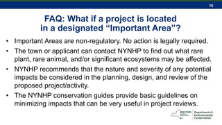
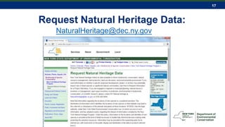
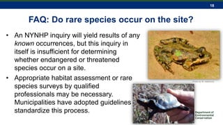
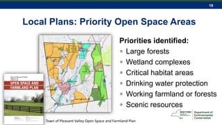
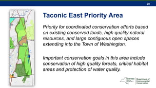
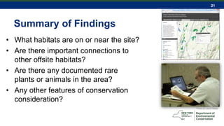
1
Ingrid Haeckel, NYSDEC Hudson River Estuary Program and Cornell University
Sean Carroll, Cornell Cooperative Extension of Dutchess County
Hudson Valley Natural Resource Mapper
2
www.hudson.dnr.cals.cornell.edu/mapper
3
Using the Mapper
4
Using the Mapper
• New layers appear
in legend and on map
as you zoom in…
5
Using the Mapper
• New layers appear
in legend and on map
as you zoom in…
6
Using the Mapper
• Click on a feature
on the map to open
pop-up window
• If there are
multiple features
at that location,
you will have the
option to toggle
between them
(e.g. “1 of 4”)
• Use arrow to
toggle between
layers
7
Estuary Map
Includes:
 Migratory fish habitat
 Submerged aquatic
vegetation (SAV)
 Tidal wetlands
 NYSDOS Significant Coastal
Fish and Wildlife Habitat
Areas
8
Streams Map
Includes:
 Forest & impervious cover
 Stream class, trout status
 Dams and culverts
 Biologically important
barriers
 Water quality monitoring
 FEMA flood hazard zones
 Stream Condition Index
(coming soon)
9
Wetlands Map
Includes:
 National Wetlands Inventory
(NWI)
 Wetland soils:
• Probable wetlands: poorly
and very poorly drained
• Possible wetlands:
somewhat poorly drained
10
Forest Map
Includes:
 Large forest patches >200 ac
 Matrix forest blocks
 Forest linkage zones
11
Biodiversity Map
Includes:
 Significant natural
communities
 Important areas for:
• Rare plants
• Rare animals
 Significant Biodiversity Areas
(SBAs)
 Audubon Important Bird
Areas (IBAs) (coming soon)
12
NYNHP Conservation Guides
www.guides.nynhp.org
13
Conservation Guide Contents:
- General description, range,
and images; places to see
- Vegetation classification
- Associated rare species
- NYS and global rarity
ranking and trends
- Threats, conservation and
management strategies
14
Example: Vernal pool
- Intermittently ponded, shallow
depression in upland forest;
sparsely vegetated, fishless
- Threats: development, habitat
or hydrology alteration…
- Strategies: wetland buffers
- Rare species: mole
salamanders, false hop
sedge Photo by Greg Edinger
15
More woodland pool conservation guidance
16
FAQ: What if a project is located
in a designated “Important Area”?
• Important Areas are non-regulatory. No action is legally required.
• The town or applicant can contact NYNHP to find out what rare
plant, rare animal, and/or significant ecosystems may be affected.
• NYNHP recommends that the nature and severity of any potential
impacts be considered in the planning, design, and review of the
proposed project/activity.
• The NYNHP conservation guides provide basic guidelines on
minimizing impacts that can be very useful in project reviews.
17
Request Natural Heritage Data:
NaturalHeritage@dec.ny.gov
18
FAQ: Do rare species occur on the site?
• An NYNHP inquiry will yield results of any
known occurrences, but this inquiry in
itself is insufficient for determining
whether endangered or threatened
species occur on a site.
• Appropriate habitat assessment or rare
species surveys by qualified
professionals may be necessary.
Municipalities have adopted guidelines to
standardize this process.
Photo by M. Adamovic
19
Local Plans: Priority Open Space Areas
Priorities identified:
 Large forests
 Wetland complexes
 Critical habitat areas
 Drinking water protection
 Working farmland or forests
 Scenic resources
Town of Pleasant Valley Open Space and Farmland Plan
20
Taconic East Priority Area
Priority for coordinated conservation efforts based
on existing conserved lands, high quality natural
resources, and large contiguous open spaces
extending into the Town of Washington.
Important conservation goals in this area include
conservation of high quality forests, critical habitat
areas and protection of water quality.
21
Summary of Findings
• What habitats are on or near the site?
• Are there important connections to
other offsite habitats?
• Are there any documented rare
plants or animals in the area?
• Any other features of conservation
consideration?
Photo by Laura Heady
22
Questions?
Connect with us:
Facebook:
www.facebook.com/NYSDEC
Twitter: twitter.com/NYSDEC
Flickr: www.flickr.com/photos/nysdec
Ingrid Haeckel
Conservation & Land Use Specialist
ingrid.haeckel@dec.ny.gov
Hudson River Estuary Program
and Cornell University
Photo by Laura Heady
Sean Carroll
Community Environmental Educator
smc427@cornell.edu
Cornell Cooperative Extension of
Dutchess County
23
Site Resource Analysis Assessment Checklist
Example from the Town of Rhinebeck
 stream and waterbody buffers?
 significant habitats or wildlife corridors?
 active farmland?
 scenic and historic resources?
 possible trail connections?
24
NYS Breeding Bird Atlas (2000-2005)
25
Black-and-White Warbler
Audubon Bird Conservation Guidance
26
New York Nature Explorer

Hudson Valley Natural Resource Mapper

  • 1.
    1 Ingrid Haeckel, NYSDECHudson River Estuary Program and Cornell University Sean Carroll, Cornell Cooperative Extension of Dutchess County Hudson Valley Natural Resource Mapper
  • 2.
  • 3.
  • 4.
    4 Using the Mapper •New layers appear in legend and on map as you zoom in…
  • 5.
    5 Using the Mapper •New layers appear in legend and on map as you zoom in…
  • 6.
    6 Using the Mapper •Click on a feature on the map to open pop-up window • If there are multiple features at that location, you will have the option to toggle between them (e.g. “1 of 4”) • Use arrow to toggle between layers
  • 7.
    7 Estuary Map Includes:  Migratoryfish habitat  Submerged aquatic vegetation (SAV)  Tidal wetlands  NYSDOS Significant Coastal Fish and Wildlife Habitat Areas
  • 8.
    8 Streams Map Includes:  Forest& impervious cover  Stream class, trout status  Dams and culverts  Biologically important barriers  Water quality monitoring  FEMA flood hazard zones  Stream Condition Index (coming soon)
  • 9.
    9 Wetlands Map Includes:  NationalWetlands Inventory (NWI)  Wetland soils: • Probable wetlands: poorly and very poorly drained • Possible wetlands: somewhat poorly drained
  • 10.
    10 Forest Map Includes:  Largeforest patches >200 ac  Matrix forest blocks  Forest linkage zones
  • 11.
    11 Biodiversity Map Includes:  Significantnatural communities  Important areas for: • Rare plants • Rare animals  Significant Biodiversity Areas (SBAs)  Audubon Important Bird Areas (IBAs) (coming soon)
  • 12.
  • 13.
    13 Conservation Guide Contents: -General description, range, and images; places to see - Vegetation classification - Associated rare species - NYS and global rarity ranking and trends - Threats, conservation and management strategies
  • 14.
    14 Example: Vernal pool -Intermittently ponded, shallow depression in upland forest; sparsely vegetated, fishless - Threats: development, habitat or hydrology alteration… - Strategies: wetland buffers - Rare species: mole salamanders, false hop sedge Photo by Greg Edinger
  • 15.
    15 More woodland poolconservation guidance
  • 16.
    16 FAQ: What ifa project is located in a designated “Important Area”? • Important Areas are non-regulatory. No action is legally required. • The town or applicant can contact NYNHP to find out what rare plant, rare animal, and/or significant ecosystems may be affected. • NYNHP recommends that the nature and severity of any potential impacts be considered in the planning, design, and review of the proposed project/activity. • The NYNHP conservation guides provide basic guidelines on minimizing impacts that can be very useful in project reviews.
  • 17.
    17 Request Natural HeritageData: NaturalHeritage@dec.ny.gov
  • 18.
    18 FAQ: Do rarespecies occur on the site? • An NYNHP inquiry will yield results of any known occurrences, but this inquiry in itself is insufficient for determining whether endangered or threatened species occur on a site. • Appropriate habitat assessment or rare species surveys by qualified professionals may be necessary. Municipalities have adopted guidelines to standardize this process. Photo by M. Adamovic
  • 19.
    19 Local Plans: PriorityOpen Space Areas Priorities identified:  Large forests  Wetland complexes  Critical habitat areas  Drinking water protection  Working farmland or forests  Scenic resources Town of Pleasant Valley Open Space and Farmland Plan
  • 20.
    20 Taconic East PriorityArea Priority for coordinated conservation efforts based on existing conserved lands, high quality natural resources, and large contiguous open spaces extending into the Town of Washington. Important conservation goals in this area include conservation of high quality forests, critical habitat areas and protection of water quality.
  • 21.
    21 Summary of Findings •What habitats are on or near the site? • Are there important connections to other offsite habitats? • Are there any documented rare plants or animals in the area? • Any other features of conservation consideration? Photo by Laura Heady
  • 22.
    22 Questions? Connect with us: Facebook: www.facebook.com/NYSDEC Twitter:twitter.com/NYSDEC Flickr: www.flickr.com/photos/nysdec Ingrid Haeckel Conservation & Land Use Specialist ingrid.haeckel@dec.ny.gov Hudson River Estuary Program and Cornell University Photo by Laura Heady Sean Carroll Community Environmental Educator smc427@cornell.edu Cornell Cooperative Extension of Dutchess County
  • 23.
    23 Site Resource AnalysisAssessment Checklist Example from the Town of Rhinebeck  stream and waterbody buffers?  significant habitats or wildlife corridors?  active farmland?  scenic and historic resources?  possible trail connections?
  • 24.
    24 NYS Breeding BirdAtlas (2000-2005)
  • 25.
  • 26.

Editor's Notes

  • #4 Toggle between thematic maps with 5 tabs at top of tool. On the top left sidebar of each thematic map there is a description of the layers included and some background into their ecological significance. Be sure to scroll down to read all of the text. The bottom left sidebar shows the legend for each thematic map…
  • #5 Many of the layers in these maps are “scale-dependent” What this means is that as the user zooms in on the map (either by using the +/- buttons on the top left of the map, or with the scroll wheel on your mouse), layers may add in or drop out.
  • #6 This happens to create a smooth, clear, and uncluttered view of the map.
  • #7 To view more specific attribute information pertaining to the features on the map, use your mouse to click on the polygon features. A pop-up window will appear. The popup will show all of the attribute information associated with that feature. For example, if you click on a polygon for the ‘Documented SAV Habitat’ layer, the pop-up window will show the size of that Submerged Aquatic Vegetation patch in acres (see top right box). Many times, the location you select on the map will fall within multiple feature layers in the thematic map. For example, at this location in Vanderburg Cove near Staatsburg, the map pulled up 4 different feature layers: SAV Habitat, Municipality, Significant Coastal Fish & Wildlife Habitat, and HUC-12 Watersheds. You can see this “(1 of 4)” in the top left of the pop-up window. To toggle in between the pop-up window attributes for each layer, use the arrows in the top right of the pop-up window.
  • #20 Some strategies for protection: Zoning and subdivision regulations Purchase of development rights Term conservation easements Landowner incentive programs
  • #21 Identified as a ‘Greenway Area’ of the Town by the 2009 Pleasant Valley Comprehensive Plan, the Taconic East Area lies along the Town’s eastern boundary and includes the land east of the Taconic State Parkway including the Washington Hollow hamlet area. Several public agencies and private organizations own large land holdings in this area thereby preserving a corridor of great beauty and environmental significance. From south to north, the NYSDEC Taconic Hereford Multiple Use Area, Rockefeller University Research Facility, Innisfree Foundation, and Cary Institute for Ecosystem Studies own and maintain thousands of contiguous acres of high quality forests and scenic meadows devoted to environmental research, resource management, and public recreation. These large open spaces continue east into the Town of Washington with many, very large single-ownership parcels and very low density. This area contains some of the most rugged land in the Town of Pleasant Valley. The general combination of steep slopes, shallow soils and exposed bedrock over much of the terrain makes the development of septic systems and foundations difficult. Road access is poor or non-existent to many areas. The Taconic East Area includes approximately 2,200 acres and has been designated a “Significant Area of Dutchess County” by the Dutchess County Environmental Management Council (DCEMC). This designation means that this area contributes significantly to the health, diversity, and enjoyment of the County’s resource base. This same area supports a variety of wildlife and as such, has also been designated by NYSDEC as New York State Significant Habitat. However, most privately owned parcels within this greenway area are not under any permanent development restrictions. It is this combination of existing conserved lands, high quality natural resources and large contiguous adjacent open spaces extending well to the east that makes this area particularly important for a coordinated conservation effort. This Plan recommends that the Town work to initiate partnerships and take steps to ensure that more lands within this greenway corridor are permanently protected.
  • #24 Some municipalities have formalized the type of resource analysis we have been practicing as part of a pre-application process or incorporated it into site plan or subdivision regulations. This helps to ensure a standard, fair procedure and make applicants aware of expectations. For example, the Town of Rhinebeck requires applicants to conduct a site resource analysis and developed a checklist and guidance for what to include. We included the resource analysis checklist in an appendix of the NRI guide and you have it in the back of your handout. The checklist could be equally useful during site plan review or other development review processes. In Rhinebeck, applicants create a resource analysis map following guidelines and complete the checklist, which is then verified by the planning board during subdivision review. This analysis is integral to the town’s “conservation design” or cluster development requirements – the map is used to ID important natural and cultural resources at the start of a project, and the development is then designed to avoid those areas and preserve them as open space.