Here are 5 methods to build a better future city:
1. Plant more trees - Trees help clean the air and provide shade. Planting trees along roads and in parks can improve air quality and living conditions.
2. Restrict pollution from factories - Factories should be required to use cleaner technologies and processes to reduce air, water, noise and chemical pollution. Strict limits and monitoring can protect public health.
3. Improve public transportation - Build subways, trains and bus networks to provide convenient transportation options and reduce traffic congestion and vehicle emissions. Well-connected public transit encourages less driving.
4. Create more parks and open spaces - Parks, gardens and other green spaces allow people to enjoy nature. They also
The document discusses themes related to urbanization and globalization through the case study of Tokyo, Japan. It provides details on Tokyo's large population and concentration of economic activity. It also examines Tokyo's aging population structure. Furthermore, it outlines Tokyo's 10-year plan to develop greenbelts, transportation infrastructure, and creative urban industries. Lastly, it discusses theories of urban form and the transition to consumer cities oriented around amenities rather than production.
This document is a report on creating a better livable town. It discusses the elements that make up towns and cities, including recreational areas, education areas, commercial sectors, and hospitals. It also examines what makes a good town, such as transportation systems, green spaces, drainage, and amenities. As a case study, it looks at the town of Oia in Greece. Oia is known for its white and blue cave houses and architecture, and tourism is a major part of its economy due to the preservation of its Greek architectural style.
This document provides information about Subang Jaya, a town in Malaysia. It begins with an introduction to the document and what will be covered. It then provides definitions and overviews of cities and towns. The document discusses the history and features of ancient Rome, present-day New York City, and a futuristic city of Glasgow. It also describes the town planning principles, guidelines for better future towns, and provides details about the zoning, residential and commercial areas of Subang Jaya. It concludes with a proposal to improve Subang Jaya.
AP Human Geography: Unit 7 - Urban Geography and DevelopmentDaniel Eiland
Unit 7 discusses key concepts in urban geography including:
1) Urban geography focuses on how cities function internally and are influenced externally. It studies city systems and internal city structures.
2) Urbanized areas contain cities located close together without clear boundaries. Metropolitan areas contain urbanized areas and surrounding commuting regions.
3) Louis Wirth defined cities as large permanent settlements with high density and social heterogeneity. Ancient cities served as centers of power, religion, education, and trade.
4) Pull factors that attracted rural migrants to cities included economic opportunities and infrastructure. World cities have global socioeconomic impacts while mega cities exceed 10 million people.
The document discusses a future city concept called the Floating PH Conditioner. It is a proposed skyscraper designed to prevent air pollution by floating above the city and using an air cleaning system. The structure would filter the air and produce byproducts like water and fertilizer to be used in city parks and gardens. The design received an honorable mention in the yearly Evolo Skyscraper competition for its innovative approach to addressing air quality issues from the sky.
The document is a report on a student project to design an improved livable town. It includes investigations of ancient, present and future towns, as well as an underwater town setting for the new proposed town. For the ancient town investigation, it describes the architecture and infrastructure of Pompeii and Babylon. For present towns, it provides details on Oslo, Norway including its history, economy, population growth and landmarks like the Ski Jump Tower. It also describes transportation systems in Tokyo. The report will be used to propose a new improved underwater town that incorporates sustainable and high-tech elements for comfortable future living.
The document discusses the evolution of cities from ancient times to the present. It describes the five original hearths of urbanization in ancient Mesopotamia, Egypt, Indus River Valley, China, and Mesoamerica. It then covers the growth of urban areas in Greece, Rome, Europe, and other parts of the world throughout history. The document also outlines models of urban development and John Borchert's four-stage model of American metropolitan evolution from the 18th to 20th centuries.
This document provides information about Chan Pei Shan's final project on representing future cities. It includes investigations of ancient, present and future cities, including Rome, New York City and Tokyo. It also includes a case study on a floating water city. Some key points are:
- Ancient Rome started as a trading hub and its accessible pathways inspired future city design.
- New York City has extensive public transport and walkways, encouraging greener transportation.
- Future Tokyo aims to be the world's greenest city with overhead transport and renewable energy.
- Floating water cities require consideration of economics, environment and social issues for long-term viability.
The document is a report on representing a future city. It includes investigations of ancient, present and future cities including the Maya city, Gangnam city in South Korea, and Songdo city, also in South Korea. For each city investigated, the document describes its history, what makes it significant, conclusions, and what elements could be used for the new future city being designed. It then discusses plans for a new city called ASPACHE, which will be a skyscraper city focusing on sustainability and technology with features inspired by the cities investigated in the report.
The document provides details about the ancient city of Tenochtitlan, the capital of the Aztec civilization founded in 1325. It describes the city's layout as built on an island in a lake, with a grid plan and connected to the mainland by three causeways. The center of the city contained large temples and plazas. It highlights the city's advanced water and agricultural systems, including aqueducts, dikes, and floating gardens called chinampas, which allowed the large population to be sustained. The document concludes by noting elements of Tenochtitlan's design that could be applied to the future city, such as its layout and structure centered around a large temple tower.
This document provides information about a student project to design a future city. It summarizes background on ancient cities like Venice for inspiration. It then discusses what defines cities in general, and what additional characteristics are needed to make cities great. The document suggests future cities may be underwater, underground, or powered by renewable energy. It analyzes the zoning and districts of Venice as a model and also discusses characteristics of the present-day city of Melbourne to inform the future city design.
The document discusses the definition and history of towns and urban growth. It defines a town as a permanent settlement that is the focus of inhabitants and economic activity, with a minimum population size that varies by country. Towns emerged around rivers and grew due to agricultural surpluses that allowed specialization of labor. Urban growth is influenced by factors like migration, economic development, location, and infrastructure. The process of urbanization refers to the concentration of people in urban areas and the social and economic changes that accompany this transition from rural to urban living.
This document provides an overview and introduction to a final project about better future towns. It begins with an introduction to the project requirements, which include investigating past, present, and future cities. It also discusses the requirement to propose guidelines for a better future town. The document then provides definitions of cities and towns. It includes examples of past, present, and future cities - Xi'an, Shanghai, and Hong Kong. It discusses the town planning principles of Broadacre City proposed by Frank Lloyd Wright. Finally, it introduces the topic of guidelines for better future towns that will be proposed.
WHY DO YOU NEET IT?
TO LEARN HOW TO TRANSFORM YOUR CITY AND COMMUNITY: THE SMART WAYS TO REDEVELOP EUROPEAN CITIES, RUSSIAN AGGLOMERATIONS, AND PERFORM INDIA’S “100 SMART CITIES” INITIATIVE OR CHINESE SMART AND GREEN CITIES DEVELOPMENTS
Urban geography is the study of how people use space in cities and how things are arranged in relation to each other. A city is defined functionally by what it does, not just by its size or population. It serves as the center of business and culture for a surrounding region. Elements of cities include suburbs, which touch the central city or other suburbs, and exurbs, which are smaller residential and commercial units farther from the main city. Land in cities is used for residential, industrial, and commercial purposes, and cities tend to develop near water access, at transportation intersections, or in sheltered areas that provide defensive positions or fuel and food supplies.
The document discusses urban design and its key principles and elements. It defines urban design as the process of designing and shaping cities, towns and villages, dealing with groups of buildings, streets, and public spaces at a larger scale than architecture. It outlines the differences between architecture, urban design, and urban planning in terms of scale, orientation, and time frames. The core elements of urban design discussed include buildings, public spaces, streets, transport, and landscape. Principles like character, continuity and enclosure, public realm, ease of movement, and diversity are also summarized.
The document discusses plans for a future underground city called Eco-City 2020 located in Siberia, Russia. It would be built inside an abandoned quarry covered by a glass dome. The city would have multiple levels, with housing, forests, farms, and recreation areas. It aims to provide an energy efficient underground living environment that conserves heat and protects residents from harsh weather. Elements that could be used for a new future city include the multi-level layout with a central core and outdoor spaces, as well as the glass dome covering that allows in sunlight.
The document discusses various models of urban land use and patterns of urban growth. It describes the stages of urbanization, from very slow growth to periods of rapid urban growth and suburbanization. Issues caused by rapid urban growth in LEDCs are also examined, such as insufficient housing and strain on services. Examples provided discuss efforts to improve quality of life in LEDC cities through better transportation, housing, and waste management.
The document summarizes a proposed future city called Food City in Dubai. It would be an off-grid, self-sufficient metropolis incorporating extensive sustainable urban planning ideas like vertically stacked landscape surfaces, renewable energy systems, and aquatic farms. These initiatives aim to decrease energy use and conserve water through techniques like atmospheric water harvesting, solar desalination, greywater recycling, and hydroponic agriculture. The proposal's goal is to marry landscapes and urbanism to create a model for sustainable, low-energy urban living that could inform future city development.
This document provides an analysis of the site conditions in Uptown Waterloo through a series of maps. The large context map shows the surrounding land uses and transportation connections. The buildings figure ground map depicts the solid forms and voids. Key observations include the irregular placement of buildings in the west and large voids in the center. A grid pattern is visible in the northeast section. Overall the maps provide insight into the existing built environment and open spaces.
The document provides an overview of an assignment to propose a future city as part of an Elements of Natural Built Environment course. It begins with an introduction describing the assignment requirements and background research conducted on sustainability, livable cities, and urban planning. Several sections then define what constitutes a city and discuss factors that make cities livable such as infrastructure, resources, transportation, and meeting people's needs. The document also examines examples of an ancient city of Shibam and the present-day capital of Malaysia, Kuala Lumpur, to understand city design principles. It concludes by stating that a future city needs to be sustainable to ensure stability and a better future for generations to come.
The document discusses a spatial analysis of the Detailed Area Plan (DAP) of Chittagong city in relation to its commercial and industrial land use and economic sustainability. It provides background on Chittagong's history as a port city and trade center. The research aims to examine how the DAP contributes to the city's economic sustainability through its land use designations and spatial configuration based on the theory of cities as movement economies. The methodology will analyze the physical city structures and land uses set out in the DAP and their ability to support a sustainable functional city from an economic perspective.
The development of urban underground space is fundamentally driven by urban economic changes and growth. As cities develop and populations increase, more space is needed to accommodate these activities. The rise of the tertiary economic sector, focused on producer services, strengthened core urban functions and compacted urban forms. High-rise office and commercial clusters transformed urban skylines and reflected evolving economic structures. When agglomeration economies matured sufficiently, underground space provided an important way to further expand urban capacity in a sustainable manner by relieving pressure on surface development. However, underground development must be considered in the context of a city's overall economic strategy and growth expectations to be sustainable over the long term.
enbe project 2 part A- town proposal report harrygirn
This document provides details about a student project to design a better livable town. It includes investigations of ancient, present and future towns to gather data and ideas. The student proposes a new town called WinderGrove, located on an island in Malaysia. WinderGrove would use a radial grid layout with various zoning areas. Transportation would primarily be by bicycle, bus and limited private vehicles. The town aims to be sustainable with renewable energy sources, green spaces and an automated waste disposal system.
This presentation covers major topics related to urban terminologies, issues faced in urban areas and how can those problem can be solved; as a example "Chandni Chowk" area of Delhi is explained.
Life and Career with works of Constantinos Apostolou Doxiadis. Theory of Urban Design presentation - CA Doxiadis : Ekistics theory, Islamabad master plan, Aspra Spitia introduction, Name of books and journals with bibliography
This document discusses a proposal for a new policy regarding education standards for children in hospitals. It notes that currently, home school coordinators work with hospitalized children but their education may not meet all of their developmental needs. The proposed policy would combine elements of the No Child Left Behind Act and the Family Medical Leave Act to improve education for hospitalized children. It analyzes the impact of current policies on families and children, finding that hospitalized children often fall behind academically due to lack of support from both hospitals and school districts.
Acta de acuerdo pedagógico viabilidad del desarolloManuel Bedoya D
Este documento presenta el acta de acuerdo pedagógico de una asignatura de la Universidad Cooperativa de Colombia. Se detallan los puntos tratados en la reunión como la presentación del docente y estudiantes, la misión y visión de la universidad, la filosofía de la educación a distancia, las orientaciones metodológicas, estrategias de evaluación y acuerdos generales.
This document discusses planning in management. It defines planning as determining future courses of action in advance. Planning is important for managers to determine opportunities, anticipate problems, develop strategies, and understand uncertainties. There are different types of planning like strategic, tactical, operational, and contingency planning. The planning process involves analyzing objectives, developing strategies, evaluating alternatives, selecting a course of action, and implementing and reviewing plans. Principles and advantages of planning are also outlined.
O livro 'Boneco de Neve Sorridente' de M. Christina Butler. Sugestão de leitura para o alunos do Pré - Escolar. Alguns temas a explorar: animais que vivem em paisagens com neve, inverno, roupas de inverno, brincadeiras de neve, amizade.
Foxy es una francotiradora de élite. Foxy y su unidad de fuerzas especiales y francotiradores se han desplegado a la costa de Somalia para combatir a los piratas que han estado atacando y secuestrando barcos en esta región. Apunta con el puntero rojo al pirata. Pulsa espacio y se activa la mira telescópica. Mientras más tiempo tengas pulsado la barra espacio más te acercarás al pirata. Dispara y mata a todos en cada misión. Tu misión es vital. Debes detener a los piratas a toda costa y poner fin a su influencia sobre las rutas marítimas internacionales. Varias misiones diferentes que tendrás que pasar y liberar los barcos secuestrados para poner fin a los piratas en la costa de Somalía.
Un patito feo nace en un nido con patitos más bonitos. Debido a su apariencia diferente, es rechazado y se burlan de él. Decide irse solo y enfrentar los desafíos del invierno.
I am currently working as a piping design engineer at Heatkal technologies in Pune. I have over 1 year of experience in piping design and have worked on projects for corn-based ethanol plants. I am proficient in AutoCAD, PDMS, and CAESAR II from my post-graduate studies in piping design engineering. I also have a bachelor's degree in mechanical engineering. My key responsibilities include preparing piping drawings, equipment layouts, reports, and bills of materials.
Witness - for Christ with the example of Bl. Chiara BadanoDerrick Augustin
This is a ppt on Witness. Its a very important topis in today's world as Christians. What people long to see is witness and they want inspiration to be taken into their lives. I have also given the example of Bl. Chiara Badano, an italian teenager who lived a witnessing life for Christ and who also diagonsed with bone cancer. I think this ppt will surely help.
God blez u
- Derrick, C.Ss.R.
The document provides information about the CW television network and the teen drama series 90210 that aired on the network. It establishes that the CW was formed in 2006 as a joint venture between CBS and Warner Bros. and aimed to attract youth audiences aged 15-30. It then provides details about the series 90210, including that it was set in Beverly Hills and focused on the lives of college students, covering topics like relationships, bullying, and pregnancy. It also analyzes how gender is portrayed in the series through the appearances and behaviors of the main male and female characters.
Este documento describe una sesión de aprendizaje sobre la investigación acción pedagógica. La sesión se enfoca en identificar y enunciar problemas de investigación, y elaborar un árbol de problemas. Los estudiantes trabajan en grupos para identificar problemas en sus prácticas educativas, formular un enunciado de problema, y construir un árbol que muestre las causas y efectos del problema. Al final, se evalúa el trabajo de los estudiantes usando listas de cotejo y escalas de estimación.
Everything you ever wanted to know about the Certified Meeting Professional (CMP) designation is covered in this session: its history, its structure and organization, and how the program has evolved. Included will be tips on the application process, studying, and how to survive test day.
The document outlines some common codes and conventions of teen films and thriller films that could be incorporated into the opening sequence of a hybrid teen/thriller film. For teen films, it notes the use of extreme stereotypical characters, cliques, typical props like phones and cars, settings like high schools and malls, and common themes of love, arguments, and bullying. For thriller films, it discusses using brave protagonists, unknown antagonists seeking revenge, close-ups and quick cuts to build tension, sinister mise-en-scene elements, suspenseful music, and noir techniques like shadows and cliffhangers. The hybrid opening would draw from both genres' conventions to set up the teen and mystery elements
Análisis Profundo de la;
NORMA OFICIAL MEXICANA NOM-003-SSA2-1993,
"Para la disposición de sangre humana y sus componentes con fines terapéuticos".
Resaltando sus incisos mas importantes desde un punto critico y objetivo de una forma simple.
St hack2015 dynamic_behavior_analysis_using_binary_instrumentation_jonathan_s...Jonathan Salwan
Abstract: This talk can be considered like the part 2 of my talk at SecurityDay. In the previous part, I talked about how it was possible to cover a targeted function in memory using the DSE (Dynamic Symbolic Execution) approach. Cover a function (or its states) doesn't mean find all vulnerabilities, some vulnerability doesn't crashes the program. That's why we must implement specific analysis to find specific bugs. These analysis are based on the binary instrumentation and the runtime behavior analysis of the program. In this talk, we will see how it's possible to find these following kind of bugs : off-by-one, stack / heap overflow, use-after-free, format string and {write, read}-what-where.
El documento lista los miembros de un club deportivo y el número de salidas que realizaron cada mes durante el año, así como su clasificación en la temporada. Se enumeran 17 miembros con sus salidas mensuales y la suma total de cada uno, liderando la clasificación Jose M Alcaucin con 27 salidas y en segundo lugar Manolo Periana con 18 salidas.
landscape ideas for gulshan lake, dhakaSaad Mostafa
this was the wining entry for a national student idea competition in Bangladesh. requirements were to give ideas about what can be done along the water edges of GULSHAN lake in dhaka
The document provides details about the town of Puchong, including its history and characteristics. It discusses what defines a town versus a city, and provides examples of medieval and current cities. It also explores the concept of satellite towns and futuristic cities, using Brasilia and Dubai as case studies. The key aspects of town planning for Brasilia are outlined, including its transportation system and landscaping features.
This document provides an overview of a final project to design a new, better town called Zerone. It begins with introductions and definitions of towns. It then discusses investigations and data collection on ancient, present, and future towns. For ancient towns, it examines the Sassi of Matera. For present towns, it looks at Paris. For future towns, it analyzes Masdar City in Dubai as an example of a planned zero-carbon city. The document concludes by stating this research will help understand key elements of towns and what makes them better and sustainable.
This document provides information about human settlements and the characteristics of cities. It discusses the different types of urban plans like grid, linear and radial plans. It describes the main functions of cities like residential, commercial, industrial, and cultural. The document also covers the morphology and structure of cities, including city centers, peri-urban areas, and outskirts. It examines the historical evolution of cities from antiquity to the modern age. In addition, it discusses the relationship between cities and their surrounding territories in the urban hierarchy.
The document discusses a future city representation project for a class. It begins by introducing the project which asks students to pretend they are the mayor of an existing city ("X" city) that needs to be relocated due to issues. Students must propose a new layout for the city, which could be underground, underwater, floating, or enhanced.
It then provides background information on cities in general, what defines and makes a good city, and defines a future city. It also includes sections summarizing investigations into aspects of ancient Roman cities and data collected about present day London, looking at population, culture, infrastructure, and issues facing inner versus outer London.
The document is an A4 booklet about Kajang Town in Malaysia produced by a student for their final project. It provides definitions and information about towns and cities in general, including their key characteristics and differences. It then discusses the ancient city of Athens in Greece, highlighting features like the Acropolis. The present city of Shanghai, China is also examined, noting areas like the Bund, Nanjing Road, and Yuyuan Garden. The future city of Tianjin Eco-City, a joint China-Singapore project, is briefly described as well. In under 3 sentences, the summary captures the main purpose, scope and key topics covered in the original document.
The document discusses several ancient and modern cities as potential sources of inspiration for designing a future livable town. It examines the Aztec city of Tenochtitlan in depth, highlighting aspects of its infrastructure like its system of canals, aqueducts, and chinampas (floating gardens). These elements effectively addressed issues of transportation, water management, and lack of land for agriculture. The document considers incorporating chinampas, an organized centralized layout, and underground water channels into the proposed new town design.
The document discusses the ancient city of Tenochtitlan, which was the capital of the Aztec Empire located in modern-day Mexico City. It flourished between 1325-1521 AD and was built on an island in Lake Texcoco, with a complex system of canals and causeways. The city had sophisticated water and drainage systems that supplied hundreds of thousands of residents. It was largely destroyed by Spanish conquistadors in 1521.
This document discusses key aspects of cities and urban settlements. It begins by noting that while definitions of cities vary, some common characteristics are a large population, tall buildings close together, and economic activities focused on secondary and tertiary sectors like industry and services. Rural settlements, in contrast, have lower populations and focus on primary sectors like agriculture. The document then examines common functions of cities like residential, commercial, industrial, and political uses. It also explores urban morphology and the different patterns cities can take, like grids, radial plans, and irregular forms. Finally, the internal structure of cities is discussed, differentiating city centers, peri-urban areas on the outskirts, and further outskirts where newer development is located.
The document discusses the planning of a new town called the "Infinity City". It begins with an introduction where the author states they will pretend to be the mayor proposing a new layout for the town. It then provides summaries of research conducted on ancient, present and future towns. This includes details on layouts, transportation, green spaces and sustainability features. The document concludes by stating a new "Infinity Town" will be proposed incorporating elements learned from the research.
A global city is an urban center that serves as an important hub in the global economic system. Global cities have characteristics like international influence, major airports and transportation systems, diverse cultures and communities, influential financial and media institutions, advanced communications infrastructure, vibrant culture and entertainment scenes, and world-renowned universities and cultural institutions. Examples of top global cities according to recent reports include New York, London, Paris, Tokyo, Hong Kong, Los Angeles, Singapore, Chicago, Beijing, and Brussels based on current performance, and San Francisco, New York, London, Paris, Singapore, Amsterdam, Munich, Boston, Houston, and Melbourne based on future potential.
The document discusses definitions of rural and urban settlements. It states that while definitions of cities vary, some key characteristics that define urban areas are a large population, tall buildings close together, and an economy focused on secondary and tertiary industries like manufacturing and services. Rural areas, in contrast, have a lower population and focus on primary industries like agriculture. The document also examines different types of urban plans like grids and the main functions of cities like residential, commercial, and industrial activities.
The document discusses key concepts related to cities and urban settlements. It defines what constitutes a city versus rural settlements, noting factors like population size, building density, and economic activities. Main functions of cities are also outlined, including residential, commercial, industrial, and administrative uses. Different urban plan types are described like grid, linear and radial patterns. The internal structure of cities is also examined, distinguishing city centers, peri-urban areas, and outskirts.
This document presents a report on a proposed new town called Valor Town. It begins with an introduction describing the project requirements to propose a new town layout. It then provides investigations and data collection on ancient, present and future towns. This includes details on the Roman town of Calleva Atrebatum and its grid system, the present German town of Kirchsteigfeld and its open green spaces, and the English town of Ludlow and its eco-park and historic preservation. The document then describes the key characteristics of the new Valor Town, such as its gridiron system, central plaza, parks, and distribution of facilities. It concludes by reflecting on lessons learned about sustainable town planning and layout hierarchies.
This document presents a report on a project to design a new, better livable town. It begins with an introduction to the project requirements and objectives. It then provides investigations and data collection on ancient, present and future towns. This includes details on the Roman town of Calleva Atrebatum and the present town of Kirchsteigfeld, Germany. It also examines the future town of Ludlow, England. Drawing from these case studies, the document then describes the new proposed town of Valor Town. It outlines important characteristics and elements of the new town design, such as a gridiron system, green spaces, and facilities. The conclusion reflects on lessons learned from the project around sustainable town planning and layout.
This document presents a report on the planning and design of a new town called Valor Town. It includes investigations of ancient, present and future towns to inform the design. Ancient Calleva Atrebatum is analyzed for its grid layout and hierarchy. The present German town of Kirchsteigfeld incorporates large green spaces. The future town of Ludlow, England balances heritage and sustainability. Valor Town will apply these lessons, with a gridiron system, central plaza, parks, and green spaces throughout to encourage walking. While more can be improved, the student learned the importance of hierarchy and sustainability in town planning.
This document outlines the planning process for a new town called Valor Town. It begins with an introduction describing the project requirements. It then provides background research on the definitions of towns/cities, guidelines for livable towns, and case studies of ancient, present and future towns. Specifically, it examines the Roman town of Calleva Atrebatum, the German town of Kirchsteigeld, and the English town of Ludlow. It then describes the key characteristics and elements of the new Valor Town, which is planned based on a gridiron system and includes amenities like parks, plazas and sports centers connected by a river transportation system. The conclusion states the new town will have livability benefits based on this planning process
This document provides details about a final project report for a class on natural and built environments. It includes an introduction to the project, which involves proposing a new layout for a fictional city called "X City". The report then discusses the definition of a city and provides a brief history of cities. It also examines what makes a good city and explores elements of ancient, present and future cities that could be applied to the new city design. Specifically, it analyzes the ancient city of Athens and the present city of Chicago, highlighting planning elements and sustainability features of each.
The document discusses definitions of cities and how they differ from rural settlements. It states that while definitions of cities vary, some common aspects that distinguish cities are their large population size, concentration of tall buildings close together, and economies focused on secondary and tertiary sectors rather than primary sectors like agriculture. Cities are also characterized by their various functions such as residential, commercial, industrial, tourist, political/administrative, and cultural activities. The morphology and structure of cities is also covered, discussing different urban plan patterns and how cities are organized with a center, surrounding peri-urban areas, and outer outskirts.
Fp part a - report template (recovered)Lynette Law
The document presents a proposal for a future floating city called Hoffen City. It discusses investigating existing and ancient cities to inform the design. Key elements extracted include Copenhagen's extensive bicycle infrastructure for transportation within the new city. The floating design is intended to shelter citizens from natural disasters like earthquakes and tsunamis. The proposal includes zoning maps that divide the circular city into areas for residences, businesses, recreation, farms, and military defense.
The document provides information about the ancient city of Cahokia Mounds and the present city of Amsterdam. Some key details:
- Cahokia Mounds was a large, complex pre-Columbian Native American city located in modern-day Illinois near St. Louis, Missouri from around 600-1400 CE. It covered around 6 square miles and had around 120 earthen mounds, including Monks Mound, the largest in North America.
- Amsterdam is the capital of the Netherlands, located in the province of North Holland. It has a population of over 825,000 within city limits. The city has over 100 km of navigable canals that divide it into islands linked by over 1,
This document announces the winners of the 2024 Youth Poster Contest organized by MATFORCE. It lists the grand prize and age category winners for grades K-6, 7-12, and individual age groups from 5 years old to 18 years old.
The cherry: beauty, softness, its heart-shaped plastic has inspired artists since Antiquity. Cherries and strawberries were considered the fruits of paradise and thus represented the souls of men.
❼❷⓿❺❻❷❽❷❼❽ Dpboss Kalyan Satta Matka Guessing Matka Result Main Bazar chart Final Matka Satta Matta Matka 143 Kalyan Chart Satta fix Jodi Kalyan Final ank Matka Boss Satta 143 Matka 420 Golden Matka Final Satta Kalyan Penal Chart Dpboss 143 Guessing Kalyan Night Chart
Heart Touching Romantic Love Shayari In English with ImagesShort Good Quotes
Explore our beautiful collection of Romantic Love Shayari in English to express your love. These heartfelt shayaris are perfect for sharing with your loved one. Get the best words to show your love and care.
Boudoir photography, a genre that captures intimate and sensual images of individuals, has experienced significant transformation over the years, particularly in New York City (NYC). Known for its diversity and vibrant arts scene, NYC has been a hub for the evolution of various art forms, including boudoir photography. This article delves into the historical background, cultural significance, technological advancements, and the contemporary landscape of boudoir photography in NYC.
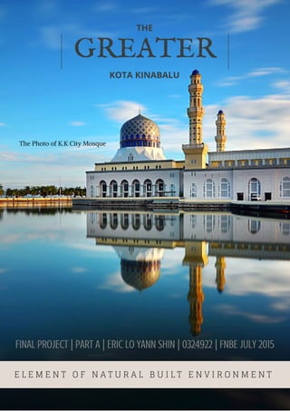
1. GREATER
THE
KOTA KINABALU
E L E M E N T O F N A T U R A L B U I L T E N V I R O N M E N T
FINAL PROJECT | pARt A | ERIC LO YANN SHIN | 0324922 | FNBE JULY 2015
The Photo of K.K City Mosque
2. iNSIDE
City
1| what is city
1|advantages and disadvantages
Past, Present & Future
2-3| Athen, Greece / municipalities
4-5| Manhattan, New York / Five boroughs
6-7| Dubai, Futuristic city / temperature-
controlled city
Town Planning Principle
8| Characteristic / stages
9| Facts
Better Future Town Guildelines
11| The five methods
Kota Kinabalu/ The City I Live In
12| Overview
13| Zoning of Kota Kinabalu/legend/ overall
info
14| Residential Areas
15| Public Buildings
16| Public Open Spaces
17| Commercial Areas
18| Government Buildings
20| Education Areas
22| Transportation Hubs
23| Religious & Cultural Areas
25| Facilities, Amenities & Infrastructures.
26| Conclusion/ Synthesis/ Vision
3. iNSIDE
Proposal for a better future city
28| Identifying Present cities condition
29| Ideals/ Future Dense City
Appendix
30| websites/pictures
4. CITYA CITY IS A LARGE TOWN AND PERMANENT HUMAN
SETTLEMENT WHICH COMPOSED OF DIFFERENT BUILDINGS
AND ACTIVITIES IN A DISTRICT.
Over one million people are added to the world’s cities
every week. News reports on the subject frequently
rephrased this development slightly to say that half of the
global population now lives in the cities. By 2050, two-
third of the human population will be urban.
Cities generally have complex systems for sanitation,
utilities, land usage, housing, and transportation. Once a
city expands far enough to reach another city, this region
can be deemed a conurbation or megalopolis, for
example, New York City and surrounding areas including
Long Island.
A city formed as central places of trade for the benefit of
the members living in close proximity to others facilitates
interaction of all kinds. These interactions generate both
positive and negative externalities between others'
actions.
Therefore, city's density leads to efficiencies in meeting
your needs. Cities serve as a site for the exchange of
labour, money, entertainment, culture, and are transit
hubs. You can live in a city with less stuff than in the
country, and your life can be richer through easy access to
other people and culture.
ADVANTAGES DISADVANTAGES
Reduced transport costs Higher rate of crime
Exchange of ideas Higher cost of living
Large local markets High commuting times
Sharing of natural resources Higher cost of living
5. ANCIE
NT
PRES
ENT
FUTU
RE
ATHEN, GREECE
ATHENS IS THE CAPITAL AND LARGEST CITY IN GREECE
IS ONE OF THE WORLD’S OLDEST CITIES HAS BEEN INH
ABITED 3000 YEARS AGO.
URBAN AND SUBURBAN MUNICIPALITIES
The earliest buildings date from the late Bronze
Age estimated 1200-1300BC, and one of the
earliest civilization
Athens sprawls across the central plain of Attica that is often
referred to as the Athens or Attica Basin. The basin is
bounded by four large mountains: Mount Aegaleo to the
west, Mount Parnitha to the north, Mount Penteli to the
northeast and Mount Hymettus to the east.Beyond Mount
Aegaleo lies the Thriasian plain, which forms an extension of
the central plain to the west. The Saronic Gulf lies to the
southwest.
Athens sprawls across the central plain of
Attica that is often referred to as the Athens
or Attica Basin.The basin is bounded by four
large mountains: Mount Aegaleo to the
west, Mount Parnitha to the north, Mount
Penteli to the northeast and Mount
Hymettus to the east. Beyond Mount
Aegaleo lies the Thriasian plain, which
forms an extension of the central plain to
the west. The Saronic Gulf lies to the
southwest.
CITY OF ATTICA BASIN
Athen City was built in
grid plan form
The Buildings are gridded consistently
6. ANCIE
NT
PRES
ENT
FUTU
RE
MUNICIPALITIES OF GREATER ATHENS
Central Section:
1. City of Athen
s
2. Dafni
3. Ilioupoli
4.Vyronas
5. Kaisariani
6. Zografou
7. Galatsi
8. Filadelfeia
West Section:
29. Egaleo
30. Agia Varvara
31. Chaidari
32. Peristeri
33. Petroupoli
34. Ilion
35. Agioi Anargyroi
– Kamatero
North Section:
9. Nea Ionia
10. Irakleio
11. Metamorfosi
12. Lykovrysi – Pefki
13. Kifissia
14. Penteli - Melissia
15. Amarousio
16. Vrilissia
17. Ag. Paraskevi
18. Cholargos –
Papagou
19. Chalandri
20. Filothei –
Psychiko
South Section:
21. Glyfada
22. Elliniko-
Argyroupoli
23. Alimos
24. Agios Dimitrio
s
25. Nea Smyrni
26. Faliro
27. Kallithea
28. Moschato
Ancient Buildings of Athen
acropolis
Olympia
ERECHTHEION TEMPLE
7. NEW YORK, USA
ANCIE
NT
PRES
ENT
FUTU
RE
The most popular city in United States.
Manhattan is the centre of
the New York metropolitan
area. It is one of the most
popular urban
agglomerations in the world.
The population of New York
city is about 8.4 Million. It
consists of fiver boroughs.
The 5 boroughs in NYC:
1. Manhattan
2. Brooklyn
3. Queens
4. The Bronx
5. Staten Island
The borough hosts many world-
renowned bridges, skyscrapers, and
parks..
Manhattan's Chinatown incorporates the
highest concentration of Chinese people in the
WesternHemisphere
Many districts and landmarks in Manhattan
have become well known, as New York City
receives millions of tourists and hosts
Manhattan three of the world's 10 most-
visited tourist attractions in 2013 are Times
Square, Central Park, and Grand Central
Terminal.
8. Manhattan was built
in gridded form plan
Buildings in Manhattan
Empire
state
Building
One
world
trade
centre
Metropolitan Museum of Art
ANCIE
NT
PRES
ENT
FUTU
RE
9. DUBAI, UAE
ANCIE
NT
PRES
ENT
FUTU
RE
Dubai is the most popular city in United Arab Emirate. It is also the
fastest growing city in the world which has a rich collection of
buildings and structure of various architectural styles. Due to the
burst of construction, Dubai has acquired various building-related
records, which include: the world's tallest tower (Burj Khalifa), the
world's largest shopping mall (Dubai Mall), the world's largest
fountain (The Dubai Fountain) and the world's tallest hotel (JW
Marriott Marquis Hotel Dubai).
Burj khalifa, tallest
skyscraper in the
world.
829.8m
high
The Futuristic Dubai
Dubai is one of the most highly potential
developing city. There are a number of
large-scale projects which are currently
under construction or will be constructed in
the future. Due to the heavy construction
which is taking place in Dubai, 30,000
construction cranes, which are 25% of
cranes worldwide, are operating in Dubai.
The future development plan follows the
vision of Shaikh Mohammed Bin Rashid Al
Maktoum.
Shaikh Mohammed
Bin Rashid Al
Maktoum “The Ruler
of Dubai”
10. THE WORLD'S FIRST TEMPERATURE-
CONTROLLED CITY IN DUBAI
10 years of construction to build "The
Mall of The World" ANCIE
NT
PRES
ENT
FUTU
RE
In the future, when our home planet is covered in man-
m a d e w a s t e , w e a l l m i g h t l i v e i n c l i m a t e -
c o n t r o l l e d , p e r f e c t l y m a n i c u r e d b i o - d o m e s .
Plans unveiled by developers
show intent to build an entire
indoor city in Dubai, complete
with retractable glass roof in what
is being billed as the world’s
largest shopping centre.
The city's capacity will be large
enough to accommodate 180
million visitors each year in 100
hotels and serviced apartment
buildings
Glass-roofed streets,
modelled on New York's
Broadway and London's
Oxford Street, will stretch for
7 km. These will be air-
conditioned in summer as
temperatures soar above 40°C
The plan also provisions for a 3 mil
lion square feet wellness centre, a
cultural celebration district, servic
ed apartments, and a wide selecti
on of hospitality.
11. THE CONCEPT OF
SATELLITE TOWN
Satellite town or satellite city is a concept in urban
planning that refers essentially to miniature metropolitan
areas on the fringe of larger ones.
CHARACTERISTIC
Satellite cities are small or medium-sized cities near a large
metropolis area, that:
-Predate that metropolis' suburban expansion
-Are at least partially independent from that metropolis economically and socially
-Are physically separated from the metropolis by rural territory; satellite cities should have
their own independent urbanized area, or equivalent;
-Have their own bedroom communities;
-Have a traditional downtown surrounded by traditional "inner city" neighborhoods
-May or may not be counted as part of the large metropolis' Combined Statistical Area.
Founder
Introduced by Graham Romeyn
Taylor in 1915.
Stages of Satellite Town
12. Facts
Larger central cities
have two inclinations;
one toward
centralization and
another toward
decentralization. .
Satellite Cities present as a
residential district, a school
town or an industrial city, a
functional share of the large
central cities. Citizens of the
satellite city are closely tied
together with its central city
in their daily life.
The satellite city is an
intermediate unit between
the large city and the local
city. It is semi-independent.
Satellite city has a
population both going-out
and coming-in.
Satellite cities
structurally consist of old
districts which were
formerly the city areas,
and the new districts
which have newly been
annexed and expanded
into suburban areas.
Conclusion
The mismatch between living and
employment in the new towns became the significant problems that constrained their
future development. In this dissertation, this kind of phenomenon will be called “Spatial Mismatch” and will be
further elaborated in next section.
Petaling Jaya is a major Malaysian city
originally developed as a satellite township for
Kuala Lumpur. It is located in the Petaling
district of Selangor with an area of
approximately 97.2 square kilometres.
Petaling Jaya was granted city status on 20
June 2006.
The layout concept of satellite city which include
residential area, commercial area, industrial area,
agriculture area and railiway
13. GUILDELINES
BETTER FUTURE CITY
The living conditions in our city are getting worse. Exhaust fumes and
smoke from the factories are polluting the air and trees are being cut
down. Furthermore, the river is being polluted by chemicals from the
factories and people are suffering from breathing difficulties and stomach
problems. Therefore, we should use more green ways to improve our cities
to be even more livable and sustainable.
14. Green spaces, quiet streets and recreational parks are
important for relaxation, health and sport, nature watching
and social activities. Open areas and green parks are
important building blocks for promoting quality of life in
urban environments.
It is vitally important for our cities and towns to function
efficiently and to lower the use of scarce natural resources,
to achieve a sustainable quality of life for citizens now and into
the future.
Well-governed cities and towns that involve their citizens in
environmental decision-making will lead to better
planning for the future and help to ensure the sustainability of
the systems we create.
Clean and safe drinking water, effective wastewater
treatment, clean
air, and proper waste disposal are basic elements for a high
quality of
life in the cities.
Encourage to build more green buildings which are
constructed by biomaterials or use recyclable
materials such as steel formwork, recycled insulation,
low voc (Volatile organic compounds) paint and etc.
as well as revolutionize the cityscape.
The Five Methods
15. Kota Kinabalu
Sabah
The cityi live in
Sabah is the second largest
state in Malaysia.The land area
of Sabah is approximately equal
to the combined land area of
Selangor,
Pahang, Johor, Melaka, and
Negeri Sembilan.
Kota Kinabalu is formerly known as
Jesselton. It is the largest city and capital of
the state of Sabah. The city is located on the
northwest coast of Borneo facing the South
China Sea.
Sabah indeed has one of the highest
population growth rates in the country.
The area of the city is 351 km². The
city population is 452,940. The density
of the city is 1,290/km² and Granted
city status on
Feb 2, 2000.
Kota Kinabalu Population Projection 2005-2030
16. Zoning of kota kinabalu
Kota Kinabalu is considered a small city which is still
underdevelopment. This city granted its city status on
February 2, 2000.
Overall Information
1. Residential areas – 25
2. Public buildings – 3
3. Public open spaces – 12
4. Commercial areas – 19
5. Government buildings – 13
6. Education areas – 18
7. Transportation hubs – 2
8. Religious and cultural areas – 7
9. Facilities, amenities &
infrastructure – 4
10. Industrial areas – 4
11. Undeveloped areas – 9Total area of Kota Kinabalu is 135.5 mi²
The tale of
k.k
The stomach of
k.k
The head of
k.k
Legend:
Boundary of k.k
Residential areas
Public Buildings
Public open spaces
Commercial areas
Government Buildings
Education areas
Transportation hubs
Religious & cultural
areas
Facilities, amenities
& infrastructure
Undeveloped lands
Industrial areas
17. Residential Areas
A residential area is a land use in which housing predominates, as
opposed to industrial and commercial areas.
1
The whole area
is named
Kingfisher
which consists
different
range of
houses, such
as single
storey terrace
houses, double
storey terrace
houses, three
storey terrace
houses, Semi-
detached
houses and
bungalow
houses. It is
considered one
of the most
expensive
property in
Kota Kinabalu.
1
2
2
It is known as
“floating
village” where
all the house
are built
along the
waterfront
and the
material used
are timbers.
Ranging from medium –
high cost housing.
Old housing area
18. Public Buildings
A “public building” is defined as a place where members of
the public usually or occasionally assemble. The assembly
must be a more formal than fortuitous collection of people.
1
Sabah State Library
1
2
2
Sabah Muzeum
3
3
Likas stadium
Which hosted
Sukan Malaysia
11th in 2002
19. Public Open Spaces
A public space is a social space that is generally open and
accessible to people. Roads, public squares, parks and
beaches are typically considered public space.
1
2
1
Perdana Park Tanjung Aru
2
Tanjung Aru Beach
3
4
3
KK Bird Sanctuary
4
Likas Sport Complex
20. Commercial Buildings
A commercial building is a building that is used for commercial use. Types can
include office buildings, warehouses, retail stores or hotels.
1
1
Gaya street
It is a street market only open during
every Sunday morning.
2
2
One Borneo Hypermall
Is the largest shopping mall in
Kota Kinabalu.
3
3
Sutera habour resort
is a 5-star hotel that
built beside the sea
shores.
21. Government Buildings
Government building generally means a building for a
“government department”, as a government building must
be owned by a government department
1
1
Queen Elizabeth Hospital1
is the main hospital in Kota
Kinabalu
2
2
The Yayasan Sabah Tower
is known as Menara Tun
Mustapha tower. It is the
second tallest building in
the island of borneo.
23. Education Buildings
a building designed for various activities in a primary,
secondary, or higher educational system and often including
living areas for students, such as dormitories.
1
1
SMK Lok Yuk, Likas is my
secondary school which takes
about 15 to 20 minutes drive from
my house (Penampang.)
My house
24. 2
SJK (c)Shan Tao is my primary
school which take 6-8 drive
from my house.
2
My house
3
University Malaysia Sabah is
the ninth Malaysian Public
University located in kota
kinabalu and was established
on 24 November 1994
3
25. Transportation Hubs
A transport hub is a place where passengers and
cargo are exchanged between vehicles or between
transport modes. Public transport hubs include train
stations, rapid transit stations, bus stops, tram stop,
airports and ferry slips.
1
1
Kota Kinabalu International
Airport is an international
airport in Kota Kinabalu. It
is located approximately 8
km southwest of the city
centre and the second
busiest airport in Malaysia.
2
2
Jesselton Point is a ferry or
boat terminal to different
islands.
26. Religious and cultural
areas
Religious area or buildings is a place of worship
is a specially designed structure or consecrated
space where individuals or a group of people
such as a congregation come to perform acts of
devotion, veneration, or religious study.
While a cultural area refers
to a geographical area with
one relatively homogeneous
human activity or complex of
activities (culture).
1
1
Kota kinabalu city
mosque. This mosque
cost Rm 34 Million and
has the capacity of
12,000.
27. 2
Secret Heart Cathedral is
the main Roman Catholic
Church in Kota Kinabalu.
3
3
National Department for
Culture and Arts is one of
the agencies under Ministry
of Tourism and Culture
Malaysia and it is
responsible in implementing
cultural and arts activities
in Malaysia.
28. Facilities, Amenities &
Infrastructure
refers to the fundamental facilities and
systems serving a country, city, or area,
including the services and facilities
necessary for its economy to function.
1
1
Sabah Electricity Sdn.
Bhd is an electrical
company that generates,
transmits and distributes
electricity mainly in Sabah
and Federal Territory of
Labuan.
2
2
Telekom Malaysia Berhad
is a Malaysia
telecommunication
services. This is kota
kinabalu’s headquater.
29. Conclusion
Kota Kinabalu is a small city which is currently under a major
development. As the capital city of Sabah, Kota Kinabalu has a lot of
potential lands and spaces for improvement. Thus, it is very essential
for us to understand the current conditions of the city in order for
us to identify and improve the natural and built environment of the
city.
Populations
According to researches, Sabah
is one of the highest population
growth rates in Malaysia. Today,
the property in Kota Kinabalu is
constantly inflating and when the
populations increases in the
future some of the citizens might
have difficulty in finding a
shelter. Therefore, government
and developers should take this
issue into concern in order to
design or build affordable
houses for different category
income of citizens.
Transportations
The public transports
in Kota Kinabalu is
limited because there
are only public
transport such as
shuttle bus is
available in the city.
Plus, the shuttle bus
does not operate
efficiency. For
example, the
inconsistency of time
schedules and bus are
not reachable or
provided in some part
of the city.
Undeveloped lands
There are many empty lands can be
found within the city which are
abandoned. Government and
developers should make this lands
into something useful to serve the
community so that the resources of
the city can be maximize.
Current condition and synthesis of k.k city:
Vision and objective of k.k structure plan 2030:
1.Develop Kota Kinabalu as the nature resort
and maritime city.
2. Provide good and efficient infrastructure
facilities.
3. Promote environmental sustainable design.
4. Improve and upgrade local living standard.
30. By 2050, three out of four peoples
on earth will be living in cities.
Some cities will look more like
Amsterdam or Singapore, but
they’ll all face similar challenges as
the pressure to manage energy,
water, and food becomes more
urgent than ever. Because with
higher population rate come more
homes, businesses,
commuters, consumers and etc. But
new technologies and innovative
approaches to urban planning are
driving sustainable solutions
worldwide, making cities cleaner
and more attractive places to live.
Thus, it is critically important to
plan for a better city.
CITY
Proposal for the
better future
31. Identifying the present cities condition
City are the largest producer of carbon emissions, what can
do to make it greener or in other words how can we build the
ideal city?
Well, it all comes down with one thing, that is density which
turns out more people in less spaces, isn’t always a bad thing
because dense is more .
1. environmentally friendly transportation
Increase the usage of public transportation especially
Commuter, intercity, and high-speed rail which are
reachable and effective in every part of the city. Expert
have claimed that by using effective public transport, it
can reduce the usage of private vehicles used for about
1000 miles per person per year. Therefore, it enables the
city to reduce pollution and minimize the usage of fuel.
Brief ideals of proposing a future dense city
2. strategic and coordinated in the use of land.
In a dense city, there are still a lot of spaces, all we
need to do is to be more creative. For example,
Manhattan has an estimated 30 square mile unused roof
space which is 20 times the size of central park of New
York. Thus, we should manipulate these space wisely in
order to serve the community.
32. 3. energy efficiency
A compact city can be more energy
efficiency. Power planting for one can be
a lot smarter which they can be
connected to smart grid which allows the
wasted energy to get used. That means
there is less pollutions and cheaper
utilities bills.
Conclusion
However, no city is an ideal city and we cannot
just re-design everything by scratch. The cities
must adaptable, but, ideals do provide a share
sense of direction. Even if where we ended up it is
only partial, at least we can see how far we can
go. In conclusion, during the process we will build
a better and more sustainable future city for us
to live.