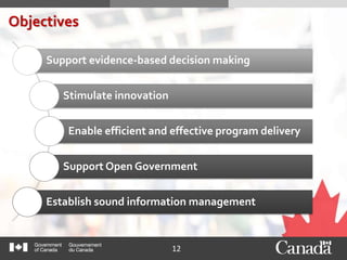
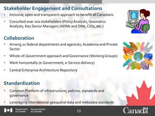
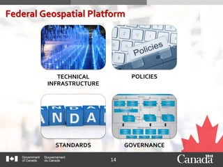
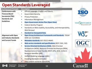
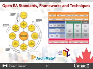
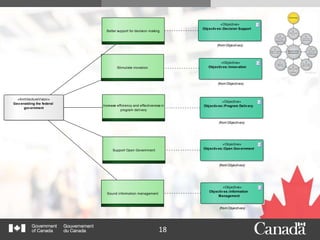
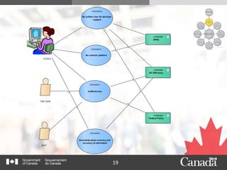
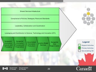
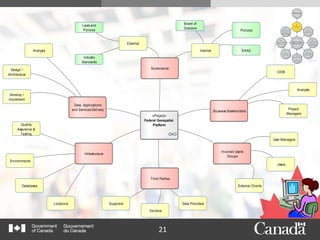
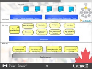
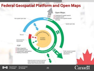
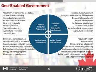
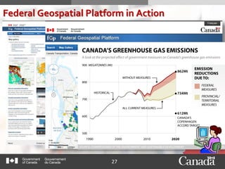
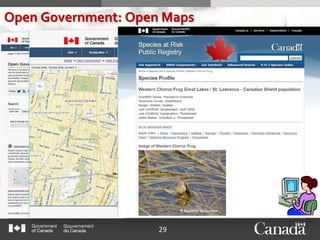
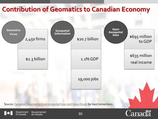
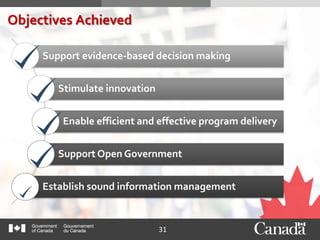
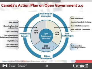
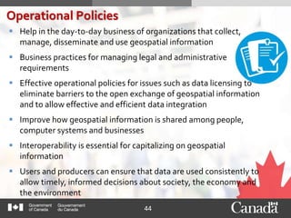
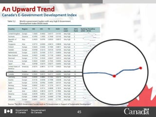
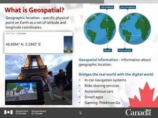
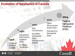
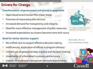
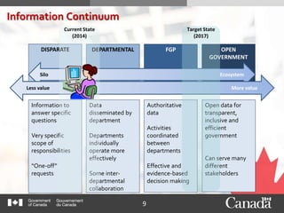
The document discusses Canada's Federal Geospatial Platform (FGP), which was created in 2014 to better manage and share geospatial data across the Canadian federal government. The FGP uses open standards and a collaborative approach to make geospatial data discoverable, usable, and interoperable among 21 federal departments and agencies. This has supported more evidence-based decision-making, program delivery, and open government. The vision is for Canada's government to be fully "geo-enabled" through continued investment in the FGP and open data.
Presented by Melanie Bacou, IFPRI and Todd Slind, Spatial Development International at the Africa RISING–CSISA Joint Monitoring and Evaluation Meeting, Addis Ababa, Ethiopia, 11-13 November 2013
Data Harvesting, Curation and Fusion Model to Support Public Service Recommen...Gayane Sedrakyan
CITADEL is a H2020 European project that is creating an ecosystem of best practices, tools, and recommendations to transform Public Administrations (PAs) via an inclusive approach in order to provide stakeholders with more efficient, inclusive and citizen-centric services. The CITADEL ecosystem will allow PAs to use what they already know plus new data to implement what really matters to citizens in order to shape and co-create more efficient and inclusive public services. CITADEL innovates by using ICTs to find out why citizens stop using public services, and use this information to re-adjust provision to bring them back in. Also, it identifies why citizens are not using a given public service (due to affordability, accessibility, lack of knowledge, embarrassment, lack of interest, etc.) and, where appropriate, use this information to make public services more attractive, so they start using the services.
The DataTank, a tool designed and developed by IMEC’s IDLab, will be extended to provide the Data Harvesting/Curation/Fusion (DHCF) component of the platform. The DataTank provides an open source, open data platform which not only allows publishing datasets according to standardised guidelines and taxonomies (DCAT-AP), but also transforms the data into a variety of reusable formats. The extension will include an intelligent way of harvesting and fusion of different data sources using semantics and Linked Data mapping technologies developed by IDLab. In the context of CITADEL the new HCF component will enable the visualization and analysis of trends for the usage of public services in European cities, playing a key role in generating personalized recommendations to the citizens as well as to PAs in terms of suggesting improvements to the current suite of public services.
Data Harvesting, Curation and Fusion Model to Support Public Service Recommen...Citadelh2020
CITADEL is a H2020 European project that is creating an ecosystem of best practices, tools, and recommendations to transform Public Administrations (PAs) via an inclusive approach in order to provide stakeholders with more efficient, inclusive and citizen-centric services. The CITADEL ecosystem will allow PAs to use what they already know plus new data to implement what really matters to citizens in order to shape and co-create more efficient and inclusive public services. CITADEL innovates by using ICTs to find out why citizens stop using public services, and use this information to re-adjust provision to bring them back in. Also, it identifies why citizens are not using a given public service (due to affordability, accessibility, lack of knowledge, embarrassment, lack of interest, etc.) and, where appropriate, use this information to make public services more attractive, so they start using the services.
The DataTank, a tool designed and developed by IMEC’s IDLab, will be extended to provide the Data Harvesting/Curation/Fusion (DHCF) component of the platform. The DataTank provides an open source, open data platform which not only allows publishing datasets according to standardised guidelines and taxonomies (DCAT-AP), but also transforms the data into a variety of reusable formats. The extension will include an intelligent way of harvesting and fusion of different data sources using semantics and Linked Data mapping technologies developed by IDLab. In the context of CITADEL the new HCF component will enable the visualization and analysis of trends for the usage of public services in European cities, playing a key role in generating personalized recommendations to the citizens as well as to PAs in terms of suggesting improvements to the current suite of public services.
https://twitter.com/Citadelh2020
https://twitter.com/gayane_sedraky
https://twitter.com/imec_int
https://twitter.com/IDLabResearch
Workshop II on a Roadmap to Future GovernmentSamos2019Summit
In this session we proceed to presentations and discussion concerning the the development of the new roadmap for digital government. Two projects (Gov3.0 roadmap and Big Policy Canvas) will join forces in this exciting endeavor.
Organizers: Maria Wimmer, Professor, Koblentz University, Germany; Francesco Mureddu, Associate Directorr, Lisbon Council, Belgium; Juliane Schmeling Fraunhofer Institut FOKUS, Researcher, Germany; Shoumaya Ben Dhaou, Researcher, United Nations University, PT
Open Government Data: What it is, Where it is Going, and the Opportunities fo...OECD Governance
Keynote presentation given by Ryan Androsoff (Digital Government Policy Analyst, OECD) at the 2015 EUROSAI-OLACEFS conference in Quito, Ecuador on 25 June 2015. Focus of the presentation is on Open Government Data and the opportunities for Supreme Audit Institutions presented by open data. Video of the presentation is available at: https://youtu.be/SlBfxmecJhI?t=1h50m19s
For more information on OECD's work relating to Open Government Data please see: http://www.oecd.org/gov/public-innovation/open-government-data.htm
This report was prepared for the City of Syracuse by a Masters of Public Administration class at the Maxwell School of Citizenship and Public Affairs at Syracuse University. The team consisted of Jinsol Park, Dan Petrick, Krishna Kesari, Sarah Baumunk, and was overseen by Jesse Lecy.
Research data management and the Digital Curation CentreMartin Donnelly
Slides from a couple of webinars given while visiting ANDS in Canberra, Australia. (N.B. We also gave short talks at Statistics New Zealand and Monash University - the slides are more or less the same.)
UN Global Pulse works to implement and
promote opportunities to use big data
innovations for development and humanitarian
action. This report summarizes Global Pulse’s
2016 innovation activities for sustainable development
and humanitarian action.
An update from the "Exploring the open data Initiative of the Ministry of Finance on National Budget Transparency in Indonesia" project in Indonesia (http://www.opendataresearch.org/project/2013/si)
Big Data for Development and Humanitarian Action: Towards Responsible Governa...UN Global Pulse
This report presents a summary of the main topics discussed by the PAG in general, which were mainly summarized during the
2015 PAG meeting. It also describes some of the outcomes that came out of the PAG meeting of 23-24 October 2015.
ODDC Context - Open government data for regulation of energy resource industr...Open Data Research Network
Presentation in the first workshop of the Exploring the Emerging Impacts of Open Data in Developing Countries project. Looking at the context of open data, and the research case study planned for 2013 - 2014. See http://www.opendataresearch.org/project/2013/teri
Программа повышения квалификации "Инновационные подходы к управлению медицинс...Vshouz
Высшая школа организации и управления здравоохранением. Программа повышения квалификации "Инновационные подходы к управлению медицинской организацией". Продолжительность - 36 академических часов.
Современные технологии управления медицинской организацией: процессный подход к управлению медицинской организацией, моделирование и реинжиниринг процессов в медицинской организации, выявление «критических процессов» в медицинской организации с применением современных методов анализа, LEAN-менеджмент в здравоохранении.
Управление персоналом медицинской организации: динамика поведения в группе, организационная культура,эффективный контракт в здравоохранении
Mobile marketing from analysis to launching a projectHeads&Hands
Stages of launching your app with various technics and metrics to measure the impact of your application. Promotion plan, ads examples, analytical tools, etc.
Recompilación de haikus e microrrelatos elaborados polo alumnado do CPI de Pontecesures baseándose en fotos súas do contorno nas que se aprecian distintos tipos de tempo. O traballo foi organizado dende as aulas de Lingua e Literatura Galegas e o ENDL do centro para o Plan Proxecta de Meteoroloxía.
Keynote, Oman Geospatial Expo, Dec 2013Steven Ramage
Invited by Geospatial Media and Oman National Survey Authority (NSA) to deliver overview of current activities relating to international geospatial standards, including ongoing work through United Nations initiative on Global Geospatial Information Management (UN-GGIM).
In recent years governments and research institutions have emphasized the need for open data as a fundamental component of open science. But we need much more than the data themselves for them to be reusable and useful. We need descriptive and machine-readable metadata, of course, but we also need the software and the algorithms necessary to fully understand the data. We need the standards and protocols that allow us to easily read and analyze the data with the tools of our choice. We need to be able to trust the source and derivation of the data. In short, we need an interoperable data infrastructure, but it must be a flexible infrastructure able to work across myriad cultures, scales, and technologies. This talk will present a concept of infrastructure as a body of human, organisational, and machine relationships built around data. It will illustrate how a new organization, the Research Data Alliance, is working to build those relationships to enable functional data sharing and reuse.
David Coleman presentation at SDI Summit 2014, Calgary, Canada, 17-19 Sept 2014GSDI Association
Keynote presentation at Pan-Canadian SDI Summit 2014 by GSDI Association President David Coleman entitled "International SDI Initiatives: Thinking Globally, Acting Locally”. After providing context on the role Canadians played in early land information networking and SDI developments through the 1980s and early 1990s, he described the importance of such transnational and international SDI initiatives as Digital Earth, GEO, OGC & ISO, UN GGIM and — with special emphasis on the GSDI Cookbook and Small Grants Program — the GSDI Association itself.
The term “Spatial Data Infrastructure” (SDI) is often used to denote the relevant base collection of technologies, policies and institutional arrangements that facilitate the availability of and access to spatial data. SDI describes the overall methodology, process, existing practice, terms, policies of Nepal.
Some slides about the state of open data in Australia. These are updated regularly so please keep an eye on this slideshare account for the latest slides.
Using linked data and the semantic web - "powered by INSPIRE" conference pres...Alex Coley
The central commitment of the UK Government to Open Data and Open Data Standards has continued and this has built towards the desire to not only publish data in ways that are open but to do this with data that isin a way that is both useful and structured in a way that is useful. This has necessarily focused on both enabling innovation and improving public sector efficiencies. The UK Government Linked Data Working Group (UKGovLD) was formed as a commitment in the Open Data white paper, and grew from an UK INSPIRE Linked Data Working Group. UKGovLD is here to advise UK Government on the implementation of Linked Data technologies and associated business practices, highlighting areas of best practice and identifying projects that should be prioritised or amended. All to enable collaboration and the delivery of core projects for the benefit of the UK.
Presented at the:
Canadian Aviation Safety Collaboration Forum
International Civil Aviation Organization (ICAO)
Montreal, QC
January 23, 2019
This presentation was made in real-time while attending the Forum. The objective was to observe and listen, and share some examples outside of this community that may provide insight about data sharing models with a focus on governance.
1. 1
Leveraging Open Standards to Achieve Objectives
Making Standards Work® - e-Government
The Open Group Paris 2016
2. 2
Synopsis
In 2012, the Canadian Federal Committee on Geomatics and Earth Observations (FCGEO)
recognized a need for a common platform of technical infrastructure, policies, standards,
and governance to manage geospatial information assets in a more efficient and
coordinated way among its 21 federal departments and agencies.
In 2014, led by the Natural Resources Canada’s (NRCan) Canada Centre for Mapping and
Earth Observation (CCMEO), the Federal Geospatial Platform (FGP), a collaborative
online environment consisting of authoritative geospatial data, services, and applications
was created.
Today, the FGP plays a key role in bringing together the government’s economic, social
and environmental data to better support location-based decision making on a range of
complex issues, such as responsible resource development, environmental management,
regulatory reviews, and safety and security.
This presentation aims to discuss the barriers to information sharing in the
e-Government open data and open collaboration context, and to describe the specific
suite of open standards, frameworks and policies that were key to overcoming those
barriers towards better information sharing and interoperability.
5. 5
What is Geospatial?
Geographic location - specific physical
point on Earth as a set of latitude and
longitude coordinates.
Geospatial information - information about
geographic location.
Bridges the real world with the digital world
In-car navigation systems
Ride-sharing services
Autonomous cars
Smart apps
Gaming: Pokémon Go
6. 6
Power of Perspective
Map layer references a
dataset
Symbols and text labels
2D/3D
Spatial trends and
relationships emerge
Insight about relevant
characteristics of a
location
8. 8
Transformation of government and citizen engagement
Open Government Action Plan (Open Data)
Promises of improved public services
Increased demand for transparency and integrity
Need for more effective management of public resources
Increased expectations as citizens become more tech-savvy
Drivers for Change
Need for better decision support
No unified view to support effective decision making
Inefficiencies, duplication of efforts in program delivery
Limited use of geospatial data in policy and decision-making
Uncertainty of information's currency and accuracy
Inability to share and interoperate between departments
Meet Candice. She is an
Environmental Policy Analyst.
9. 9
Information Continuum
DISPARATE DEPARTMENTAL FGP OPEN
GOVERNMENT
Silo Ecosystem
Less value More value
Information to
answer specific
questions
Very specific
scope of
responsibilities
“One-off”
requests
Data
disseminated by
department
Departments
individually
operate more
effectively
Some inter-
departmental
collaboration
Authoritative
data
Activities
coordinated
between
departments
Effective and
evidence-based
decision making
Open data for
transparent,
inclusive and
efficient
government
Can serve many
different
stakeholders
Target State
(2017)
Current State
(2014)
11. 11
Vision
"The federal government is geo-enabled."
'Geo-Enablement (n):
1. Embedding and leveraging the power of location and geography
within workflows and business processes.
2. The act of deriving and utilising geography within non-spatial
information.
3. The state of being enabled using location information.' [1]
12. 12
Objectives
Support evidence-based decision making
Stimulate innovation
Enable efficient and effective program delivery
Support Open Government
Establish sound information management
13. 13
Stakeholder Engagement and Consultations
Inclusive, open and transparent approach to benefit all Canadians
Consulted over 100 stakeholders (PolicyAnalysts, Geomatics
Analysts, Key Senior Managers (ADMs and DMs, CIOs, etc.)
Collaboration
Among 21 federal departments and agencies, Academia and Private
Sector
Whole-of-Government approach and Governance (Working Groups)
Work horizontally (e-Government, e-Service delivery)
Central EnterpriseArchitecture Repository
Standardization
Common Platform of infrastructure, policies, standards and
governance
Leveraging international geospatial data and metadata standards
16. 16
Open Standards Leveraged
Architectural Principle Description
Conformance with
Treasury Board
Secretariat (TBS)
Standards and
Guidelines
Official Languages (English and French)
Government Security
Privacy Protection
Information Management
Open Government Action Plan (Open Data)
Federal Identity Program
Standards on Web Usability, Accessibility, and Interoperability,
Web Renewal
Standard on Geospatial Data
Alignment with Open
and Industry Standards
and Current Trends
Open Group Architecture Frameworks and Standards: TOGAF
ADM and ArchiMate
Metadata standards (ISO 19115 HNAP)
Web service standards and specifications (REST, OGC, ISO)
Service-Oriented Architecture (SOA), Web-Oriented
Architecture (WOA), Resource Oriented Architecture (ROA),
Representational State Transfer (REST) APIs, W3C, Uniform
Resource Identifier (URI)
Unified Modeling Language (UML)
Encoding Standards (Unicode)
Data content standards (GeoJSON)
18. 18
Better support for decision making
Stimulate inovation
Increase efficiency and effectiveness in
program delivery
Support Open Government
Sound information management
«Objective»
Objectives::Decision Support
(from Objectives)
«Objective»
Objectives::Innovation
(from Objectives)
«Objective»
Objectives::Program Delivery
(from Objectives)
«Objective»
Objectives::Open Government
(from Objectives)
«Objective»
Objectives::Information
Management
(from Objectives)
«ArchitectureVision»
Geo-enabling the federal
government
Architecture Vision
19. 19
FCGEO
«Concern»
No common platform
TBS CIOB
«Concern»
Inefficiencies
«Interest»
Utility
«Interest»
GC Efficiency
«Interest»
Federal Policy
IM/IT
«Concern»
Uncertanty about currency and
accuracy of information
«Concern»
No unified view for decision
support
Conceptual Framework
20. 20
alue chain Value Chain Diagram
Shared Services Infrastructure
Geospatial
Data
Dissemination
Location-Based
Services
Geospatial
Information
Capture and
Processing
Value-Added
Information
Production
Geospatial
Information
Analysis and
Presentation
Leveraging and Contribution to Science, Technology and Innovation (STI)
Support Activities
Primary Activities
Geo-enabling GC
Legend
Leadership, Collaboration and Coordination
Compliance to Policies, Strategies, Plans and Standards
21. 21
«Project»
Federal Geospatial
Platform
Buisness Stakeholders
Involved Users/
Groups
Data, Applications
and Services Delivery
Third Parties
Infrastructure
Governance
External
Internal
Laws and
Policies
Industry
Standards
Policies
EAAG
Quality
Assurance &
Testing
Environments
Databases
Locations Suppliers
Vendors
Data Providers
User Managers
Users
External Clients
CIOB
Analysts
Project
Managers
Design /
Architecture
Develop /
Implement
Analysis
Board of
Directors
Project Context Diagram
22. 22
Intranet Extranet Internet Mobile
Channels
Process/
WorkFlow Engine
Geospatial Data
Collection
Data Storage and
Management
Geospatial Data
Purchase
Data Dissemination and
Publishing
Data Management
GCGeo - Federal Geospatial Platform
Middleware
Front Office
Mid Office
Back Office
Open Maps on Open Government Portal
Search & Discovery
Catalogue
AnalyticsVisualization
Data Dissemination
Repository
Collaborative
Mapping
Environment
Web Services &
Publishing
Help Desk
APIs
23. 23
uc Primary Use Cases
System Boundary
Search and Discover
Visualize and Analyze
Access Data
Store and Manage Data
«Actor»
Expert User
Publish Data
«Actor»
GC User
Access Control
Text Search
Faceted Search
Spatial Search
View
View Dataset
View Metadata
Visualize Data
Publish Metadata
Publish Data
Services
Metadata Publishing
Workflow
Manage Data
Manage Metadata
Collaboration
«Actor»
Developer
Re-Use
«include»
«Invokes»
«include»
«include»
«include»
«include»
«include»
«include»
«include»
«include»
«include»
«include»
«include»
«extend»
26. 26
Infrastructure investment
Indigenous community development
Transportation networks
Labour development
Sustainable aquaculture
Forestry innovations
Agricultural risk management
Agricultural innovation
Population health
Marine safety
Climate change adaptation
Geo-hazard monitoring reporting
Environmental emergency response
National disaster mitigation program
Public health infrastructure and network
Food safety information network
Environmental assessment
Wildlife and habitat protection
Greenhouse gas emission regulation
Fishery monitoring and regulation
Pollutants monitoring and regulation
Energy efficiency programs
Clean energy development
Weather/environmental prediction
Stream flow monitoring
Groundwater geoscience
Fishery stock assessment
New energy supply
Mineral potential
State of biodiversity
Agricultural resources
State of forests
Geo-Enabled Government
Natural
Resource
Assessment
Economic
and
Community
Development
Public Safety
and Security
Environment.
Stewardship
30. 30
Contribution of Geomatics to Canadian Economy
Source: Canadian Geomatics Environmental Scan andValue Study by GeoConnections
2,450 firms
$2.3 billion
Geomatics
Firms
$20.7 billion
1.1% GDP
19,000 jobs
Geospatial
Information
$695 million
to GDP
$635 million
real income
Open
Geospatial
Data
31. 31
Objectives Achieved
Support evidence-based decision making
Stimulate innovation
Enable efficient and effective program delivery
Support Open Government
Establish sound information management
33. 33
"Canadians need to have faith in their government’s
honesty and willingness to listen.That is why we
committed to set a higher bar for openness and
transparency in Ottawa.
Government and its information must be
open by default.
Simply put, it is time to shine more light on
government to make sure it remains focused on the
people it was created to serve – you.
-The Right Honourable JustinTrudeau, Prime Minister of
Canada
Source: http://open.canada.ca/en/content/third-biennial-plan-open-government-partnership
34. 34
Canada's Action Plan on Open Government 2.0
Source: Canada's Action Plan on Open Government 2014-16
35. 35
Future Commitment
Source: http://open.canada.ca/en/content/third-biennial-plan-open-government-partnership
Increase the Availability and Usability of Geospatial Data
The Government of Canada will make more high-quality, authoritative, and
useable geospatial data available in open formats to support innovation and
better services to Canadians
Open maps will support progress towards a modern, networked, and tech-
enabled society
It will ensure effective program delivery, improve services to Canadians, and
support them in their day-to-day activities
Source: http://open.canada.ca/en/content/third-biennial-plan-open-government-partnership
Commitment 13: Increase the Availability and Usability of Geospatial Data
“The Government of Canada will continue to unlock the potential of open data
through a series of innovative and forward-looking projects that drive government-
wide progress on open data and prioritize easy access to high-value federal data.”
37. 37
Key Takeaways
Start with a Vision that everyone can rally behind, set
realistic objectives and have a plan to achieve them
Engage, motivate and galvanize user community early
Work horizontally across sectors and departmental lines
in an ecosystem
Collaborate and create partnerships
Standardize on leveraging Open Standards to make
geospatial data discoverable, usable and re-usable
Align with Principles andVision
39. 39
Our Coordinates
David Harper
Director
Federal Geospatial Platform Secretariat
Natural Resources Canada | Government of Canada
+ 1 613 694 2542
david.harper@canada.ca
Bilyana Anicic
President | Principal Consultant
Aurora Consulting
+ 1 613 620 3052
bilyana@auroraconsulting.ca
https://ca.linkedin.com/in/bilyanaa
Prashant Shukle
Director General
Canada Centre for Mapping and Earth Observation
Natural Resources Canada | Government of Canada
+1 613 759 7244
prashant.shukle@canada.ca
41. 41
Context
GeoConnections
GeoConnections is a national program with the mandate and responsibility to lead the Canadian
Geospatial Data Infrastructure (CGDI) through standards and the use of applied innovations and
technologies for data sharing and integration. GeoSecretariat fosters cooperation between groups to
collaboratively build the CGDI.
FederalCommittee on Geomatics and Earth Observations
The Federal Geospatial Platform (FGP) is an initiative of the Federal Committee on Geomatics and
Earth Observations (FCGEO), a committee of senior executives from 21 departments and agencies
Innovation and Renewal in the Public Service
Collaborative approach to managing geospatial data assets more effectively while supporting the
Government of Canada as a modern, technology-enabled organization.
Other Open Data Initiatives
European Union: INSPIRE
United Kingdom: data.gov.uk and Ordnance Survey
United States: data.gov
Australia: data.gov.au
Canada: open.canada.ca
42. 42
The Open Group
The Open Group standards and frameworks leveraged include:
TOGAF® framework
ArchiMate®
SOA Reference Architecture
Open Geospatial Consortium (OGC)
The OGC (Open Geospatial Consortium) is an international not for profit organization committed to
making quality open standards for the global geospatial community.These standards are made through
a consensus process and are freely available for anyone to use to improve sharing of the world's
geospatial data.
International Organization for Standardization (ISO)
A series of standards to describe geographic information, including:
Geospatial or Geographic data and information are defined in the ISO/TC 211 series of standards as
data and information having an implicit or explicit association with a location relative to the Earth.
ISO 19115:2013Geographic Information, the North American Profile (NAP), and ISO 19110 Feature
Catalogue.
ISO 19139 for geospatial data and information.
References
43. 43
FGP virtually centralizes disparate data sources by
describing geospatial data and services in a consistent
manner (HNAP) in a common catalogue and enabling
their search and discovery from a single interface through
open.canada.ca.
Makes data discoverable, usable and understandable.
Supports data discovery and data documentation.
Standardized metadata set for describing geospatial
data to facilitate integration.
Over time, the use of standards will lead to the
coordinated development, use, sharing, and
dissemination of geospatial data.
Metadata
44. 44
Help in the day-to-day business of organizations that collect,
manage, disseminate and use geospatial information
Business practices for managing legal and administrative
requirements
Effective operational policies for issues such as data licensing to
eliminate barriers to the open exchange of geospatial information
and to allow effective and efficient data integration
Improve how geospatial information is shared among people,
computer systems and businesses
Interoperability is essential for capitalizing on geospatial
information
Users and producers can ensure that data are used consistently to
allow timely, informed decisions about society, the economy and
the environment
Operational Policies
45. 45
Source: The UN E-Government Survey 2016 on “E-Government in Support of Sustainable Development”
An Upward Trend
Canada’s E-Government Development Index
Editor's Notes
Making Standards Work® - e-Government
The Open Group Paris
October 24, 2016
Introduction
What is Geospatial?
Synopsis
Impetus and Vision
Information Dissemination Continuum
Goals and Objectives
Approach
Architectural Principles
Making Standards Work
Open Standards and Techniques Leveraged
Selected EA Artefacts
Objectives Achieved
FGP and Open Government
FGP Today
Goals and Objectives Achieved
Vision of the Future
Key Takeaways and References
Questions
Candace
Policy Analyst at the Canadian Environmental Assessment Agency (CEA)
Geospatial information — or, at its simplest, information about location — has revolutionized how we see the world and our place in it.
It tells us where on Earth different things are, and how they relate to one another.
The data used in digital maps, in-car navigation systems, autonomous cars, or something as simple as an address directory, are all examples of geospatial information.
With its popularity and our increasing dependency on it, making geospatial information accessible is critical to today’s connected world.
Using geospatial information can boost economic growth.
Information Layering
Context:
GeoConnections
GeoConnections is a national program with the mandate and responsibility to lead the Canadian Geospatial Data Infrastructure (CGDI) through standards and the use of applied innovations and technologies for data sharing and integration. GeoSecretariat fosters cooperation between groups to collaboratively build the CGDI.
Federal Committee on Geomatics and Earth Observations
The Federal Geospatial Platform (FGP) is an initiative of the Federal Committee on Geomatics and Earth Observations (FCGEO), a committee of senior executives from 21 departments and agencies
Innovation and Renewal in the Public Service
Collaborative approach to managing geospatial data assets more effectively while supporting the Government of Canada as a modern, technology-enabled organization.
Other Open Data Initiatives
European Union: INSPIRE
United Kingdom: data.gov.uk and Ordnance Survey
United States: data.gov
Australia: data.gov.au
Canada: open.canada.ca
The transformation of government and citizen engagement in the 21st century includes open data. The promises of improved public services, increased public integrity, and more effective management of public resources are materializing.
Limited access to geospatial data and information products for policy and decision-making, inefficiencies, including duplication of efforts, and users' uncertainty of data's currency and accuracy.
Inability to share and interoperate between departments without duplicating efforts and having to store other departments' data has caused a situation where there is no unified view to support effective decision making.
Common Directive on Geospatial Information Management
Common Data Strategy
Security
Enterprise Licensing
Benefits Realization: The FGP may achieve its technical, data and policy goals but there must be client uptake for the project to be successful. Communication of the benefits of FGP within partner departments is slow and targeted users currently have little knowledge of FGP.
Candice – Policy Analyst
Transformation
The FGP is helping Government of Canada to realize its vision by moving the public service towards a modern, geo-enabled organization that manages its data assets more effectively to support decision-making as well as beginning the process to innovate service delivery, realize operational efficiencies and increase internal productivity.
Goals and Objectives
Better support for decision making
Enable data collected by government scientists, surveyors, state-of-the-art sensors and satellites via antenna ground stations to be integrated, shared and analyzed with other relevant sources of data across the federal family and made available on the desktops of interest groups and to the public via the internet.
Provide the ability to quickly visualize large amounts of data in a Canadian context (e.g., on regional maps within Canada) to identify correlations, trends, and communicate complex ideas more clearly in the decision-making process.
Stimulating Innovation
By providing easy access to the government’s geospatial information, visualization tools and analytics, allow public, private, and academic sectors to create new value to stimulate economic development across a diverse range of economic sectors and spur technological innovation.
Increasing Efficiency and Effectiveness in Program Delivery
Enable ability to search once for desired information and find all essential information related to the search, rather than going to multiple departments and agencies for the information.
Coordinate an approach to geomatics to reduce duplication of efforts in the acquisition and management of geospatial data, tools and services.
Supporting Open Government
Ensure that the wealth of the Government’s geospatial data and information are available through an organized and accessible web presence from canada.gc.ca, while providing value-added visualization capabilities.
Sound Information Management
Design and implement user-centric applications and systems for geospatial data visualization and access using international standards.
Engagement and Consultation
Engaged and consulted over 100 stakeholders (Policy Analysts, Geomatics Analysts, Managers)
Collaboration
21 federal departments and agencies
inclusive, open and transparent approach to benefit all Canadians
Whole-of-Government Governance
Work horizontally (e-Government, e-Service delivery)
Common Platform
of technical infrastructure, policies, standards and governance
Open Standards for greater interoperability
a suite of enabling policies
Ecosystem
sharing and collaboration
value, innovation opportunities and effective decision support to Canadians
The Canadian Federal Committee on Geomatics and Earth Observations (FCGEO) represents 21 federal departments and agencies that are producers and/or consumers of geospatial data that are voluntarily collaborating in this broad federal effort.
They have adopted an inclusive, open and transparent approach with each other in the interest of not just the federal government, but for the benefit of all Canadians.
Whole-of-Government approach in online service delivery, where services are available in a more integrated fashion from various departments
An opportunity for federal departments and agencies to manage geospatial information assets in a more efficient and collaborative way by leveraging a common platform of technical infrastructure, policies, standards and governance.
The Federal Geospatial Platform is grounded in internationally recognized Open Standards and is supported by a suite of enabling policies.
Working together across government, FCGEO has been working to break down barriers and capitalize on the full potential of the government’s geospatial information through the Platform initiative.
Through greater interoperability and more efficient geo-capability for the federal family, the FGP will provide easily discoverable, readily accessible and reusable geospatial information and visualization services to the public, private, and academic sectors. In this way, the FGP will achieve its goals and objectives.
As part of the Government of Canada's geospatial information dissemination continuum, FGP is looking to create an ecosystem in which geospatial information is disseminated and shared providing value, innovation opportunities and effective decision support to Canadians. The value of information increases in Enterprise context as it is shared with more stakeholders.
Standardized metadata set for describing geospatial data to facilitate integration
Architectural Principles
Description
Robust Environment
Redundancy, performance, load balancing and storage capacity will be addressed, including shared infrastructure
Conformance with Treasury Board Secretariat (TBS) Standards and Guidelines
Official Languages (English and French)
Government Security
Privacy Protection
Information Management
Open Government Action Plan (Open Data)
Federal Identity Program
Standards on Web Usability, Accessibility, and Interoperability
Web Renewal
Alignment with Open and Industry Standards and Current trends
Open Architecture Frameworks and Standards: TOGAF ADM and ArchiMate
Metadata standards (ISO 19115 HNAP)
Web service standards and specifications (REST, OGC, ISO)
Service-Oriented Architecture (SOA), Web-Oriented Architecture (WOA), Resource Oriented Architecture (ROA), Representational State Transfer (REST) APIs, Uniform Resource Identifier (URI)
Unified Modeling Language (UML)
Encoding Standards
Data content standards (GeoJSON)
Best of Breed Components
Both COTS and open source components will be considered. An initial implementation of the FGP will take into account existing investments by FCGEO member departments.
Flexibility and Reusability
Common development environment.
“Build once use many times.”
Availability of Support
Provided within federal government or through contracted support services
Simplicity
Using fewer elements to achieve the same capability
Affordability
Leverage existing investments
Component Ecosystem
Integrated ecosystem, loosely coupled
TOGAF Architecture Development Method (ADM)
TOGAF MetaModel
ArchiMate
Unified Modeling Language
Conceptual Framework
Value Chain Diagram
Project Context Diagram
ArchiMate
Primary Use Cases
Trust the information
AAA – Accurate, A
Canada accounts for 1.95 per cent of global emissions, according to United Nations figures
Canada’s E-Government Development Index – An Upward Trend
Source: The UN E-Government Survey 2016 on “E-Government in Support of Sustainable Development”
In 2013, about 2,450 private sector geomatics firms contributed $2.3 billion to the Canadian economy.
The use of geospatial information contributed $20.7 billion – or 1.1% of national Gross Domestic Product (GDP), $19 billion to Real Income, and generated approximately 19,000 jobs to the Canadian economy in 2013. Regional distributions of GDP and Real Income by region are available in the report.
The uptake of “open” geospatial data (data available a minimal or no cost and for use without restriction) provides an estimated additional $695 million to GDP and $635 million in real income in 2013.
E-
National scale productivity impact estimates attributed to the use of geospatial information (measured by percentage change in industry output) are most significant (>1.0%) for:
mining, quarrying, oil and gas extraction (4.54%)
transportation and warehousing (1.64%)
utilities (1.58%)
public administration (1.51%)
construction (1.23%)
agriculture, forestry, fishing and hunting (1.22%)
management of companies and enterprises (1.08%)
Fourteen (14) case studies carried out as part of the Study describe important, but hard-to-measure social and environmental benefits, like:
improved health and safety for employees;
more effective deployment of public health campaigns;
increased competitive advantage for companies;
more livable cities;
better coordination and planning for asset management;
more of the “right” habitats conserved;
more effective assessment of risks;
Establish sound information management - ongoing
Continue to unlock the potential of open data through a series of innovative and forward-looking projects that drive government-wide progress on open data
Aimed at addressing one or more of the following grand challenges:
Improving Public Services: Measures that address the full spectrum of citizen services by fostering public service improvement or private sector innovation;
Increasing Public Integrity: Measures that address corruption and public ethics, access to information, campaign finance reform, and media and civil society freedom;
More Effectively Managing Public Resources: Measures that address budgets, procurement, natural resources and foreign assistance;
Creating Safer Communities: Measures that address public safety, the security sector, disaster and crisis response, and environmental threats; and
Increasing Corporate Accountability: Measures that address corporate responsibility on issues such as the environment, anti-corruption, consumer protection, and community engagement.
Over the last five years, federal departments have worked together to establish a single platform to collect and share geospatial data. This effort enables Canadians to more easily discover, view, and understand geospatial data. Building on this strong foundation, the focus in the coming years will be to increase the quality and usability of geospatial data to derive additional information, solve problems, help with context setting, and assist with evidence-based decision-making.
Continue to geo-enable the federal government by providing a series of common data, resources, services and applications.
Continued support for enhanced data search and discovery and visualization through the open.canada.ca
New services, including Business Intelligence, Analytics, Access Control, Data Dissemination Repository and Collaborative Mapping Environment, will be provided through an internal FGP Web Presence and accessible by other applications and search engines.
Influence greater interoperability and standardization of geospatial data management as well as data and software licensing across the federal family.
Define and implement a common, enterprise-wide geospatial data strategy for the Government of Canada.
Have one big idea that everyone can rally behind
Ensure that the Vision is clearly articulated and the commitments secured at all levels
Motivate and galvanize the user community through partnerships
Build on your own and learn from others’ experiences
Learning from other countries’ experiences
Building upon national programs (GeoConnections) and departmental centers of excellence
Work horizontally
Across organizations and geographies
Collaborate
Collaboration is key to breaking the silos and other barriers to interoperability and achieving common objectives (21 departments and agencies working together)
Leverage open standards
Open Standards and Enterprise Architecture techniques supported by a suite of enabling policies can help you further break the barriers and achieve objectives
Align
Ensure alignment with and traceability to vison, goals and objectives and requirements every step of the way by practicing Enterprise Architecture
GeoConnections
GeoConnections is a national program with the mandate and responsibility to lead the Canadian Geospatial Data Infrastructure (CGDI) through standards and the use of applied innovations and technologies for data sharing and integration. GeoSecretariat fosters cooperation between groups to collaboratively build the CGDI.
Federal Committee on Geomatics and Earth Observations
The Federal Geospatial Platform (FGP) is an initiative of the Federal Committee on Geomatics and Earth Observations (FCGEO), a committee of senior executives from 21 departments and agencies
Innovation and Renewal in the Public Service
Collaborative approach to managing geospatial data assets more effectively while supporting the Government of Canada as a modern, technology-enabled organization.
Other Open Data Initiatives
European Union: INSPIRE
United Kingdom: data.gov.uk and Ordnance Survey
United States: data.gov
Australia: data.gov.au
Canada: open.canada.ca
The Federal Geospatial Platform (FGP) is an initiative of the Federal Committee on Geomatics and Earth Observations (FCGEO), a committee of senior executives from 21 departments and agencies
The FCGEO community recognized an opportunity for federal departments and agencies to manage geospatial information assets in a more efficient and coordinated way by using a common “platform” of technical infrastructure, policies, standards and governance.
The FCGEO is supporting the Federal Geospatial Platform (FGP) initiative, a collaborative Internet-based environment consisting of authoritative geospatial data, services, and applications that will enable the government’s most relevant information to be managed spatially, analyzed, and displayed to enhance decision-making on government priorities. The FGP will also provide accessible and reusable geospatial information and visualization services to foster innovation and ensure better service for Canadians
Innovation and renewal in the Public Service, takes a broad, collaborative approach to managing geospatial data assets more effectively while supporting the Government of Canada as a modern, technology-enabled organization.
(Harmonized ISO 19115 NAP - HNAP)
Help in the day-to-day business of organizations that collect, manage, disseminate and use geospatial information.
Business practices for managing legal and administrative requirements such as privacy, intellectual property and licensing as well as advice on technological trends such as cloud computing and Web services.
The work of GeoConnections has led to effective operational policies for issues such as data licensing to eliminate barriers to the open exchange of geospatial information and to allow effective and efficient data integration.
Improve how geospatial information is shared among people, computer systems and businesses.
Easy exchange of information or interoperability is essential for capitalizing on the vast potential that geospatial information offers.
By using standards and policies, users and producers of geospatial information can ensure that data are used consistently to allow timely, informed decisions about society, the economy and the environment.