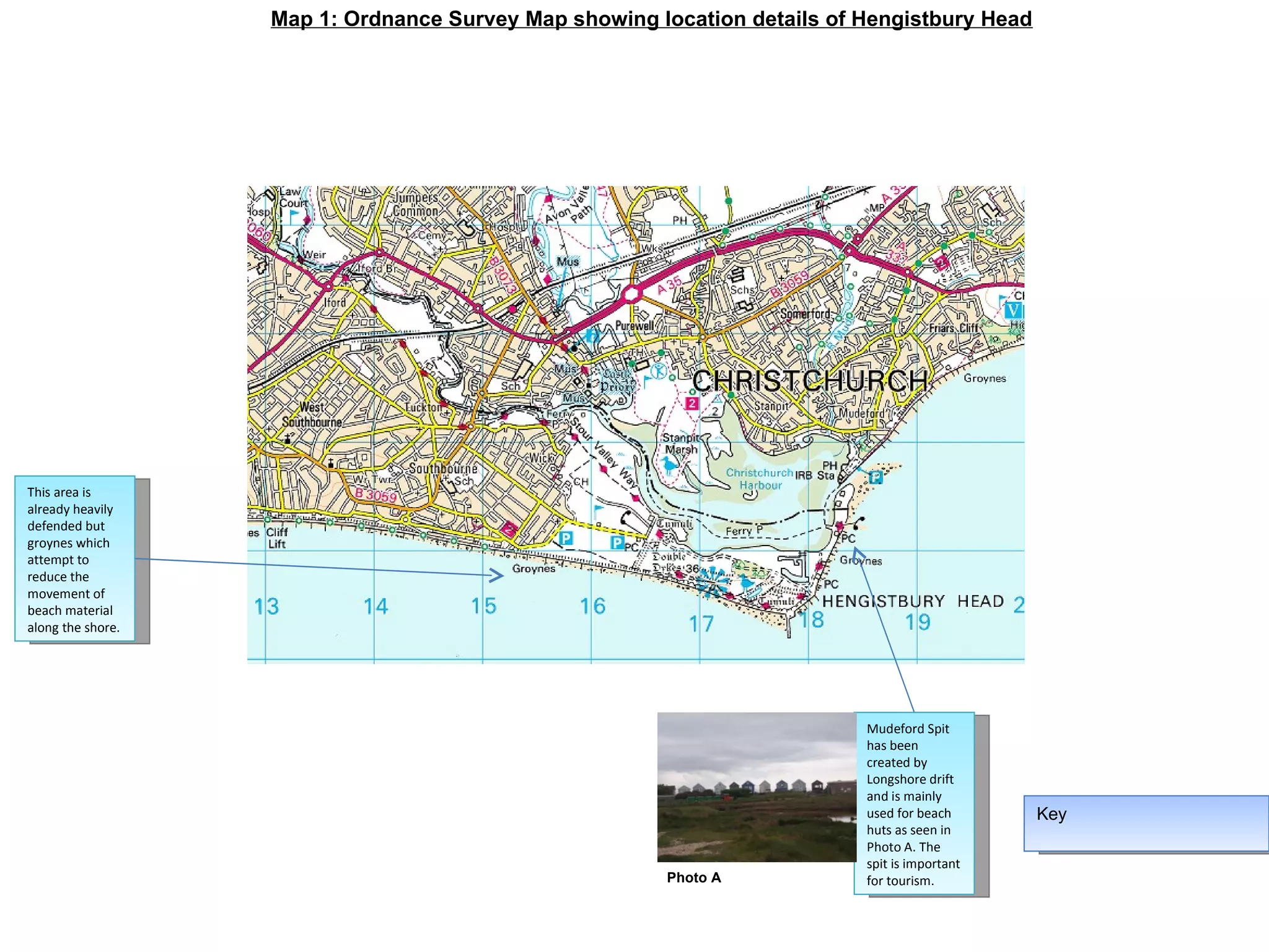
Here are the key points about coastal management schemes at Swanage:
1. Seawalls - To protect land and property from erosion and flooding by waves.
2. Groynes - To build up beaches by trapping sediment moving along the shore in longshore drift.
3. Beach replenishment - To replace sand lost through erosion and maintain the beach, protecting the land behind.
4. Managed realignment - To allow the shoreline to move landward naturally by breaching seawalls. This reduces costs and works with natural coastal processes.
5. Planting marram grass - To stabilise dunes and prevent/reduce blowouts. The roots bind sand particles.
Holderness good overview including detailWill Williams
Here are the key coastal management schemes at Swanage and their purposes:
1. Groynes - To trap sediment moving along the shore by longshore drift, building up the beach in front of the groynes.
2. Sea wall - To act as a hard barrier protecting the town from wave attack and sea level rise.
3. Beach replenishment - To replace sediment lost from the beach through coastal processes, maintaining a wide beach as protection.
4. Planting marram grass - To stabilise sand dunes and prevent/slow blowouts, protecting the hinterland from flooding and erosion.
5. Offshore breakwaters - To reduce wave energy reaching the shore by causing waves to break
The document discusses coastal erosion at Dunwich in Suffolk, England. It describes how Dunwich was once a thriving port town similar in size to London, but storms and erosion have destroyed most of it, leaving only a few cottages. The cliffs at Dunwich are made of soft sediments and experience erosion rates of up to 1 meter per year, mostly during storms. Longshore drift carries material south along the coast. In contrast, coastal management efforts like sea walls and beach replenishment have been used to protect the town of Aldeburgh further south from similar erosion.
This document provides information about an upcoming GCSE geography field trip to Westward Ho!, including:
- The main question is how and why coastal features vary in the Westward Ho! area.
- Key questions relate to coastal processes, landforms, engineering solutions and how the coastline may change over time.
- The fieldwork will study wave action, erosion, deposition and coastal management processes.
- Background research on coastal geography and the Westward Ho! area will help inform the fieldwork investigation.
L5 ap weather climate human activities on the coastandypinks
Human activities like urbanization, industry, and agriculture can change coastal landscapes in several ways:
1) Urbanization has led to the draining of wetlands for settlements, adding weight from development, and protecting cliffs from erosion, which can increase erosion elsewhere.
2) Industry has resulted in the growth of ports and facilities like oil refineries that have visual and environmental impacts.
3) Agriculture has involved draining wetlands and building ridges to protect low-lying farmland from the sea, though now some of these areas are no longer protected from coastal recession.
Realities of Beach Restoration in QuogueQuogueBeaches
Beach restoration using beach compatible sand from a suitable off-shore source is a logical extension of the existing Village Coastal Management Program that should be undertaken after issuance of the appropriate permits and consensus in the community.
A commercial pdf that includes some nice detail on 3 case studies of quarry restoration that give a breadth of post quarrying uses. Very useful for Geography GCSE rocks and landscape
The document summarizes a field trip taken by the Department of Geography at South Molton Community College to study coastal landforms in Westward Ho!, Devon. Key stops included Hartland Quay to examine the source of local pebbles, Westward Ho! beach to analyze wave patterns and erosion, and the Pebble Ridge to observe its retreat and attempts to reinforce it with structures like gabions and beach replenishment. The trip provided examples of coastal erosion, sediment transport, and management techniques to protect against flooding and ridge breaches.
The factors that have led to the Holderness coast suffering from erosion and the potential costs of this eroding coastline. Perfect for AS Level Geography.
The document outlines plans for a GCSE geography field trip to Lyme Regis to study coastal processes and management. Students will investigate why coastal protection is needed in the study area, looking at evidence of erosion, landforms, and existing hard and soft engineering defenses. They will consider how coastal risks may increase with projected sea level rise. The fieldwork relates to the OCR GCSE geography scheme of work focusing on coasts, hazards and human geography topics.
1) The coastal town of Hornsea suffers from erosion of weak boulder clay and loss of beach due to longshore sediment drift (LSD). This led to complaints and the construction of sea walls and groynes to build the beach back up as a defense.
2) The sea defenses at Hornsea have starved the nearby area of Mappleton of sand, causing its beaches to wash away from LSD. Two groynes and boulder revetments were constructed here for £2 million, reducing LSD and allowing more deposition.
3) Erosion at Great Cowden has been very rapid at 1-2 meters per year. Properties and farms are at risk from rotational slumping of saturated b
Coastal management integrated and sustainable managementMrOH
The Holderness Coast in northeast England is eroding rapidly due to its soft geology, large fetch exposure to North Sea storms, and coastal processes. Hard engineering can protect assets but is expensive and impacts the environment, while soft engineering uses natural defenses but requires maintenance. Coastal management plans take an integrated approach, using hard structures to hold the line in developed areas and managed retreat in others to allow creation of protective salt marshes. Sustainable approaches also use natural habitats but require abandoned land and may be unpopular.
There are several factors that determine whether a stretch of coastline is protected from erosion or not. Hard engineering approaches like groynes, sea walls, gabions, revetments, and rock armor are expensive options to prevent erosion but may not be aesthetically pleasing. Softer engineering techniques like beach nourishment, stabilizing sand dunes, and managed retreat are generally less expensive and more sustainable as they work with natural coastal processes. The Holderness Coast in England is an example of an eroding coastline where various hard and soft engineering strategies have been used to protect vulnerable areas from erosion over the past few centuries.
The document discusses coastal erosion issues facing several locations in the UK and Bangladesh. It examines the social, economic, political, and environmental impacts of cliff collapse and coastal flooding. These include loss of homes and land, damage to infrastructure, rising insurance costs, and loss of habitats. The document also outlines management strategies for some of the locations, such as building sea walls and replenishing eroded areas.
The document discusses coastal erosion issues in Happisburgh, England. It notes that over 250m of land was lost between 1600-1850, and 125m was lost between 1992-2007 at a rate of around 8m/year. The cliffs are comprised of glacial sands and clays that are easily eroded by the sea and saturated by rainwater. Coastal defenses could worsen the situation by disrupting sediment flows, while rising seas and stronger storms from climate change also increase erosion risks. The rapid erosion is negatively impacting the local community and environment through lost homes and infrastructure as well as valuable farmland.
This document discusses various landforms created by coastal erosion over thousands of years, including headlands and bays, cliffs and wave-cut platforms, and caves, arches, stacks, and stumps. It provides learning objectives to describe and explain the formation of these landforms through geological processes and the influence of vegetation. Diagrams and videos are referenced to illustrate each landform and the erosion process involved in its development.
The coastal landscape on the Isle of Purbeck in Dorset, England has been formed through the interaction of physical and human processes. The Isle of Purbeck is a peninsula located in southern England surrounded by the English Channel. The geology of Wealden clay and the prevailing southwesterly winds have contributed to coastal erosion through rotational landslides. Human activity such as tourism, settlement, and the construction of coastal defences and groynes have also impacted the landscape around Swanage Bay over time.
This document provides a recap and consolidation of fieldwork conducted in Devon. It outlines the objectives to consolidate all work done in Devon and ensure students have all notes in their folders. It discusses the fieldwork and research conducted in Torquay and Start Bay, including questionnaires, land use surveys, beach profiles, and cost-benefit analyses conducted, as well as potential research sources like old maps, photos, census data, and news articles. Today's lesson will have students draw up research tables on the changes in Torquay's land use and development as a coastal resort, and the evaluation of coastal defenses and management at Start Bay.
The Holderness Coastline of England suffers from the highest rates of coastal erosion in Europe due to its soft, easily eroded geology and exposure to strong winds and waves from the North Sea. Several villages have been lost to coastal erosion over the centuries. While some areas implement hard coastal defenses like seawalls and rock armor to combat erosion, these strategies are costly to maintain and can worsen erosion elsewhere down the coast. Integrated coastal zone management is now sought to balance protection of infrastructure with the natural shoreline processes.
This document discusses the different processes that shape coastal landscapes. It aims to teach students that coastal landscapes are changed by various processes and how these processes can alter the coast. It identifies marine or coastal processes like wave erosion, transport, and deposition as well as land-based processes like weathering and mass movement. Students are then instructed to work in groups to create presentations explaining how their assigned process shapes the coastal landscape.
The urban wetland protection against rising sea levels in skanör falsterboRebecka Ingemansson
The document describes a site located near Falsterbo canal in Sweden that is being considered for public development. It is close to the communities of Ljunghusen and Höllviken. There is also a school and daycare nearby making it suitable for recreational and educational activities. The site is threatened by rising sea levels predicted to increase by 1 meter in the next 100 years. The proposed design creates a protective dyke and floating wetland to mitigate flooding and storm damage, while keeping the area accessible via an elevated boardwalk. This helps embrace the wetland and grow the surrounding communities in a sustainable way.
The document discusses research and fieldwork on erosion and flooding along coastal areas. It outlines:
1) Upcoming fieldwork in Start Bay, Devon to study coastal erosion, including land use mapping, observations of rock falls and undercutting.
2) Additional fieldwork on flooding would include interviewing local residents about past flood events and mapping coastal flood risk areas.
3) Recommendations for online research on either erosion or flooding using tools like historical maps, Google Earth, newspaper archives and census records to study how coastlines have changed over time.
The document summarizes the effects of Bainbridge Island's Shoreline Master Program on the environment based on Hydraulic Project Approvals from 1997-2010. It finds:
1) A net reduction in hard shoreline armoring and overwater structures, replacement of creosote treated wood, and removal of creosote treated pilings.
2) Deposition of sand and gravel to nourish beaches, planting of native vegetation, and restoration of tidelands and eelgrass beds.
3) That while "no net loss" was not the standard in 1996, existing policies are producing gains and a net increase in ecological function overall on the island.
This document summarizes a survey of a 250m stretch of highway in Shrine Hills, Davao City. It finds that the sediment layers in the area are unstable and prone to landslides, especially during heavy rain or earthquakes. Recent events like rock falls and landslides have already damaged properties and infrastructure. The conclusion recommends preserving Shrine Hills as a protected area given its environmental and economic benefits, and locating future development outside of hazard-prone areas.
The document provides an overview of the forces shaping Long Island's dynamic south shore coastline. It discusses how the coastline is composed of different shoreline types, including barrier islands in the west and glacial bluffs in the east. It also changes from heavily developed in the west to summer resort communities in the east. The shoreline is constantly changing in response to natural processes like waves, storms, sea level rise and sediment transport, as well as human activities. Storms particularly impact the shoreline, causing beach erosion and shifting of the shoreline position in response to storm waves and surges. Over the long term, sea level rise and barrier island migration also influence shoreline changes.
This document provides information about coastal landforms and erosion along the Jurassic Coast in Dorset, England. It discusses how the underlying geology influences erosion rates and the formation of different landforms. Key points covered include:
- The Jurassic Coast exposes geology spanning millions of years, including rocks from the Jurassic period 200-140 million years ago.
- More resistant rock types like chalk erode more slowly than less resistant rocks like clay and limestone, leading to the formation of bays in softer rocks and headlands in harder rocks.
- Lulworth Cove is used as a case study, having formed from differential erosion of tilted rock layers, with the cove eroding inland until reaching
Getting to grips with enquiry 2018 slideshareDavid Rogers
Slide to support a session that explored the application of Geographical Enquiry to the classroom and sequences of lessons. Given to University of Portsmouth Geography ITT students on 12th October 2018.
Staff room notices - helping to establish an evidence informed cultureDavid Rogers
The document discusses education at universities and how it traditionally worked by bringing together young people and books with the hope that knowledge would pass between them, similar to how young people would gather at inns and taverns to socialize. It notes the similarity in the approaches despite different intentions, with education relying on proximity and socialization to facilitate learning rather than direct instruction.
1. Teachers need a curriculum and schemes of work to guide their lessons and ensure coverage of essential content.
2. Effective teaching strategies include using starters, testing, and retrieval practice to reinforce learning. Teachers should also incorporate extended writing assignments and focus on teaching challenging concepts rather than superficial "pants" work.
3. To achieve excellence, teachers must consider the holistic development of students and ensure their lessons, contacts, experiences and self-image support full growth beyond just academic achievement. Regularly revisiting foundational knowledge is also important.
This document contains a collection of personal anecdotes and accomplishments that demonstrate perseverance in achieving long term goals despite challenges or setbacks. Examples include completing a doctorate through 6 years of part-time study, learning to swim after decades of lessons, running ultra marathons after being told one couldn't, and helping a student reduce anxiety over 3 years. Also mentioned is keeping a beard as a reminder to follow one's dreams.
This document discusses priorities for change and managing that change effectively. It emphasizes identifying the main priority or "main thing", creating a vision and plan to address it, and monitoring impact over time. Key aspects of managing change include understanding the current situation, desired future state, steps to close the gap, and metrics to track progress. Sharing ideas and gaining input from others is also highlighted. The overall message is the importance of keeping the primary focus clear and strategically managing initiatives for progress.
Students were divided into four groups based on their grit scores from the Duckworth grit test: gritty and exceeding expectations, gritty and below expectations, not gritty and exceeding expectations, not gritty and below expectations. Various data about the groups such as their academic progress, attendance, proportion receiving pupil premium funding (likely low-income), and gender proportions is shown in charts. The document examines differences between these grit groups.
Is there a link between extra curricular clubs and attendanceDavid Rogers
This study examines strategies to reduce absenteeism among disadvantaged ("Pupil Premium") students. The researchers hypothesize that an intervention involving weekly meetings between students and administrators, and participation in extracurricular activities, will increase students' connection to school and improve attendance. Preliminary findings show positive correlations between extracurricular participation and higher perceived teacher support, school attendance, and student happiness. The full study will analyze these relationships further and compare the results to existing literature on improving school engagement and outcomes for at-risk youth.
Rapid urbanization can lead to overcrowding, strain on services like schools, unplanned building development, lack of sanitation and clean drinking water, and lack of tax revenue to fund services. Urbanized basins with steep valleys, deforestation, large catchment areas, and saturated soils are more likely to experience flashy hydrographs during rainfall events. Methods to manage flooding include hard engineering solutions like dams, flood walls, and embankments as well as softer strategies like afforestation and flood plain zoning. Coastal erosion can be addressed through hard structures like sea walls and groynes or softer approaches such as managed retreat and beach replenishment.
Lesson exploring Rio's favelas. With thanks to Noel Jenkins for the place description as seen on his blog: http://www.digitalgeography.co.uk/archives/2012/11/describing-place/
The document provides details on 12 case studies related to geography revision. Case Study 5 examines a proposed planned development of 10,000 new homes in Mid Sussex, UK. The private developers aim to meet housing demand while reducing pressure on small villages and larger towns. Advantages include easing housing pressure, limiting urban sprawl, providing infrastructure in one development rather than many additions, and boosting local jobs and services. However, the development would replace low-grade farmland and impact the sparse local population.
Making connections between primary and secondary classroomsDavid Rogers
Slides to support a workshop delivered at the Geographical Association's Conference in April 2016. Exploring the links between primary and secondary classrooms
The document contains lyrics from several songs interspersed with short phrases or sentences. It discusses themes of perseverance, never giving up, keeping one's integrity and individuality, and finding freedom and purpose through believing in oneself.
Teacher Standard 5 - Adapting teaching for all learnersDavid Rogers
This document contains a series of posts by David E Rogers on adapting teaching to meet student needs. It discusses assessing students, supporting literacy and numeracy, engaging students through place-based learning, using images and questions to spark curiosity, and the importance of feedback. It also addresses challenges in adapting schemes of work and how to promote a love of learning geography through fieldwork, current events and using multiple senses.
Slide to accompany a talk around how fieldwork should be approached in response to the 2016 GCSE Geography changes. Given as part of the Geographical Association's New Geography GCSE courses.
This document discusses how every decision you make shapes who you become in the future. It advises the reader to look at who they want to be and start taking actions that sculpt themselves into that person, even if they don't end up exactly where they planned. The key message is for the reader not to just drift through life and randomly become an adult they don't want to be, but to actively work on becoming the person they envision.
Mark scheme for the geographical enquiryDavid Rogers
This document outlines a mark scheme for assessing a geographical enquiry. It provides descriptors for assessing students' knowledge and understanding, application, and skills. For knowledge and understanding, it evaluates the details students recall about their hypothesis, the terms they use, their understanding, and the conclusions they draw. For application, it assesses how students apply their knowledge to geographical ideas, concepts and theories. For skills, it evaluates the techniques students use to collect, present, and analyze data, how they evaluate their methods and data, and their communication skills. It also provides notes advising students that they do not need to write a methodology, and giving strategies for students to access marks related to applying their wider geographical understanding. Finally, it outlines some
Main Java[All of the Base Concepts}.docxadhitya5119
This is part 1 of my Java Learning Journey. This Contains Custom methods, classes, constructors, packages, multithreading , try- catch block, finally block and more.
A review of the growth of the Israel Genealogy Research Association Database Collection for the last 12 months. Our collection is now passed the 3 million mark and still growing. See which archives have contributed the most. See the different types of records we have, and which years have had records added. You can also see what we have for the future.
How to Build a Module in Odoo 17 Using the Scaffold MethodCeline George
Odoo provides an option for creating a module by using a single line command. By using this command the user can make a whole structure of a module. It is very easy for a beginner to make a module. There is no need to make each file manually. This slide will show how to create a module using the scaffold method.
Executive Directors Chat Leveraging AI for Diversity, Equity, and InclusionTechSoup
Let’s explore the intersection of technology and equity in the final session of our DEI series. Discover how AI tools, like ChatGPT, can be used to support and enhance your nonprofit's DEI initiatives. Participants will gain insights into practical AI applications and get tips for leveraging technology to advance their DEI goals.
বাংলাদেশের অর্থনৈতিক সমীক্ষা ২০২৪ [Bangladesh Economic Review 2024 Bangla.pdf] কম্পিউটার , ট্যাব ও স্মার্ট ফোন ভার্সন সহ সম্পূর্ণ বাংলা ই-বুক বা pdf বই " সুচিপত্র ...বুকমার্ক মেনু 🔖 ও হাইপার লিংক মেনু 📝👆 যুক্ত ..
আমাদের সবার জন্য খুব খুব গুরুত্বপূর্ণ একটি বই ..বিসিএস, ব্যাংক, ইউনিভার্সিটি ভর্তি ও যে কোন প্রতিযোগিতা মূলক পরীক্ষার জন্য এর খুব ইম্পরট্যান্ট একটি বিষয় ...তাছাড়া বাংলাদেশের সাম্প্রতিক যে কোন ডাটা বা তথ্য এই বইতে পাবেন ...
তাই একজন নাগরিক হিসাবে এই তথ্য গুলো আপনার জানা প্রয়োজন ...।
বিসিএস ও ব্যাংক এর লিখিত পরীক্ষা ...+এছাড়া মাধ্যমিক ও উচ্চমাধ্যমিকের স্টুডেন্টদের জন্য অনেক কাজে আসবে ...
RPMS TEMPLATE FOR SCHOOL YEAR 2023-2024 FOR TEACHER 1 TO TEACHER 3
Example of an annotated map
1. Map 1: Ordnance Survey Map showing location details of Hengistbury Head Key This area is already heavily defended but groynes which attempt to reduce the movement of beach material along the shore. Mudeford Spit has been created by Longshore drift and is mainly used for beach huts as seen in Photo A. The spit is important for tourism. Photo A