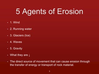
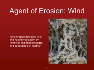
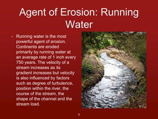
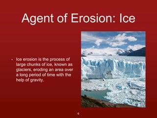
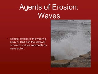
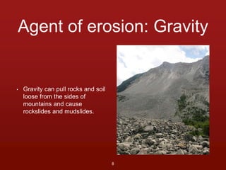
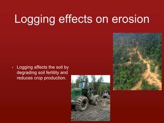
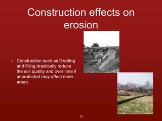
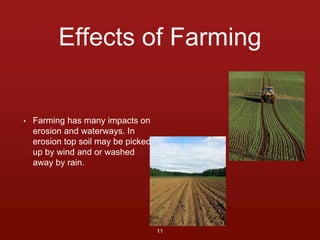
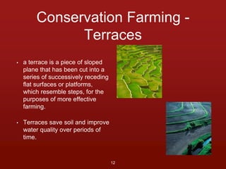
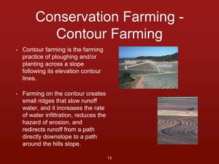
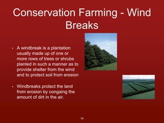
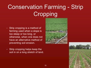
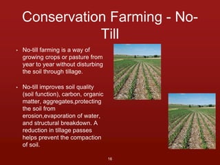
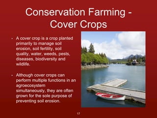
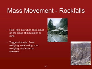
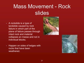
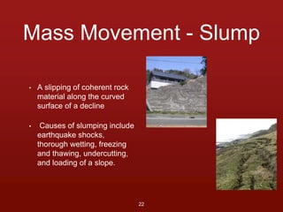
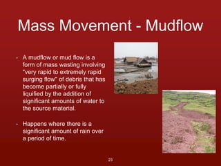
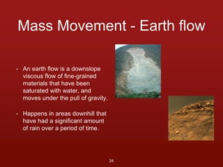
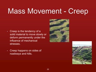
Erosion 
By Jared Mellody 
1 
In association with 
2nd Hour Earth Science
Definition 
• The process of eroding or 
being eroded by wind, water, 
or other natural agents. 
2
5 Agents of Erosion 
• 1. Wind 
• 2. Running water 
• 3. Glaciers (Ice) 
• 4. Waves 
• 5. Gravity 
• What they are ↓ 
• The direct source of movement that can cause erosion through 
the transfer of energy or transport of rock material. 
3
Agent of Erosion: Wind 
• Wind erosion damages land 
and natural vegetation by 
removing soil from one place 
and depositing it in another. 
4
Agent of Erosion: Running 
Water 
• Running water is the most 
powerful agent of erosion. 
Continents are eroded 
primarily by running water at 
an average rate of 1 inch every 
750 years. The velocity of a 
stream increases as its 
gradient increases but velocity 
is also influenced by factors 
such as degree of turbulence, 
position within the river, the 
course of the stream, the 
shape of the channel and the 
stream load. 
5
Agent of Erosion: Ice 
• Ice erosion is the process of 
large chunks of ice, known as 
glaciers, eroding an area over 
a long period of time with the 
help of gravity. 
6
Agents of Erosion: 
Waves 
• Coastal erosion is the wearing 
away of land and the removal 
of beach or dune sediments by 
wave action. 
7
Agent of erosion: Gravity 
• Gravity can pull rocks and soil 
loose from the sides of 
mountains and cause 
rockslides and mudslides. 
8
Logging effects on erosion 
• Logging affects the soil by 
degrading soil fertility and 
reduces crop production. 
9
Construction effects on 
erosion 
• Construction such as Grading 
and filling drastically reduce 
the soil quality and over time if 
unprotected may affect more 
areas. 
10
Effects of Farming 
• Farming has many impacts on 
erosion and waterways. In 
erosion top soil may be picked 
up by wind and or washed 
away by rain. 
11
Conservation Farming - 
Terraces 
• a terrace is a piece of sloped 
plane that has been cut into a 
series of successively receding 
flat surfaces or platforms, 
which resemble steps, for the 
purposes of more effective 
farming. 
• Terraces save soil and improve 
water quality over periods of 
time. 
12
Conservation Farming - 
Contour Farming 
• Contour farming is the farming 
practice of ploughing and/or 
planting across a slope 
following its elevation contour 
lines. 
• Farming on the contour creates 
small ridges that slow runoff 
water, and it increases the rate 
of water infiltration, reduces the 
hazard of erosion, and 
redirects runoff from a path 
directly downslope to a path 
around the hills slope. 
13
Conservation Farming - Wind 
Breaks 
• A windbreak is a plantation 
usually made up of one or 
more rows of trees or shrubs 
planted in such a manner as to 
provide shelter from the wind 
and to protect soil from erosion 
• Windbreaks protect the land 
from erosion by congaing the 
amount of dirt in the air. 
14
Conservation Farming - Strip 
Cropping 
• Strip cropping is a method of 
farming used when a slope is 
too steep or too long, or 
otherwise, when one does not 
have an alternative method of 
preventing soil erosion. 
• Strip cropping helps keep the 
soil in on a long stretch of land. 
15
Conservation Farming - No- 
Till 
• No-till farming is a way of 
growing crops or pasture from 
year to year without disturbing 
the soil through tillage. 
• No-till improves soil quality 
(soil function), carbon, organic 
matter, aggregates,protecting 
the soil from 
erosion,evaporation of water, 
and structural breakdown. A 
reduction in tillage passes 
helps prevent the compaction 
of soil. 
16
Conservation Farming - 
Cover Crops 
• A cover crop is a crop planted 
primarily to manage soil 
erosion, soil fertility, soil 
quality, water, weeds, pests, 
diseases, biodiversity and 
wildlife. 
• Although cover crops can 
perform multiple functions in an 
agroecosystem 
simultaneously, they are often 
grown for the sole purpose of 
preventing soil erosion. 
17
Mass Movement 
• Mass movement is the movement of surface 
material caused by gravity. 
18
4 triggers of Mass Movement 
• Creeps 
• The combination of small 
movements of soil or rock in 
different directions over time 
are directed by gravity 
gradually downslope 
• Landslides 
• A landslide, also called a 
landslip, is a rapid movement 
of a large mass of earth and 
rocks down a hill or a 
mountainside 
• Slump 
• A slipping of coherent rock 
material along the curved 
surface of a decline 
• Falls 
• It is where regolith cascades 
down a slope, but is not of 
sufficient volume or viscosity 
to behave as a flow. 
19
Mass Movement - Rockfalls 
• Rock falls are when rock slides 
off the sides of mountains or 
cliffs. 
• Triggers include: Frost 
wedging, weathering, root 
wedging, and external 
stresses. 
20
Mass Movement - Rock 
slides 
• A rockslide is a type of 
landslide caused by rock 
failure in which part of the 
plane of failure passes through 
intact rock and material 
collapses en masse and not in 
individual blocks. 
• Happen on sides of ledges with 
rocks that have been 
weathered. 
21
Mass Movement - Slump 
• A slipping of coherent rock 
material along the curved 
surface of a decline 
• Causes of slumping include 
earthquake shocks, 
thorough wetting, freezing 
and thawing, undercutting, 
and loading of a slope. 
22
Mass Movement - Mudflow 
• A mudflow or mud flow is a 
form of mass wasting involving 
"very rapid to extremely rapid 
surging flow" of debris that has 
become partially or fully 
liquified by the addition of 
significant amounts of water to 
the source material. 
• Happens where there is a 
significant amount of rain over 
a period of time. 
23
Mass Movement - Earth flow 
• An earth flow is a downslope 
viscous flow of fine-grained 
materials that have been 
saturated with water, and 
moves under the pull of gravity. 
• Happens in areas downhill that 
have had a significant amount 
of rain over a period of time. 
24
Mass Movement - Creep 
• Creep is the tendency of a 
solid material to move slowly or 
deform permanently under the 
influence of mechanical 
stresses. 
• Creep happens on sides of 
roadways and hills. 
25
Citations (in order by slide) 
• https://www.flickr.com/photos/bertknot/9502855842/ 
• http://commons.wikimedia.org/wiki/File:Rhizolith_group_revealed_after_wind_erosion_3.JPG 
• http://commons.wikimedia.org/wiki/File:Urban_stream_in_park.jpg 
• http://en.wikipedia.org/wiki/Glacier#mediaviewer/File:Perito_Moreno_Glacier_Patagonia_Argentina_Luca_Galuzzi_2005.JPG 
• http://www.geograph.org.uk/photo/3841186 
• http://en.wikipedia.org/wiki/Frank_Slide#mediaviewer/File:Frank_Slide,_Canada.jpg 
• http://upload.wikimedia.org/wikipedia/commons/a/ab/Logging_road_East_Kalimantan_2005.jpg 
• http://s0.geograph.org.uk/geophotos/02/57/62/2576240_25bae00c.jpg 
• http://upload.wikimedia.org/wikipedia/commons/4/4f/Chickamauga_Dam_(1936)_-_Dam_construction_erosion_control.jpg 
• http://upload.wikimedia.org/wikipedia/commons/9/9a/Silt_fence_EPA.jpg 
• http://s0.geograph.org.uk/geophotos/01/56/59/1565950_b4bc2411.jpg 
• http://pixabay.com/static/uploads/photo/2013/07/19/00/18/food-165214_640.jpg 
• http://upload.wikimedia.org/wikipedia/commons/d/df/Batad_Rice_Terraces.jpg 
• http://upload.wikimedia.org/wikipedia/commons/thumb/c/c4/TerracesBuffers.JPG/640px-TerracesBuffers.JPG 
26
Citations Cont. (in order by slide) 
• http://watershedbmps.com/wp-content/uploads/2012/09/ContourFarming_plantandsoil_unl_edu.jpg 
• http://cottontoday.cottoninc.com/natural-resources/soil/images/organic.jpg 
• http://www.mda.state.mn.us/protecting/conservation/practices/~/media/Images/protecting/practices/fieldwindbreak1. 
ashx?w=300&h=214&as=1 
• http://www.mda.state.mn.us/protecting/conservation/practices/~/media/Images/protecting/practices/fieldwindbreak2. 
ashx?w=300&h=214&as=1 
• http://upload.wikimedia.org/wikipedia/commons/0/0b/Cotton_Production_in_the_North_Carolina_Coastal_Plain.jpg 
• https://c2.staticflickr.com/6/5075/5878650615_bc834fa040_b.jpg 
• https://c1.staticflickr.com/9/8032/8053619620_11c351fd20_b.jpg 
• http://upload.wikimedia.org/wikipedia/commons/e/ea/Rockfall.jpg 
• http://www.landforms.eu/shetland/images/villians_ure.JPG 
• http://upload.wikimedia.org/wikipedia/commons/thumb/1/15/Rockslide_at_Oddicombe.jpg/800px- 
Rockslide_at_Oddicombe.jpg 
• http://upload.wikimedia.org/wikipedia/commons/4/42/Rock_slide.jpg 
27
Citations Cont.[#2] (in order by slide) 
• http://upload.wikimedia.org/wikipedia/commons/c/cb/Misaki_Stratum_Slump_Structur 
e_2013-03.JPG 
• http://s0.geograph.org.uk/geophotos/02/27/31/2273175_d8bb4209.jpg 
• http://upload.wikimedia.org/wikipedia/commons/6/63/Slide-guerrero1.JPG 
• http://t3.gstatic.com/images?q=tbn:ANd9GcTWxhOEtzWKMP1Hkk-whSSzsxilpkJzZK9OqPgodT_ 
MQkSZAREfJg 
• http://upload.wikimedia.org/wikipedia/commons/thumb/e/e6/Home_sunk_by_mud_flo 
w.JPG/1024px-Home_sunk_by_mud_flow.JPG 
• http://s0.geograph.org.uk/geophotos/01/40/58/1405853_fa82c7e8.jpg 
• http://upload.wikimedia.org/wikipedia/commons/0/0e/Soil_Creep,_Millennium_Hill_- 
_geograph.org.uk_-_518574.jpg 
• http://s0.geograph.org.uk/geophotos/02/09/15/2091548_7454d853.jpg 
28

Erosion by Bluejays77

  • 1.
    Erosion By JaredMellody 1 In association with 2nd Hour Earth Science
  • 2.
    Definition • Theprocess of eroding or being eroded by wind, water, or other natural agents. 2
  • 3.
    5 Agents ofErosion • 1. Wind • 2. Running water • 3. Glaciers (Ice) • 4. Waves • 5. Gravity • What they are ↓ • The direct source of movement that can cause erosion through the transfer of energy or transport of rock material. 3
  • 4.
    Agent of Erosion:Wind • Wind erosion damages land and natural vegetation by removing soil from one place and depositing it in another. 4
  • 5.
    Agent of Erosion:Running Water • Running water is the most powerful agent of erosion. Continents are eroded primarily by running water at an average rate of 1 inch every 750 years. The velocity of a stream increases as its gradient increases but velocity is also influenced by factors such as degree of turbulence, position within the river, the course of the stream, the shape of the channel and the stream load. 5
  • 6.
    Agent of Erosion:Ice • Ice erosion is the process of large chunks of ice, known as glaciers, eroding an area over a long period of time with the help of gravity. 6
  • 7.
    Agents of Erosion: Waves • Coastal erosion is the wearing away of land and the removal of beach or dune sediments by wave action. 7
  • 8.
    Agent of erosion:Gravity • Gravity can pull rocks and soil loose from the sides of mountains and cause rockslides and mudslides. 8
  • 9.
    Logging effects onerosion • Logging affects the soil by degrading soil fertility and reduces crop production. 9
  • 10.
    Construction effects on erosion • Construction such as Grading and filling drastically reduce the soil quality and over time if unprotected may affect more areas. 10
  • 11.
    Effects of Farming • Farming has many impacts on erosion and waterways. In erosion top soil may be picked up by wind and or washed away by rain. 11
  • 12.
    Conservation Farming - Terraces • a terrace is a piece of sloped plane that has been cut into a series of successively receding flat surfaces or platforms, which resemble steps, for the purposes of more effective farming. • Terraces save soil and improve water quality over periods of time. 12
  • 13.
    Conservation Farming - Contour Farming • Contour farming is the farming practice of ploughing and/or planting across a slope following its elevation contour lines. • Farming on the contour creates small ridges that slow runoff water, and it increases the rate of water infiltration, reduces the hazard of erosion, and redirects runoff from a path directly downslope to a path around the hills slope. 13
  • 14.
    Conservation Farming -Wind Breaks • A windbreak is a plantation usually made up of one or more rows of trees or shrubs planted in such a manner as to provide shelter from the wind and to protect soil from erosion • Windbreaks protect the land from erosion by congaing the amount of dirt in the air. 14
  • 15.
    Conservation Farming -Strip Cropping • Strip cropping is a method of farming used when a slope is too steep or too long, or otherwise, when one does not have an alternative method of preventing soil erosion. • Strip cropping helps keep the soil in on a long stretch of land. 15
  • 16.
    Conservation Farming -No- Till • No-till farming is a way of growing crops or pasture from year to year without disturbing the soil through tillage. • No-till improves soil quality (soil function), carbon, organic matter, aggregates,protecting the soil from erosion,evaporation of water, and structural breakdown. A reduction in tillage passes helps prevent the compaction of soil. 16
  • 17.
    Conservation Farming - Cover Crops • A cover crop is a crop planted primarily to manage soil erosion, soil fertility, soil quality, water, weeds, pests, diseases, biodiversity and wildlife. • Although cover crops can perform multiple functions in an agroecosystem simultaneously, they are often grown for the sole purpose of preventing soil erosion. 17
  • 18.
    Mass Movement •Mass movement is the movement of surface material caused by gravity. 18
  • 19.
    4 triggers ofMass Movement • Creeps • The combination of small movements of soil or rock in different directions over time are directed by gravity gradually downslope • Landslides • A landslide, also called a landslip, is a rapid movement of a large mass of earth and rocks down a hill or a mountainside • Slump • A slipping of coherent rock material along the curved surface of a decline • Falls • It is where regolith cascades down a slope, but is not of sufficient volume or viscosity to behave as a flow. 19
  • 20.
    Mass Movement -Rockfalls • Rock falls are when rock slides off the sides of mountains or cliffs. • Triggers include: Frost wedging, weathering, root wedging, and external stresses. 20
  • 21.
    Mass Movement -Rock slides • A rockslide is a type of landslide caused by rock failure in which part of the plane of failure passes through intact rock and material collapses en masse and not in individual blocks. • Happen on sides of ledges with rocks that have been weathered. 21
  • 22.
    Mass Movement -Slump • A slipping of coherent rock material along the curved surface of a decline • Causes of slumping include earthquake shocks, thorough wetting, freezing and thawing, undercutting, and loading of a slope. 22
  • 23.
    Mass Movement -Mudflow • A mudflow or mud flow is a form of mass wasting involving "very rapid to extremely rapid surging flow" of debris that has become partially or fully liquified by the addition of significant amounts of water to the source material. • Happens where there is a significant amount of rain over a period of time. 23
  • 24.
    Mass Movement -Earth flow • An earth flow is a downslope viscous flow of fine-grained materials that have been saturated with water, and moves under the pull of gravity. • Happens in areas downhill that have had a significant amount of rain over a period of time. 24
  • 25.
    Mass Movement -Creep • Creep is the tendency of a solid material to move slowly or deform permanently under the influence of mechanical stresses. • Creep happens on sides of roadways and hills. 25
  • 26.
    Citations (in orderby slide) • https://www.flickr.com/photos/bertknot/9502855842/ • http://commons.wikimedia.org/wiki/File:Rhizolith_group_revealed_after_wind_erosion_3.JPG • http://commons.wikimedia.org/wiki/File:Urban_stream_in_park.jpg • http://en.wikipedia.org/wiki/Glacier#mediaviewer/File:Perito_Moreno_Glacier_Patagonia_Argentina_Luca_Galuzzi_2005.JPG • http://www.geograph.org.uk/photo/3841186 • http://en.wikipedia.org/wiki/Frank_Slide#mediaviewer/File:Frank_Slide,_Canada.jpg • http://upload.wikimedia.org/wikipedia/commons/a/ab/Logging_road_East_Kalimantan_2005.jpg • http://s0.geograph.org.uk/geophotos/02/57/62/2576240_25bae00c.jpg • http://upload.wikimedia.org/wikipedia/commons/4/4f/Chickamauga_Dam_(1936)_-_Dam_construction_erosion_control.jpg • http://upload.wikimedia.org/wikipedia/commons/9/9a/Silt_fence_EPA.jpg • http://s0.geograph.org.uk/geophotos/01/56/59/1565950_b4bc2411.jpg • http://pixabay.com/static/uploads/photo/2013/07/19/00/18/food-165214_640.jpg • http://upload.wikimedia.org/wikipedia/commons/d/df/Batad_Rice_Terraces.jpg • http://upload.wikimedia.org/wikipedia/commons/thumb/c/c4/TerracesBuffers.JPG/640px-TerracesBuffers.JPG 26
  • 27.
    Citations Cont. (inorder by slide) • http://watershedbmps.com/wp-content/uploads/2012/09/ContourFarming_plantandsoil_unl_edu.jpg • http://cottontoday.cottoninc.com/natural-resources/soil/images/organic.jpg • http://www.mda.state.mn.us/protecting/conservation/practices/~/media/Images/protecting/practices/fieldwindbreak1. ashx?w=300&h=214&as=1 • http://www.mda.state.mn.us/protecting/conservation/practices/~/media/Images/protecting/practices/fieldwindbreak2. ashx?w=300&h=214&as=1 • http://upload.wikimedia.org/wikipedia/commons/0/0b/Cotton_Production_in_the_North_Carolina_Coastal_Plain.jpg • https://c2.staticflickr.com/6/5075/5878650615_bc834fa040_b.jpg • https://c1.staticflickr.com/9/8032/8053619620_11c351fd20_b.jpg • http://upload.wikimedia.org/wikipedia/commons/e/ea/Rockfall.jpg • http://www.landforms.eu/shetland/images/villians_ure.JPG • http://upload.wikimedia.org/wikipedia/commons/thumb/1/15/Rockslide_at_Oddicombe.jpg/800px- Rockslide_at_Oddicombe.jpg • http://upload.wikimedia.org/wikipedia/commons/4/42/Rock_slide.jpg 27
  • 28.
    Citations Cont.[#2] (inorder by slide) • http://upload.wikimedia.org/wikipedia/commons/c/cb/Misaki_Stratum_Slump_Structur e_2013-03.JPG • http://s0.geograph.org.uk/geophotos/02/27/31/2273175_d8bb4209.jpg • http://upload.wikimedia.org/wikipedia/commons/6/63/Slide-guerrero1.JPG • http://t3.gstatic.com/images?q=tbn:ANd9GcTWxhOEtzWKMP1Hkk-whSSzsxilpkJzZK9OqPgodT_ MQkSZAREfJg • http://upload.wikimedia.org/wikipedia/commons/thumb/e/e6/Home_sunk_by_mud_flo w.JPG/1024px-Home_sunk_by_mud_flow.JPG • http://s0.geograph.org.uk/geophotos/01/40/58/1405853_fa82c7e8.jpg • http://upload.wikimedia.org/wikipedia/commons/0/0e/Soil_Creep,_Millennium_Hill_- _geograph.org.uk_-_518574.jpg • http://s0.geograph.org.uk/geophotos/02/09/15/2091548_7454d853.jpg 28