Thank you for the scenario. Let me know if you need any assistance from CERT trained staff. Our priority is caring for the injured until emergency responders arrive.
Last Year
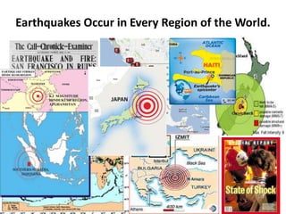
The UnitedStates witnessed it’s Share…
• Super Tornado Outbreak April 25-28, 2011
• Mississippi River Floods April and May 2011
• Joplin, Missouri EF-5 Tornado May 22, 2011
• Texas, New Mexico & Arizona Wildfires 2011
• Virginia 5.8 Earthquake August 23, 2011
• Hurricane Irene August 24-30, 2011
4.
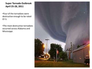
Super Tornado Outbreak
April 25-28, 2011
•Four of the tornadoes were
destructive enough to be rated
EF-5.
•The most destructive tornadoes
occurred across Alabama and
Mississippi.
5.
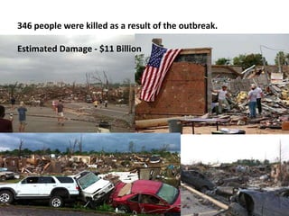
346 people werekilled as a result of the outbreak.
Estimated Damage - $11 Billion
6.
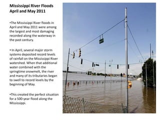
Mississippi River Floods
Apriland May 2011
•The Mississippi River floods in
April and May 2011 were among
the largest and most damaging
recorded along the waterway in
the past century.
• In April, several major storm
systems deposited record levels
of rainfall on the Mississippi River
watershed. When that additional
water combined with the
springtime snowmelt, the river
and many of its tributaries began
to swell to record levels by the
beginning of May.
•This created the perfect situation
for a 500-year flood along the
Mississippi.
7.
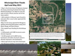
Mississippi River Floods
April and May 2011
• May 3, the Army Corps of Engineers blasted
the levee protecting the Birds Point-New
Madrid Floodway in an effort to save the
town of Cairo, Illinois and the rest of the
levee system.
• 200 residents in Missouri were forced to
evacuate after a court order approved the
Corps plan.
•May 14, the Corps opened the Morganza
Spillway diverting flood waters away from
Baton Rouge and New Orleans.
•The tradeoff was flooding the Atchafalaya
Basin.
• 2,500 people and 2,000 structures were
directly impacted.
• 22,500 people and 11,000 homes,
businesses and other structures were in-
directly impacted in the backwaters.
• Many agricultural crops were destroyed.
•The Morganza Spillway remained open until
July 7.
8.
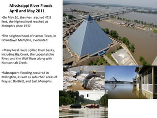
Mississippi River Floods
April and May 2011
•On May 10, the river reached 47.8
feet, the highest level reached at
Memphis since 1937.
•The neighborhood of Harbor Town, in
Downtown Memphis, evacuated.
• Many local rivers spilled their banks,
including Big Creek, the Loosahatchie
River, and the Wolf River along with
Nonconnah Creek.
•Subsequent flooding occurred in
Millington, as well as suburban areas of
Frayser, Bartlett, and East Memphis.
9.
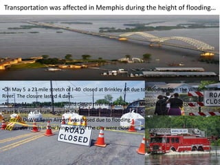
Transportation was affectedin Memphis during the height of flooding…
•On May 5 a 23 mile stretch of I-40 closed at Brinkley AR due to flooding from the White
River. The closure lasted 4 days.
•Also on May 5th the Coast Guard closed river traffic North of Memphis for safety concerns.
•East & West rail traffic over the Mississippi was halted.
•General DeWitt Spain Airport was closed due to flooding.
•Numerous roads in low lying areas of the city were closed.
10.
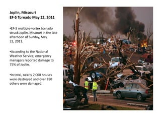
Joplin, Missouri
EF-5 TornadoMay 22, 2011
•EF-5 multiple-vortex tornado
struck Joplin, Missouri in the late
afternoon of Sunday, May
22, 2011.
•According to the National
Weather Service, emergency
managers reported damage to
75% of Joplin.
•In total, nearly 7,000 houses
were destroyed and over 850
others were damaged.
11.
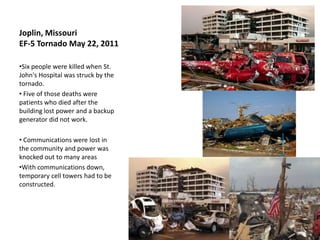
Joplin, Missouri
EF-5 TornadoMay 22, 2011
•Six people were killed when St.
John's Hospital was struck by the
tornado.
• Five of those deaths were
patients who died after the
building lost power and a backup
generator did not work.
• Communications were lost in
the community and power was
knocked out to many areas
•With communications down,
temporary cell towers had to be
constructed.
13.
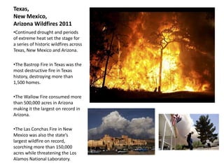
Texas,
New Mexico,
Arizona Wildfires2011
•Continued drought and periods
of extreme heat set the stage for
a series of historic wildfires across
Texas, New Mexico and Arizona.
•The Bastrop Fire in Texas was the
most destructive fire in Texas
history, destroying more than
1,500 homes.
•The Wallow Fire consumed more
than 500,000 acres in Arizona
making it the largest on record in
Arizona.
•The Las Conchas Fire in New
Mexico was also the state’s
largest wildfire on record,
scorching more than 150,000
acres while threatening the Los
Alamos National Laboratory.
14.
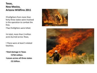
Texas,
New Mexico,
Arizona Wildfires2011
•Firefighters from more than
forty-three states were involved
in the operation to combat the
fires.
•Two firefighters were killed.
•In total, more than 3 million
acres burned across Texas.
• There were at least 5 related
fatalities.
•Total damage in Texas
•$750 million.
•Losses across all three states
•$1 billion.
15.
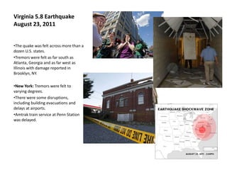
Virginia 5.8 Earthquake
August23, 2011
•The quake was felt across more than a
dozen U.S. states.
•Tremors were felt as far south as
Atlanta, Georgia and as far west as
Illinois with damage reported in
Brooklyn, NY.
•New York: Tremors were felt to
varying degrees.
•There were some disruptions,
including building evacuations and
delays at airports.
•Amtrak train service at Penn Station
was delayed.
16.
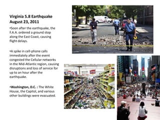
Virginia 5.8 Earthquake
August23, 2011
•Soon after the earthquake, the
F.A.A. ordered a ground stop
along the East Coast, causing
flight delays.
•A spike in cell-phone calls
immediately after the event
congested the Cellular networks
in the Mid-Atlantic region, causing
disruptions and loss of service for
up to an hour after the
earthquake.
•Washington, D.C. : The White
House, the Capitol, and various
other buildings were evacuated.
17.
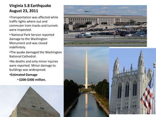
Virginia 5.8 Earthquake
August23, 2011
•Transportation was affected while
traffic lights where out and
commuter train tracks and tunnels
were inspected.
• National Park Service reported
damage to the Washington
Monument and was closed
indefinitely.
•The quake damaged the Washington
National Cathedral.
•No deaths and only minor injuries
were reported. Minor damage to
buildings was widespread.
•Estimated Damage
• $200-$300 million.
18.
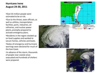
Hurricane Irene
August 24-30,2011
•Over 65 million people were
estimated to be at risk.
•Due to the threat, state officials, as
well as utilities, transportation
facilities, ports, industries, oil
refineries, and nuclear power
plants, promptly prepared to
activate emergency plans.
•Residents in the region stocked up
on food supplies and worked to
secure homes, vehicles and boats.
•States of emergency and hurricane
warnings were declared for much of
the East Coast.
•In advance of the storm, thousands
of people near coastal areas
evacuated and hundreds of shelters
were prepared.
19.
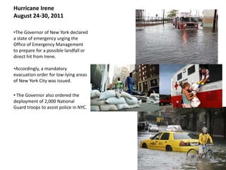
Hurricane Irene
August 24-30,2011
•The Governor of New York declared
a state of emergency urging the
Office of Emergency Management
to prepare for a possible landfall or
direct hit from Irene.
•Accordingly, a mandatory
evacuation order for low-lying areas
of New York City was issued.
• The Governor also ordered the
deployment of 2,000 National
Guard troops to assist police in NYC.
20.
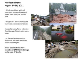
Hurricane Irene
August 24-30,2011
• Winds, combined with soil
saturation, uprooted trees and
power lines along the storm's
path.
• Roughly 7.4 million homes and
businesses lost electrical power.
•Coastal areas suffered extensive
flood damage following the storm
surge.
• In the northeastern region,
more than ten rivers measured
record flood heights.
•Irene is estimated to have
caused over $7 billion in damage
and at least 47 deaths.
21.
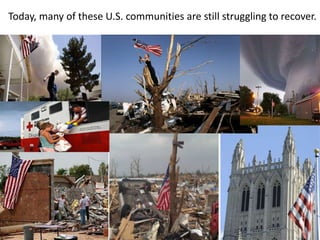
Today, many ofthese U.S. communities are still struggling to recover.
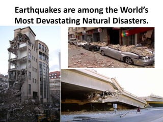
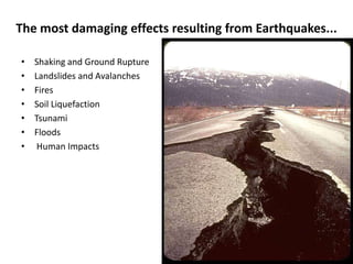
The most damagingeffects resulting from Earthquakes...
• Shaking and Ground Rupture
• Landslides and Avalanches
• Fires
• Soil Liquefaction
• Tsunami
• Floods
• Human Impacts
26.
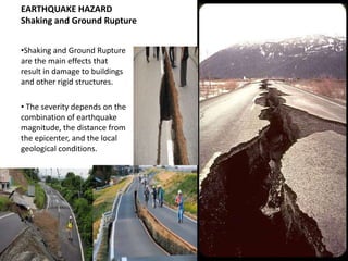
EARTHQUAKE HAZARD
Shaking andGround Rupture
•Shaking and Ground Rupture
are the main effects that
result in damage to buildings
and other rigid structures.
• The severity depends on the
combination of earthquake
magnitude, the distance from
the epicenter, and the local
geological conditions.
27.
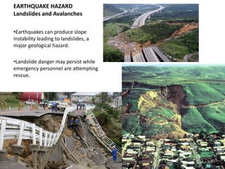
EARTHQUAKE HAZARD
Landslides andAvalanches
•Earthquakes can produce slope
instability leading to landslides, a
major geological hazard.
•Landslide danger may persist while
emergency personnel are attempting
rescue.
28.
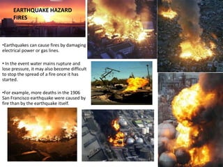
EARTHQUAKE HAZARD
FIRES
•Earthquakes can cause fires by damaging
electrical power or gas lines.
• In the event water mains rupture and
lose pressure, it may also become difficult
to stop the spread of a fire once it has
started.
•For example, more deaths in the 1906
San Francisco earthquake were caused by
fire than by the earthquake itself.
29.
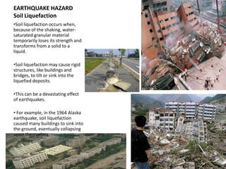
EARTHQUAKE HAZARD
Soil Liquefaction
•Soilliquefaction occurs when,
because of the shaking, water-
saturated granular material
temporarily loses its strength and
transforms from a solid to a
liquid.
•Soil liquefaction may cause rigid
structures, like buildings and
bridges, to tilt or sink into the
liquefied deposits.
•This can be a devastating effect
of earthquakes.
• For example, in the 1964 Alaska
earthquake, soil liquefaction
caused many buildings to sink into
the ground, eventually collapsing
upon themselves.
30.
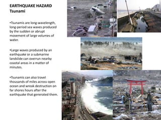
EARTHQUAKE HAZARD
Tsunami
•Tsunamis arelong-wavelength,
long-period sea waves produced
by the sudden or abrupt
movement of large volumes of
water.
•Large waves produced by an
earthquake or a submarine
landslide can overrun nearby
coastal areas in a matter of
minutes.
•Tsunamis can also travel
thousands of miles across open
ocean and wreak destruction on
far shores hours after the
earthquake that generated them.
31.
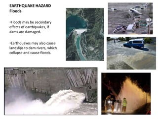
EARTHQUAKE HAZARD
Floods
•Floods maybe secondary
effects of earthquakes, if
dams are damaged.
•Earthquakes may also cause
landslips to dam rivers, which
collapse and cause floods.
32.
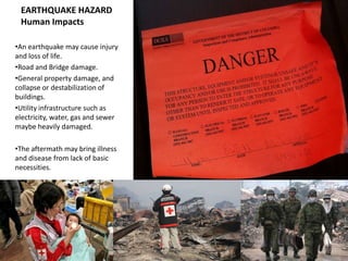
EARTHQUAKE HAZARD
HumanImpacts
•An earthquake may cause injury
and loss of life.
•Road and Bridge damage.
•General property damage, and
collapse or destabilization of
buildings.
•Utility infrastructure such as
electricity, water, gas and sewer
maybe heavily damaged.
•The aftermath may bring illness
and disease from lack of basic
necessities.
Scientists can, basedupon historical records and geological data,
estimate the probability of recurrence.
35.
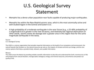
U.S. Geological Survey
Statement
• Memphis has a dense urban population near faults capable of producing major earthquakes.
• Memphis lies within the New Madrid seismic zone, which is the most seismically active and
well-studied region in the Central and Eastern U.S.
• A high probability of a moderate earthquake in the near future (e.g., a 25-40% probability of
a magnitude 6.0 or greater in the next 50 years), and relatively low regional attenuation (in
other words, seismic waves do damage over a greater area in this region than for the same
magnitude earthquake in the west).
Source:
U.S. Geological Survey
The USGS is a science organization that provides impartial information on the health of our ecosystems and environment, the
natural hazards that threaten us, the natural resources we rely on, the impacts of climate and land-use change, and the core
science systems that help us provide timely, relevant, and useable information.
Mission
The USGS serves the Nation by providing reliable scientific information to describe and understand the Earth; minimize loss of life
and property from natural disasters; manage water, biological, energy, and mineral resources; and enhance and protect our
quality of life.
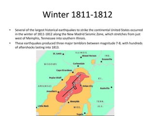
Winter 1811-1812
• Several of the largest historical earthquakes to strike the continental United States occurred
in the winter of 1811-1812 along the New Madrid Seismic Zone, which stretches from just
west of Memphis, Tennessee into southern Illinois.
• These earthquakes produced three major temblors between magnitude 7-8, with hundreds
of aftershocks lasting into 1813.
39.
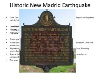
Historic New MadridEarthquake
• From Dec. 16, 1811 to Feb. 7, 1812 our region was rocked by three of the largest earthquakes
ever to hit the continental United States.
• December 16, 1811 - Magnitude ~7.7
• January 23, 1812 - Magnitude ~ 7.5
• February 7, 1812 - Magnitude ~ 7.7
• These quakes were felt widely over the entire eastern United States.
• In the epicentral area the ground surface was described as in great convulsion with sand and
water ejected into the air (liquefaction).
• Reports state the area was characterized by general ground warping, ejections, fissuring,
severe landslides, and caving of stream banks.
• Several destructive shocks occurred on February 7, 1812, the last of which equaled or
surpassed the magnitude of any previous event.
• The town of New Madrid was destroyed.
41.
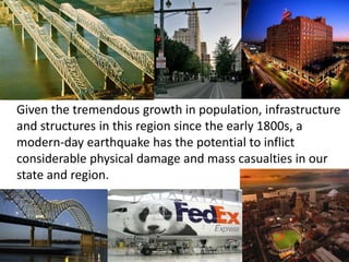
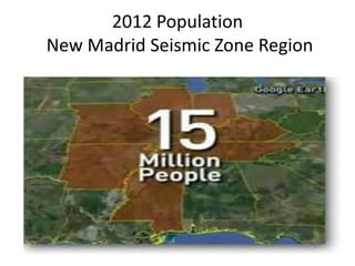
FAST FORWARD 200YEARS
FEBUARY 7, 2012
Given the tremendous growth in population, infrastructure
and structures in this region since the early 1800s, a
modern-day earthquake has the potential to inflict
considerable physical damage and mass casualties in our
state and region.
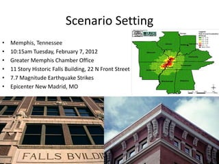
Scenario Setting
• Memphis, Tennessee
• 10:15am Tuesday, February 7, 2012
• Greater Memphis Chamber Office
• 11 Story Historic Falls Building, 22 N Front Street
• 7.7 Magnitude Earthquake Strikes
• Epicenter New Madrid, MO
44.
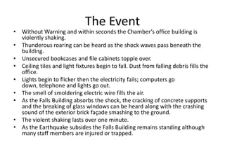
The Event
• WithoutWarning and within seconds the Chamber’s office building is
violently shaking.
• Thunderous roaring can be heard as the shock waves pass beneath the
building.
• Unsecured bookcases and file cabinets topple over.
• Ceiling tiles and light fixtures begin to fall. Dust from falling debris fills the
office.
• Lights begin to flicker then the electricity fails; computers go
down, telephone and lights go out.
• The smell of smoldering electric wire fills the air.
• As the Falls Building absorbs the shock, the cracking of concrete supports
and the breaking of glass windows can be heard along with the crashing
sound of the exterior brick façade smashing to the ground.
• The violent shaking lasts over one minute.
• As the Earthquake subsides the Falls Building remains standing although
many staff members are injured or trapped.
45.
The Emergency Response
• Immediately following the Earthquake, emergency first responders are quickly overwhelmed
with multiple calls for Medical, Fire and Police.
• Damage to transportation infrastructure hinders their response further.
• The Greater Memphis Chamber is fortunate; It’s staff knew what do in the event of an
Earthquake.
• The Chamber also has emergency supplies on-hand, and half its staff trained in CERT and
Basic First Aid.
• While only trained as volunteers, the staff’s knowledge, skills and leadership will prove to be
invaluable immediately following the disaster.
• Several staff members are trapped or missing and many injuries are reported but, No
Fatalities to the Chamber Staff.