Earth quake methodolgy
•Download as PPTX, PDF•
0 likes•247 views

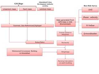
The document discusses conducting a bore hole survey to generate data on soil, shear velocity, groundwater levels and N-values which are analyzed in a GIS system using techniques like inverse distance weighted interpolation and reclassification to determine suitable locations for multistoried government buildings in Ahmedabad. The survey utilizes lineament maps, fault maps, landuse maps, GPS data and GSI maps.
Recommended

Recommended
More Related Content
What's hot
What's hot (20)
More from IEI GSC
More from IEI GSC (20)
Recently uploaded
Recently uploaded (20)
Earth quake methodolgy
- 1. Bore Hole Survey Lineament maps Fault maps Landuse maps Scanned, Geo-Referenced,Digitiged Rules(Table) Soil Shear velocity N-Value Groundwater Data generated from GPS Data in GIS Environment Inverse Distance Weighted Reclassify WeightageMultistoried Government Building in Ahmedabad Ranking Calculation on each building Ahmedabad Urban Development Authority (AUDA) GSI Maps