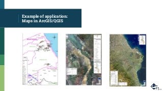
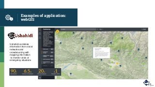
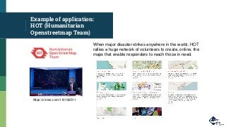
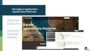
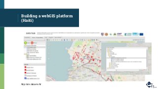
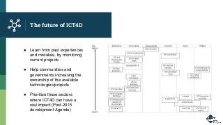
ICT4D
How technology and (geo)information
can serve development
Index
1. Gnucoop profile
2. ICT4D
▫ What is it? general overview
▫ Examples of projects/applications from Gnucoop
▫ ICT4D challenges and implementation steps
3. Geo-information for development
▫ General overview
▫ Examples of applications
▫ Lessons learnt
4. Gnucoop experience with geo-information for development
▫ Malawi case study → from PRA maps to satellite images
▫ Jordan, Service Advisor→Digital Humanitarian Network (DHN)
▫ Haiti case study → webGIS
5. The future of ICT4D
6. Q&A
Gnucoop
profile
Let’s see what Gnucoop is.
Gnucoop- Company Profile
▪ Our vision
We believe that free software and technologies can
help to improve quality of life and reduce the gap
between communities worldwide.
▪ Our mission
We design and develop software solutions with the
highest standards and the latest technologies. Our
core business is to develop ict4d solutions for the
nonprofit sector.
Gnucoop- Company Profile
▪ Our history
▫ since 2006 we develop solutions and work in cooperation projects
▫ cooperative officially established in 2012
▫ 70 clients in the last three years, including NGOs and aid agencies
▪ Our team
▫ developers - over 12 years experience
▫ system admin - over 15 years experience
▫ web designers - over 12 years experience
▫ cooperation experts/project managers- over 7 years experience
▪ Our skills
▫ building databases, complex data infrastructures, web interfaces
▫ developing web and mobile applications (data collection)
▫ trainings and e-learning platform
Gnucoop- Company Profile
▪ Our work
▫ web applications and website
▫ developing and managing e-
learning platform
▫ ICT4D and webGIS applications -
data collection/elaboration
▫ training on new technologies for
development
ICT4D
Let’s talk about ICT for development
What’s ICT4D for you?
▪…
▪….
ICT4D definition
Information and Communication Technologies for Development is an initiative aimed
at bridging the digital divide and aiding economic development by ensuring equitable
access to up-to-date communications technologies. Information and communication
technologies (ICTs) include any communication device -- encompassing radio,
television, cellular phones, computer and network hardware and software, satellite
systems and so on, as well as the various services and applications associated with
them, such as videoconferencing and distance learning.
From techtarget
Behind ICT4D:
▪ Increasing number of mobile phones in the developing world
▪ Increasing access to cheaper technologies
▪ Widespread of broadband connection
ICT4D: A bit of history
▪ 50’s-70’s: ICT4G (growth/government) or ICT4D 0.0
▪ 80’s: ICT mostly used in the private sector, only few experiences for the cooperation sector
(radio Sutatenza in the Andes)
▪ 90’s: ICT4D 1.0; World Wide Web and MDGs change the scenery, MDG #8 (Develop a global
partnership for development & avail benefits of new technologies): access to knowledge→
internet connections (i.e.: telecenters)
▪ 2000’s: ICT4D 2.0, using existing technologies and focusing on their application/users→
change of prospective: users are part of the technological process→ new open and shared
tools
● Digital technologies, new tools in search of a purpose
● DMGs, new targets in search of a delivery mechanism
ICT4D was the combination of the two elements.
ICT4D Tools - examples
Most popular ICT4D tools:
▪ Open Data Kit→ data
collection through forms
▪ FrontlineSMS→ data
collection through SMS
▪ Ushahidi→ crowdmapping
ICT4D applications:
▪ ehealth
▪ microfinance
▪ agriculture/food security
▪ humanitarian crisis
▪ disaster preparedness/response
But also… education, governance, democracy, etc..
ICT4D applications:
EXAMPLE 1-ehealth
▪ Remote diagnosis
▪ Outbreak monitoring
▪ Medical records
▪ Treatment adherence
▪ Drug supply chain
management
▪ Health campaigns
▪ Telemedicine
Stock Management via SMS
and Ushahidi in Madagascar
(Gnucoop/COOPI)
ICT4D applications:
EXAMPLE 2 -Finance
▪ Mobile-money- (i.e.: M-Pesa
customers can deposit and
withdraw money from a network
of agents that includes airtime
resellers and retail outlets acting
as banking agents.)
▪ Micro-loans monitoring:
managing savings and loans of
remote communities, who have
otherwise no access to
traditional financial services
Community Loans Management via odk
app in Malawi (Gnucoop/CUMO)
▪ Monitoring Food supplies
▪ Monitoring Food prices at
local markets
▪ Food Aid management
▪ Promoting Agricultural
education through video,
podcast, etc...
▪ Optimizing yield
ICT4D applications:
EXAMPLE 3- food security
Food Price monitoring via odk app in Central
African Republique (Gnucoop/ACF)
ICT4D applications:
EXAMPLE 4- humanitarian
emergencies
Twine: UNHCR/Gnucoop
Supporting data
collection and analysis of
information at refugee
camps worldwide.
A good example of the
evolution of ICTtools:
(excel,access,webapp)
ICT4D Challenges
Sustainability: ensuring project longevity,
→ government or local ownership is crucial
Scalability: from pilot to large scale project:
→ ability to propose a solution that can
impact large population
Evaluation: impact analysis
→ keep monitoring the application year
after year
Uganda, fragmentation of
mhealth projects MAP
Steps for the
implementation of ICT4D
projects
1 Assessing the potential of ICTs
1 Assessing the potential of
ICTs
4 Review
2 Assessing the social context
for ICTs
3 Assessing the physical
context of ICTs
7 Capacity building
6 Planning for sustainability
5 Choosing the ICT
8 Monitoring, evaluation and
sharing knowledge
Suggestions for a
successful ICT4D project
1. Build for what people already have in their hands
2. If your product needs an installation guide, that’s a barrier.
3. Projects have to be sustainable, but by charging users you often put barriers up to
adoption.
4. If you need to fly in and out to carry out installation, you’re going to struggle to get to scale
5. If you build your ICT4D tool to work without the Internet, then it will work anywhere.
6. Community is absolutely critical (users can connect and provide technical support to one
another)
7. We need to think of appropriate technology as a discipline
8. Collaboration is key
9. Think beyond technology
10.Don’t lose sight of the bigger picture. Ask yourself every day why you’re doing what you’re
doing, and whether it gets you any closer to that wider goal.
(Ken Banks)
Geoinformation
for
development
Let’s talk about geoinformation
Why Geo-information for
development?
▪ First proto-GIS→ Dr. John Snow, London Cholera Map 1854
▪ The first computer system for merging spatial information with statistical data
was the Canadian Geographic Information System (CGIS) made in the 60s and 70s
by Roger Tomlinson, also known the “Father of GIS”.
Why Geo-information for
development?
▪ First map made by Tomlinson was to determine a good location for planting trees
to feed a planned paper mill in Kenya
▪ GIS was mainly seen as a control tool, imperialistic geography ( explicit goal of
expanding political and economic control over those already disadvantaged by
local, regional, and global divisions of power: business, administration and war
purposes)
▪ In the 90s/2000s, emerging of Participatory GIS (PGIS) → bringing technology
closer to people; PRA mapping, communities getting knowledge and awareness of
theirs space (i.e.: Mapping water resources in KOFFIEKRAAL)
▪ 2010 Haiti earthquake
Milestone:
Haiti earthquake 2010
Mapping? No, Crowdmapping!
2010 Haiti earthquake , access to mobile and online
communication enabled a kind of collective
intelligence to emerge (V&TCs) to help make sense of
a large scale calamity and give voice to an affected
population.
Example of application:
Maps in ArcGIS/QGIS
Examples of application:
webGIS
Ushahidi combines
information from social
networks and
crowdsourcing with
mapping information
to monitor crisis or
emergency situations
Example of application:
HOT (Humanitarian
Openstreetmap Team)
When major disaster strikes anywhere in the world, HOT
rallies a huge network of volunteers to create, online, the
maps that enable responders to reach those in need.
https://vimeo.com/110162511
Example of application:
Spatial Data Platforms
National
platform
example:
Masdap-
Malawi
Other Examples of
application of geo for dev
...to the use of mapping
drones for early
recovery from Disasters
From simple 3W
platform...
Droneadventures
Lesson learnt:
good mapping for development
▪ store and back up essential baseline geospatial datasets so that they can be used immediately
once a disaster occurs
▪ Introduce and provide training in new ICT tools and information systems in advance of
emergencies
▪ Make critical data and information sharable with the host government, civil society and affected
populations (in local languages)
▪ data should include essential meta-data (source, date-stamp, geo-reference) and adheres to
the Principles of Humanitarian Information Management, i.e. accessibility, accountability,
impartiality, inclusiveness, interoperability, relevance, sensitivity, sustainability, timeliness and
verifiability.
▪ Simply making enormous amounts of data and information available and introducing new
technologies is not enough to ensure efficient coordination and effective decision-making.
Gnucoop and
geoinformation
for
development
Let’s see some examples
developed by Gnucoop
Creation of Hazard Maps
(Malawi case study)
● Community mapping (PRA maps) using
VHR satellite images
● GPS data collection
● Participatory GIS in rural communities
affected by floods to highlight hazards and
risk areas
● Data integration into maps
Mapping for disaster response
DHN Service Advisor
(Gnucoop/PeaceGeeks/
UNHCR Jordan)
http://data.unhcr.org/jordan/services-advisor/
Building a webGIS platform
(Haiti)
http://sirv.tabarre.ht/
The future of
ICT4D
Let’s see what’s on the plate for the
future
The future of ICT4D
● Learn from past experiences
and mistakes, by monitoring
current projects
● Help communities and
governments increasing the
ownership of the available
technologies/projects
● Prioritize those sectors
where ICT4D can have a
real impact (Post-2015
development Agenda)
Q&A
It’s your turn!
Gnucoop
IT for non profit
If you want to find out more,
please visit our website:
www.gnucoop.com
paola.fava@gnucoop.com
Thanks!

The use of Digital Tools and Geoinformation for Development

  • 1.
    ICT4D How technology and(geo)information can serve development
  • 2.
    Index 1. Gnucoop profile 2.ICT4D ▫ What is it? general overview ▫ Examples of projects/applications from Gnucoop ▫ ICT4D challenges and implementation steps 3. Geo-information for development ▫ General overview ▫ Examples of applications ▫ Lessons learnt 4. Gnucoop experience with geo-information for development ▫ Malawi case study → from PRA maps to satellite images ▫ Jordan, Service Advisor→Digital Humanitarian Network (DHN) ▫ Haiti case study → webGIS 5. The future of ICT4D 6. Q&A
  • 3.
  • 4.
    Gnucoop- Company Profile ▪Our vision We believe that free software and technologies can help to improve quality of life and reduce the gap between communities worldwide. ▪ Our mission We design and develop software solutions with the highest standards and the latest technologies. Our core business is to develop ict4d solutions for the nonprofit sector.
  • 5.
    Gnucoop- Company Profile ▪Our history ▫ since 2006 we develop solutions and work in cooperation projects ▫ cooperative officially established in 2012 ▫ 70 clients in the last three years, including NGOs and aid agencies ▪ Our team ▫ developers - over 12 years experience ▫ system admin - over 15 years experience ▫ web designers - over 12 years experience ▫ cooperation experts/project managers- over 7 years experience ▪ Our skills ▫ building databases, complex data infrastructures, web interfaces ▫ developing web and mobile applications (data collection) ▫ trainings and e-learning platform
  • 6.
    Gnucoop- Company Profile ▪Our work ▫ web applications and website ▫ developing and managing e- learning platform ▫ ICT4D and webGIS applications - data collection/elaboration ▫ training on new technologies for development
  • 7.
    ICT4D Let’s talk aboutICT for development
  • 8.
    What’s ICT4D foryou? ▪… ▪….
  • 9.
    ICT4D definition Information andCommunication Technologies for Development is an initiative aimed at bridging the digital divide and aiding economic development by ensuring equitable access to up-to-date communications technologies. Information and communication technologies (ICTs) include any communication device -- encompassing radio, television, cellular phones, computer and network hardware and software, satellite systems and so on, as well as the various services and applications associated with them, such as videoconferencing and distance learning. From techtarget Behind ICT4D: ▪ Increasing number of mobile phones in the developing world ▪ Increasing access to cheaper technologies ▪ Widespread of broadband connection
  • 10.
    ICT4D: A bitof history ▪ 50’s-70’s: ICT4G (growth/government) or ICT4D 0.0 ▪ 80’s: ICT mostly used in the private sector, only few experiences for the cooperation sector (radio Sutatenza in the Andes) ▪ 90’s: ICT4D 1.0; World Wide Web and MDGs change the scenery, MDG #8 (Develop a global partnership for development & avail benefits of new technologies): access to knowledge→ internet connections (i.e.: telecenters) ▪ 2000’s: ICT4D 2.0, using existing technologies and focusing on their application/users→ change of prospective: users are part of the technological process→ new open and shared tools ● Digital technologies, new tools in search of a purpose ● DMGs, new targets in search of a delivery mechanism ICT4D was the combination of the two elements.
  • 11.
    ICT4D Tools -examples Most popular ICT4D tools: ▪ Open Data Kit→ data collection through forms ▪ FrontlineSMS→ data collection through SMS ▪ Ushahidi→ crowdmapping
  • 12.
    ICT4D applications: ▪ ehealth ▪microfinance ▪ agriculture/food security ▪ humanitarian crisis ▪ disaster preparedness/response But also… education, governance, democracy, etc..
  • 13.
    ICT4D applications: EXAMPLE 1-ehealth ▪Remote diagnosis ▪ Outbreak monitoring ▪ Medical records ▪ Treatment adherence ▪ Drug supply chain management ▪ Health campaigns ▪ Telemedicine Stock Management via SMS and Ushahidi in Madagascar (Gnucoop/COOPI)
  • 14.
    ICT4D applications: EXAMPLE 2-Finance ▪ Mobile-money- (i.e.: M-Pesa customers can deposit and withdraw money from a network of agents that includes airtime resellers and retail outlets acting as banking agents.) ▪ Micro-loans monitoring: managing savings and loans of remote communities, who have otherwise no access to traditional financial services Community Loans Management via odk app in Malawi (Gnucoop/CUMO)
  • 15.
    ▪ Monitoring Foodsupplies ▪ Monitoring Food prices at local markets ▪ Food Aid management ▪ Promoting Agricultural education through video, podcast, etc... ▪ Optimizing yield ICT4D applications: EXAMPLE 3- food security Food Price monitoring via odk app in Central African Republique (Gnucoop/ACF)
  • 16.
    ICT4D applications: EXAMPLE 4-humanitarian emergencies Twine: UNHCR/Gnucoop Supporting data collection and analysis of information at refugee camps worldwide. A good example of the evolution of ICTtools: (excel,access,webapp)
  • 17.
    ICT4D Challenges Sustainability: ensuringproject longevity, → government or local ownership is crucial Scalability: from pilot to large scale project: → ability to propose a solution that can impact large population Evaluation: impact analysis → keep monitoring the application year after year Uganda, fragmentation of mhealth projects MAP
  • 18.
    Steps for the implementationof ICT4D projects 1 Assessing the potential of ICTs 1 Assessing the potential of ICTs 4 Review 2 Assessing the social context for ICTs 3 Assessing the physical context of ICTs 7 Capacity building 6 Planning for sustainability 5 Choosing the ICT 8 Monitoring, evaluation and sharing knowledge
  • 19.
    Suggestions for a successfulICT4D project 1. Build for what people already have in their hands 2. If your product needs an installation guide, that’s a barrier. 3. Projects have to be sustainable, but by charging users you often put barriers up to adoption. 4. If you need to fly in and out to carry out installation, you’re going to struggle to get to scale 5. If you build your ICT4D tool to work without the Internet, then it will work anywhere. 6. Community is absolutely critical (users can connect and provide technical support to one another) 7. We need to think of appropriate technology as a discipline 8. Collaboration is key 9. Think beyond technology 10.Don’t lose sight of the bigger picture. Ask yourself every day why you’re doing what you’re doing, and whether it gets you any closer to that wider goal. (Ken Banks)
  • 20.
  • 21.
    Why Geo-information for development? ▪First proto-GIS→ Dr. John Snow, London Cholera Map 1854 ▪ The first computer system for merging spatial information with statistical data was the Canadian Geographic Information System (CGIS) made in the 60s and 70s by Roger Tomlinson, also known the “Father of GIS”.
  • 22.
    Why Geo-information for development? ▪First map made by Tomlinson was to determine a good location for planting trees to feed a planned paper mill in Kenya ▪ GIS was mainly seen as a control tool, imperialistic geography ( explicit goal of expanding political and economic control over those already disadvantaged by local, regional, and global divisions of power: business, administration and war purposes) ▪ In the 90s/2000s, emerging of Participatory GIS (PGIS) → bringing technology closer to people; PRA mapping, communities getting knowledge and awareness of theirs space (i.e.: Mapping water resources in KOFFIEKRAAL) ▪ 2010 Haiti earthquake
  • 23.
    Milestone: Haiti earthquake 2010 Mapping?No, Crowdmapping! 2010 Haiti earthquake , access to mobile and online communication enabled a kind of collective intelligence to emerge (V&TCs) to help make sense of a large scale calamity and give voice to an affected population.
  • 24.
  • 25.
    Examples of application: webGIS Ushahidicombines information from social networks and crowdsourcing with mapping information to monitor crisis or emergency situations
  • 26.
    Example of application: HOT(Humanitarian Openstreetmap Team) When major disaster strikes anywhere in the world, HOT rallies a huge network of volunteers to create, online, the maps that enable responders to reach those in need. https://vimeo.com/110162511
  • 27.
    Example of application: SpatialData Platforms National platform example: Masdap- Malawi
  • 28.
    Other Examples of applicationof geo for dev ...to the use of mapping drones for early recovery from Disasters From simple 3W platform... Droneadventures
  • 29.
    Lesson learnt: good mappingfor development ▪ store and back up essential baseline geospatial datasets so that they can be used immediately once a disaster occurs ▪ Introduce and provide training in new ICT tools and information systems in advance of emergencies ▪ Make critical data and information sharable with the host government, civil society and affected populations (in local languages) ▪ data should include essential meta-data (source, date-stamp, geo-reference) and adheres to the Principles of Humanitarian Information Management, i.e. accessibility, accountability, impartiality, inclusiveness, interoperability, relevance, sensitivity, sustainability, timeliness and verifiability. ▪ Simply making enormous amounts of data and information available and introducing new technologies is not enough to ensure efficient coordination and effective decision-making.
  • 30.
  • 31.
    Creation of HazardMaps (Malawi case study) ● Community mapping (PRA maps) using VHR satellite images ● GPS data collection ● Participatory GIS in rural communities affected by floods to highlight hazards and risk areas ● Data integration into maps
  • 32.
    Mapping for disasterresponse DHN Service Advisor (Gnucoop/PeaceGeeks/ UNHCR Jordan) http://data.unhcr.org/jordan/services-advisor/
  • 33.
    Building a webGISplatform (Haiti) http://sirv.tabarre.ht/
  • 34.
    The future of ICT4D Let’ssee what’s on the plate for the future
  • 35.
    The future ofICT4D ● Learn from past experiences and mistakes, by monitoring current projects ● Help communities and governments increasing the ownership of the available technologies/projects ● Prioritize those sectors where ICT4D can have a real impact (Post-2015 development Agenda)
  • 36.
  • 37.
    Gnucoop IT for nonprofit If you want to find out more, please visit our website: www.gnucoop.com paola.fava@gnucoop.com
  • 38.