Download to read offline
![Taghi Karimi / International Journal of Engineering Research and Applications (IJERA)
ISSN: 2248-9622 www.ijera.com Vol. 3, Issue 2, March -April 2013, pp.644-652
A Novel Expert System for Reasoning Based on Semantic Cancer
Taghi Karimi
Department of Mathematics, Payame Noor University, Tehran, Iran
Abstract
This paper describes a programmatic framework information between groups of people with differing
for representing, manipulating and reasoning with ontologies [5-9].
geographic semantics. The framework enables Semantic issues pervade the creation, use and re-
visualizing knowledge discovery, automating tool purposing of geographic information. In an
selection for user defined geographic problem information economy we can identify the roles of
solving, and evaluating semantic change in information producer and information consumer, and
knowledge discovery environments. Methods, in some cases, in national mapping agencies for
data, and human experts (our resources) are example, datasets are often constructed incrementally
described using ontologies. An entity’s ontology by different groups of people with an implicit (but
describes, where applicable: uses, inputs, outputs, not necessarily recorded) goal. The overall meaning
and semantic changes. These ontological of the resulting information products are not always
descriptions are manipulated by an expert system obvious to those outside that group, existing for the
to select methods, data and human experts to solve most part in the creators‘ mental model. When
a specific user-defined problem; that is, a solving a problem, a user may gather geospatial
semantic description of the problem is compared information from a variety of sources without ever
to the services that each entity can provide to encountering an explicit statement about what the
construct a graph of potential solutions. A data mean, or what they are (and are not) useful for.
minimal spanning tree representing the optimal Without capturing the semantics of the data
(least cost) solution is extracted from this graph, throughout the process of creation, the data may be
and displayed in real-time. The semantic misunderstood, be used inappropriately, or not used
change(s) that result from the interaction of data, at all when they could be. The consideration of
methods and people contained within the resulting geospatial semantics needs to explicitly cater for the
tree are determined via expressions of particular way in which geospatial tasks are
transformation semantics represented within the undertaken [10]. As a result, the underlying
JESS expert system shell. The resulting assumptions about methods used with data, and the
description represents the formation history of roles played by human expertise need to be
each new information product (such as a map or represented in some fashion so that a meaningful
overlay) and can be stored, indexed and searched association can be made between appropriate
as required. Examples are presented to show (1) methods, people and data to solve a problem. It is not
the construction and visualization of information the role of this paper to present a definitive taxonomy
products, (2) the reasoning capabilities of the of geographic operations or their semantics. To do so
system to find alternative ways to produce would trivialize the difficulties of defining
information products from a set of data methods geographic semantics
and expertise, given certain constraints and (3) the
representation of the ensuing semantic changes by II. Background and Aims
which an information product is synthesized. This paper presents a programmatic
framework for representing, manipulating and
I. Introduction reasoning with geographic semantics. In general
The importance of semantics in geographic semantics refers to the study of the relations between
information is well documented [1-4]. Semantics are symbols and what they represent [11]. In the
a key component of interoperability between GIS; framework outlined in this paper, semantics have two
there are now robust technical solutions to valuable and specific roles. Firstly, to determine the
interoperate geographic information in a syntactic most appropriate resources (method, data or human
and schematic sense (e.g. OGC, NSDI) but these fail expert) to use in concert to solve a geographic
to take account of any sense of meaning associated problem, and secondly to act as a measure of change
with the information. describe how exchanging data in meaning when data are operated on by methods
between systems often fails due to confusion in the and human experts. Both of these roles are discussed
meaning of concepts. Such confusion, or semantic in detail in Section 3. The framework draws on a
heterogeneity, significantly hinders collaboration if number of different research fields, specifically:
groups cannot agree on a common lexicon for core geographical semantics [11-13]ontologies
concepts. Semantic heterogeneity is also blamed for computational semantics, constraint-based reasoning
the inefficient exchange of geographic concepts and and expert systems and visualization to represent
644 | P a g e](https://image.slidesharecdn.com/dc32644652-130409052741-phpapp01/85/Dc32644652-1-320.jpg)
![Taghi Karimi / International Journal of Engineering Research and Applications (IJERA)
ISSN: 2248-9622 www.ijera.com Vol. 3, Issue 2, March -April 2013, pp.644-652
A Novel Expert System for Reasoning Based on Semantic Cancer
Taghi Karimi
Department of Mathematics, Payame Noor University, Tehran, Iran
Abstract
This paper describes a programmatic framework information between groups of people with differing
for representing, manipulating and reasoning with ontologies [5-9].
geographic semantics. The framework enables Semantic issues pervade the creation, use and re-
visualizing knowledge discovery, automating tool purposing of geographic information. In an
selection for user defined geographic problem information economy we can identify the roles of
solving, and evaluating semantic change in information producer and information consumer, and
knowledge discovery environments. Methods, in some cases, in national mapping agencies for
data, and human experts (our resources) are example, datasets are often constructed incrementally
described using ontologies. An entity’s ontology by different groups of people with an implicit (but
describes, where applicable: uses, inputs, outputs, not necessarily recorded) goal. The overall meaning
and semantic changes. These ontological of the resulting information products are not always
descriptions are manipulated by an expert system obvious to those outside that group, existing for the
to select methods, data and human experts to solve most part in the creators‘ mental model. When
a specific user-defined problem; that is, a solving a problem, a user may gather geospatial
semantic description of the problem is compared information from a variety of sources without ever
to the services that each entity can provide to encountering an explicit statement about what the
construct a graph of potential solutions. A data mean, or what they are (and are not) useful for.
minimal spanning tree representing the optimal Without capturing the semantics of the data
(least cost) solution is extracted from this graph, throughout the process of creation, the data may be
and displayed in real-time. The semantic misunderstood, be used inappropriately, or not used
change(s) that result from the interaction of data, at all when they could be. The consideration of
methods and people contained within the resulting geospatial semantics needs to explicitly cater for the
tree are determined via expressions of particular way in which geospatial tasks are
transformation semantics represented within the undertaken [10]. As a result, the underlying
JESS expert system shell. The resulting assumptions about methods used with data, and the
description represents the formation history of roles played by human expertise need to be
each new information product (such as a map or represented in some fashion so that a meaningful
overlay) and can be stored, indexed and searched association can be made between appropriate
as required. Examples are presented to show (1) methods, people and data to solve a problem. It is not
the construction and visualization of information the role of this paper to present a definitive taxonomy
products, (2) the reasoning capabilities of the of geographic operations or their semantics. To do so
system to find alternative ways to produce would trivialize the difficulties of defining
information products from a set of data methods geographic semantics
and expertise, given certain constraints and (3) the
representation of the ensuing semantic changes by II. Background and Aims
which an information product is synthesized. This paper presents a programmatic
framework for representing, manipulating and
I. Introduction reasoning with geographic semantics. In general
The importance of semantics in geographic semantics refers to the study of the relations between
information is well documented [1-4]. Semantics are symbols and what they represent [11]. In the
a key component of interoperability between GIS; framework outlined in this paper, semantics have two
there are now robust technical solutions to valuable and specific roles. Firstly, to determine the
interoperate geographic information in a syntactic most appropriate resources (method, data or human
and schematic sense (e.g. OGC, NSDI) but these fail expert) to use in concert to solve a geographic
to take account of any sense of meaning associated problem, and secondly to act as a measure of change
with the information. describe how exchanging data in meaning when data are operated on by methods
between systems often fails due to confusion in the and human experts. Both of these roles are discussed
meaning of concepts. Such confusion, or semantic in detail in Section 3. The framework draws on a
heterogeneity, significantly hinders collaboration if number of different research fields, specifically:
groups cannot agree on a common lexicon for core geographical semantics [11-13]ontologies
concepts. Semantic heterogeneity is also blamed for computational semantics, constraint-based reasoning
the inefficient exchange of geographic concepts and and expert systems and visualization to represent
644 | P a g e](https://image.slidesharecdn.com/dc32644652-130409052741-phpapp01/75/Dc32644652-1-2048.jpg)
![Taghi Karimi / International Journal of Engineering Research and Applications (IJERA)
ISSN: 2248-9622 www.ijera.com Vol. 3, Issue 2, March -April 2013, pp.644-652
aspects of these resources. The framework sets out to 1.1 Ontology
solve a multi-layered problem of visualizing In philosophy, Ontology is the ―study of the kinds of
knowledge discovery, automating tool selection for things that exist‖ In the artificial intelligence
user defined geographic problem solving and community, ontology has one of two meanings, as a
evaluating semantic change in knowledge discovery representation vocabulary, typically specialized to
environments. The end goal of the framework is to some domain or subject matter and as a body of
associate with geospatial information products the knowledge describing some domain using such a
details of their formation history and tools by which representation vocabulary [18]. The goal of sharing
to browse, query and ultimately understand this knowledge can be accomplished by encoding domain
formation history, thereby building a better knowledge using a standard vocabulary based on an
understanding of meaning and appropriate use of the ontology. The framework described here utilizes both
information. definitions of ontology.
The problem of semantic heterogeneity arises due to
the varying interpretations given to the terms used to
describe facts and concepts. Semantic heterogeneity
exists in two forms, cognitive and naming. Cognitive
semantic heterogeneity results from no common base
of definitions between two (or more) groups. As an
example, think of these as groups of scientists
attempting to collaborate. If the two groups cannot
agree on definitions for their core concepts then
collaboration between them will be problematic.
Defining such points of agreement amounts to
constructing a shared ontology, or at the very least,
points of overlap [12-17].
Naming semantic heterogeneity occurs when the
same name is used for different concepts or different
names are used for the same concept. It is not
possible to undertake any semantic analysis until
problems of semantic heterogeneity are resolved.
Ontologies, described below, are widely
recommended as a means of rectifying semantic
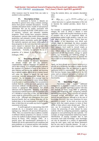
heterogeneity. The framework presented in this paper Figure 1 – Interrelationships between different types of
utilizes that work and other ontological research to ontology.
solve the problem of semantic heterogeneity.
The use of an expert system for automated reasoning
fits well with the logical semantics utilized within the
framework. The Java Expert System Shell (JESS) is
used to express diverse semantic aspects about
methods, data, and human experts. JESS performs
string comparisons of resource attributes (parsed
from ontologies) using backward chaining to
determine interconnections between resources.
Backward chaining is a goal driven problem solving
methodology, starting from the set of possible
solutions and attempting to derive the problem. If the
conditions for a rule to be satisfied are not found
within that rule, the engine searches for other rules
that have the unsatisfied rule as their conclusion,
establishing dependencies between rules. JESS
functions as a mediator system, with a foundation Figure 2 – Information products are
layer where the methods, data, and human experts are derived from the interaction of entities.
described (the domain ontology), a mediation layer
with a view of the system (the task ontology) and a The representation vocabulary embodies the
user interface layer (for receiving queries and conceptualizations that the terms in the vocabulary
displaying results). are intended to capture. Relationships described
between conceptual elements in this ontology allow
645 | P a g e](https://image.slidesharecdn.com/dc32644652-130409052741-phpapp01/85/Dc32644652-2-320.jpg)
![Taghi Karimi / International Journal of Engineering Research and Applications (IJERA)
ISSN: 2248-9622 www.ijera.com Vol. 3, Issue 2, March -April 2013, pp.644-652
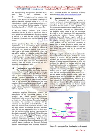
The first stage of the solution synthesis is the user The compare rule (Table 1) has dependencies on
specification of the problem using concepts and rules that collect data sources (used for comparisons)
keywords derived from a problem ontology. The and the rules that accomplish those comparisons
problem ontology, derived from the methods, data (intersection and union). If each of these rules can be
and human expert ontologies, consist of concepts satisfied on the ―if‖ side of the clause, then the results
describing the intended uses of each of the resources. of the comparison rules are stored, together with the
This limitation was introduced to ensure the data sources that were used in the comparison and the
framework had access to the necessary entities to products of the comparison. The results of the rule
solve a user‘s problem. A more advanced version of ―firing‖ are stored in a list that will be used to form a
the problem specification is proposed which uses minimal spanning tree for graphing [10-30].
natural language parsing to allow the user to specify a
problem. This query would then be mapped to the As the engine runs, each of the rules ―needed‖ are
problem ontology allowing the user to use their own satisfied using backward chaining, the goal is
semantics instead of being governed by those of the fulfilled, and a network of resources is constructed.
system. As each rule fires and populates the network a set of
criteria is added to a JESS fact describing each of the
The second stage of the solution synthesis process user criteria that limits the network. Each of these
parses the rules and facts describing relationships criteria is used to create a minimal spanning tree of
between data, methods, and human experts. The operations. User criteria are initially based upon the
JESS rule, compare (Table 1), illustrates the key spatial concepts of identity, location, direction,
interaction between the rule (or method) distance, magnitude, scale, time availability,
requirements and the facts (data and human experts). operation time, and semantic change.
Sections of the rule not essential for illustrating its
function have been removed. It is important to note Users specify the initial constraints, via the user
that these rules do not perform the operations interface (figure 6) prior to the automated selection of
described rather they mimic the semantic change that tools. As an example, a satellite image is required for
would accompany such an operation. The future an interpretation task, but the only available data is
work section outlines the goal of running this system 30 days old and data from the next orbit over the
in tandem with a codeless programming environment region will not be available for another 8 hours. Is it
to run the selected toolset automatically. ―better‖ to wait for that data to become available or is
Table 1 - JESS Sample code it more crucial to achieve a solution in a shorter time
(1) defrule compare ;; compare two data sets using potentially out of date data? It is possible that
(2) (need-comparison_result $?) the user will request a set of limiting conditions that
(3) (datasource_a ?srcA) are too strict to permit a solution. In these cases all
(4) (datasource_b ?srcB) possible solutions will be displayed allowing the user
(5) intersection_result <- (intersect ?srcA ?srcB) to modify their constraints. The user specified
(6) union_result <- (union ?srcA ?srcB) constraints are used to prune the network of resources
(7) => ;; THEN constructed (i.e. all possible solutions to the problem)
(8) (assert (comparison_result (inputA ?srcA) to a minimal spanning tree which is the solution that
(inputB ?srcB) (intersect ?intersection_result) (union satisfies all of the user‘s constraints.
?union_result) ;; ―perform‖ the operation
VII. Results
With all of the resource rules defined, the missing This section presents the results of the framework‘s
link is the problem to be solved using these rules. The
problem ontology is parsed into JESS to create a set
of facts. These facts form the ―goal‖ rule which
mirrors the user‘s problem specification. Each of the
facts in the ‗if‘ component of the goal rule are in the
form ‗need-method_x‘. The JESS engine now has the
requisite components for tool selection.
Utilizing backward-chaining JESS searches for rules
which satisfy the left hand side (LHS) of the rule. In
the case of dependencies (rules preceded by ―need-‖)
JESS searches for rules that satisfy the ―need-‖
request and runs them prior to running the rule
generating the request. The compare rule (above)
runs only when a previous rule requires a
comparison_result fact to be asserted in order for that
rule to be completed.
Figure 6 – Interface showing constraint selection.
650 | P a g e](https://image.slidesharecdn.com/dc32644652-130409052741-phpapp01/85/Dc32644652-7-320.jpg)
![Taghi Karimi / International Journal of Engineering Research and Applications (IJERA)
ISSN: 2248-9622 www.ijera.com Vol. 3, Issue 2, March -April 2013, pp.644-652
solution synthesis and representation of semantic IX. Conclusions
change. The results of the knowledge discovery This paper outlined a framework for
visualization are implicit in this discussion as that representing, manipulating and reasoning with
component is used for the display of the minimal geographic semantics. The framework enables
spanning tree. visualizing knowledge discovery, automating tool
selection for user defined geographic problem
A sample problem, finding a home location with a
sunset view is used to demonstrate the solution
synthesis. In order to solve this problem, raster
(DEM) and vector (road network) data needs to be
integrated. A raster overlay, using map algebra,
followed by buffer operations is required to find
suitable locations, from height, slope and aspect data.
The raster data of potential sites needs to be
converted to a vector layer to enable a buffering
operation with vector road data. Finally a viewshed
analysis is performed to determine how much of the
landscape is visible from candidate sites.
The problem specification was simplified by hard-
coding the user requirements into a set of facts loaded
from an XML file. The user‘s problem specification
was reduced to selecting pre-defined problems from a
menu.
A user constraint of scale was set to ensure that data
used by the methods in the framework was at a
consistent scale and appropriate data layers were
selected based on their metadata and format. With the Figure 7 – Diagram showing optimal path derived from
user requirements parsed into JESS and a problem thinned network
selected, the solution engine selected the methods,
data and human experts required to solve the solving, and evaluating semantic change in
problem. The solution engine constructed a set of all knowledge discovery environments. A minimal
possible combinations and then determined the spanning tree representing the optimal (least cost)
shortest path by summing the weighted constraints solution was extracted from this graph, and can be
specified by the user. Utilizing the abstract notation displayed in real-time. The semantic change(s) that
from above, with methods specifying change thus: result from the interaction of data, methods and
M 1 : D p1 , p 2 , , p n Operation D ' p1 ' , p 2 ' , the n 'formation history of each new information
,p
people contained within the resulting tree represents
, the user weights were included and summed for all product (such as a map or overlay) and can be stored,
modified data sets: indexed and searched as required.
D1 ' u1 p1 ' , u 2 p 2 ' ,, u n p n ',... Dn ' u1 p1 ' , u 2 p 2 ' ,, u n p n '
X. Acknowledgements
. As a result of this process the solution set is pruned
Our thanks go to Sachin Oswal, who helped
until only the optimal solution remains (based on user
with the customization of the TouchGraph concept
constraints).
visualization tool used here. This work is partly
funded by NSF grants: ITR (BCS)-0219025 and ITR
VIII. Future Work Geosciences Network (GEON).
The ultimate goal of this project is to
integrate the problem solving environment with the
References
codeless programming environment GEOVISTA
[1] Abel, D.J., Taylor, K., Ackland, R., and
Studio currently under development at Pennsylvania Hungerford, S. 1998, An Exploration of GIS
State University. The possibility of supplying data to Architectures for Internet Environments.
the framework and determining the types of questions Computers, Environment and Urban Systems.
which could be answered with it is also an interesting 22(1) pp 7 -23.
problem. [2] Albrecht, J., 1994. Universal elementary GIS
A final goal is the use of natural language parsing of tasks- beyond low-level commands. In Waugh T
the user‘s problem specification. C and Healey R G (eds) Sixth International
Symposium on Spatial Data Handling : 209-22.
651 | P a g e](https://image.slidesharecdn.com/dc32644652-130409052741-phpapp01/85/Dc32644652-8-320.jpg)
![Taghi Karimi / International Journal of Engineering Research and Applications (IJERA)
ISSN: 2248-9622 www.ijera.com Vol. 3, Issue 2, March -April 2013, pp.644-652
[3] Bishr, Y., 1997. Semantic aspects of interoperable Information Technology. Springer Verlag, pp.
GIS. Ph.D Dissertation Thesis, Enschede, The 139-170.
Netherlands, 154 pp. [17] Guarino, N., 1997b. Understanding , building and
[4] Bishr, Y., 1998. Overcoming the semantic and using ontologies. International Journal of Human-
other barriers to GIS interoperability. Computer Studies, 46: 293-310.
International Journal of Geographical [18] Hakimpour, F. and Timpf, S., 2002. A Step towards
Information Science, 12(4): 299-314. GeoData Integration using Formal Ontologies. In:
[5] Brodaric, B. and Gahegan, M., 2002. M. Ruiz, M. Gould and J. Ramon (Editors), 5th
Distinguishing Instances and Evidence of AGILE Conference on Geographic Information
Geographical Concepts for Geospatial Database Science. Universitat de les Illes Balears, Palma de
Design. In: M.J. Egenhofer and D.M. Mark Mallorca, Spain, pp. 5.
(Editors), GIScience 2002. Lecture Notes in [19] Honda, K. and Mizoguchi, F., 1995. Constraint-
Computing Science 2478. Springer-Verlag, pp. 22- based approach for automatic spatial layout
37. planning. 11th conference on Artificial Intelligence
[6] Chandrasekaran, B., Josephson, J.R. and Benjamins, for Applications, Los Angeles, CA. p38.
V.R., 1997. Ontology of Tasks and Methods, [20] Kokla, M. and Kavouras, M., 2002. Theories of
AAAI Spring Symposium. Concepts in Resolving Semantic Heterogeneities,
[7] Egenhofer, M., 2002. Toward the semantic 5th AGILE Conference on Geographic Information
geospatial web, Tenth ACM International Science, Palma, Spain, pp. 2.
Symposium on Advances in Geographic [21] Kuhn, W., 2002. Modeling the Semantics of
Information Systems. ACM Press, New York, Geographic Categories through Conceptual
NY, USA, McLean, Virginia, USA, pp. 1-4. Integration. In: M.J. Egenhofer and D.M. Mark
[8] Fabrikant, S.I. and Buttenfield, B.P., 2001. (Editors), GIScience 2002. Lecture Notes in
Formalizing Semantic Spaces for Information Computer Science. Springer-Verlag.
Access. Annals of the Association of American [22] MacEachren, A.M., in press. An evolving
Geographers, 91(2): 263-280. cognitive-semiotic approach to geographic
[9] Federal Geographic Data Committee. FGDC- visualization and knowledge construction.
STD-001-1998. Content standard for digital Information Design Journal.
geospatial metadata (revised June 1998). Federal [23] Mark, D., Egenhofer, M., Hirtle, S. and Smith, B.,
Geographic Data Committee. Washington, D.C. 2002. Ontological Foundations for Geographic
[10] Fonseca, F.T., 2001. Ontology-Driven Geographic Information Science. UCGIS Emerging Resource
Information Systems. Doctor of Philosophy Theme.
Thesis, The University of Maine, 131 pp. [24] Pascoe R.T and Penny J.P. (1995) Constructing
[11] Fonseca, F.T., Egenhofer, M.J., Jr., C.A.D. and interfaces between (and within) geographical
Borges, K.A.V., 2000. Ontologies and knowledge information systems. International Journal of
sharing in urban GIS. Computers, Environment Geographical Information Systems, 9:p275.
and Urban Systems, 24: 251-271. [25] Pundt, H. and Bishr, Y., 2002. Domain ontologies
[12] Fonseca, F.T. and Egenhofer, M.J., 1999. for data sharing–an example from environmental
Ontology-Driven Geographic Information monitoring using field GIS. Computers &
Systems. In: C.B. Medeiros (Editor), 7th ACM Geosciences, 28: 95-102.
Symposium on Advances in Geographic [26] Smith, B. and Mark, D.M., 2001. Geographical
Information Systems, Kansas City, MO, pp. 7. categories: an ontological investigation.
[13] Gahegan, M., Takatsuka, M., Wheeler, M. and International Journal of Geographical
Hardisty, F., 2002. Introducing GeoVISTA Information Science, 15(7): 591-612.
Studio: an integrated suite of visualization and [27] Sotnykova, A., 2001. Design and Implementation
computational methods for exploration and of Federation of Spatio-Temporal Databases:
knowledge construction in geography. Computers, Methods and Tools, Centre de Recherche Public -
Environment and Urban Systems, 26: 267-292. Henri Tudor and Laboratoire de Bases de Donnees
[14] Gahegan, M. N. (1999). Characterizing the Database Laboratory.
semantic content of geographic data, models, and [28] Sowa, J. F., 2000, Knowledge Representation:
systems. In Interoperating Geographic Logical, Philosophical and Computational
Information Systems (Eds. Goodchild, M.F., Foundations (USA: Brooks/Cole).
Egenhofer, M. J. Fegeas, R. and Kottman, C. A.). [29] Turner, M. and Fauconnier, G., 1998. Conceptual
Boston: Kluwer Academic Publishers, pp. 71-84. Integration Networks. Cognitive Science, 22(2):
[15] Gahegan, M. N. (1996). Specifying the 133-187.
transformations within and between geographic [30] Visser, U., Stuckenschmidt, H., Schuster, G. and
data models. Transactions in GIS, Vol. 1, No. 2, Vogele, T., 2002. Ontologies for geographic
pp. 137-152. information processing. Computers &
[16] Guarino, N., 1997a. Semantic Matching: Formal Geosciences, 28: 103-117.
Ontological Distinctions for Information
Organization, Extraction, and Integration. In: M.T.
Pazienza (Editor), Information Extraction: A
Multidisciplinary Approach to an Emerging
652 | P a g e](https://image.slidesharecdn.com/dc32644652-130409052741-phpapp01/85/Dc32644652-9-320.jpg)

This paper presents a programmatic framework for reasoning with geographic semantics, focusing on the interaction between data, methods, and human expertise to create meaningful geospatial information products. It highlights the importance of ontologies in resolving semantic heterogeneity and enabling effective knowledge discovery and decision-making. The framework utilizes the Java Expert System Shell (JESS) to automate the selection of appropriate resources and evaluate semantic changes throughout the process of problem-solving.


