Download to read offline


![Data Driven Pages -
Python Code
import fme, fmeobjects, time, arcpy
def FeatureProcessor(feature):
map = FME_MacroValues['MAP']
output_folder = FME_MacroValues['OUTPUT_FOLDER']
mxd = arcpy.mapping.MapDocument(map)
mxd.dataDrivenPages.refresh() # Previous to the python script a shape file is written with bounding boxes. This shape file is already added to the mxd
logger = fmeobjects.FMELogFile()
logger.logMessageString("Generating maps based on the difference between the databases:")
for pageNum in range(1, mxd.dataDrivenPages.pageCount + 1):
mxd.dataDrivenPages.currentPageID = pageNum
logger.logMessageString("MAP_"+str(pageNum)+" is now beeing generated.")
arcpy.mapping.ExportToPNG(mxd, output_folder + "MAP_" + str(pageNum) + ".png", resolution=200, color_mode="24-BIT_TRUE_COLOR")
time.sleep(2) # It is important to sleep the script, so that larger maps has time to load completely before the next image is generated
del mxd
pass](https://image.slidesharecdn.com/henrikthoren-databasecomparisonandarcmapdatadrivenpages-170601205129/85/Database-Comparison-and-ArcMap-Data-Driven-Pages-13-320.jpg)


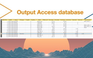
The document describes a solution for dynamic hydrological and hydraulic simulations using Mike Urban integrated with ArcMap. It highlights the use of FME's database comparison tools to automate updates and create maps displaying attribute changes. Additionally, a Python script is provided for generating data-driven pages in ArcMap based on database differences.


