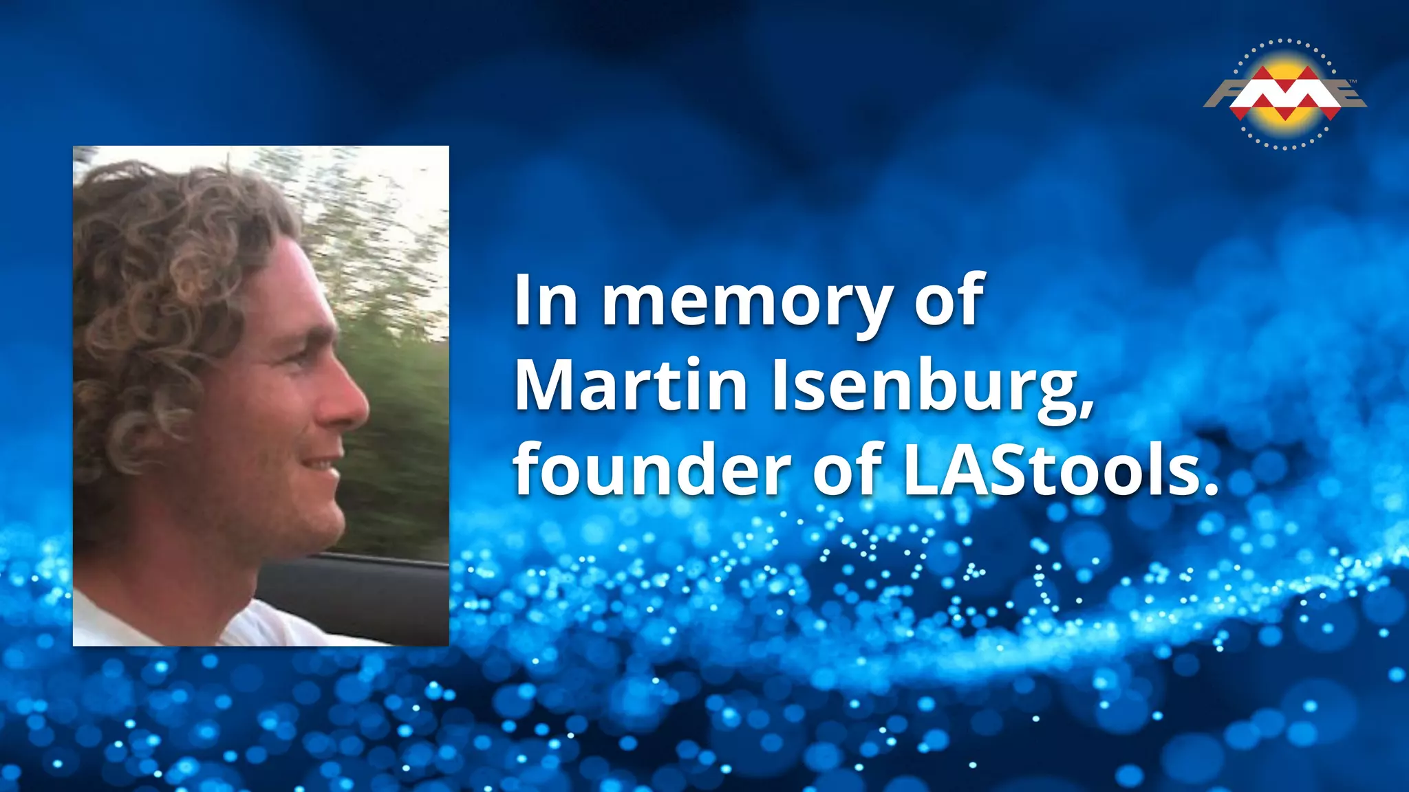
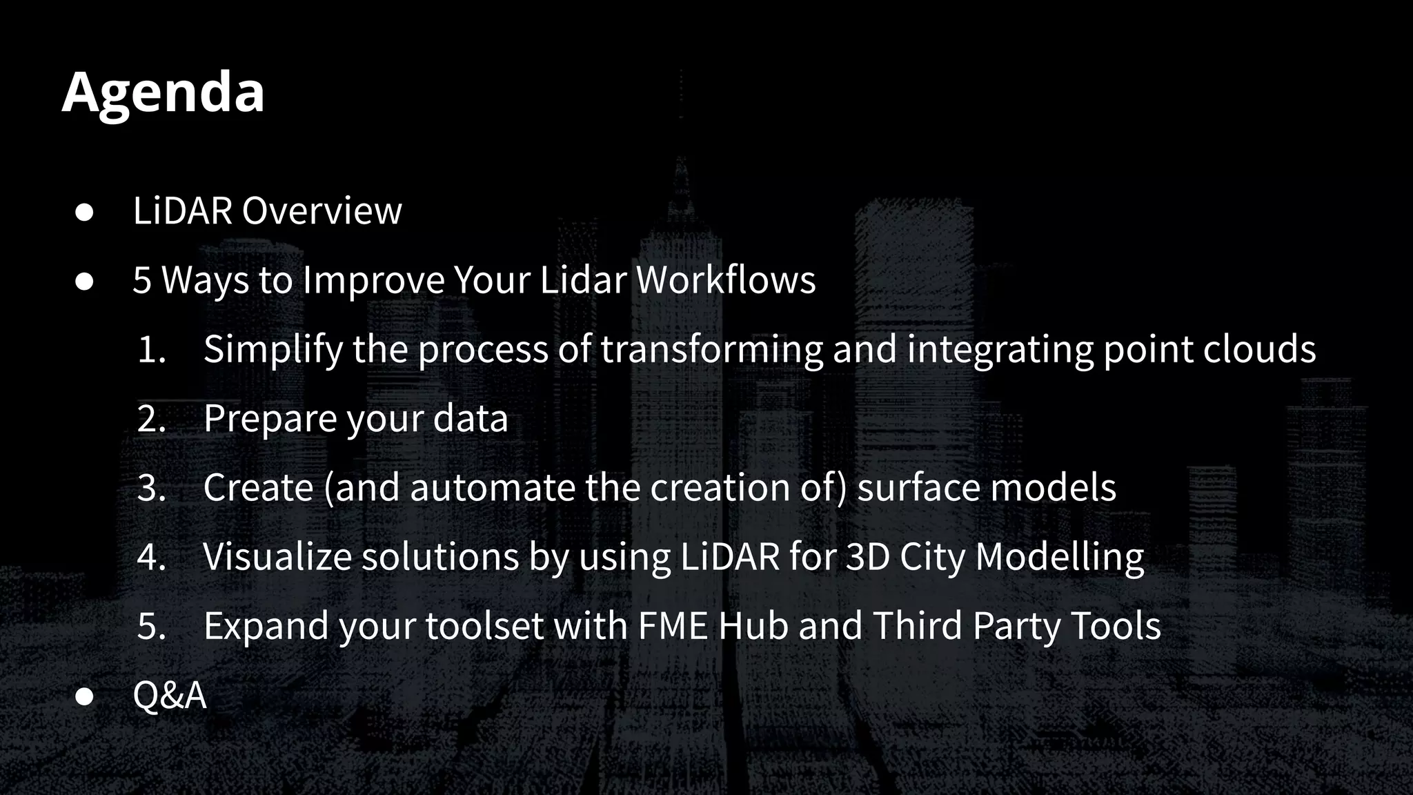
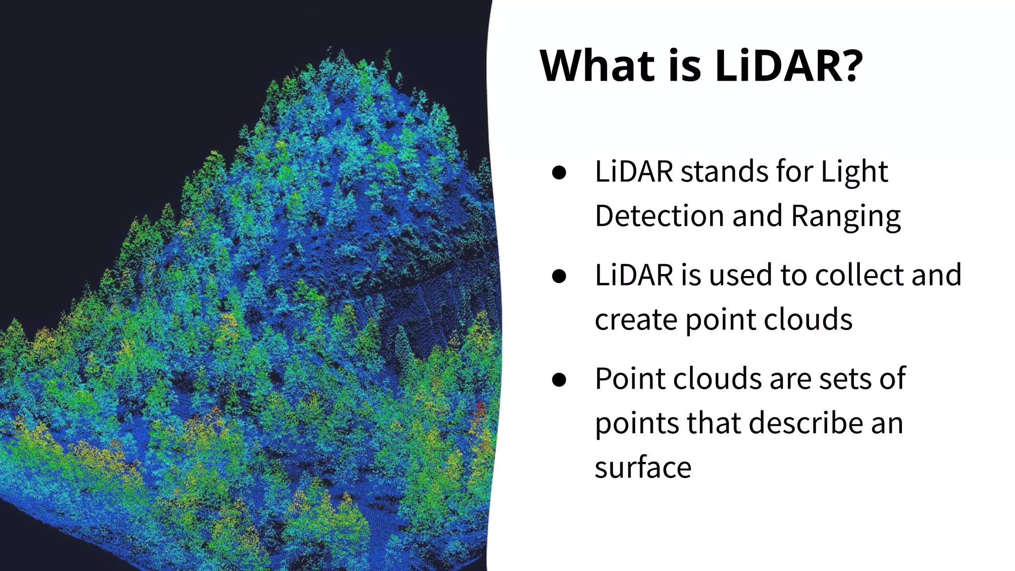
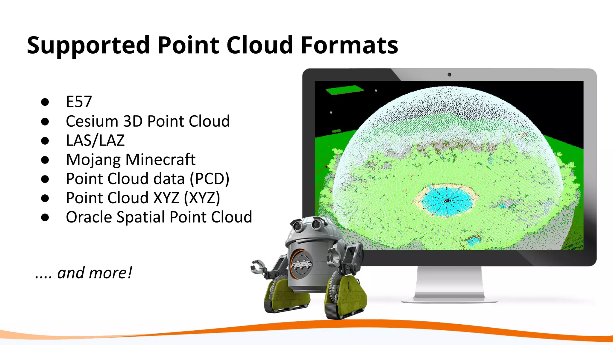
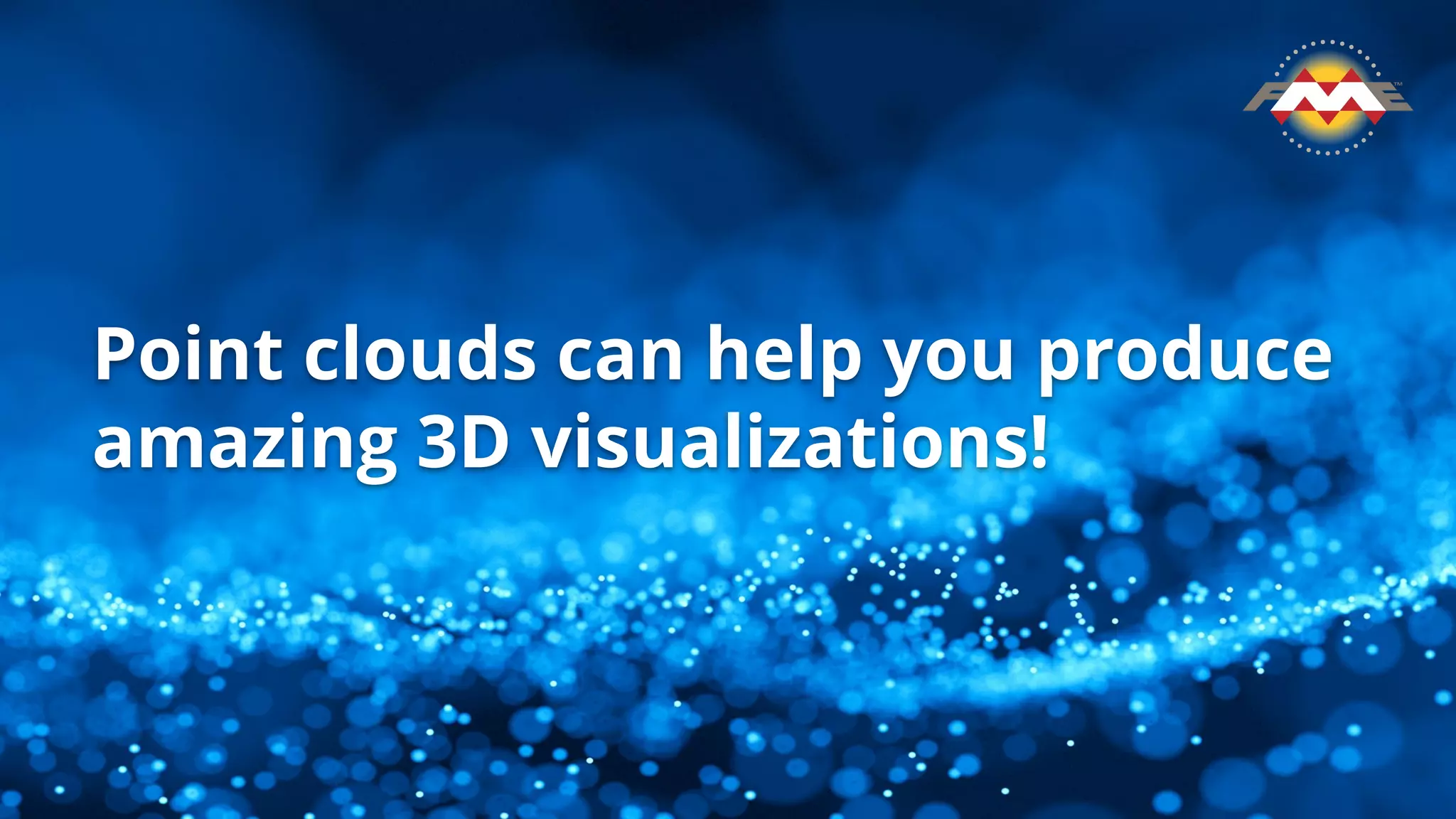
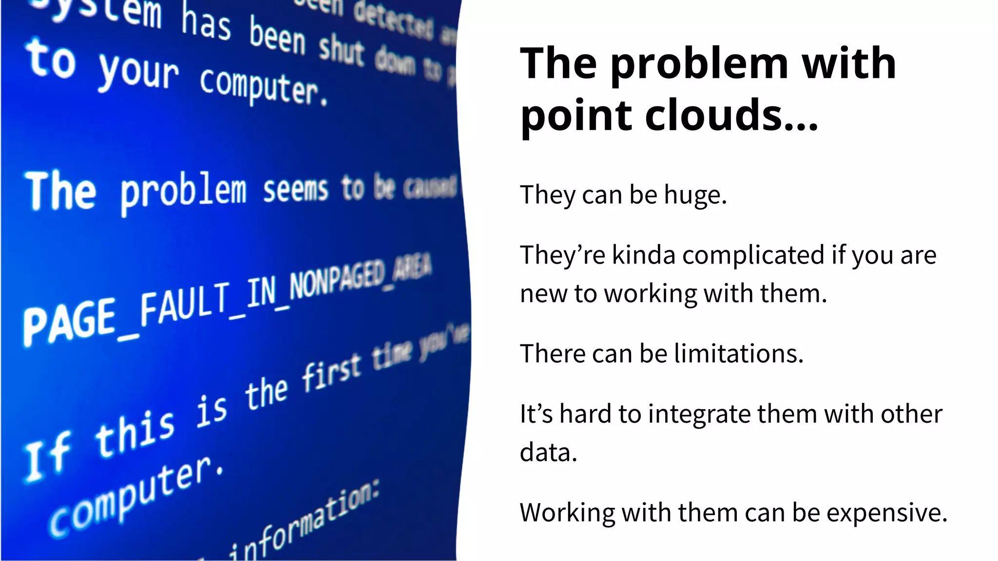
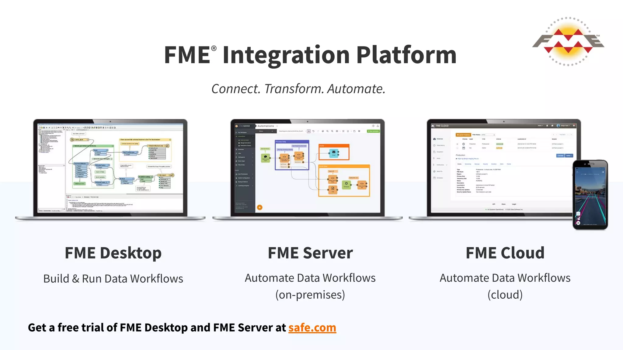
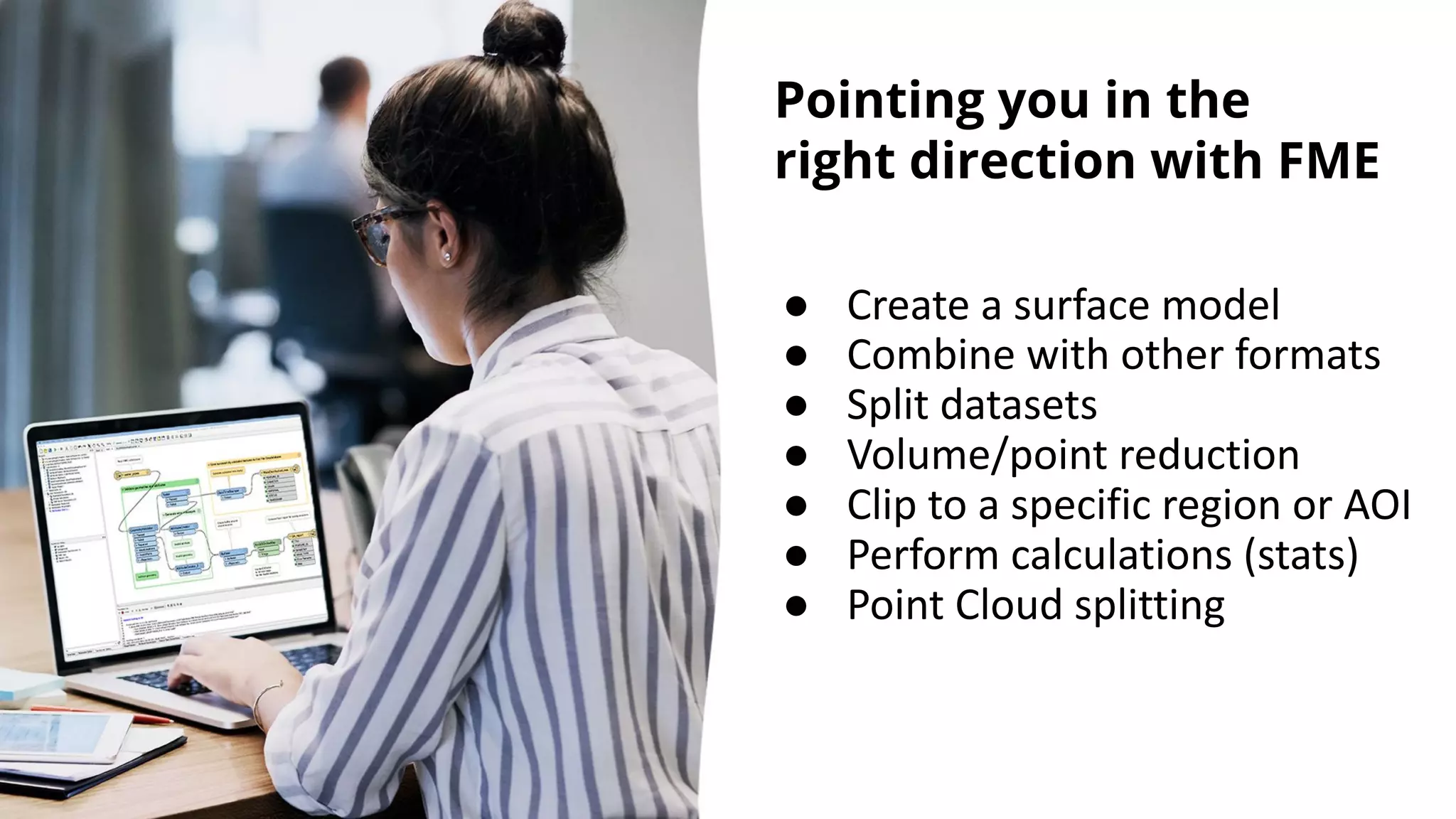
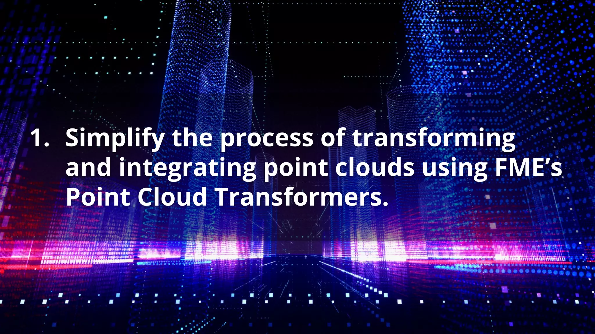
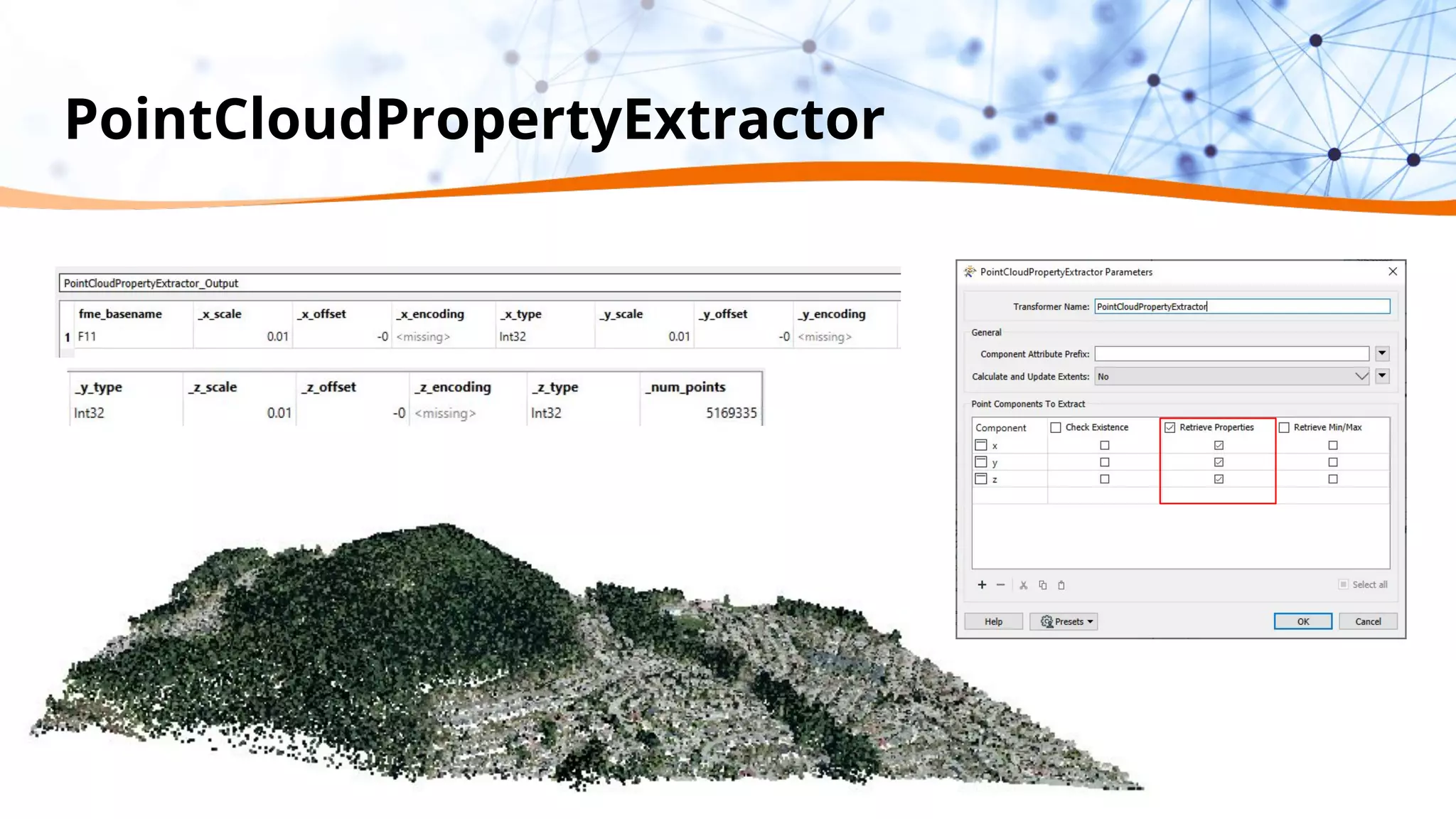
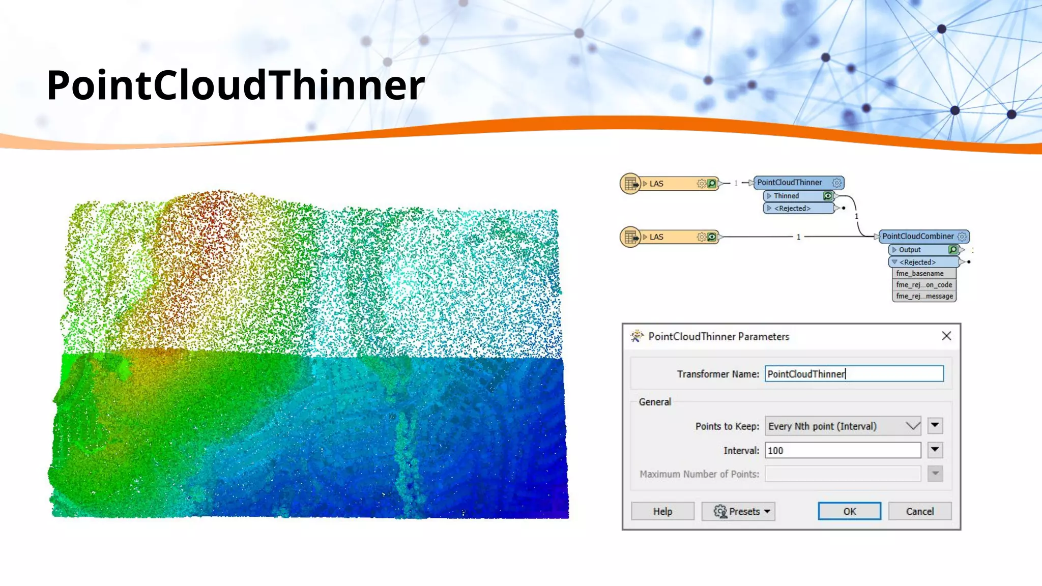
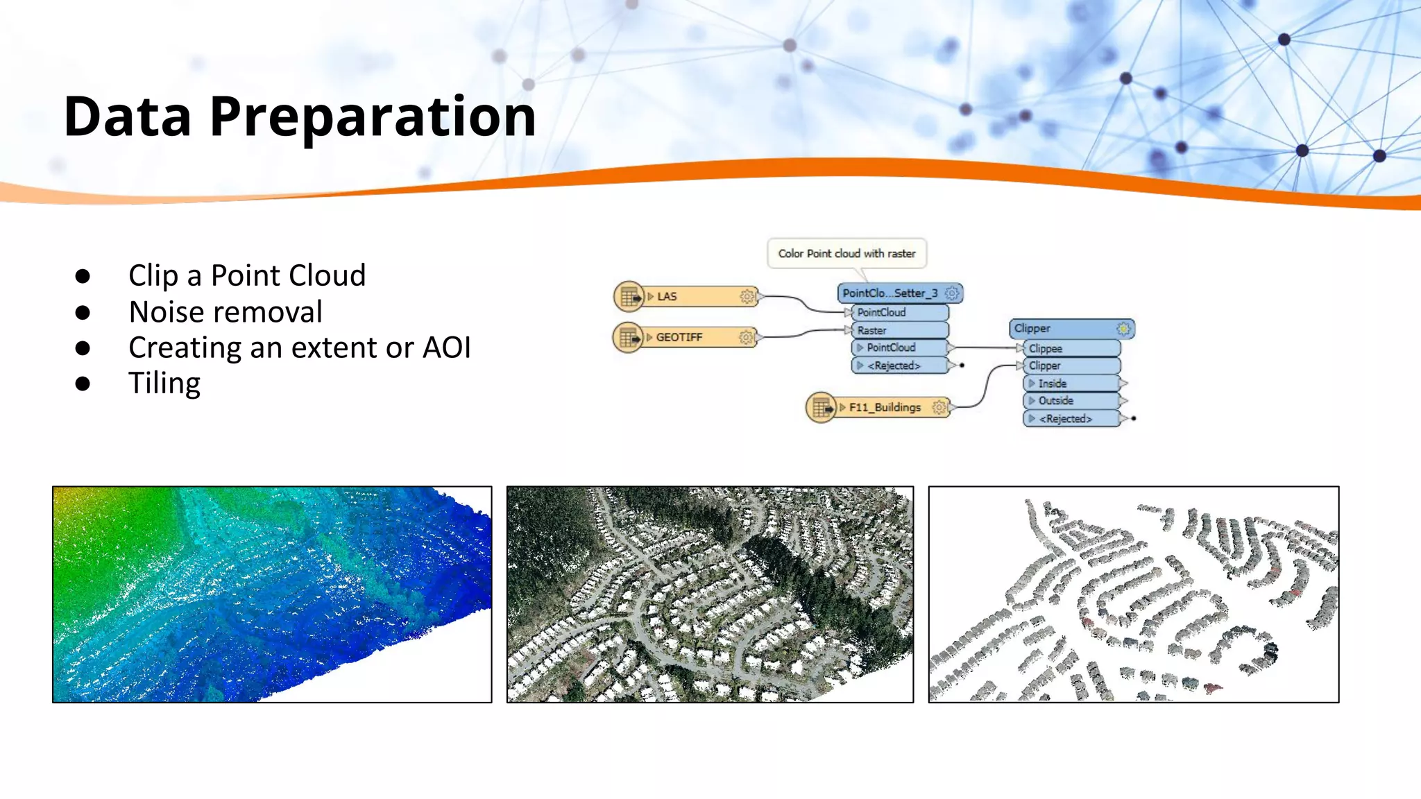
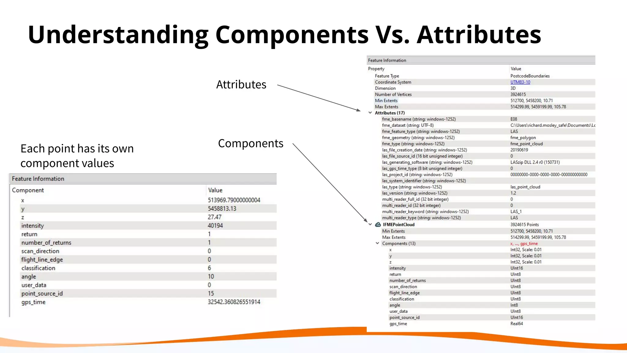
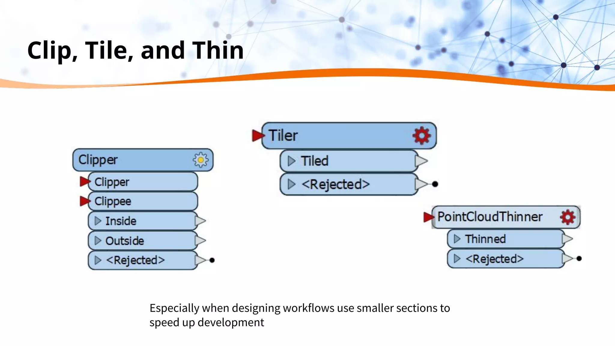
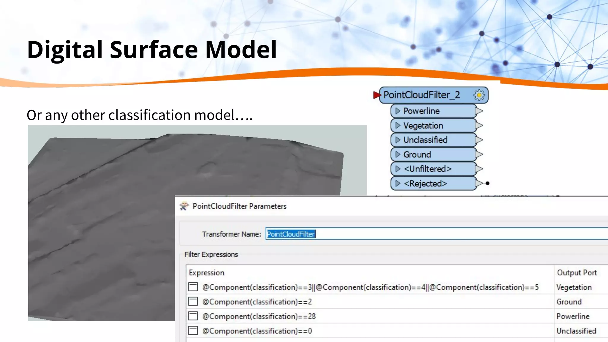
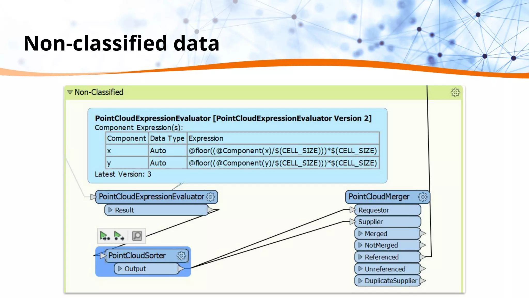
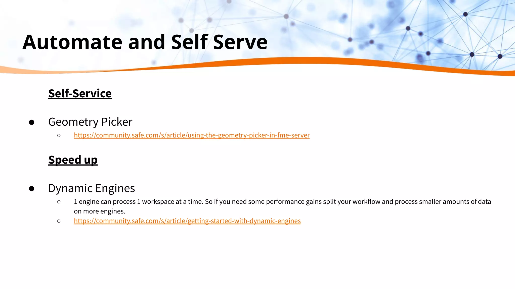
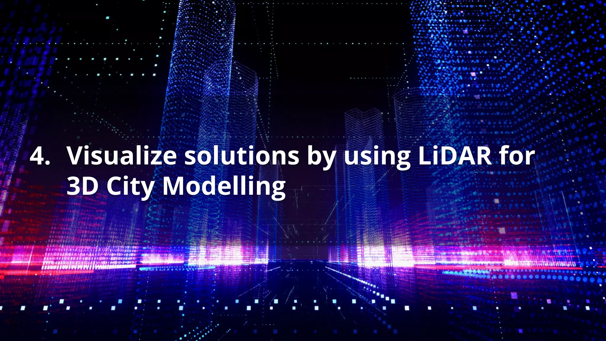
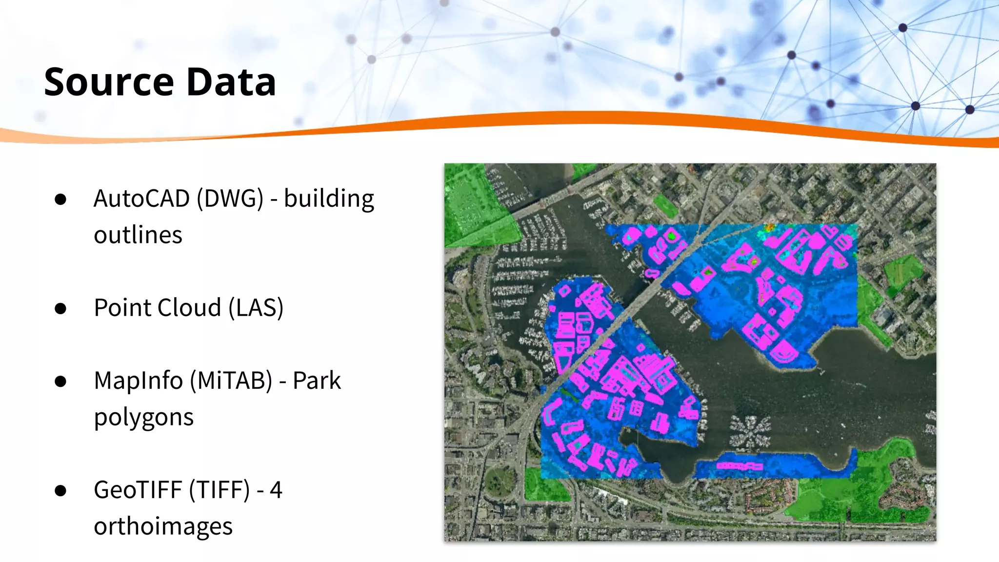
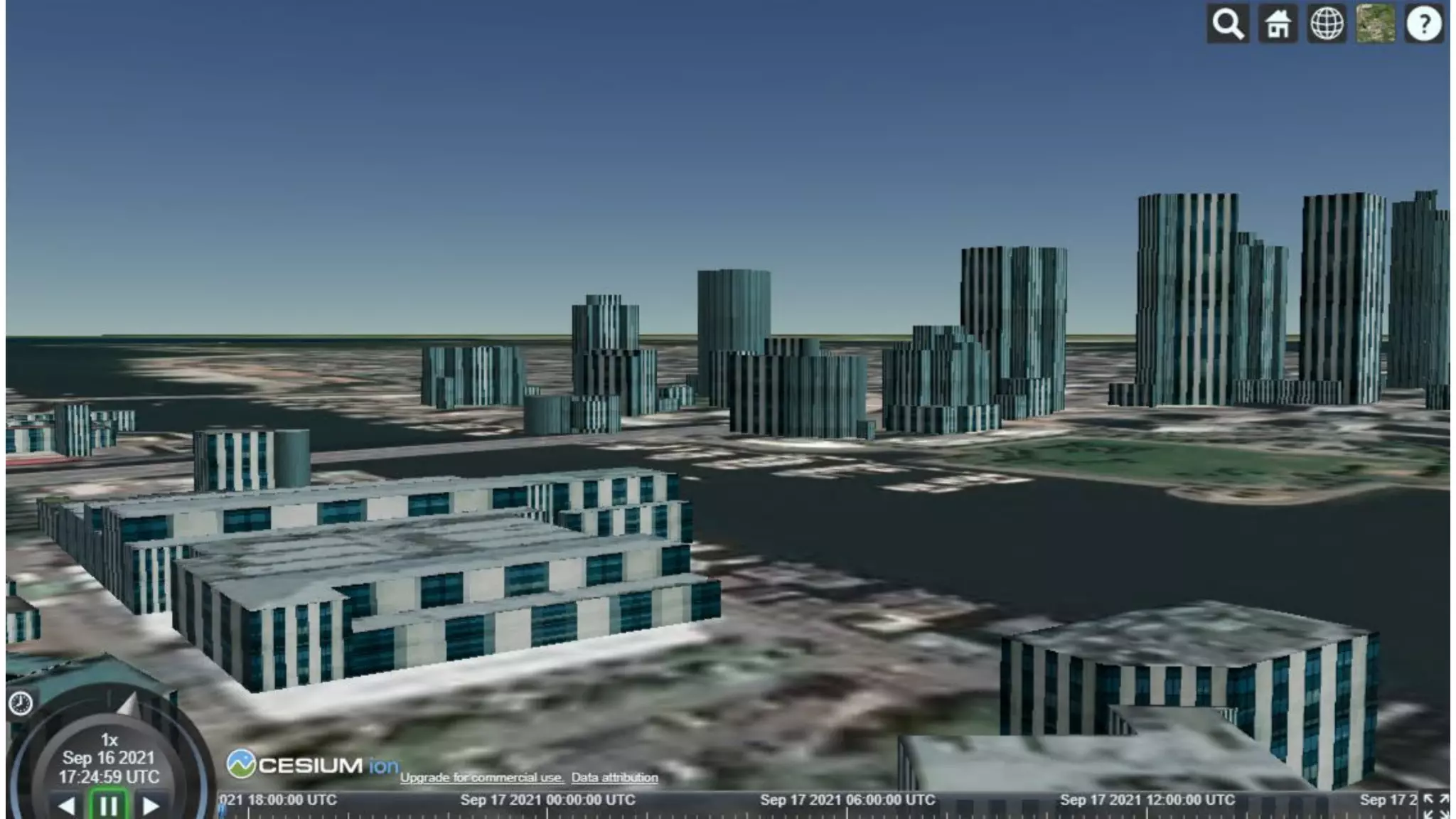
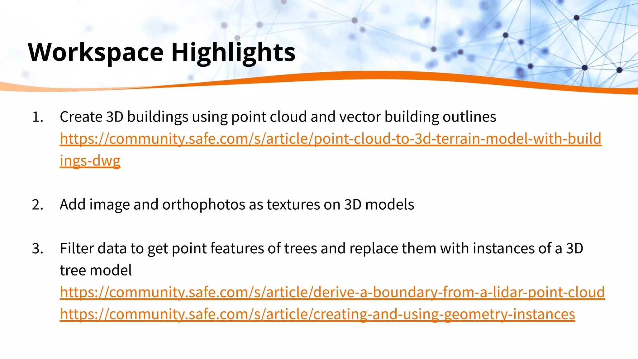
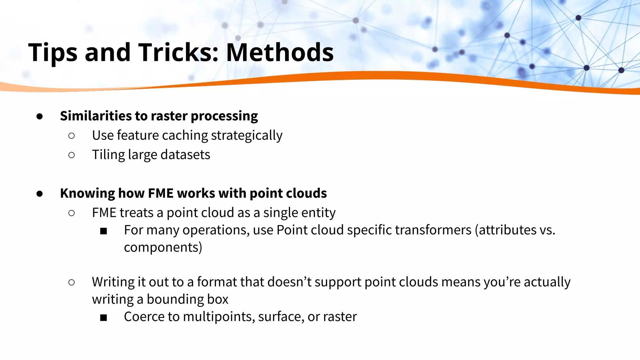
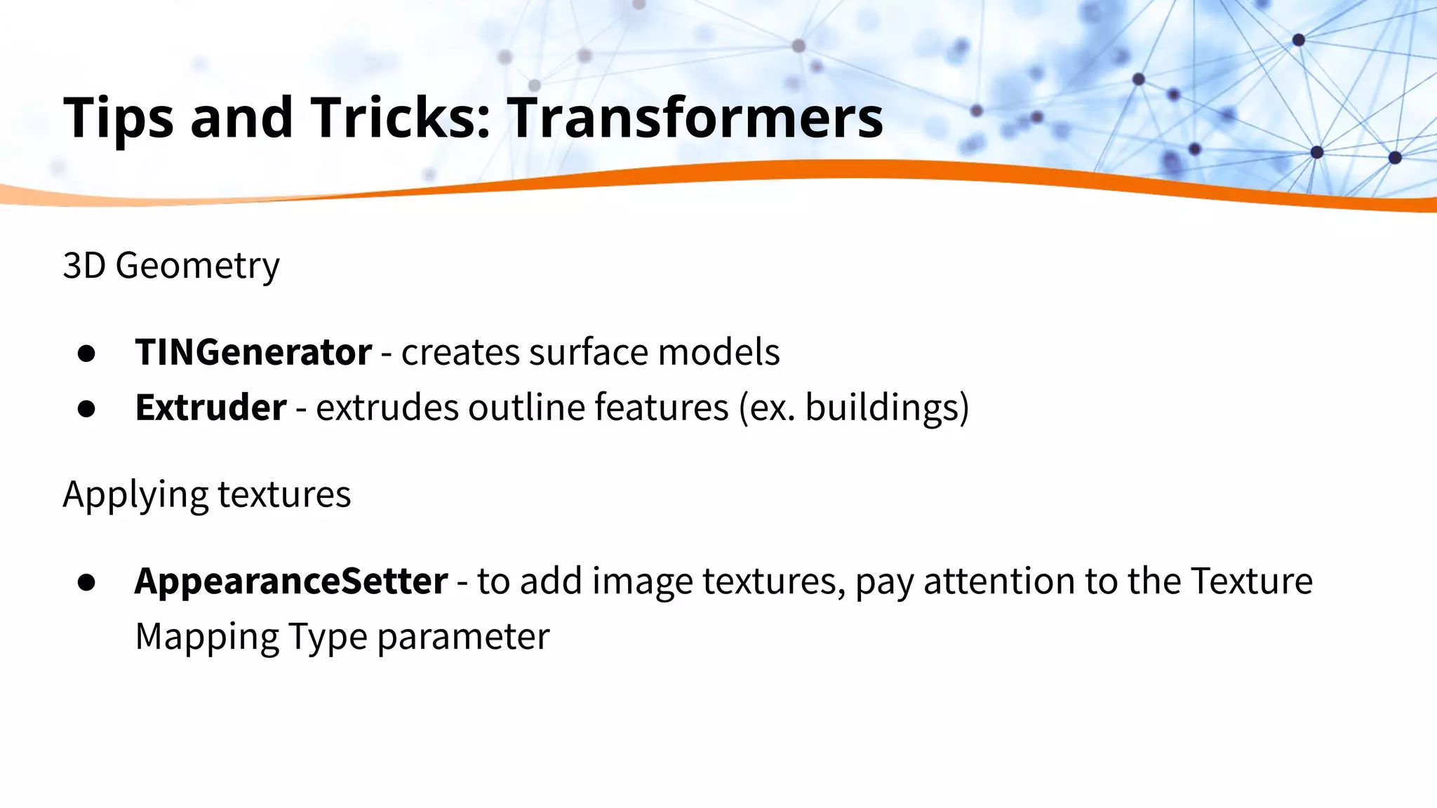
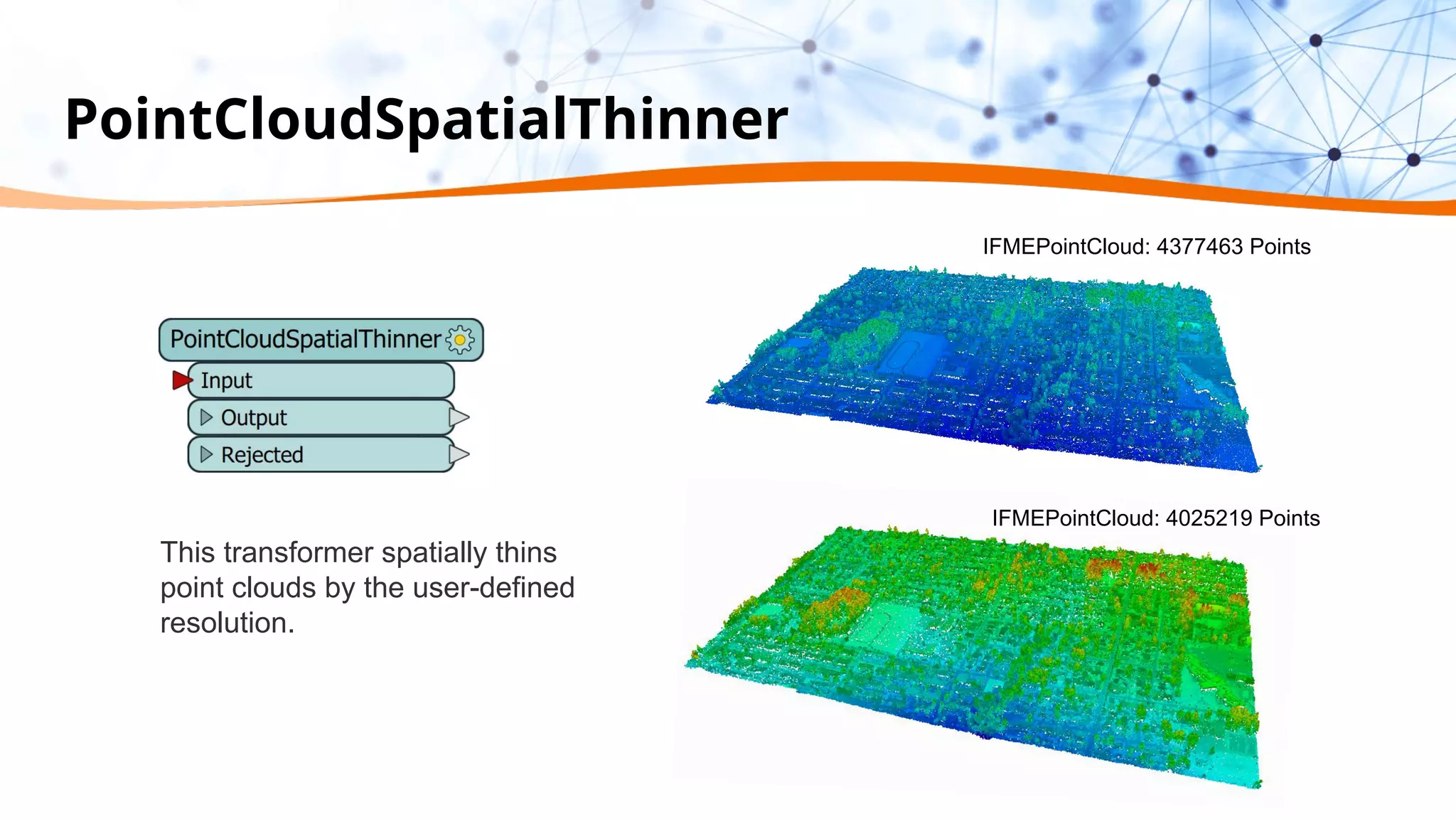
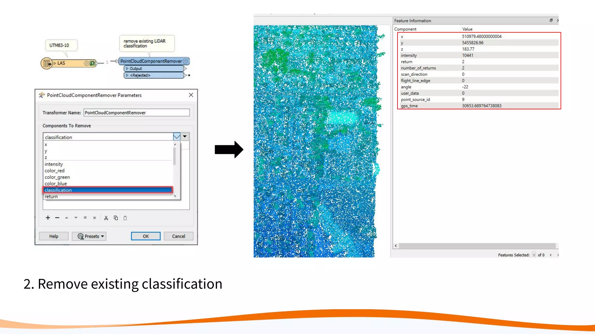
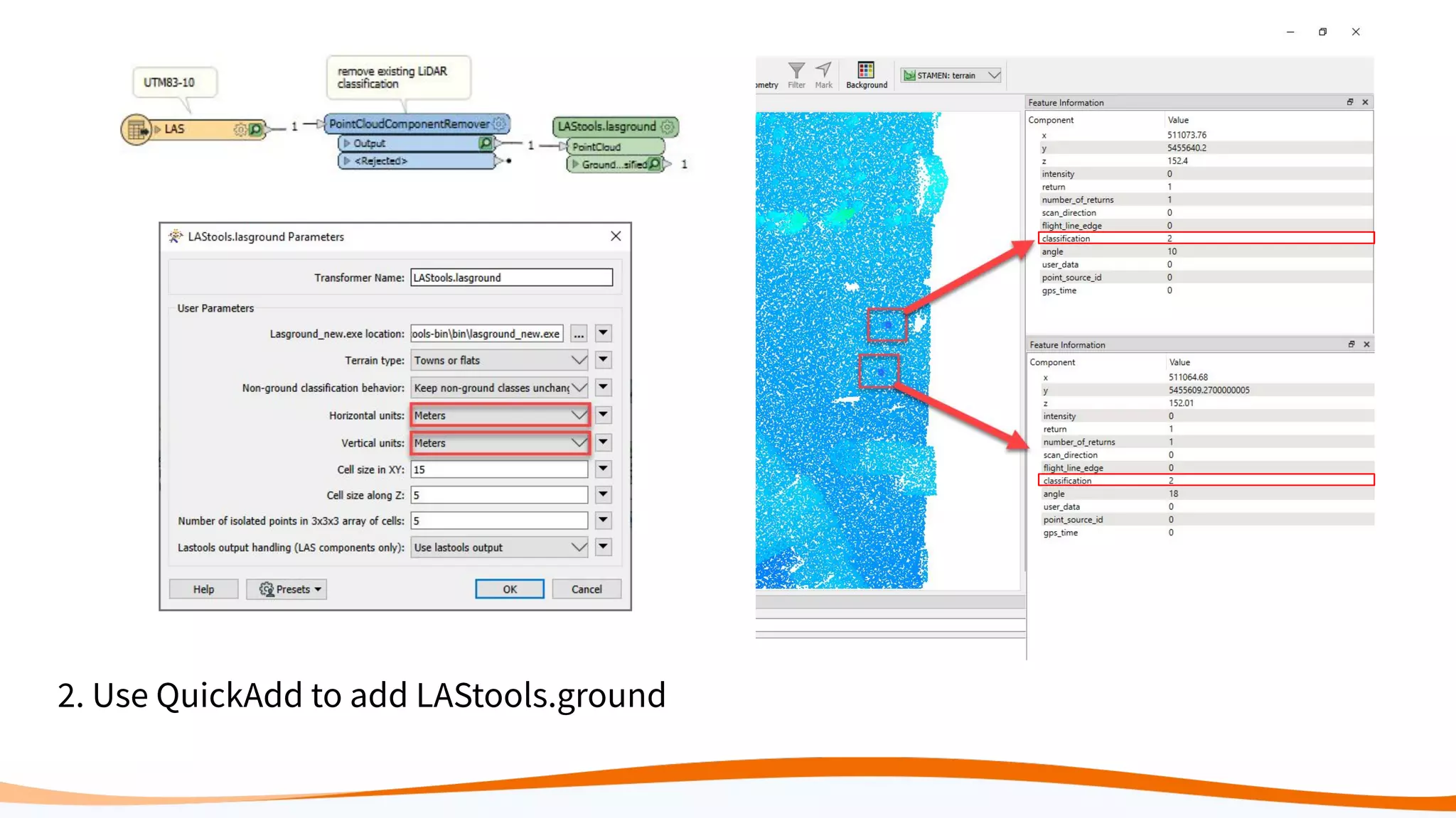
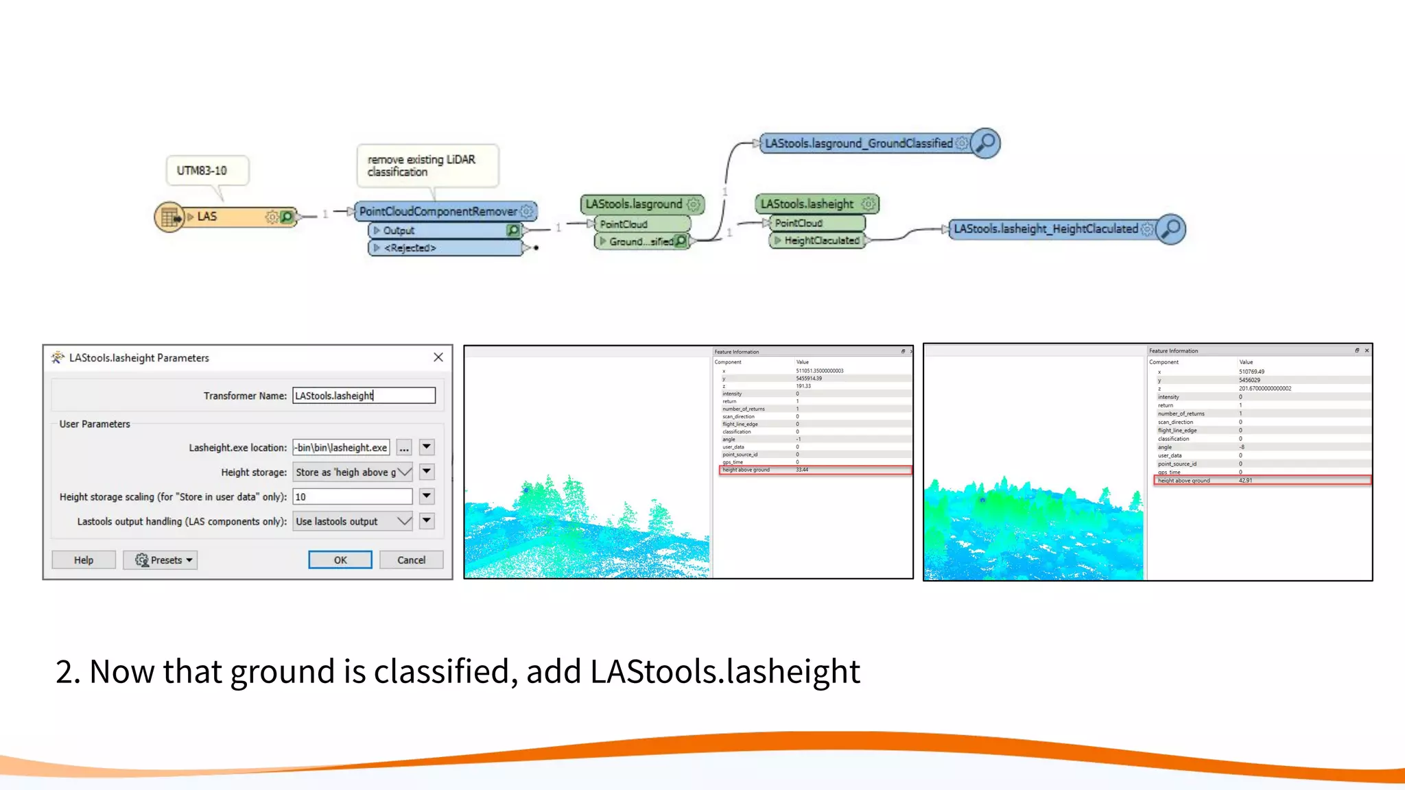
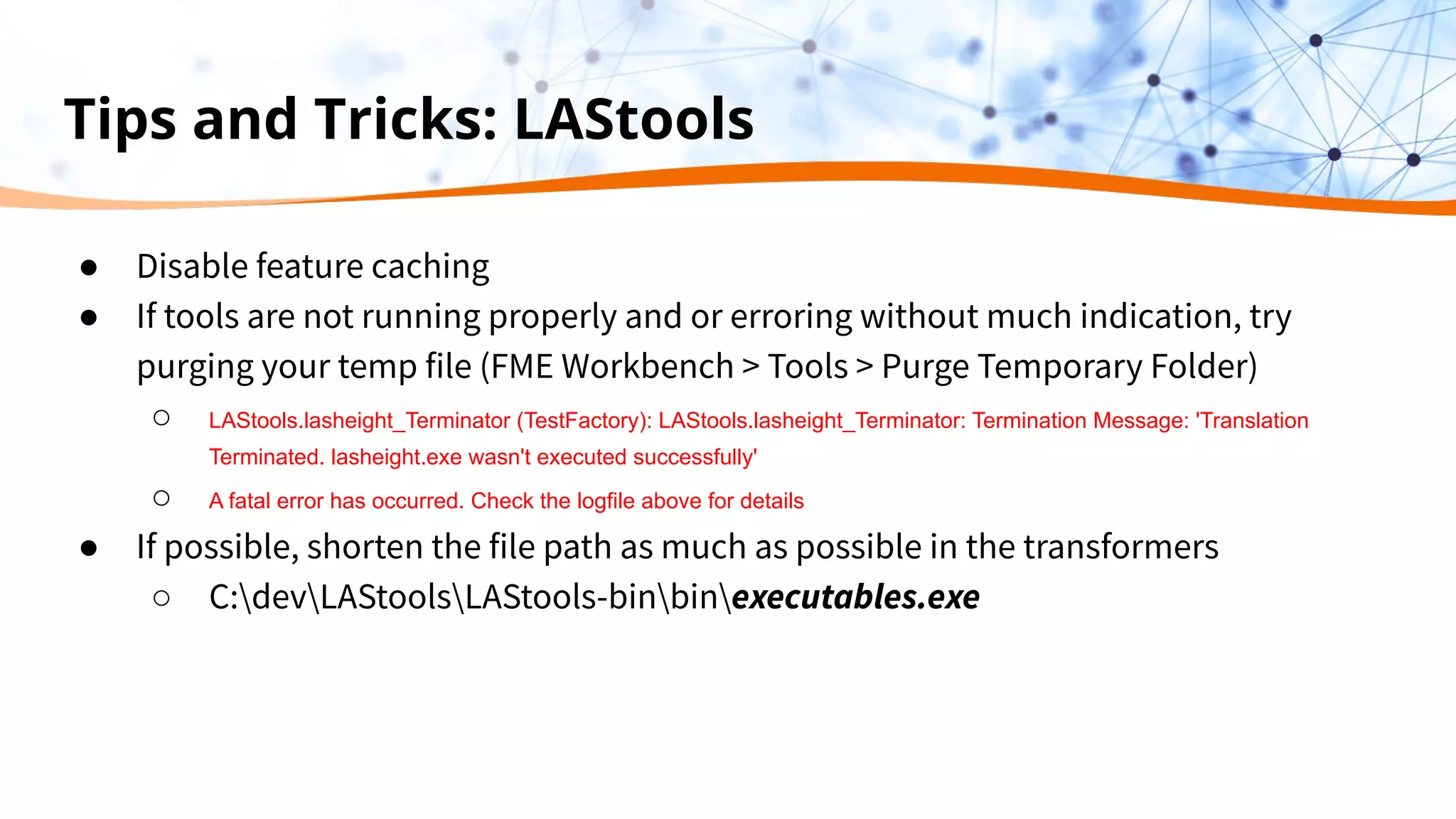
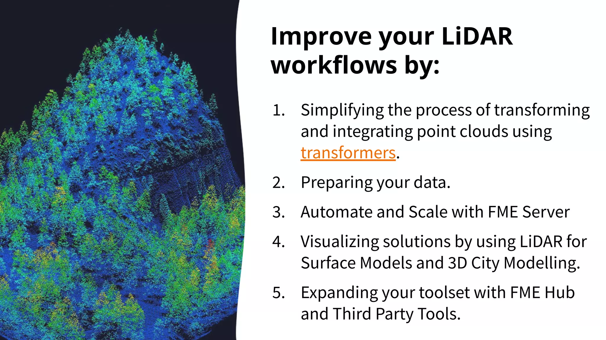
This document discusses 5 ways to improve LiDAR workflows using FME software. It begins with an overview of LiDAR and point clouds before addressing each of the 5 ways: 1) simplifying point cloud transformations with FME transformers, 2) preparing data, 3) automating surface model creation, 4) visualizing solutions through 3D city modeling, and 5) expanding tools with FME Hub and third party tools like LAStools. The presentation concludes by emphasizing how FME can help simplify and scale LiDAR workflows.
ArcMap is ArcGIS’s desktop application for all map-based tasks, like data
and map analysis, editing and production of maps. In ArcMap, a user can
display data, make selections, analyse data, manipulate data, create data,
assign symbols and produce maps. ArcMap also serves as gateway to a
number of software extensions that perform specific tasks and analyses (extensions will be discussed later in the course).
Linear Referencing (LRS): How FME Measures UpSafe Software
Unleash FME's hidden potential for Linear Referencing System (LRS) workflows. Learn how to work with FME's LRS tools to support your measures, events and route geometries.
You'll also see how FME can switch between LRS datasets and a segmented LRS model, to allow others to view the data in more traditional GIS platforms. Plus, hear how Bo Guo of GISTEC is helping his customers use FME to solve their LRS problems.
Understanding Coordinate Systems and Projections for ArcGISJohn Schaeffer
Everything you need to know to work with coordinate systems and projecting data in ArcGIS. The presentation starts by explaining the terminology, and then discusses the details you need to know to actually work successfully with coordinate systems, use the proper projections, and geographic transformations. This is a very practical look at a complex subject.
As the large effort of a program, issues of conflict resolution, communication, benefit and change management are some of the main reasons program and project fails to delivery their outcomes.
The program governance integrates with the benefits management domain to help ensure that the program is continuously aligned with organizational strategy and that the intended value can still be achieved by the delivery of program benefits.
Balancing the elements of a program – strategic alignment, governance, stakeholder and benefit management - is the program manager's job.
In this presentation the attendees will have the satisfaction to see a real case framework to approach a program management so as to improve the delivery of intended benefits by setting-up a Project governance, stakeholder management, benefit and change management through a framework within which project decisions are made to improve program and project performances.
Presentation: This presentation gives a brief introduction to tools in ArcGIS and was designed for the Surface Water Quality Monitoring (SWQM) GIS training hosted by Texas Commission on Environmental Quality (TCEQ) staff.
Training: The goal of the SWQM GIS training course is to introduce beginner and intermediate GIS users within the TCEQ surface water monitoring network to the geospatial software, skills, analyses, and data most often used by water resource professionals. The training features presentations from a range of GIS experts from TCEQ, TPWD, and other organizations.
More information on the training: https://www.tceq.texas.gov/waterquality/monitoring/training
SAR is a type of radar which works with antenna and receiver using radio waves which can create two dimension or three dimension of the objects . A synthetic-aperture radar is an imaging radar mounted on a moving platform. SAR gives high resolution data and works 24*7.
LiDAR (“Light Detection and Ranging”) is a method of remote sensing that uses light to measure ranges. LiDAR systems generate many component measurements that result in valuable spatial data.
All of this information results in massive files that are bursting with potential, but limited in use by their size and complexity.
In this webinar, learn how data integration techniques can help you get the most out of LiDAR and point cloud data. We’ll cover how to:
- Quickly process point clouds and integrate them with other data sources
- Use LiDAR for 3D city modelling
- Make a digital terrain and surface model from a point cloud
- Integrate programs like LAStools into your workflows
By applying data integration automation, you save time, reduce manual effort, and ensure you get the most out of your LiDAR data.
Maximize the possibilities of your LiDAR data with FME. Through demos, you’ll learn how to extract the full value of point clouds by quickly processing and combining them with other data sources. We’ll also show you real-world examples using LiDAR for 3D city modelling & viewshed analysis, with specific takeaways that can be applied to your own data. Plus, find out how to integrate command-line programs like LAStools into your FME workflow.
ArcGIS Data Interoperability: Tips for LiDAR, 3D, and BIMSafe Software
Discover how to master 3D data and ArcGIS using the Data Interoperability extension. Learn more about transforming LiDAR point clouds, creating 3D buildings from 2D geometries, and converting BIM data formats in ArcGIS for optimal visualization and analysis.
What is Distributed Computing, Why we use Apache SparkAndy Petrella
In this talk we introduce the notion of distributed computing then we tackle the Spark advantages.
The Spark core content is very tiny because the whole explanation has been done live using a Spark Notebook (https://github.com/andypetrella/spark-notebook/blob/geek/conf/notebooks/Geek.snb).
This talk has been given together by @xtordoir and myself at the University of Liège, Belgium.
Mastering MicroStation DGN: How to Integrate CAD and GISSafe Software
Dive deep into the world of CAD-GIS integration with our expert-led webinar. Discover how to seamlessly transfer data between Bentley MicroStation and leading GIS platforms, such as Esri ArcGIS. This session goes beyond mere CAD/GIS conversion, showcasing techniques to precisely transform MicroStation elements including cells, text, lines, and symbology. We’ll walk you through tags versus item types, and understanding how to leverage both. You’ll also learn how to reproject to any coordinate system. Finally, explore cutting-edge automated methods for managing database links, and delve into innovative strategies for enabling self-serve data collection and validation services.
Join us to overcome the common hurdles in CAD and GIS integration and enhance the efficiency of your workflows. This session is perfect for professionals, both new to FME and seasoned users, seeking to streamline their processes and leverage the full potential of their CAD and GIS systems.
Bridging Between CAD & GIS: 8 Ways to Automate Your Data IntegrationSafe Software
Converting between CAD and GIS is a common requirement for projects involving infrastructure, buildings, city plans, and more. Unfortunately, the workflow presents many challenges, like translating geometry, attributes, annotations, symbology, geolocation, and other elements.
So how do you allow data to flow freely between these disparate data types, without losing the precision offered by CAD and the spatial context offered by GIS?
This webinar will explore the power of automated data integration workflows for CAD and GIS.
First, we’ll discuss challenges and scenarios for CAD-to-GIS translations, and demo how to use FME to power a digital plan submission portal that validates CAD data and integrates it into the central GIS repository. Next, we’ll discuss challenges and scenarios for GIS-to-CAD conversions, and demo how to build an automated FME workflow for requesting CAD data from GIS.
At the end of the webinar, you'll know how to achieve harmony between CAD & GIS by automating its integration.
Bridging Between CAD & GIS: 8 Ways to Automate Data IntegrationSafe Software
Converting between CAD and GIS is a common requirement for projects involving infrastructure, buildings, city plans, and more. Unfortunately, the workflow presents many challenges, like translating geometry, attributes, annotations, symbology, geolocation, and other elements.
So how do you allow data to flow freely between these disparate data types, without losing the precision offered by CAD and the spatial context offered by GIS?
This webinar will explore the power of automated data integration workflows for CAD and GIS.
First, we’ll discuss challenges and scenarios for CAD-to-GIS translations, and demo how to use FME to power a digital plan submission portal that validates CAD data and integrates it into the central GIS repository. Next, we’ll discuss challenges and scenarios for GIS-to-CAD conversions, and demo how to build an automated FME workflow for requesting CAD data from GIS.
At the end of the webinar, you'll know how to achieve harmony between CAD & GIS by automating its integration.
Gain Total Control of Your LiDAR and Point Cloud DataSafe Software
Learn how to quickly transform LiDAR data to meet your requirements with FME. You'll discover how to easily clip, tile, split and otherwise manipulate point clouds using automated processes capable of transforming millions of points in seconds. Plus with FME's support for 300+ formats -- including LAS, Oracle Point Cloud, and RIEGL -- you'll see how to integrate LiDAR with GIS, CAD, and raster data. New for FME 2013, we'll share how you can perform point-by-point calculations and subsequently filter those points based on color, intensity, and other criteria.
Let's integrate CAD/BIM/GIS on the same platform: A practical approach in rea...SANGHEE SHIN
I gave this keynote talk at 3D GeoInfo conference held at Singapore on 25th September 2019. I shared my experiences in integrating CAD/BIM/GIS on the web platform and introduced mago3D from the technical point of view.
Bridging Between CAD & GIS: 8 Ways to Automate Data IntegrationSafe Software
Converting between CAD and GIS is a common requirement for projects involving infrastructure, buildings, city plans, and more. Unfortunately, the workflow presents many challenges, like translating geometry, attributes, annotations, symbology, geolocation, and other elements.
So how do you allow data to flow freely between these disparate data types, without losing the precision offered by CAD and the spatial context offered by GIS?
This webinar will explore the power of automated data integration workflows for CAD and GIS.
First, we’ll discuss challenges and scenarios for CAD-to-GIS translations, and demo how to use FME to power a digital plan submission portal that validates CAD data and integrates it into the central GIS repository. Next, we’ll discuss challenges and scenarios for GIS-to-CAD conversions, and demo how to build an automated FME workflow for requesting CAD data from GIS.
At the end of the webinar, you'll know how to achieve harmony between CAD & GIS by automating its integration.
Cloud Frontiers: A Deep Dive into Serverless Spatial Data and FMESafe Software
Following the popularity of “Cloud Revolution: Exploring the New Wave of Serverless Spatial Data,” we’re thrilled to announce this much-anticipated encore webinar.
In this sequel, we’ll dive deeper into the Cloud-Native realm by uncovering practical applications and FME support for these new formats, including COGs, COPC, FlatGeoBuf, GeoParquet, STAC, and ZARR.
Building on the foundation laid by industry leaders Michelle Roby of Radiant Earth and Chris Holmes of Planet in the first webinar, this second part offers an in-depth look at the real-world application and behind-the-scenes dynamics of these cutting-edge formats. We will spotlight specific use-cases and workflows, showcasing their efficiency and relevance in practical scenarios.
Discover the vast possibilities each format holds, highlighted through detailed discussions and demonstrations. Our expert speakers will dissect the key aspects and provide critical takeaways for effective use, ensuring attendees leave with a thorough understanding of how to apply these formats in their own projects.
Elevate your understanding of how FME supports these cutting-edge technologies, enhancing your ability to manage, share, and analyze spatial data. Whether you’re building on knowledge from our initial session or are new to the serverless spatial data landscape, this webinar is your gateway to mastering cloud-native formats in your workflows.
SCALABLE MONITORING USING PROMETHEUS WITH APACHE SPARKzmhassan
As spark applications move to a containerized environment, there are many questions about how to best configure server systems in the container world. In this talk we will demonstrate a set of tools to better monitor performance and identify optimal configuration settings. We will demonstrate how Prometheus, a project that is now part of the Cloud Native Computing Foundation (CNCF), can be applied to monitor and archive system performance data in a containerized spark environment. In our examples, we will gather spark metric output through Prometheus and present the data with Grafana dashboards. We will use our examples to demonstrate how performance can be enhanced through different tuned configuration settings. Our demo will show how to configure settings across the cluster as well as within each node.
Integrating data has never been so relaxing with FME 2020.0. Join this webinar to see workbench improvements, new connectors and formats, Revit support enhancements, the PicterraConnector, FME AR and more.
This is the first webinar in a 2-part series. Part 2: "FME 2020 Unleashed: Automating" https://www.safe.com/webinars/fme-2020-unleashed-automating/
As more workloads move to severless-like environments, the importance of properly handling downscaling increases. While recomputing the entire RDD makes sense for dealing with machine failure, if your nodes are more being removed frequently, you can end up in a seemingly loop-like scenario, where you scale down and need to recompute the expensive part of your computation, scale back up, and then need to scale back down again.
Even if you aren’t in a serverless-like environment, preemptable or spot instances can encounter similar issues with large decreases in workers, potentially triggering large recomputes. In this talk, we explore approaches for improving the scale-down experience on open source cluster managers, such as Yarn and Kubernetes-everything from how to schedule jobs to location of blocks and their impact (shuffle and otherwise).
Bridging Between CAD & GIS: 6 Ways to Automate Your Data IntegrationSafe Software
Converting between CAD and GIS is a common requirement for projects involving infrastructure, buildings, city plans, and more. Unfortunately, the workflow presents many challenges, like translating geometry, attributes, annotations, symbology, geolocation, and other elements.
So how do you allow data to flow freely between these disparate data types, without losing the precision offered by CAD and the spatial context offered by GIS?
This webinar will explore the power of automated data integration workflows for CAD and GIS.
First, we’ll discuss challenges and scenarios for CAD-to-GIS translations, and demo how to use FME to power a digital plan submission portal that validates CAD data and integrates it into the central GIS repository. Next, we’ll discuss challenges and scenarios for GIS-to-CAD conversions, and demo how to build an automated FME workflow for requesting CAD data from GIS.
At the end of the webinar, you'll know how to achieve harmony between CAD & GIS by automating its integration.
Bridging Between CAD & GIS: 6 Ways to Automate Your Data Integrationmarketing932765
Converting between CAD and GIS is a common requirement for projects involving infrastructure, buildings, city plans, and more. Unfortunately, the workflow presents many challenges, like translating geometry, attributes, annotations, symbology, geolocation, and other elements.
So how do you allow data to flow freely between these disparate data types, without losing the precision offered by CAD and the spatial context offered by GIS?
This webinar will explore the power of automated data integration workflows for CAD and GIS.
First, we’ll discuss challenges and scenarios for CAD-to-GIS translations, and demo how to use FME to power a digital plan submission portal that validates CAD data and integrates it into the central GIS repository. Next, we’ll discuss challenges and scenarios for GIS-to-CAD conversions, and demo how to build an automated FME workflow for requesting CAD data from GIS.
At the end of the webinar, you'll know how to achieve harmony between CAD &GIS by automating its integration.
Similar to 5 Ways to Improve Your LiDAR Workflows (20)
Essentials of Automations: The Art of Triggers and Actions in FMESafe Software
In this second installment of our Essentials of Automations webinar series, we’ll explore the landscape of triggers and actions, guiding you through the nuances of authoring and adapting workspaces for seamless automations. Gain an understanding of the full spectrum of triggers and actions available in FME, empowering you to enhance your workspaces for efficient automation.
We’ll kick things off by showcasing the most commonly used event-based triggers, introducing you to various automation workflows like manual triggers, schedules, directory watchers, and more. Plus, see how these elements play out in real scenarios.
Whether you’re tweaking your current setup or building from the ground up, this session will arm you with the tools and insights needed to transform your FME usage into a powerhouse of productivity. Join us to discover effective strategies that simplify complex processes, enhancing your productivity and transforming your data management practices with FME. Let’s turn complexity into clarity and make your workspaces work wonders!
Essentials of Automations: Optimizing FME Workflows with ParametersSafe Software
Are you looking to streamline your workflows and boost your projects’ efficiency? Do you find yourself searching for ways to add flexibility and control over your FME workflows? If so, you’re in the right place.
Join us for an insightful dive into the world of FME parameters, a critical element in optimizing workflow efficiency. This webinar marks the beginning of our three-part “Essentials of Automation” series. This first webinar is designed to equip you with the knowledge and skills to utilize parameters effectively: enhancing the flexibility, maintainability, and user control of your FME projects.
Here’s what you’ll gain:
- Essentials of FME Parameters: Understand the pivotal role of parameters, including Reader/Writer, Transformer, User, and FME Flow categories. Discover how they are the key to unlocking automation and optimization within your workflows.
- Practical Applications in FME Form: Delve into key user parameter types including choice, connections, and file URLs. Allow users to control how a workflow runs, making your workflows more reusable. Learn to import values and deliver the best user experience for your workflows while enhancing accuracy.
- Optimization Strategies in FME Flow: Explore the creation and strategic deployment of parameters in FME Flow, including the use of deployment and geometry parameters, to maximize workflow efficiency.
- Pro Tips for Success: Gain insights on parameterizing connections and leveraging new features like Conditional Visibility for clarity and simplicity.
We’ll wrap up with a glimpse into future webinars, followed by a Q&A session to address your specific questions surrounding this topic.
Don’t miss this opportunity to elevate your FME expertise and drive your projects to new heights of efficiency.
The Zero-ETL Approach: Enhancing Data Agility and InsightSafe Software
In the ever-evolving landscape of data management, Zero-ETL is an approach that is reshaping how businesses handle and integrate their data. This webinar explores Zero-ETL, a paradigm shift from the traditional Extract, Transform, Load (ETL) process, offering a more streamlined, efficient, and real-time data integration method.
We will begin with an introduction to the concept of Zero-ETL, including how it allows direct access to data in its native environment and real-time data transformation, providing up-to-date information with significantly reduced data redundancy.
Next, we'll take you through several demonstrations showing how Zero-ETL can deliver real-time data and enable the free movement of data between systems. We will also discuss the various tools that support all aspects of Zero-ETL, providing attendees with an understanding of how they can adopt this innovative approach in their organizations.
Lastly, the session will conclude with an interactive Q&A segment, allowing participants to gain deeper insights into how Zero-ETL can be tailored to their specific business needs and how they can get started today.
Join us to discover how Zero-ETL can elevate your organization's data strategy.
Cloud Frontiers: A Deep Dive into Serverless Spatial Data and FMESafe Software
Following the popularity of "Cloud Revolution: Exploring the New Wave of Serverless Spatial Data," we're thrilled to announce this much-anticipated encore webinar.
In this sequel, we'll dive deeper into the Cloud-Native realm by uncovering practical applications and FME support for these new formats, including COGs, COPC, FlatGeoBuf, GeoParquet, STAC, and ZARR.
Building on the foundation laid by industry leaders Michelle Roby of Radiant Earth and Chris Holmes of Planet in the first webinar, this second part offers an in-depth look at the real-world application and behind-the-scenes dynamics of these cutting-edge formats. We will spotlight specific use-cases and workflows, showcasing their efficiency and relevance in practical scenarios.
Discover the vast possibilities each format holds, highlighted through detailed discussions and demonstrations. Our expert speakers will dissect the key aspects and provide critical takeaways for effective use, ensuring attendees leave with a thorough understanding of how to apply these formats in their own projects.
Elevate your understanding of how FME supports these cutting-edge technologies, enhancing your ability to manage, share, and analyze spatial data. Whether you're building on knowledge from our initial session or are new to the serverless spatial data landscape, this webinar is your gateway to mastering cloud-native formats in your workflows.
From Event to Action: Accelerate Your Decision Making with Real-Time AutomationSafe Software
Imagine a world where information flows as swiftly as thought itself, making decision-making as fluid as the data driving it. Every moment is critical, and the right tools can significantly boost your organization’s performance. The power of real-time data automation through FME can turn this vision into reality.
Aimed at professionals eager to leverage real-time data for enhanced decision-making and efficiency, this webinar will cover the essentials of real-time data and its significance. We’ll explore:
FME’s role in real-time event processing, from data intake and analysis to transformation and reporting
An overview of leveraging streams vs. automations
FME’s impact across various industries highlighted by real-life case studies
Live demonstrations on setting up FME workflows for real-time data
Practical advice on getting started, best practices, and tips for effective implementation
Join us to enhance your skills in real-time data automation with FME, and take your operational capabilities to the next level.
From Event to Action: Accelerate Your Decision Making with Real-Time AutomationSafe Software
Imagine a world where information flows as swiftly as thought itself, making decision-making as fluid as the data driving it. Every moment is critical, and the right tools can significantly boost your organization's performance. The power of real-time data automation through FME can turn this vision into reality.
Aimed at professionals eager to leverage real-time data for enhanced decision-making and efficiency, this webinar will cover the essentials of real-time data and its significance. We'll explore:
FME's role in real-time event processing, from data intake and analysis to transformation and reporting
An overview of leveraging streams vs. automations
FME's impact across various industries highlighted by real-life case studies
Live demonstrations on setting up FME workflows for real-time data
Practical advice on getting started, best practices, and tips for effective implementation
Join us to enhance your skills in real-time data automation with FME, and take your operational capabilities to the next level.
Beyond Boundaries: Leveraging No-Code Solutions for Industry InnovationSafe Software
Hiring and retaining software development talent is next to impossible for AEC firms and other industries alike.
Join us and guest speakers from HOK, a leader in the AEC industry, as they share their success in navigating the tight talent market through the use of no-code solutions and FME.
Discover how HOK approached the process of building a custom tool to automate the creation of projects and user management for Trimble Connect and ProjectSight.
Using a mix of traditional and no-code in FME, our guest speakers will reveal how the team bridged the resource gap and used the available talent pool, producing the mission-critical web app “Trajectory”.
They will also dive into details, illustrating first-hand how JSON data was used as a “glue” between two development groups.
Learn how embracing FME as a no-code solution can unlock potential within your teams, foster collaboration, and drive efficiency.
Powering Real-Time Decisions with Continuous Data StreamsSafe Software
In an era where making swift, data-driven decisions can set industry leaders apart, understanding the world of data streaming and stream processing is crucial. During this webinar, we'll explore:
Stream Processing Overview: Dive into what stream processing entails and the value it brings organizations.
Stream vs. Batch Processing: Learn the key differences and benefits of stream processing compared to traditional batch processing, highlighting the efficiency of real-time data handling.
Mastering Data Volumes: Discover strategies for effectively managing both high and low volume data streams, ensuring optimal performance.
Boosting Operational Excellence: Explore how adopting data streaming can enhance your organization's operational workflows and productivity.
Spatial Data's Role in Streams: Understand the importance of spatial data in stream processing for more informed decision-making.
Interactive Demos: Watch practical demos, from dynamic geofencing to group-based processing.
Plus, we’ll show you how you can do it without coding! Register now to take the first step towards more informed, timely, and precise decision-making for your organization.
The Critical Role of Spatial Data in Today's Data EcosystemSafe Software
In today's data-driven landscape, integrating spatial data is becoming increasingly crucial for organizations aiming to harness the full potential of their data. Spatial data offers unique insights based on location, making it a fundamental component for addressing various challenges across different sectors, including urban planning, environmental sustainability, public health, and logistics.
Our webinar delves into the indispensable role of spatial data in data management and analysis. We'll showcase how omitting spatial data from your data strategy not only weakens your data infrastructure, but also limits the depth of your insights. Through real-world case studies, we'll highlight the transformative impact of spatial data, demonstrating its ability to uncover complex patterns, trends, and relationships.
Join us for this introductory-level webinar as we explore the critical importance of spatial data integration in driving strategic decision-making processes. By the end of the webinar, you'll gain a renewed perspective on how spatial data is essential for confronting and overcoming challenges across various domains.
Cloud Revolution: Exploring the New Wave of Serverless Spatial DataSafe Software
Once in a while, there really is something new under the sun. The rise of cloud-hosted data has fueled innovation in spatial data storage, enabling a brand new serverless architectural approach to spatial data sharing. Join us in our upcoming webinar to learn all about these new ways to organize your data, and leverage data shared by others. Explore the potential of Cloud Native Geospatial Formats in your workflows with FME, as we introduce five new formats: COGs, COPC, FlatGeoBuf, GeoParquet, STAC and ZARR.
Learn from industry experts Michelle Roby from Radiant Earth and Chris Holmes from Planet about these cloud-native geospatial data formats and how they can make data easier to manage, share, and analyze. To get us started, they’ll explain the goals of the Cloud-Native Geospatial Foundation and provide overviews of cloud-native technologies including the Cloud-Optimized GeoTIFF (COG), SpatioTemporal Asset Catalogs (STAC), and GeoParquet.
Following this, our seasoned FME team will guide you through practical demonstrations, showcasing how to leverage each format to its fullest potential. Learn strategic approaches for seamless integration and transition, along with valuable tips to enhance performance using these formats in FME.
Discover how these formats are reshaping geospatial data handling and how you can seamlessly integrate them into your FME workflows and harness the explosion of cloud-hosted data.
Igniting Next Level Productivity with AI-Infused Data Integration WorkflowsSafe Software
Learn where FME meets AI in this upcoming webinar to offer you incredible time savings. This webinar is tailored to ignite imaginations and offer solutions to your data integration challenges. As the new digital era sets sail on the winds of AI, the tangibility of its integration in our daily schema is unfolding.
Segment 1, titled “AI: The Good, the Bad and the FME” by Darren Fergus of Locus, navigates through the realms of AI, scrutinizing its pervasive impact while underscoring the symbiotic potential of FME and AI. Join in an engaging demonstration as FME and ChatGPT collaboratively orchestrate a PowerPoint narrative, epitomizing the alliance of AI with human ingenuity.
In Segment 2, “Integrating GeoAI Models in FME” by Dennis Wilhelm and Dr. Christopher Britsch of con terra GmbH, the spotlight veers towards operationalizing AI in our daily tasks through FME. A practical approach to embedding GeoAI Models into FME Workspaces is unveiled, showcasing the ease of incorporating AI-driven methodologies into your FME workflows, skyrocketing productivity levels.
To follow, Segment 3, "Unleash generative AI on your terms!" by Oliver Morris of Avineon-Tensing. While the prospects of Generative AI are thrilling, security and IT reservations, especially with 'phone home' tools, are genuine concerns. However, with open-source tools, you can locally harness large language models. In this demo, we'll unravel the magic of local AI deployment and its seamless integration into an FME workspace.
Bonus! Dmitri will join us for a fourth segment to tie us off, showcasing what he has been up to this week, including using OpenAI API for texturing in FME, amoung other projects.
Join us to explore the synergy of FME and AI: opening portals to a realm of revolutionized productivity and enriched user experiences.
The Zero-ETL Approach: Enhancing Data Agility and InsightSafe Software
In the ever-evolving landscape of data management, Zero-ETL is an approach that is reshaping how businesses handle and integrate their data. This webinar explores Zero-ETL, a paradigm shift from the traditional Extract, Transform, Load (ETL) process, offering a more streamlined, efficient, and real-time data integration method.
We will begin with an introduction to the concept of Zero-ETL, including how it allows direct access to data in its native environment and real-time data transformation, providing up-to-date information with significantly reduced data redundancy.
Next, we'll take you through several demonstrations showing how Zero-ETL can deliver real-time data and enable the free movement of data between systems. We will also discuss the various tools that support all aspects of Zero-ETL, providing attendees with an understanding of how they can adopt this innovative approach in their organizations.
Lastly, the session will conclude with an interactive Q&A segment, allowing participants to gain deeper insights into how Zero-ETL can be tailored to their specific business needs and how they can get started today.
Join us to discover how Zero-ETL can elevate your organization's data strategy.
Geospatial Synergy: Amplifying Efficiency with FME & EsriSafe Software
Dive deep into the world of geospatial data management and transformation in our upcoming webinar focusing on the powerful integration of FME and Esri technologies. This insightful session comprises two compelling segments aimed at enhancing your geospatial workflows, while minimizing operational hurdles.
In the first segment, guest speaker Jan Roggisch from Locus unveils how Auckland Council triumphed over the challenges of handling large, frequent data updates on ArcGIS Online using FME. Discover the journey from manual data handling to an automated, streamlined process that reduced server downtime from minutes to seconds: setting a new standard for local government organizations.
The second segment, led by James Botterill from 1Spatial, unveils the magic of incorporating ArcPy into your FME workflows. Delve into real-world scenarios where ArcGIS geoprocessing is harmoniously orchestrated within FME using the PythonCaller. Gain insights into raster-vector data conversion, spatial analysis, and a host of practical tips and tricks that empower you to leverage the combined capabilities of FME and Esri for efficient data manipulation and conversion.
Join us to explore the remarkable possibilities that open up when FME and Esri technologies converge – enhancing your ability to manage and transform geospatial data with unprecedented efficiency.
Introducing the New FME Community Webinar - Feb 21, 2024 (2).pdfSafe Software
Join us at Safe Software as we unveil the exciting new FME Community platform.
Picture yourself entering a vibrant, interconnected world, where every click brings you closer to a fellow FME enthusiast, a new idea, or a solution that could revolutionize your workflow.
Since its inception, the FME Community has been a dynamic hub for knowledge sharing, where thousands of users converge to exchange insights, engage in stimulating discussions, and collaboratively solve challenges. Now, envision this community reimagined - retaining the features you know and love, but infused with new, cutting-edge functionalities designed to make your experience even more enriching and effortless. The Community is also planned to soon act as a central hub for all FME community acticity across the web.
This webinar is your personal tour through this enhanced FME Community landscape. Whether you're an experienced user familiar with every nook and cranny of the old platform, or you're setting foot in this community for the first time, our webinar will ensure you navigate the new terrain with ease and confidence. Discover how to maximize your engagement, tap into the wealth of resources available, and contribute to the growing tapestry of FME innovation.
Join us in celebrating the future of FME collaboration, where your next breakthrough idea, insightful article, or spirited discussion awaits. Don't miss this opportunity to be a part of the evolution of the FME Community!
Breaking Barriers & Leveraging the Latest Developments in AI TechnologySafe Software
Explore how to best leverage the latest of AI technology in our upcoming webinar, where we delve into advancements and trends in the field since our previous AI webinars in 2023. Join us for a session filled with fresh insights and practical knowledge. We're stitching together the final threads of this presentation as we speak, keeping pace with AI's breakneck speed. Expect a session brimming with the freshest insights, releases and breakthroughs in AI – right up to the minute! A spotlight of this session is set to include Dmitri Bagh’s exploration of innovative AI integrations with FME, ranging from generating 3D features for augmented reality using Dall-E, to enhancing urban planning with orthoimagery completion, and showcasing the power of AI in workspace analysis and geoart creation.
Whether you're new to AI or an experienced practitioner, this webinar is tailored to keep you at the forefront of AI innovation. Get ready for a session that is as informative as it is inspiring, equipping you with the tools to excel in the dynamic world of artificial intelligence.
Best Practices to Navigating Data and Application Integration for the Enterpr...Safe Software
Navigating the complexities of managing vast enterprise data across multiple systems can be challenging. This webinar is your guide to navigating and simplifying enterprise integration.
As a technology leader, you may grapple with legacy systems, shadow IT, and budget constraints. Data and personnel silos often impede technological progress. FME champions integrating superior business systems to bolster your organization's digital strength – efficiently and affordably, using your current team and accessible services.
Join us and partner guest speakers from Seamless in an engaging session exploring the essential roles of data and systems in modern enterprises. We'll provide insights on achieving high-quality data management, establishing strong governance, and enabling teams to manage their data effectively. Delve into strategies for ensuring high-quality data and building robust governance structures, with tips and tricks along the way.
This webinar features real-life case studies demonstrating success in diverse industries. Learn cutting-edge strategies for data governance and system integration. Don't miss this opportunity to gain valuable insights and best practices for transforming your data governance and system integration processes.
Cloud Revolution: Exploring the New Wave of Serverless Spatial DataSafe Software
Once in a while, there really is something new under the sun. The rise of cloud-hosted data has fueled innovation in spatial data storage, enabling a brand new serverless architectural approach to spatial data sharing. Join us in our upcoming webinar to learn all about these new ways to organize your data, and leverage data shared by others. Explore the potential of Cloud Native Geospatial Formats in your workflows with FME, as we introduce five new formats: COGs, COPC, FlatGeoBuf, GeoParquet, STAC and ZARR.
Learn from industry experts Michelle Roby from Radiant Earth and Chris Holmes from Planet about these cloud-native geospatial data formats and how they can make data easier to manage, share, and analyze. To get us started, they’ll explain the goals of the Cloud-Native Geospatial Foundation and provide overviews of cloud-native technologies including the Cloud-Optimized GeoTIFF (COG), SpatioTemporal Asset Catalogs (STAC), and GeoParquet.
Following this, our seasoned FME team will guide you through practical demonstrations, showcasing how to leverage each format to its fullest potential. Learn strategic approaches for seamless integration and transition, along with valuable tips to enhance performance using these formats in FME.
Discover how these formats are reshaping geospatial data handling and how you can seamlessly integrate them into your FME workflows and harness the explosion of cloud-hosted data.
New Year's Fireside Chat with Safe Software’s FoundersSafe Software
Join us for a future-facing webinar this New Year as we host an exclusive interview with Safe Software’s Co-Founders, Don Murray and Dale Lutz. Delve into a detailed discussion on the transformative trends emerging in the data integration industry and explore how you can leverage FME to gain an advantage in this rapidly evolving world of technology.
Discover how these advancements are revolutionizing data solutions, from artificial intelligence (AI) and machine learning to the exciting realm of Augmented Reality (AR) technology. As we all navigate through a complex global landscape impacted by recent events, this webinar will provide a glimpse into the future of data integration, unveiling Safe Software’s innovative solutions in the pipeline and the envisioned industry trajectory for the next decade.
Don’t miss this opportunity to gain invaluable insights into the future of data integration and how Safe Software is positioning itself to foster continuous innovation and address the anticipated challenges of the industry.
Taking Off with FME: Elevating Airport Operations to New HeightsSafe Software
Join us to discover actionable insights for elevating your airport operations. We've partnered with three airports and contractor teams to share real-world FME applications in airport environments:
In Segment 1, hear from Hartsfield-Jackson Atlanta International Airport and Axim Geospatial on how FME streamlined the flow of data between their Cityworks Asset Management System and their GIS, enhancing airport staff's experience by reducing manual effort and paperwork duplication.
Segment 2 will take you on Philadelphia International Airport’s geospatial roadmap journey, alongside their Spatial Services group, C&S Companies. Discover how FME is integral in bridging data integration gaps between BIM/CAD/GIS and their asset management platform, overcoming previous hurdles and improving data integration efficiency.
In the final segment, join Woolpert in the exploration of the ETL processes implemented at Orlando International and Fort Lauderdale International airports, facilitating the smooth flow of data between BIM, GIS, and CAD systems. Learn the importance of data standards from firsthand experience with the development of automation processes. They’ll also share the significant time and cost-saving benefits reaped, and discuss future applications of this technology in data QA/QC tasks.
Don’t miss the chance to discover how FME is transforming airport operations, paving the way for enhanced efficiency and reduced operational costs. Register today!
Initiating and Advancing Your Strategic GIS Governance StrategySafe Software
Join us as we delve into the benefits of developing a Governance strategy for your organization. Learn the requisite knowledge and tools for efficient deployment and management of FME Governance within your own organization. This webinar will feature two guest speaker segments:
Segment 1, by Jelle De Zwaef from Nordend & Francis Vanden Bulcke from District09, unravels the Governance journey at the Municipality of Ghent. As FME Flow becomes a cornerstone for business-critical processes in Ghent, discover how a well-orchestrated governance strategy, employing Named Connections, Python Scripts, and user access control among other elements, has facilitated the transition of processes to a production environment. This also strategy ensures swift and accurate deployment of alterations in the FME process.
In Segment 2, Théo Drogo & Lesley MacKenzie from Consortech, demonstrate a kickstart into FME Governance with a straightforward self-assessment approach. This segment unveils a proven methodology, cultivated over 20 years, to perform a quick yet thorough assessment of your current FME infrastructure. The discussion, grounded on three foundational pillars—technology, people, and practices, will provide a robust checklist to guide your governance strategy. This method aims to ensure an optimal, secure, and cost-effective FME integration into your IT and business dynamics.
Attend and gain a better understanding of how you can use FME to support data and GIS governance, as well as practical tips and techniques for implementing FME within your own organization.
DevOps and Testing slides at DASA ConnectKari Kakkonen
My and Rik Marselis slides at 30.5.2024 DASA Connect conference. We discuss about what is testing, then what is agile testing and finally what is Testing in DevOps. Finally we had lovely workshop with the participants trying to find out different ways to think about quality and testing in different parts of the DevOps infinity loop.
GDG Cloud Southlake #33: Boule & Rebala: Effective AppSec in SDLC using Deplo...James Anderson
Effective Application Security in Software Delivery lifecycle using Deployment Firewall and DBOM
The modern software delivery process (or the CI/CD process) includes many tools, distributed teams, open-source code, and cloud platforms. Constant focus on speed to release software to market, along with the traditional slow and manual security checks has caused gaps in continuous security as an important piece in the software supply chain. Today organizations feel more susceptible to external and internal cyber threats due to the vast attack surface in their applications supply chain and the lack of end-to-end governance and risk management.
The software team must secure its software delivery process to avoid vulnerability and security breaches. This needs to be achieved with existing tool chains and without extensive rework of the delivery processes. This talk will present strategies and techniques for providing visibility into the true risk of the existing vulnerabilities, preventing the introduction of security issues in the software, resolving vulnerabilities in production environments quickly, and capturing the deployment bill of materials (DBOM).
Speakers:
Bob Boule
Robert Boule is a technology enthusiast with PASSION for technology and making things work along with a knack for helping others understand how things work. He comes with around 20 years of solution engineering experience in application security, software continuous delivery, and SaaS platforms. He is known for his dynamic presentations in CI/CD and application security integrated in software delivery lifecycle.
Gopinath Rebala
Gopinath Rebala is the CTO of OpsMx, where he has overall responsibility for the machine learning and data processing architectures for Secure Software Delivery. Gopi also has a strong connection with our customers, leading design and architecture for strategic implementations. Gopi is a frequent speaker and well-known leader in continuous delivery and integrating security into software delivery.
Let's dive deeper into the world of ODC! Ricardo Alves (OutSystems) will join us to tell all about the new Data Fabric. After that, Sezen de Bruijn (OutSystems) will get into the details on how to best design a sturdy architecture within ODC.
State of ICS and IoT Cyber Threat Landscape Report 2024 previewPrayukth K V
The IoT and OT threat landscape report has been prepared by the Threat Research Team at Sectrio using data from Sectrio, cyber threat intelligence farming facilities spread across over 85 cities around the world. In addition, Sectrio also runs AI-based advanced threat and payload engagement facilities that serve as sinks to attract and engage sophisticated threat actors, and newer malware including new variants and latent threats that are at an earlier stage of development.
The latest edition of the OT/ICS and IoT security Threat Landscape Report 2024 also covers:
State of global ICS asset and network exposure
Sectoral targets and attacks as well as the cost of ransom
Global APT activity, AI usage, actor and tactic profiles, and implications
Rise in volumes of AI-powered cyberattacks
Major cyber events in 2024
Malware and malicious payload trends
Cyberattack types and targets
Vulnerability exploit attempts on CVEs
Attacks on counties – USA
Expansion of bot farms – how, where, and why
In-depth analysis of the cyber threat landscape across North America, South America, Europe, APAC, and the Middle East
Why are attacks on smart factories rising?
Cyber risk predictions
Axis of attacks – Europe
Systemic attacks in the Middle East
Download the full report from here:
https://sectrio.com/resources/ot-threat-landscape-reports/sectrio-releases-ot-ics-and-iot-security-threat-landscape-report-2024/
Accelerate your Kubernetes clusters with Varnish CachingThijs Feryn
A presentation about the usage and availability of Varnish on Kubernetes. This talk explores the capabilities of Varnish caching and shows how to use the Varnish Helm chart to deploy it to Kubernetes.
This presentation was delivered at K8SUG Singapore. See https://feryn.eu/presentations/accelerate-your-kubernetes-clusters-with-varnish-caching-k8sug-singapore-28-2024 for more details.
UiPath Test Automation using UiPath Test Suite series, part 3DianaGray10
Welcome to UiPath Test Automation using UiPath Test Suite series part 3. In this session, we will cover desktop automation along with UI automation.
Topics covered:
UI automation Introduction,
UI automation Sample
Desktop automation flow
Pradeep Chinnala, Senior Consultant Automation Developer @WonderBotz and UiPath MVP
Deepak Rai, Automation Practice Lead, Boundaryless Group and UiPath MVP
Neuro-symbolic is not enough, we need neuro-*semantic*Frank van Harmelen
Neuro-symbolic (NeSy) AI is on the rise. However, simply machine learning on just any symbolic structure is not sufficient to really harvest the gains of NeSy. These will only be gained when the symbolic structures have an actual semantics. I give an operational definition of semantics as “predictable inference”.
All of this illustrated with link prediction over knowledge graphs, but the argument is general.
PHP Frameworks: I want to break free (IPC Berlin 2024)Ralf Eggert
In this presentation, we examine the challenges and limitations of relying too heavily on PHP frameworks in web development. We discuss the history of PHP and its frameworks to understand how this dependence has evolved. The focus will be on providing concrete tips and strategies to reduce reliance on these frameworks, based on real-world examples and practical considerations. The goal is to equip developers with the skills and knowledge to create more flexible and future-proof web applications. We'll explore the importance of maintaining autonomy in a rapidly changing tech landscape and how to make informed decisions in PHP development.
This talk is aimed at encouraging a more independent approach to using PHP frameworks, moving towards a more flexible and future-proof approach to PHP development.
Key Trends Shaping the Future of Infrastructure.pdfCheryl Hung
Keynote at DIGIT West Expo, Glasgow on 29 May 2024.
Cheryl Hung, ochery.com
Sr Director, Infrastructure Ecosystem, Arm.
The key trends across hardware, cloud and open-source; exploring how these areas are likely to mature and develop over the short and long-term, and then considering how organisations can position themselves to adapt and thrive.
Smart TV Buyer Insights Survey 2024 by 91mobiles.pdf91mobiles
91mobiles recently conducted a Smart TV Buyer Insights Survey in which we asked over 3,000 respondents about the TV they own, aspects they look at on a new TV, and their TV buying preferences.
Epistemic Interaction - tuning interfaces to provide information for AI supportAlan Dix
Paper presented at SYNERGY workshop at AVI 2024, Genoa, Italy. 3rd June 2024
https://alandix.com/academic/papers/synergy2024-epistemic/
As machine learning integrates deeper into human-computer interactions, the concept of epistemic interaction emerges, aiming to refine these interactions to enhance system adaptability. This approach encourages minor, intentional adjustments in user behaviour to enrich the data available for system learning. This paper introduces epistemic interaction within the context of human-system communication, illustrating how deliberate interaction design can improve system understanding and adaptation. Through concrete examples, we demonstrate the potential of epistemic interaction to significantly advance human-computer interaction by leveraging intuitive human communication strategies to inform system design and functionality, offering a novel pathway for enriching user-system engagements.
LF Energy Webinar: Electrical Grid Modelling and Simulation Through PowSyBl -...DanBrown980551
Do you want to learn how to model and simulate an electrical network from scratch in under an hour?
Then welcome to this PowSyBl workshop, hosted by Rte, the French Transmission System Operator (TSO)!
During the webinar, you will discover the PowSyBl ecosystem as well as handle and study an electrical network through an interactive Python notebook.
PowSyBl is an open source project hosted by LF Energy, which offers a comprehensive set of features for electrical grid modelling and simulation. Among other advanced features, PowSyBl provides:
- A fully editable and extendable library for grid component modelling;
- Visualization tools to display your network;
- Grid simulation tools, such as power flows, security analyses (with or without remedial actions) and sensitivity analyses;
The framework is mostly written in Java, with a Python binding so that Python developers can access PowSyBl functionalities as well.
What you will learn during the webinar:
- For beginners: discover PowSyBl's functionalities through a quick general presentation and the notebook, without needing any expert coding skills;
- For advanced developers: master the skills to efficiently apply PowSyBl functionalities to your real-world scenarios.
Transcript: Selling digital books in 2024: Insights from industry leaders - T...BookNet Canada
The publishing industry has been selling digital audiobooks and ebooks for over a decade and has found its groove. What’s changed? What has stayed the same? Where do we go from here? Join a group of leading sales peers from across the industry for a conversation about the lessons learned since the popularization of digital books, best practices, digital book supply chain management, and more.
Link to video recording: https://bnctechforum.ca/sessions/selling-digital-books-in-2024-insights-from-industry-leaders/
Presented by BookNet Canada on May 28, 2024, with support from the Department of Canadian Heritage.
5. Agenda
● LiDAR Overview
● 5 Ways to Improve Your Lidar Workflows
1. Simplify the process of transforming and integrating point clouds
2. Prepare your data
3. Create (and automate the creation of) surface models
4. Visualize solutions by using LiDAR for 3D City Modelling
5. Expand your toolset with FME Hub and Third Party Tools
● Q&A
7. What is LiDAR?
● LiDAR stands for Light
Detection and Ranging
● LiDAR is used to collect and
create point clouds
● Point clouds are sets of
points that describe an
surface
8. Supported Point Cloud Formats
● E57
● Cesium 3D Point Cloud
● LAS/LAZ
● Mojang Minecraft
● Point Cloud data (PCD)
● Point Cloud XYZ (XYZ)
● Oracle Spatial Point Cloud
.... and more!
10. The problem with
point clouds...
They can be huge.
They’re kinda complicated if you are
new to working with them.
There can be limitations.
It’s hard to integrate them with other
data.
Working with them can be expensive.
11. FME®
Integration Platform
Connect. Transform. Automate.
FME Desktop FME Server FME Cloud
Build & Run Data Workflows Automate Data Workflows
(on-premises)
Automate Data Workflows
(cloud)
Get a free trial of FME Desktop and FME Server at safe.com
12. Pointing you in the
right direction with FME
● Create a surface model
● Combine with other formats
● Split datasets
● Volume/point reduction
● Clip to a specific region or AOI
● Perform calculations (stats)
● Point Cloud splitting
13. 1. Simplify the process of transforming
and integrating point clouds using FME’s
Point Cloud Transformers.
14. Our transformers simplify the process of
transforming and integrating point clouds.
Combining transformers into workspaces
creates powerful, repeatable solutions.
21. How FME Understands Point Clouds
● Point Cloud as 1 feature
● Each point has is own component
values
● Each individual component value
can be altered without it being an
attribute
● Attributes from other sources can
be added as components.
29. Automate and Self Serve
Self-Service
● Geometry Picker
○ https://community.safe.com/s/article/using-the-geometry-picker-in-fme-server
Speed up
● Dynamic Engines
○ 1 engine can process 1 workspace at a time. So if you need some performance gains split your workflow and process smaller amounts of data
on more engines.
○ https://community.safe.com/s/article/getting-started-with-dynamic-engines
31. Demo: Creating 3D City Models
● Goal: Visualize the city as an accurate 3D model
to ensure developments are integrated well in their neighborhoods and to inform
future decisions
● Obstacles: Large datasets, different formats, which can be difficult to work with.
● Solutions: Use FME to extract needed information from LiDAR,
integrate with other formats like PNG textures and SketchUp models, and apply
that to a 3D City Model
32. Source Data
● AutoCAD (DWG) - building
outlines
● Point Cloud (LAS)
● MapInfo (MiTAB) - Park
polygons
● GeoTIFF (TIFF) - 4
orthoimages
33. Source Data Continued
● 3D SketchUp (SKP)
models
● PNG/JPEG images - for
wall textures
Wall texture from:
https://pxhere.com/en/photo/1421981
SketchUp Tree from:
https://3dwarehouse.sketchup.com/
model/e18aebbf-2859-47f1-805c-8a4f
946f5893/Skatter-Tree-02
34. Goals for this workspace
1. Create 3D buildings using LAS and DWG building outlines
2. Add PNG and orthophotos (GeoTIFFs) as textures on 3D models
3. Filter data to get point features of trees and replace them with
instances of a 3D tree model
37. Workspace Highlights
1. Create 3D buildings using point cloud and vector building outlines
https://community.safe.com/s/article/point-cloud-to-3d-terrain-model-with-build
ings-dwg
2. Add image and orthophotos as textures on 3D models
3. Filter data to get point features of trees and replace them with instances of a 3D
tree model
https://community.safe.com/s/article/derive-a-boundary-from-a-lidar-point-cloud
https://community.safe.com/s/article/creating-and-using-geometry-instances
38. Tips and Tricks: Methods
● Similarities to raster processing
○ Use feature caching strategically
○ Tiling large datasets
● Knowing how FME works with point clouds
○ FME treats a point cloud as a single entity
■ For many operations, use Point cloud specific transformers (attributes vs.
components)
○ Writing it out to a format that doesn’t support point clouds means you’re actually
writing a bounding box
■ Coerce to multipoints, surface, or raster
39. Tips and Tricks: Transformers
3D Geometry
● TINGenerator - creates surface models
● Extruder - extrudes outline features (ex. buildings)
Applying textures
● AppearanceSetter - to add image textures, pay attention to the Texture
Mapping Type parameter
40. 5. Expand your toolset with FME Hub
and Third Party Tools
45. LAStools
LAStools.lasground: for bare-earth identification: it classifies the LiDAR points into ground points (class =
2)
LAStools.lasheight: computes the height of each LAS point above the ground.
LAStools.classify: classifies buildings and high vegetation (i.e. trees).
LAStools is produced by Rapid Lasso GmbH
46. 1. Read in LAS file using the ASPRS LiDAR Data Exchange Format (LAS) Reader
49. 2. Now that ground is classified, add LAStools.lasheight
50. Tips and Tricks: LAStools
● Disable feature caching
● If tools are not running properly and or erroring without much indication, try
purging your temp file (FME Workbench > Tools > Purge Temporary Folder)
○ LAStools.lasheight_Terminator (TestFactory): LAStools.lasheight_Terminator: Termination Message: 'Translation
Terminated. lasheight.exe wasn't executed successfully'
○ A fatal error has occurred. Check the logfile above for details
● If possible, shorten the file path as much as possible in the transformers
○ C:devLAStoolsLAStools-binbinexecutables.exe
52. Working with LiDAR data
shouldn’t crash your computer.
With the right tools and knowledge, you can feel
confident integrating LiDAR with the rest of your
data and get the most out of LiDAR data.
53. Improve your LiDAR
workflows by:
1. Simplifying the process of transforming
and integrating point clouds using
transformers.
2. Preparing your data.
3. Automate and Scale with FME Server
4. Visualizing solutions by using LiDAR for
Surface Models and 3D City Modelling.
5. Expanding your toolset with FME Hub
and Third Party Tools.
54. 1. Visit this link
2. Enter your username
3. Enter the code:
LSWGA
Claim Your Community Badge!
Read our latest blog:
Top 4 LiDAR and Point Cloud
Processing Workflows
55. Thank you!
Try FME for free at safe.com/trial
Connect with us for more FME