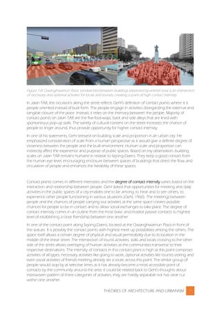
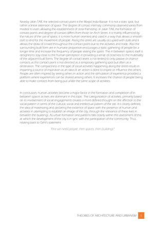
This document provides details about Project 2, which involves a comparative analysis essay of Roponggi Hills in Japan and Jalan Tuanku Abdul Rahman (TAR) in Kuala Lumpur. It discusses the urban patterns, social activities, and contact points found in both areas. For Roponggi Hills, the grid pattern enhances walkability and permeability. Social activities are supported by greenery, transportation, and public spaces. Contact points include a spider sculpture and arena. For Jalan TAR, the five-footway encourages interaction under shade. Back lanes and a shopping mall are important contact points due to the activities and crowds they attract.
The document discusses the concept of tissue analysis, which involves overlaying known urban plans and patterns onto vacant sites to rapidly generate design options. There are three main types of urban tissue: static tissue characterized by consistent small lot patterns; elastic tissue with disordered lot sizes and lack of street networks; and campus tissue consisting of large tracts owned by a single entity with multiple buildings. The document then provides case studies analyzing the tissue composition of three shopping malls in the Atlanta area - Ansley Mall, Perimeter Pointe Shopping Center, and Union Station Mall - to determine their potential for retrofitting.
The document discusses trends that are changing the concept of public space and public life. Specifically, it notes three key trends: 1) the withering of the public realm due to market liberalism and reduced government services, 2) tensions arising from global economic restructuring and corporate power, and 3) rapid technological changes transforming concepts of place and community. It explores how these trends are giving rise to privatized and controlled spaces like corporate plazas, shopping malls, and gated communities that replace traditional public spaces.
The document summarizes research on public spaces in four European cities: Lviv, Manchester, St. Petersburg, and Sofia. The researchers observed how city squares, as traditional public spaces, have changed due to commercialization, privatization, and regulation. While squares have been renovated, they have also limited public access and activities to prioritize consumption. However, the research found that squares still serve some public functions and are sites of protest. The researchers question whether squares should still be considered public spaces and discuss rethinking the concept of public space in modern cities.
This document discusses the internal structure of urban areas, including density patterns and land use classifications. It describes how urban structure aims to minimize the total distance between people and facilities by distributing some facilities locally and relying on transportation systems for other facilities. This creates a hierarchical structure with different levels of central places and transportation networks. The patterns of urban land use that develop are influenced by economic factors like bid rents and land values, which are highest near the urban center and transportation routes.
Perception of Urban Space Shape of an Urban FormSomesh Siddharth
This document provides an overview of key concepts for understanding urban morphology, including:
- Perception of urban space is determined by factors like urban form, massing, and scale. Massing influences how space is perceived, and scale relates to human vision and modes of movement.
- Shape of an urban form is defined by characteristics like size, density, pattern, grain, texture, voids, and routes. Districts, activity structures, orientation, vistas, skylines, and details further shape the urban environment.
- Learning objectives are to understand how to perceive urban environments through determinants of urban form like space, mass, and scale. Key aspects that influence the perception of urban space are discussed.
This document discusses the concepts and objectives of urban morphology. Urban morphology is defined as the study of the physical form and development of human settlements. It examines the shape and structure of settlements as well as their transformation over time under various forces. The document outlines different types of settlement patterns, forms, and structures. It also discusses the determinants that influence a settlement's morphology, including physical, functional, social, cultural, economic, and political factors. The objectives of urban morphology include improving comfort, accessibility, diversity and other qualities of urban form.
This document discusses how architecture can be responsive to its environment and users. It explores how entry spaces, seating areas, public squares, and public art can be designed to better engage with surrounding social, cultural, and environmental contexts. Adaptive architecture is presented as architecture that evolves over time in response to various parameters like weather, energy demands, and user needs. Examples are given of bioclimatic and vernacular designs that are more responsive to their locations. The document concludes that entry spaces and seating areas are major drivers for successful public spaces when designed in consideration of the local public and context.
Urban spatial structure and Types of Urban Spatial Structures. The urban spatial structure can be characterized by its level of centralization and clustering
This document discusses the principles of New Urbanism and its goal of reintroducing urban centers and qualities to city planning. It begins by describing how post-World War II development led to isolated, car-centric communities that lacked the mixed-use, walkable neighborhoods characteristic of traditional urban planning. New Urbanism began in the 1970s-80s to address this by creating neighborhoods and urban centers with human-scale design. The document then outlines some of New Urbanism's key design principles, such as creating walkable communities with a mix of uses and civic spaces embedded within neighborhoods.
Urban design can significantly influence the economic, environmental, social, and cultural aspects of a locality. It determines the order and form of cities with an emphasis on aesthetics. Urban design influences health and how people interact with each other and use public spaces through the arrangement of buildings, public spaces, streets, transportation systems, and landscaping. Well-designed elements come together to create a sense of place and define the quality and character of cities.
Urban design (the functional dimension of designing an urban area)UzmaAbid5
Movement is fundamental to how urban places function. It relates to encouraging people to stop and spend time in public spaces, which generates life and activity. There are two types of movement - vehicular and pedestrian. Pedestrian movement is important as it allows for optional activities beyond basic travel. Space syntax theory explores how urban grid configuration and connectivity relates to pedestrian movement and densities. Well-connected places encourage more pedestrian movement and support a variety of land uses.
CHAPTER 1- THE STREET is the fundamental “city” element, the building block of cities. The street is a delineated area for common use, framed by a collection of individual structures, whose purpose is to serve the function of circulation and exchange: social and material.
CHAPTER 2- THE FOOD & BUSINESS - Power within the food industry is concentrated to dominate the global trade of food and beverages 40% of the total global grocery market. Processed food accounts for three-quarters of global food sales. On average, people spend 20% of their income on food and the global food market.
CHAPTER 3- TRANSFORMATIONS - positive thinking of the creative fields be integrated with the critical inquiry of
This document discusses theories of urban form and city patterns. It begins by defining urban form and some factors that influence city patterns, such as geography, natural environment, and socioeconomic forces. It then examines three common urban patterns: linear, cluster, and hierarchical. The document also discusses urban morphology and the analysis of urban form elements. Finally, it analyzes three early theories of urban form: the concentric zone model, sector model, and multiple nuclei model; and notes some criticisms of each approach.
The document discusses elements that contribute to the legibility and navigability of cities, as analyzed by urban planner Kevin Lynch. It examines four cities - Athens, Paris, Jaipur, and Rome - and how each city utilizes Lynch's elements of paths, edges, districts, and landmarks to create a coherent structure that is easy for people to understand and navigate. The document analyzes features of each city like pathways in Athens, water edges in Paris, distinct districts in Jaipur, and prominent landmarks in Rome that make the layout and organization of each city clear.
Kevin Lynch proposes criteria for evaluating good city form, including vitality, sense, fit, access, and control. He tests these criteria on issues of city size, growth, conservation, and planning practices. The book provides a comprehensive discussion of urban theory and a normative theory relating the value of a city to its spatial characteristics. Lynch argues that independent forces transform human settlements and that the first cities emerged after agricultural revolutions, developing new skills to serve new elites within carefully planned layouts.
Dimensions of public space, lecture by Petar Vranic, 3 July 2013Sochi - peshkom
This document outlines the objectives and program for a summer school on architecture and urban design in Sochi, Russia. The summer school aims to collaboratively understand public spaces and how they influence lifestyle through non-conventional design approaches. Over two weeks, participants will develop their understanding of a chosen public space and factors shaping it, and design scenarios to improve local public spaces through stakeholder engagement and implementation planning. The document discusses dimensions of public space, including political, economic, environmental and social roles. It also examines challenges facing public spaces and how their role and accessibility can become more limited and privatized over time.
“public space or a public place is a place where anyone has a right to come without being excluded because economic or social conditions (fees, paying an entrance, being poor, ...).”
The document provides a comparative analysis of public spaces in Roppongi, Tokyo and Jalan Tuanku Abdul Rahman in Kuala Lumpur based on Jan Gehl's theory of social interaction intensity. It analyzes two specific sites in each city - Fujifilm Square in Roppongi and Sogo Bus Stop in Jalan TAR. Both sites function as important contact points where different activities occur. While they share similarities, factors like architecture, culture and urban design impact the social activities and contact intensity between people. The analysis then examines Tenso Shrine junction in Tokyo and Semua House junction in Kuala Lumpur, identifying both as intersection spots that facilitate various necessary, optional
The document discusses several functional dimensions of urban design including the use of public spaces, density, mixed uses, and privacy considerations. It describes how public spaces should provide comfort, relaxation, passive and active engagement, and discovery opportunities. Higher densities are preferred to lower densities as they support more sustainable development patterns with efficient use of land and resources. Mixed uses that blend residential, commercial and other functions are also highlighted as important for urban vitality.
Lecture 12 Theories of Urban Spatial Designrohayah3
Three main theories of urban spatial design are discussed:
1. Figure and ground theory examines the relationship between solid urban masses (buildings) and open voids (spaces). It aims to establish a hierarchy of enclosed spaces through manipulating the pattern of solids and voids.
2. Linkage theory is based on "lines" that connect urban elements. It focuses on designing networks of paths, streets, and linear open spaces.
3. Place theory combines the above by giving contextual meaning to spaces based on cultural and human factors. A place is complete when architecture achieves a sense of unity and is visually appropriate for the context. Together, the theories aim to comprehensively understand and design urban form and spaces.
Architectural design and its attributes have evolved over a period of time. Form and Function are its two major aspects and the sense of perception involves with these entities forms the basic subject the following slide show.
The document discusses 30 key concepts for urban development that are important for professional discussions at urban planning forums. It begins with definitions of several concepts like "aerotropolis," "agglomeration," and "brownfield" to establish common vocabulary. It then discusses concepts related to different sections at the Moscow Urban Forum like "finance & governance," "infrastructure & technologies," and "planning & housing." The document aims to enlarge the vocabulary around urban development in order to improve urban planning and management.
This document discusses the key elements of urban design: buildings, public spaces, streets, transport, and landscape. It provides examples for each element. Buildings shape urban spaces and give a sense of place. Public spaces are living rooms of the city where people gather. Streets connect spaces and are defined by their dimensions, scale, and surrounding buildings. Transport networks enable movement throughout cities. Landscape includes green spaces like parks and trees that provide contrast. Together these elements are woven into the overall urban design structure.
Theories of Architecture and Urbanism Comparative Analysis Essaydouglasloon
Taylor's University Lakeside Campus
School of Architecture, Building & Design
Bachelor of Science (Hons) in Architecture
Theories of Architecture & Urbanism (ARC 61303)
Theories of Architecture and Urbanism Project Part 2Tan Jaden
This document compares the urban spaces of Jalan Tuanku Abdul Rahman in Kuala Lumpur and Central Hong Kong. It finds that Central Hong Kong has a more permeable pedestrian environment with blurred boundaries between different land uses, supporting a variety of daily social activities. In contrast, Jalan TAR has a more planned separation of uses with less organic social interaction. Both spaces show an evolution from traditional shophouses to modern development, but Central Hong Kong has found a way to better integrate the old and new in a living city.
The document provides a comparative analysis of Statue Square in Central District, Hong Kong and Jalan Tuanku Abdul Rahman in Kuala Lumpur, Malaysia based on Jan Gehl's theories of outdoor activities and human contact intensity. It analyzes how the urban design and public amenities of each space influence the types of activities that occur and the levels of human interaction. Both spaces effectively accommodate necessary, optional, and social activities through features like seating, shade, and green spaces. However, differences in climate and urban planning result in varying consistency and intensity of social activities between the two areas.
Theories of archi and urbanism comparative-essaySheau Hui Tan
This document provides a comparative analysis of public spaces between buildings in Ho Chi Minh City, Vietnam and Kuala Lumpur, Malaysia. It analyzes the urban morphology, historical development, and patterns of social activities in specific areas of each city. In Ho Chi Minh City, social activities commonly occur along streets with vendors and at road junctions. In Kuala Lumpur, socializing typically takes place in building plazas and along streets with stalls. Both cities demonstrate that necessary and optional activities in public spaces can foster social interactions, as predicted by urban theorist Jan Gehl.
DEGREE SEM 5 THEORIES OF ARCHI. & URBANISM COMPARATIVE ESSAYjolynnTJL
This document provides a comparative analysis of public spaces in Central, Hong Kong and Kuala Lumpur, Malaysia. It analyzes three contact points along Queen's Road Central in Hong Kong and compares them to areas in Jalan Tuanku Abdul Rahman, Kuala Lumpur. The contact points exhibit varying levels of social interaction and activity depending on factors like space scale, building function and variety, and pedestrian movement speed. Certain alleys in Kuala Lumpur lack unique identity and over-commercialization limits social interaction, compared to Graham Street market in Hong Kong which fosters neighborhood interactions. The analysis applies theories from Jan Gehl's "Life Between Buildings" to understand how urban design impacts public
This document is a comparative analysis essay analyzing the public spaces of Jalan Tuanku Abdul Rahman in Kuala Lumpur, Malaysia and Sejong Daero in Seoul, South Korea. It examines the scale, movement patterns of pedestrians, types of contact points, and degree of contact intensity in both locations based on the theories of Jahn Gehl. While Jalan TAR features dense shophouses and narrow alleys that encourage social gatherings, Sejong Daero has a larger scale with highways that scatter pedestrian movement. Both locations provide different social experiences for pedestrians due to varying qualities of their public spaces.
The document provides a comparative analysis of Petaling Street in Kuala Lumpur and West Monroe Street in Chicago based on three principles of urban structure: form, activity, and movement patterns. Form considers built structures and open spaces. Activity analyzes land use and functions. Movement patterns examine traffic and pedestrian flows. Based on Jan Gehl's theories, the streets are compared on how urban design impacts social interactions. Petaling Street features dense shophouses with limited open spaces, while West Monroe Street has more plazas but lacks a distinct cultural identity. Both streets facilitate social contact, but their designs differentially encourage public life.
This document provides a comparative analysis of Petaling Street in Kuala Lumpur, Malaysia and Newbury Street in Boston, USA based on Jan Gehl's theories of public space from his book "Life Between Buildings". Both streets are shopping destinations but offer different social experiences. Petaling Street features food stalls and merchandise displays that encourage interaction, while Newbury Street has indoor stores and sidewalk cafes that enable chance encounters. Though similar in diversity of users, the streets differ in occurrence and intensity of contact points like visual connections, conversations, and planned versus spontaneous gatherings.
This document provides a comparative analysis of Jalan Braga in Bandung, Indonesia and Jalan Besar in Klang, Malaysia. It examines the streets in terms of social patterns, outdoor activities, and contact points based on Jan Gehl's theories of urban design and public life. Several key contact points are identified and compared between the streets, including sidewalks/walkways, prominent eateries, open spaces, and street features. While the streets share some similarities, differences in climate, built environment, and culture result in varying intensities and types of social contact at each location. The analysis provides insights into how physical planning can influence human behavior and the quality of public life in urban spaces.
This document compares social patterns in Petchaburi Road, Bangkok and Jalan Tunku Abdul Rahman in Kuala Lumpur. There are both similarities and differences in urban form, contact points, and street culture between the two areas. A key difference is that buildings in Petchaburi Road lack setbacks while buildings in Jalan Tunku Abdul Rahman have "five-foot ways" that provide covered pedestrian areas. This impacts how people engage with the street and each other. Both areas have contact points near markets and shopping areas, showing the influence of market culture.
This document provides a comparative analysis of two Asian streets - Pham Ngu Lao in Vietnam and Jalan Besar in Malaysia - based on Jan Gehl's theories of architecture and urbanism. It identifies and analyzes key contact points on each street, including sidewalks/walkways, food establishments, and waiting areas. While the streets share similarities as urban contexts in Southeast Asia, differences in activities, social patterns, and physical environments lead to varying degrees of contact intensity between people. The analysis provides insights into how the built environment influences public life and social interaction.
This document provides a comparative analysis of social activities and contact points between Charoen Krung Road in Bangkok, Thailand and Jalan Besar in Klang, Malaysia. It analyzes the pattern of social activities in both areas and identifies key contact points based on Jan Gehl's theories of urban design. In Charoen Krung Road, social activities are highly concentrated along the commercial areas, with contact points at a busy shopping mall entrance and food market. In Jalan Besar, abandoned shophouses have reduced social interaction, but restaurants and local shops along the sidewalk remain active contact points. Both areas demonstrate high social interaction at commercial areas and food vendors.
This document is a comparative analysis essay on two public spaces - Dataran Medan Pasar in Kuala Lumpur, Malaysia and Ta Hien Street in Hanoi, Vietnam. It analyzes the urban form, planning theories, and social activities that have influenced the intensity of social contact in each space. Dataran Medan Pasar was once a vibrant public square but has become fragmented due to urban development that dispersed people and events. Ta Hien Street is a narrow pedestrian street that utilizes compact urban form to integrate activities and assemble people, promoting social interaction. While both have undergone urbanization, Ta Hien Street's centralized development has created an active public realm compared to Dataran Medan Pasar
This document provides an analysis of the social patterns and contact points along two streets: Phetchaburi Road in Bangkok, Thailand and Jalan Tuanku Abdul Rahman in Kuala Lumpur, Malaysia. It finds that both streets are centers of commercial activity that attract local communities and tourists. Phetchaburi Road has a higher intensity of social activities due to its many street food stalls and shops. Contact points on Phetchaburi Road like Shibuya Pratunam and a mosque generate different intensities of social contact through chance meetings, small group interactions, and shared activities like shopping and prayers. Jalan TAR also fosters socializing through covered walkways between shops. The document
The document provides a comparative analysis of two streets - Pham Ngu Lao Street in Ho Chi Minh City, Vietnam and Jalan Reko-Jalan Tukang-Jalan Mendaling in Kajang, Malaysia. It analyzes five common contact points on the streets: eatery nodes, alleyways, public spaces, shaded seating areas, and entrances. For eatery nodes, it compares two corner restaurants, Pho Quynh and Restaurant 2233, finding they both attract people through their local cuisine but have different environments that influence social interactions and contact intensity.
Comparative Essay - Carmen Chan 0326485Carmen Chan
The document provides a comparative analysis of two streets - Jalan Sulaiman and Jalan Tun Abdul Aziz in Kajang, Malaysia and Samcheongdong Street in Seoul, South Korea. It analyzes factors like alleys, outdoor seating, built edges, paths and walkways based on Jan Gehl's theory of urban design. The alley in Samcheongdong Street is found to be more attractive due to its larger size, transparency and direction towards strong cultural destinations. Outdoor seating in both streets is deemed uncomfortable as pedestrians are exposed to surrounding traffic. Overall, the analysis examines how physical design influences human activity and comfort in public spaces.
Comparative essay theories of architecture and urbanismAnith Syazlin
This document provides a comparative analysis of University Belt in Manila, Philippines and Medan Pasar in Kuala Lumpur, Malaysia. It analyzes the urban culture, public/private spaces, and street typology of both areas. University Belt has high intensity of interaction due to its abundant public transportation, while Medan Pasar serves as a transportation hub. Plaza Miranda in University Belt is a public space for events, while Medan Pasar's square is a transition area. Gonzalo Puyat Street in University Belt is an informal market street, while Kuala Lumpur's Kasturi Walk is a covered commercial area. Both showcase the interplay between informal and formal urban environments.
This document provides a comparative analysis of public spaces in Chinatown Kuala Lumpur and Massachusetts Avenue in Cambridge. It analyzes the different types of activities and degrees of social contact that occur in specific sites within each location, such as religious buildings, markets, schools, and public squares. The analysis finds that street designs and policies that encourage walking and public transportation support more opportunities for optional and social activities. In contrast, areas with less consideration for street design and changing demographics experience fewer contact points and social interaction. Overall, the document examines how urban planning and physical conditions can influence social patterns and the use of public spaces.
The document provides a comparative analysis of contact points and social activities in the Chinatowns of Philadelphia and Kuala Lumpur. It analyzes several contact points in each location based on Jan Gehl's theories of necessary, optional, and social activities. In Philadelphia, contact points are more element-oriented like storefronts and design features, while in Kuala Lumpur they are more people-oriented with many social activities that increase contact intensity. Overall, the analysis found that good walkability does not necessarily correlate with higher chances for social contact, as the more organic layout in Kuala Lumpur supported more opportunities for interaction between people.
The document provides a comparative analysis of Nam Cheong Street in Sham Shui Po, Hong Kong and Jalan Mendaling in Kajang, Malaysia. It analyzes four contact points: 1) Street and building typology, noting differences in parking and pedestrian flow. 2) Sidewalks and bus stops, and their influence on pedestrian routes. 3) Food stalls, with one open long hours in Hong Kong and one only in mornings in Malaysia. 4) Pocket parks and public spaces, with one park preferred for its shade and greenery over a hot public space. The analysis concludes human behavior is shaped by the built environment's promotion of social activities and street culture.
Similar to Comparing Jalan TAR and Gwanghwamun (20)
[MGT60403] Project Management Final Report Joyce Wee
The document discusses the benefits of exercise for mental health. Regular physical activity can help reduce anxiety and depression and improve mood and cognitive functioning. Exercise causes chemical changes in the brain that may help protect against mental illness and improve symptoms.
This document is an architectural design project report for a proposed Food Discovery Centre in Taman Tasik Titiwangsa, Kuala Lumpur. It includes an introduction to the project, site analysis, design intentions and strategies. The project aims to create a platform for the local community to rediscover food cultures and slow down their pace of life. The report outlines the site context, program requirements, spatial layout, and environmental strategies including orientation, shading and sustainability concepts. The design intends to tell the story of the place through interconnected spaces and revive the history of the lake through exhibitions on tin mining.
The document discusses a design strategy to direct visitors to proposed new buildings at sites B and C. It aims to study patterns of pedestrian traffic to best utilize existing passages and direct foot traffic to the new structures. References are provided for other artist residency and cultural center projects.
This research proposal examines the evolution of food culture in Malaysian night markets. It will compare traditional night market stalls to newer food trucks that have entered the market. The research aims to explore how differences in food presentation and preparation attract different target groups. It will also question whether food trucks are just a passing trend or will significantly impact Malaysia's food culture over time by potentially causing the loss of originality in traditional dishes. The research will be conducted through observation of food stalls and trucks as well as interviews with consumers.
The document provides details about the acoustic design of an auditorium for the Sidang Injil Borneo Kuala Lumpur church. It discusses the building and auditorium layout, sound absorption and finishing materials used, the sound system and sources, and how sound propagates through the space. Absorptive materials like carpet, fabric, and timber are used on floors, walls and ceilings to reduce reverberation. The sound system includes various speaker types to distribute sound evenly. Potential noise intrusion areas are also identified.
The document describes an auditorium with a fan-shaped volume of 11393 cubic meters and total floor area of 2120 square meters, with a seating capacity of 1500 people. It is designed for both speech and music with various acoustic paneling and speaker configurations to properly treat and distribute sound throughout the large, irregularly shaped space.
The document summarizes a reaction paper about the text "Towards a Critical Regionalism" by Kenneth Frampton. Frampton discusses balancing modern techniques with traditional forms and consideration of the surrounding natural environment to create buildings with a unique sense of place. The student agrees that critical regionalism requires moderate adaptation of modern designs with consideration of tangible context. Additionally, the student believes that architecture should engage more than just sight and should incorporate how spaces make the body and mind react through tactility. Bridging tectonics and tactility is seen as essential to forming buildings with both a universal and cultural identity.
The document discusses the importance of architecture that evokes emotion and memory in people. It summarizes a text arguing that architecture should fulfill human needs and feelings contextually rather than just having a distinctive formal design. The author believes architecture should provoke memories through spatial details and ambience. A reaction is given agreeing that good architecture can remind people of their past experiences and memories in a way that art does. The conclusion is that successful architecture achieves emotional resonance by interacting with people's memories in a dynamic yet expressive way.
The document discusses a reaction paper analyzing the text "Learning from Las Vegas" by Robert Venturi, Denise Scott Brown, and Steven Izenour. The paper argues that while architects focus on spatial characteristics as defining architecture, the authors correctly point out the importance of symbolism and iconology. This is evidenced by the Las Vegas Strip, where large symbolic signs provide orientation in the vast desert spaces and have become the unifying architectural style. In conclusion, the paper finds that architecture and symbolism are inseparable and relevant, with symbols enhancing rather than diminishing the spatial aspects of design.
The document summarizes the student's 8-week internship experience at aLM Architects. During this time, the student assisted with various projects including residential, commercial and institutional buildings. Tasks involved design work, drafting, attending meetings, and participating in a site visit. The student gained exposure to different stages of design and regulatory requirements. Overall, the internship provided valuable hands-on experience of an architectural practice.
Building Services in Public Buildings | Elderly CentreJoyce Wee
The document provides an overview of the building services systems proposed for an elderly care centre, including fire protection, air conditioning, mechanical ventilation, and mechanical transportation systems. It discusses active and passive fire protection, various air conditioning system types, supply, exhaust and balanced ventilation systems, and vertical transportation via elevators. The proposed fire protection includes detection, alarms, sprinklers and extinguishers. A variable refrigerant flow split unit air conditioning system is recommended.
Beam and Column Analysis | Individual ComponentJoyce Wee
This document provides calculations for the dead loads, live loads, and ultimate loads on several beams in a building structure. For beam A-B/4, the total dead load is 13.34kN/m and total live load is 4.24kN/m, resulting in an ultimate load of 25.46kN/m. The reaction forces at supports A and B are calculated to be 39.46kN and 39.5kN respectively. Similar load calculations are provided for several other beams.
1. The document analyzes the internal forces of a roof truss through calculating the reaction forces and analyzing each joint.
2. It is calculated that the reaction forces are 218.75 kN, 31.25 kN, and 200 kN.
3. Each joint is then analyzed by applying equilibrium equations to calculate the internal tensile and compressive forces. Diagrams are provided to illustrate the analysis.
Beam and Column Analysis | Group ComponentJoyce Wee
This document presents the structural analysis of a double-storey bungalow conducted by a group of students. It includes architectural plans, structural plans, analysis of the slab and tributary area, assumptions of dead and live loads, and the distribution of beams and columns among group members. Calculations will be performed to analyze individual beam and column components based on the load assumptions and distributions.
The document discusses the history and development of chocolate over centuries. It details how cocoa beans were first used by Mesoamerican cultures before being introduced to Europe, where it became popular in drinks and confections. The document also notes that modern chocolate production methods were established in the 19th century to allow chocolate to be consumed on a larger scale worldwide.
Building Construction: Experiencing ConstructionJoyce Wee
The document provides information about a low density housing development called Ramal Villa located in Kajang, Malaysia. It consists of 71 units including single detached homes and semi-detached homes. The development emphasizes modern design with flat roofs and simple facades. Each unit also has a rooftop garden. The site is well connected to major highways near LDP and Sungai Besi Highway, making it easily accessible. The document includes a location plan and site plan showing the layout of the different housing types.
Cape Rachado Reserve Forest Site AnalysisJoyce Wee
This document provides an analysis of existing structures at Cape Rachado site in Port Dickson, Malaysia. It describes various pathways, stairs, railings, retaining walls, gazebos, signboards, benches, observatory decks, picnic tables, and a beach gazebo. For each structure, it details materials used, dimensions, strengths, and weaknesses. Concrete and reinforced concrete are common materials used due to durability. Structures blend into the natural surroundings using materials like wood and adopting traditional Malay design elements. The document evaluates each structure's suitability for the site and visitors.
Stadium Negara is the first indoor stadium built in Malaysia, located in Kuala Lumpur. It was designed by the Public Works Department and constructed between 1960-1962 at a cost of RM34 million. The original roof structure spanned 300 feet without columns, but it was replaced in the 1980s with a domed roof. The stadium has hosted many sporting and cultural events over the years and was designated a national heritage building in 2003 for its architectural and historical significance.
Our excursions in tahiti offer stunning lagoon tours, vibrant marine life encounters, and cultural experiences. We ensure unforgettable adventures amidst breathtaking landscapes and serene waters. For more information, mail us at tracey@uniquetahiti.com.
Assessing the Influence of Transportation on the Tourism Industry in Nigeriagsochially
This research dissertation investigates the complex interplay between transportation and the tourism industry in Nigeria, aiming to unravel critical insights that contribute to the enhancement of the overall tourist experience. The study employs a multi-faceted approach, literature review establishes a robust theoretical framework, incorporating The Service Quality and Satisfaction Theory to guide the research questions and hypotheses.
The methodology involves the distribution of a structured questionnaire, ensuring a representative sample and facilitating a comprehensive analysis of the gathered data.
Key findings include the nuanced perceptions of transportation infrastructure adequacy, safety and security concerns, financial influences on travel decisions, and the cultural and ecological impacts of transportation choices. These findings culminate in a comprehensive set of recommendations for policymakers and practitioners in the Nigerian tourism industry. The findings contribute to the existing literature by providing actionable insights for policymakers, stakeholders, and researchers in the Nigerian tourism sector.
The recommendations encompass gender-sensitive planning, infrastructure enhancements, safety measures, and strategic interventions to address financial constraints, ensuring a holistic and sustainable development of the tourism industry in Nigeria.
Author: Imafidon Osademwingie Martins
Best Places to Stay in New Brunswick, Canada.Mahogany Manor
New Brunswick, a picturesque province in eastern Canada, offers a plethora of unique and charming places to stay for every kind of traveler. From the historic allure of Fredericton and the vibrant culture of Saint John to the natural beauty of Fundy National Park and the serene coastal towns like St. Andrews by-the-Sea, there's something for everyone. Whether you prefer luxury resorts, cozy inns, rustic lodges, or budget-friendly options, the best places to stay in New Brunswick ensure a memorable stay, allowing you to fully immerse yourself in the province's rich history, stunning landscapes, and warm hospitality.
https://www.mmanor.ca/blog/best-5-bed-and-breakfast-new-brunswick-canada
Wayanad-The-Touristry-Heaven to the tour.pptxcosmo-soil
Wayanad, nestled in Kerala's Western Ghats, is a lush paradise renowned for its scenic landscapes, rich biodiversity, and cultural heritage. From trekking Chembra Peak to exploring ancient Edakkal Caves, Wayanad offers thrilling adventures and serene experiences. Its vibrant economy, driven by agriculture and tourism, highlights a harmonious blend of nature, tradition, and modernity.
How do I plan a Kilimanjaro Climb?
Planning to climb Mount Kilimanjaro is an exciting yet detailed process. Here’s a step-by-step guide to help you prepare for this incredible adventure.
Un viaje a Buenos Aires y sus alrededoresJudy Hochberg
A travelogue of my recent trip to Argentina, most to Buenos Aires, but including excursion to Iguazú waterfalls, Tigre, and Colonia del Sacramento in Uruguay
BTW UK Visa Application Process, Uk Visa complete guide, Uk Visa fees, requirements and application process. Know all about uk visa and best way to apply for the uk visa. Get to know about the requirements that allows you for the faster visa appliaction. BTW UK Visa Application Process, Uk Visa complete guide, Uk Visa fees, requirements and application process. Know all about uk visa and best way to apply for the uk visa. Get to know about the requirements that allows you for the faster visa appliaction. BTW UK Visa Application Process, Uk Visa complete guide, Uk Visa fees, requirements and application process. Know all about uk visa and best way to apply for the uk visa. Get to know about the requirements that allows you for the faster visa appliaction. BTW UK Visa Application Process, Uk Visa complete guide, Uk Visa fees, requirements and application process. Know all about uk visa and best way to apply for the uk visa. Get to know about the requirements that allows you for the faster visa appliaction. BTW UK Visa Application Process, Uk Visa complete guide, Uk Visa fees, requirements and application process. Know all about uk visa and best way to apply for the uk visa. Get to know about the requirements that allows you for the faster visa appliaction. BTW UK Visa Application Process, Uk Visa complete guide, Uk Visa fees, requirements and application process. Know all about uk visa and best way to apply for the uk visa. Get to know about the requirements that allows you for the faster visa appliaction. BTW UK Visa Application Process, Uk Visa complete guide, Uk Visa fees, requirements and application process. Know all about uk visa and best way to apply for the uk visa. Get to know about the requirements that allows you for the faster visa appliaction. BTW UK Visa Application Process, Uk Visa complete guide, Uk Visa fees, requirements and application process. Know all about uk visa and best way to apply for the uk visa. Get to know about the requirements that allows you for the faster visa appliaction. Get information in this PDF and simplyfy your visa process.
The Power of a Glamping Go-To-Market Accelerator Plan.pptxRezStream
Unlock the secrets to success with our comprehensive 8-Step Glamping Accelerator Go-To-Market Plan! Watch our FREE webinar, where you'll receive expert guidance and invaluable insights on every aspect of launching and growing your glamping business.
How To Talk To a Live Person at American Airlinesflyn goo
This page by FlynGoo can become your ultimate guide to connecting with a live person at American Airlines. Have you ever felt lost in the automated maze of customer service menus? FlynGoo is here to rescue you from endless phone trees and automated responses. With just a click or a call to a specific number, we ensure you get the human touch you deserve. No more frustration, no more waiting on hold - we simplify the process, making your travel experience smoother and more enjoyable.
1. THEORIES OF ARCHITECTURE AND URBANISM 1
Theories of Architecture and Urbanism [ARC 61303]
PROJECT #2: COMPARATIVE ANALYSIS ESSAY
SEJONG-DAERO, SEOUL
VS.
JALAN TUANKU ABDUL RAHMAN, KUALA LUMPUR
Tutor: Mr Prince Favis Isip
Joyce Wee Yi Qin
0319602
2. THEORIES OF ARCHITECTURE AND URBANISM 2
“The importance of a street as a public open space is one of the most critical
characteristic within the public realm in cities.”
-(Gehl, 1987)
Gwanghwamun Plaza, Sejong-Daero, Seoul
Located in the historic centre, Gwanghwamun Plaza has a long and turbulent history. During the
Japanese occupation of Korea, the colonial government built a large governmental building
between the royal palace and plaza, destroying the traditional symbolic relation of the two. Later
the South Korean government also built an administrative complex right next to the plaza. The
plaza was therefore always an important place, where the state institutions were located and their
power was represented. Yet the plaza is also a place where citizens contested the state power.
Several historic events took place on the plaza, which is sometimes called the “prototype public
space in Korea.” The history of the Gwanghwamun Plaza therefore not only represents the state
but also the South Korean civic society. Yet, decades of rapid urbanisation turned the
Gwanghwamun Plaza into a large expressway, rather than public plaza it should be.
Sejong-Daero is one of the arterial street of Seoul, Korea. The street starts from Gwanghwamun,
one of the gates of the Royal Palace and stretches towards the City Hall. The street fell under the
urban redevelopment scheme when Seoul announced its plan of having a balanced urban
development in 2012, making the street more walkable.
Jalan Tuanku Abdul Rahman, Kuala Lumpur Malaysia
Built to accommodate the growing tin mining industry, Jalan Tuanku Abdul Rahman (Jalan TAR)
shares the similarity with Sejong-Daero as both streets has strong historical backgrounds. The street
is known for its textile shops and the hidden gems at the nooks and corners.
With the urban development happening around it, Jalan TAR seems to be a human-scaled town
cradled within the urban city, adding hints of closeness within the concrete jungle.
In this comparative essay, both streets will be put in comparison in terms of walkability, public
space, possibilities of contact points and contact intensities based on personal observations and
online sources.
3. THEORIES OF ARCHITECTURE AND URBANISM 3
“Social activity” is defined as an interaction that takes place only with the presence of more than one
person, to allow exchange of views, thoughts and experiences; an action taken by a group of people
in relation to the characteristic of experience an behaviour. It is a catalyst affecting the relationship
between the people, the community and the spaces within the urban context. As per Jan Gehl’s
description in “Life Between Buildings”, activities can be categorized into 3 levels, necessary activity,
optional activity and social activity at which he also mentioned social activity as the resultant of
necessary and optional activity (Gehl, 2006). Social activities are very much driven by the conditions
of the public spaces as it takes place when people are present simultaneously to interact.
As mentioned, social activity is often influenced by the social pattern of the place. We will first look
into the possible physical factors affecting the occurrence of social activity, including the coverage of
public spaces, walkable paths and distribution of nodes, along with the intangible factors on Sejong-
Daero.
Walkability
In reference to Gehl’s theory, social activities are supported, indirectly, whenever necessary and
optional activities are given better conditions in public spaces (Gehl, 2006). The “condition” as
mentioned is interrelated with the physical condition that affect the walkability of the street. Along
Sejong-Daero, there are multiple access points for public transportations. The distribution of stations
promotes social engagement as the intensity of people walking down the street increases as it has
become a necessary activity for the locals to transverse in the city. Moreover, the canopied and wide
sidewalks encourage pedestrian to transverse between proximate destinations by foot. With the
combination of these factors, it is possible to slow down the pace of the arterial road although urban-
scaled, making it more susceptible to social activities. Hence relating to Gehl’s statement where social
activities are the resultant of necessary and optional activities.
The social pattern on Sejong-Daero are created by different communities including locals, students,
white collars, tourists etc. It is identified that the activities on Sejong-Daero are driven by necessary
activities where the people would pass by to get to their respective destinations. The layering of
these activities creates a social pattern through the nature of the activities and the paths they walk.
Figure 1: The diagram indicates the integration of stops, walks and vegetation in creating a more conducive
and comfortable walk between destinations.
4. THEORIES OF ARCHITECTURE AND URBANISM 4
Figure 2-5: The diagram indicates the layering of different communities, hinting the intersection of
communities on the system of spaces and canopied walks.
5. THEORIES OF ARCHITECTURE AND URBANISM 5
On Jalan TAR, the most significant physical element is the five-foot-way that provides canopy to the
pedestrians. The covered space under is another form of public space that allows human contact. It
was mentioned above that physical conditions are interrelated with the possibility of social activities as they
affect the walkability and function of the space. In this case, five-foot-ways are not only a feature of the
conserved architecture style, it also encourages human flow under its canopy. This element has been the
main mode of pedestal transverse between destinations since the start. It has created a constant flow of
human circulation along the public space at the frontage of each shop, providing a favourable platform for
communication and interaction between one another.
Figure 6: The diagram is a section of Jalan TAR, showing the interaction between the street, walks and the
pedestrian. It is evident that the back alley is more happening compared to the main sidewalks.
Briefly, Kenneth Frampton mentioned, “It is symptomatic of the priority given to sight that we find it necessary
to remind ourselves that the tactile is important dimension in the perception of built form. One has in mind a
whole range of complementary sensory perceptions which are registered by the labile body”
(Frampton,1981). In relation to the Jalan TAR context, the space underneath the canopy envelops the users,
triggering their senses with the enclosure, sensory and visual of lighting.
Personally, I think tactile application should not be limited to spaces within built forms. Public spaces can also
be incorporated with tactility to complement it through sensory experiences.
Public Spaces: Parks and Plazas
In “Life between Buildings”, Gehl mentioned vehicular traffic and scale as two of the factors that
will cause an impact to the intensity of social activities outdoors. Through analytics, streets with little
traffic and more humane scale are more susceptible to outdoor activities where children played on
sidewalks and entrances were used widely for outdoor stays. (Gehl, 2006)
Sejong-Daero is an urban scale arterial street with multi-storey buildings, extensive automobile
traffic and long distances between buildings and function. In efforts of making Seoul a walkable
city, parks and plazas were inserted into the street to break down the scale of the traffic and also
the distance between functions. One of the significant change is the Gwanghwamun Square that
stretches parallelly with Sejong-Daero, as a divider of the two-way traffic. The Square breaks down
the initially 10-laned traffic to 5 lanes on each side of the island-like square, creating another space
for possible social activity occurrence.
6. THEORIES OF ARCHITECTURE AND URBANISM 6
Figure 7: Huge plazas scattered along Sejong-Daero are hotspots shared by the different communities.
Events are held from time to time to spark social activity amongst the people.
Although Jalan TAR lacks parks and plazas, it is more walkable than Sejong-Daero because of its
scale. Plazas on Jalan TAR serves as a gap between buildings that promotes permeability, creating
grids. Instead, public spaces that sparks social activities on Jalan TAR are the back alleys where the
rear of the buildings are close together, and are free of vehicular access.
“Contact point” is defined as a spot or place where people get to meet one another and allow
more intimate level of interactions to happen. The type of contact points varies accordingly due to
the degree of the contact forms between individuals. In Kevin Lynch’s “Image of the City”, a
strategic focus point for orientation like squares and junctions is defined as a node (Lynch,1960).
The surfacing intention of a contact point is similar to Kevin Lynch’s way of defining a node where
the recognition of a concentrated place is defined by the perception and directional senses of
people rather than the built form. Ultimately, a node defines the urban form through the vision of
the people and way finding while a contact point is formed through the experience of the visual
and intimate sensory established in connection between people.
On Sejong-Daero, the type of contact points was found to be similar in terms of its context with the
surrounding elements, mostly built form. It relies on the adjacent objects to draw crowds and made
use as a focal point of a certain junction or intersection. Most of the contact points are found to be
located at opened or shady spaces in front of buildings where a possible waiting area is provided,
or in radial reference to landmarks.
One of the contact point identified along Sejong-Daero is the Gwanghwamun Square in front of
the Palace Gates, where the level and opportunities of contact has to be the derivative factor from
the existence of the statues that draws people, especially tourists, intentionally. Other activities in the
square, on the other hand, becomes the secondary attraction that attracts locals, hence leading to a
bigger crowd. It relates back to Gehl’s statement where activity is an attraction at which the
opportunity of being in the same space, making observation on other’s action and reaction, sharing
the experience through visual and actions. Hence, people will stop by to engage with the
community.
7. THEORIES OF ARCHITECTURE AND URBANISM 7
Figure 7-8: Gwanghwamun Plaza, sandwiched between buildings separated by arterial road, is an intersection
of necessary and optional activities for locals and tourists, creating a point of high contact intensity.
In Jalan TAR, the occasions along the street reflects Gehl’s definition of contact points where it is
people oriented instead of built form. The people engage in activities disregarding the external and
tangible closure of the place. Instead, it relies on the intimacy between the people. Majority of
contact points on Jalan TAR are the five-foot-ways, back and side alleys that are lined with
spontaneous pop-up stalls. The variety of cultural content on the street increases the chance of
people to linger around, thus provide opportunity for higher contact intensity.
In one of his statements, Gehl stressed on building scale and proportion in an urban city. He
emphasized consideration of scale from a human perspective as it would give a definite degree of
closeness between the people and the built environment. Human scale and proportion can
indirectly affect the experience and purpose of public spaces. Based on my observation, building
scales on Jalan TAR remains humane in relative to Sejong-Daero. They keep a good contact from
the human eye level, encouraging enclosure between spaces of buildings that direct the flow and
circulation of people and enhances the liveability of these spaces.
Contact points comes in different intensities and the degree of contact intensity varies based on the
interaction and relationship between people. Gehl stated that opportunities for meeting and daily
activities in the public spaces of a city enables one to be among, to hear and to see others, to
experience other people functioning in various situations (Gehl, 1960). The meetings between
people and the chances of people carrying out activities at the same space creates possible
chances for people to be in contact and to allow social exchanges to take place. The degree of
contact intensity comes in an outline from the most basic and modest passive contacts to highest
level of establishing a close friendship between one another.
In one of the contact point along Sejong-Daero, located at the Gwanghwamun Plaza in front of
the statues. It is possibly the contact points with highest meet up possibilities among the others. The
space itself allows a certain degree of physical and visual permeability due to its location in the
middle of the linear street. The intersection of tourist activities, stalls and locals crossing to the other
side of the street allows overlaying of human activities as the communities transverse to their
respective destinations. The intensity of contacts in this contact point is high as this point comprises
activities of all types, necessary activities like going to work, optional activities like tourists visiting and
even social activities of friends meeting already set a route across this point. The similar group of
people would stop by at selective times as it has already become a most accessible point of
contacts by the community around the area. It could be related back to Gehl’s thoughts about
interwoven pattern of three categories of activities, they are hardly separable nor has clear cut
within one another.
8. THEORIES OF ARCHITECTURE AND URBANISM 8
Nearby Jalan TAR, the selected contact point is the Masjid India Bazaar. It is not a static spot, but
rather a linear extension of space. The degree of contact intensity commonly observed varies from
modest to even allowing the establishment of close friendship. In Jalan TAR, the formation of
contact points and degree of contact differs from those on Arch Street. It is mainly influenced by
the nature of the use of space, it is more human oriented and used in a way that allows a smooth
start to end for the movement of people. Along the street are usually occupied with stalls and it
allows the draw of crowd throughout the contact point due to the activities and trade. Also the
surrounding built form are in humane proportion encourages a static gathering of people for a
longer time and increase the frequency of people visiting the space. The in between spaces itself is
designed to stay close to the human perception in providing a sense of closeness to the materiality
of the adjacent built forms. The degree of contact levels is not limited to only passive or chance
contacts as this contact point is not directed as a temporary gathering spot but often as a
destination. The compactness in the type of social activities happening along the street results in
imparting a source of inspiration as an idea or an action is done to inspire or influence the others.
People are often inspired by seeing others in action and the stimulation of experience provided a
platform where experiences can be shared among others. It increases the chance of people being
able to make contacts from being put under the same scope of activities.
In conclusion, human activities become a major factor in the formation and completion of in
between spaces as lives are dominant in this topic. The categorization of activities, primarily based
on its involvement of social engagements creates a more defined thought on the affection to the
social pattern in terms of the cultural, social and intellectual pattern of the site. It is clearly defined,
the idea of maximizing and declaring the existence of space with the presence of human and
activities in attempting to establish an image of the city, through the relevance of these lives in
between the buildings. As urban formation and patterns falls closely within the assessment of this
at which the development of the city is in sync with the participation of the community. Thus,
relating back to Gehl’s statement
“First we need people, then spaces, then buildings”
9. THEORIES OF ARCHITECTURE AND URBANISM 9
REFERENCES
A History of Architecture - Critical Regionalism. (2016). Historiaztuki.com.pl. Retrieved 24 June 2017,
from http://www.historiasztuki.com.pi/kodowane/003-02-05-ARCHWSP-REGIONALIZM-eng.php
Lynch, K. (1960). The Image of the City (1st ed). Cambridge, Mass.: MIT Press.
Pallasmaa, J. (1996). The Geometry of Feeling: A Look at the Phenomenology of Architecture. NY:
Princeton Architectural Press.
Spaces, P. (2016) Jan Gehl - Project for Public Spaces. Project for Public Spaces. Retrieved 25 June
2017, from http://www.pps.org/reference/jgehl/