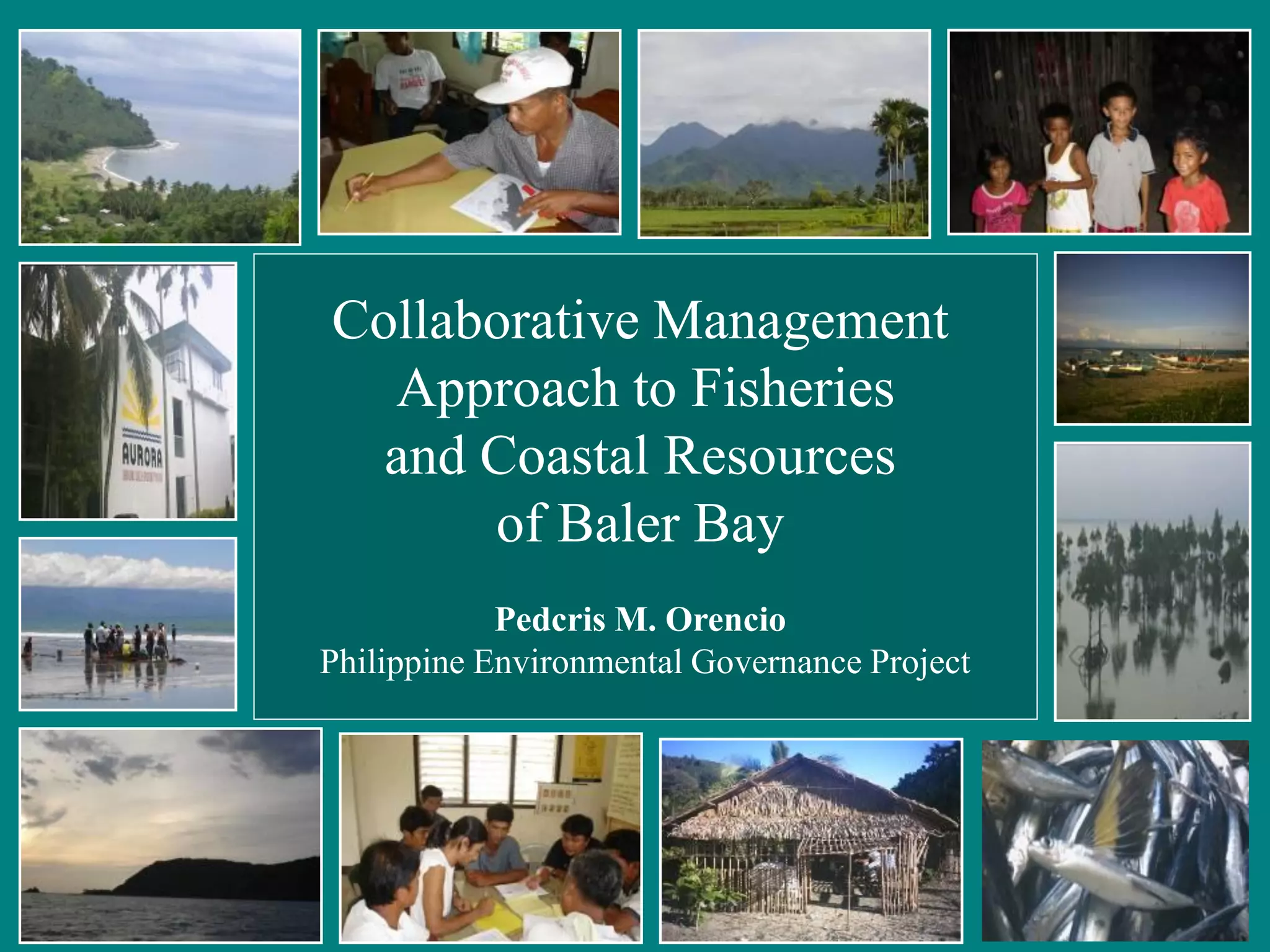
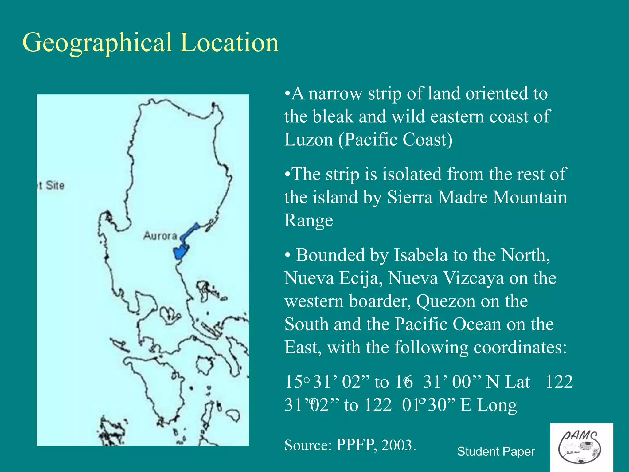
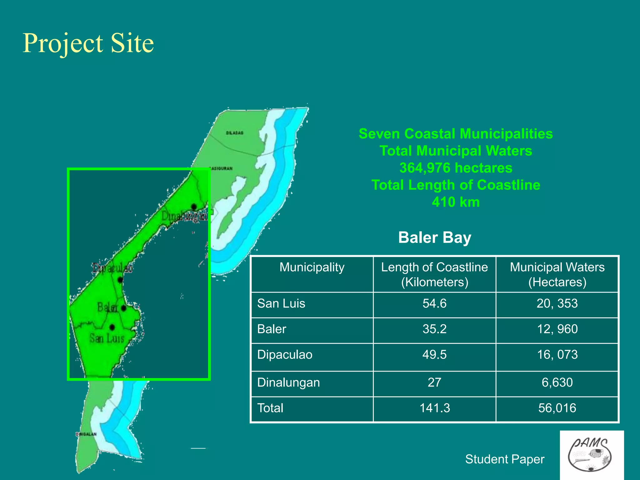
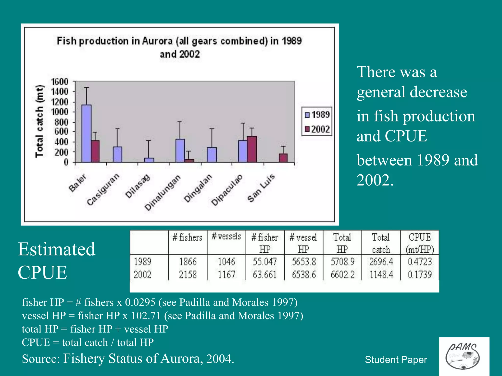
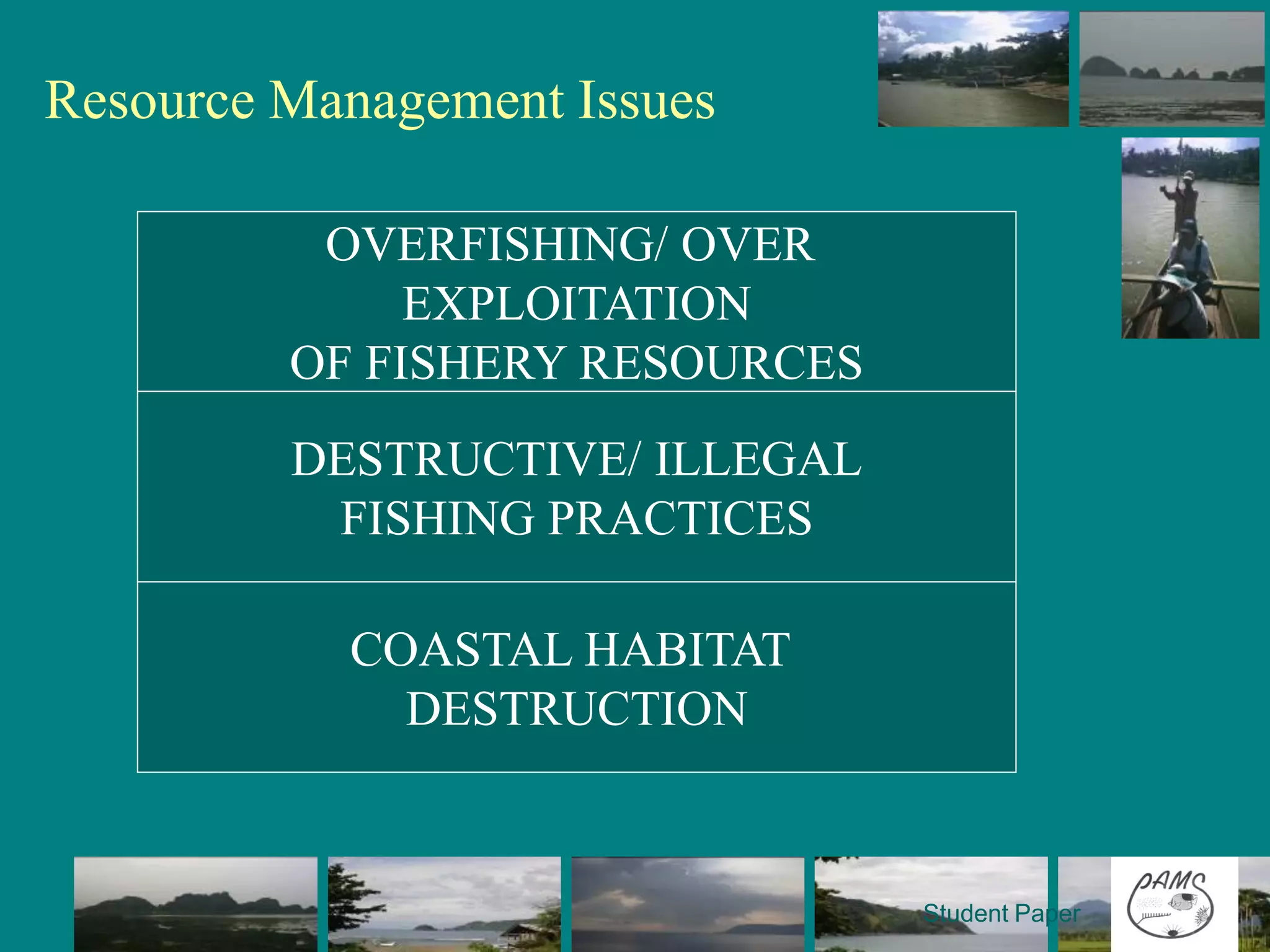
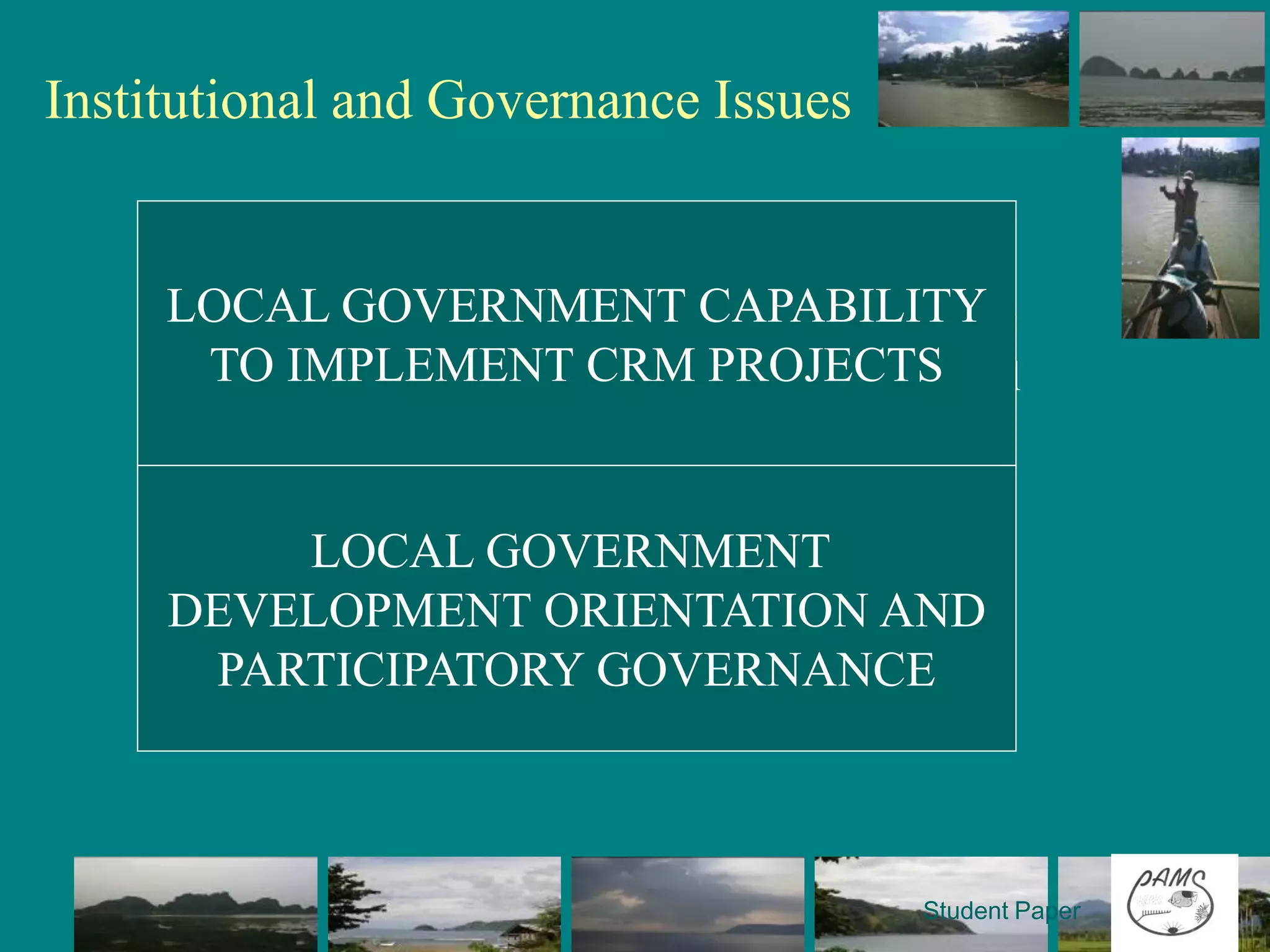
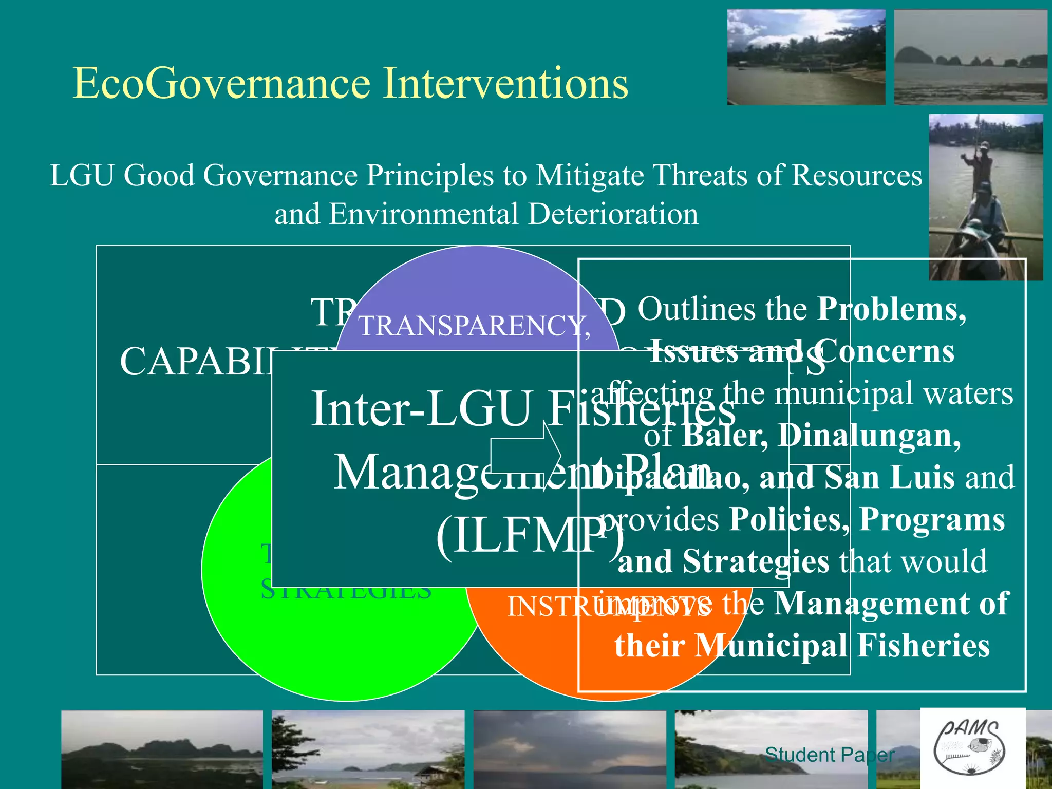
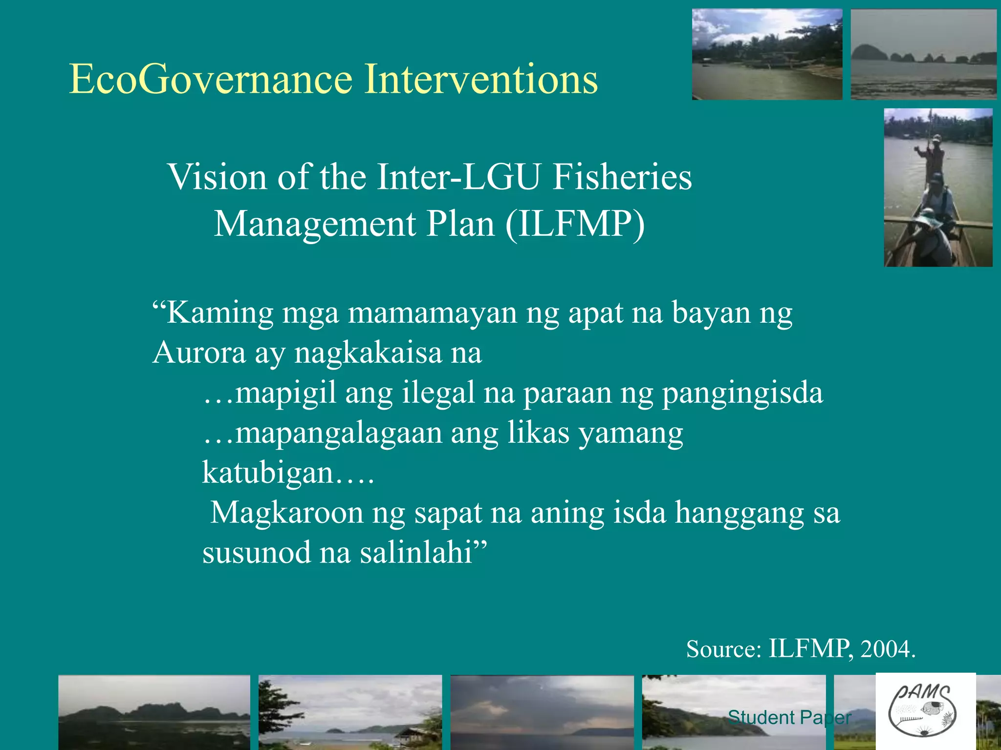
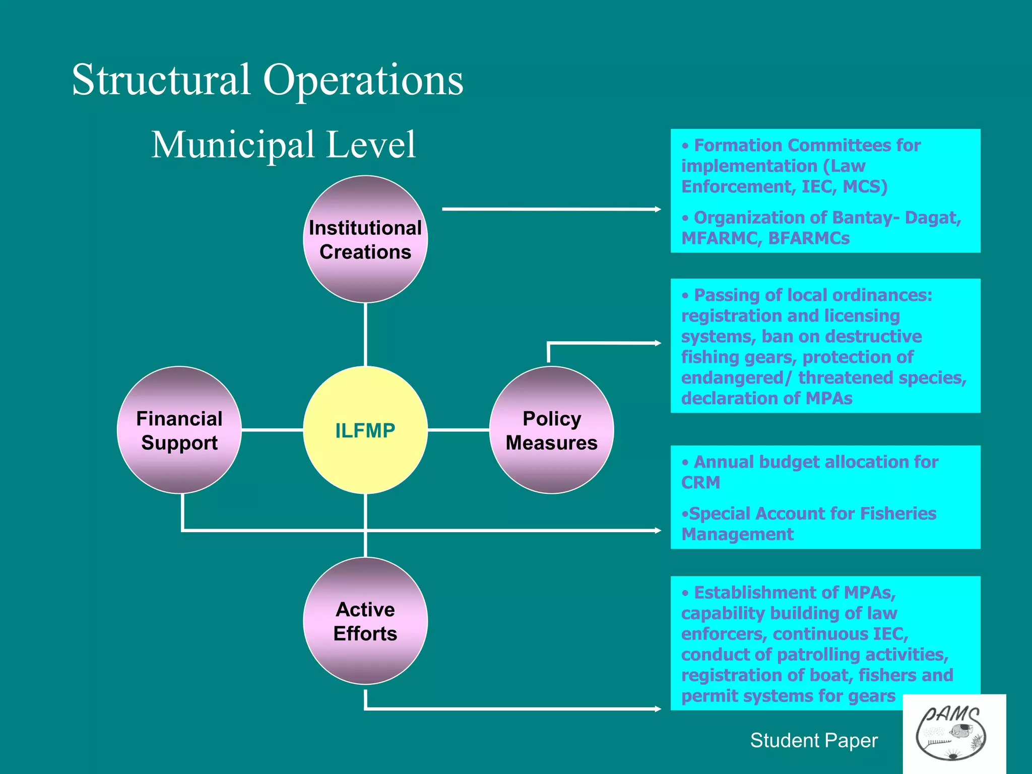
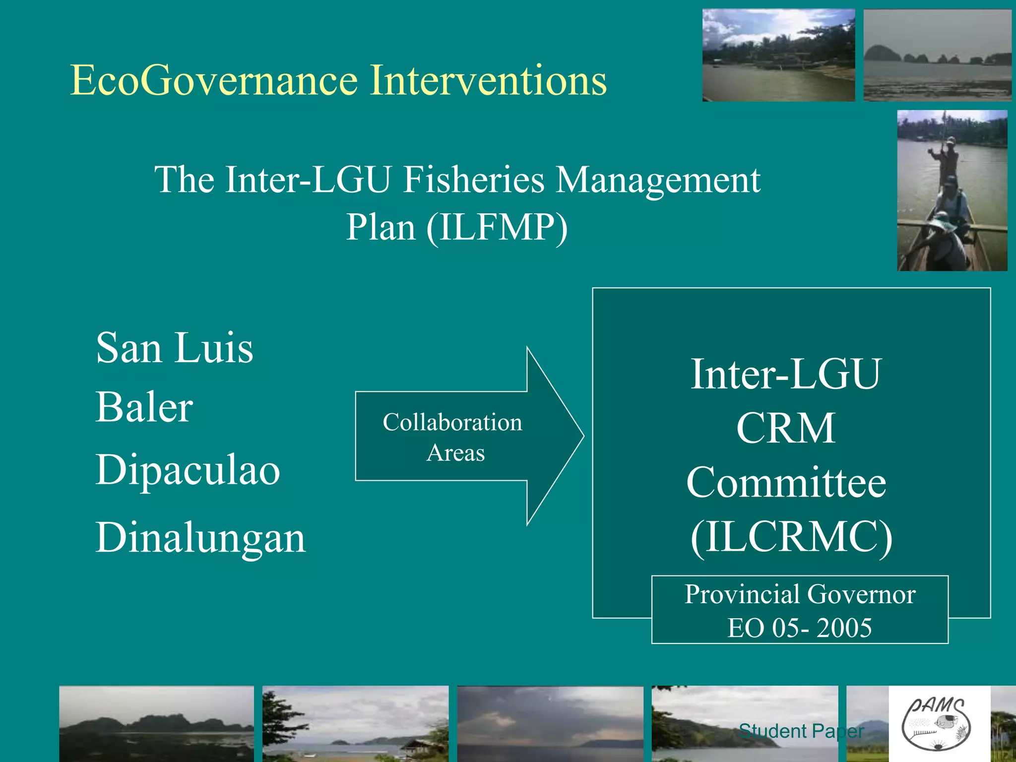
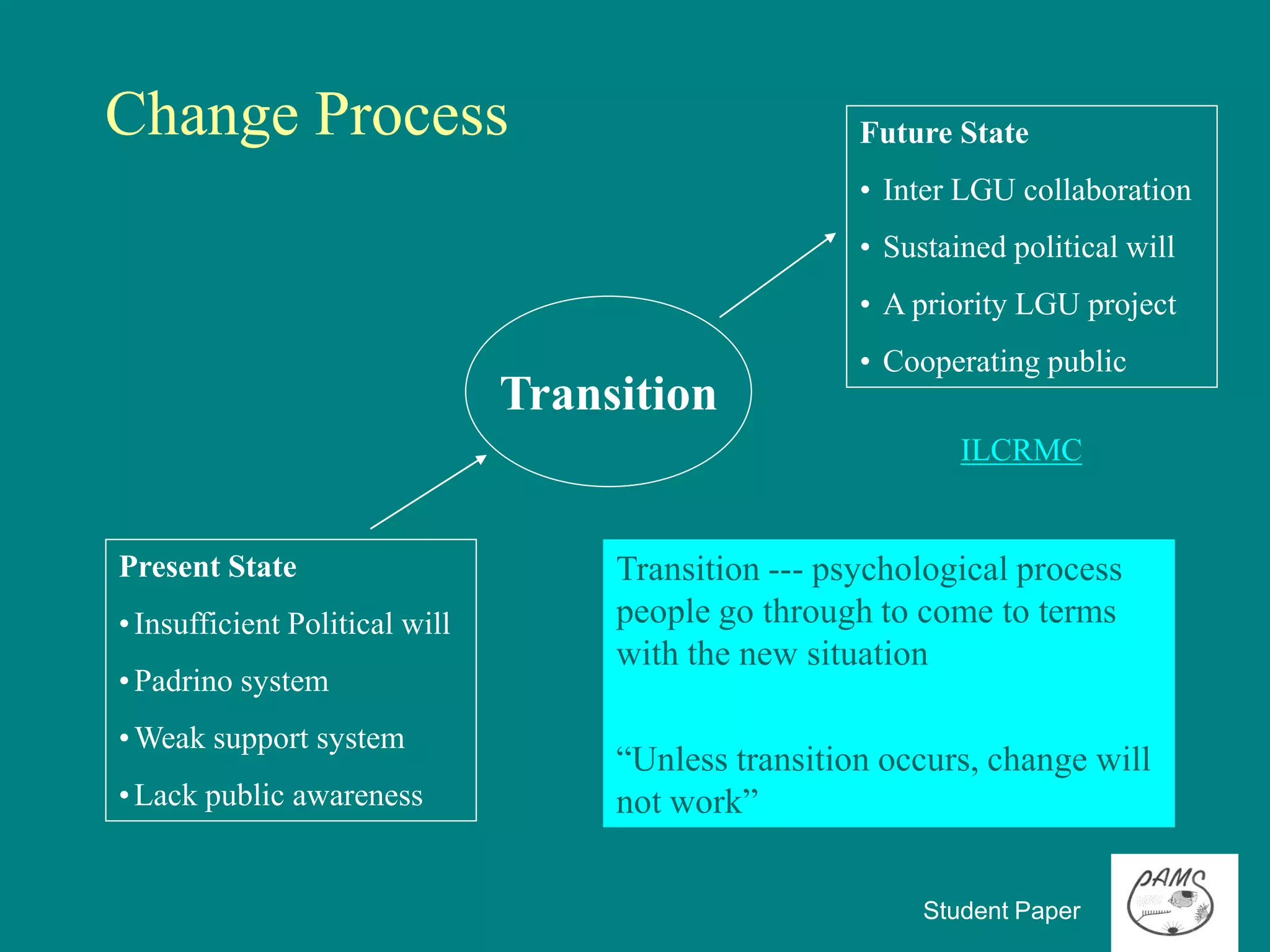
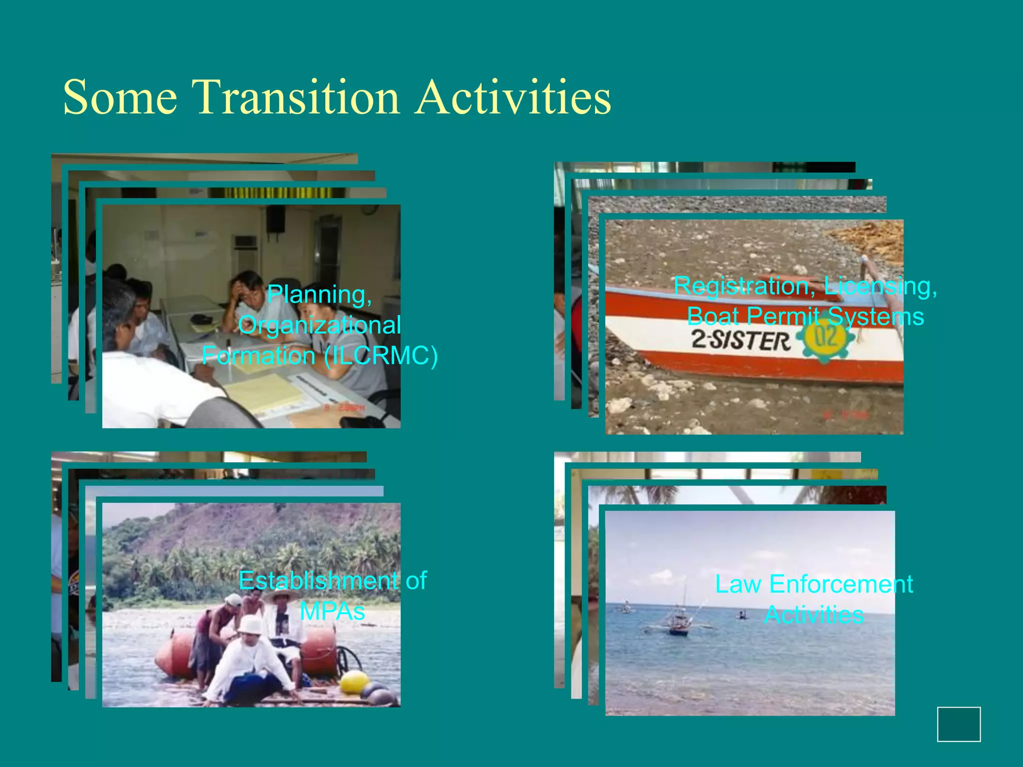
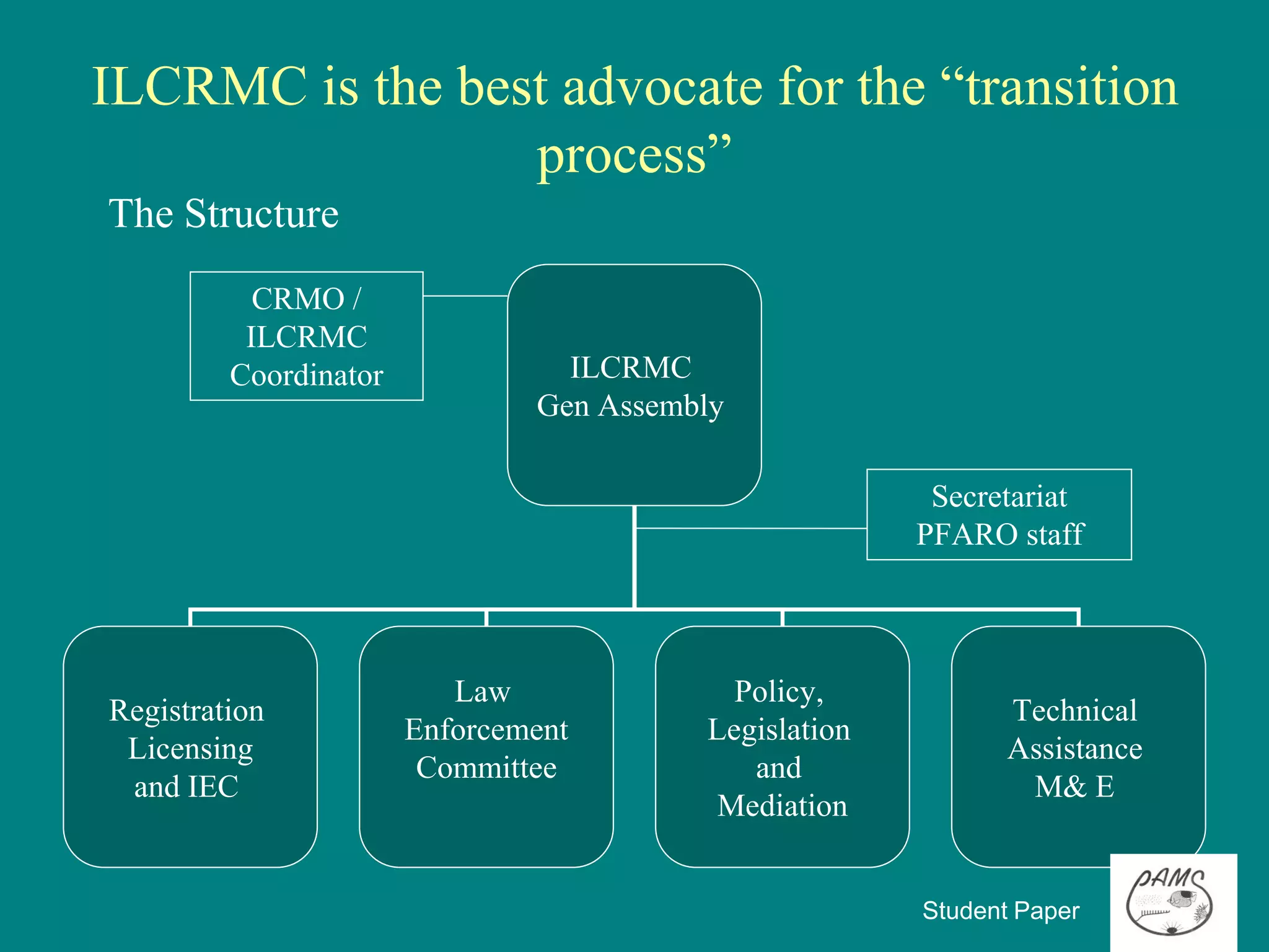
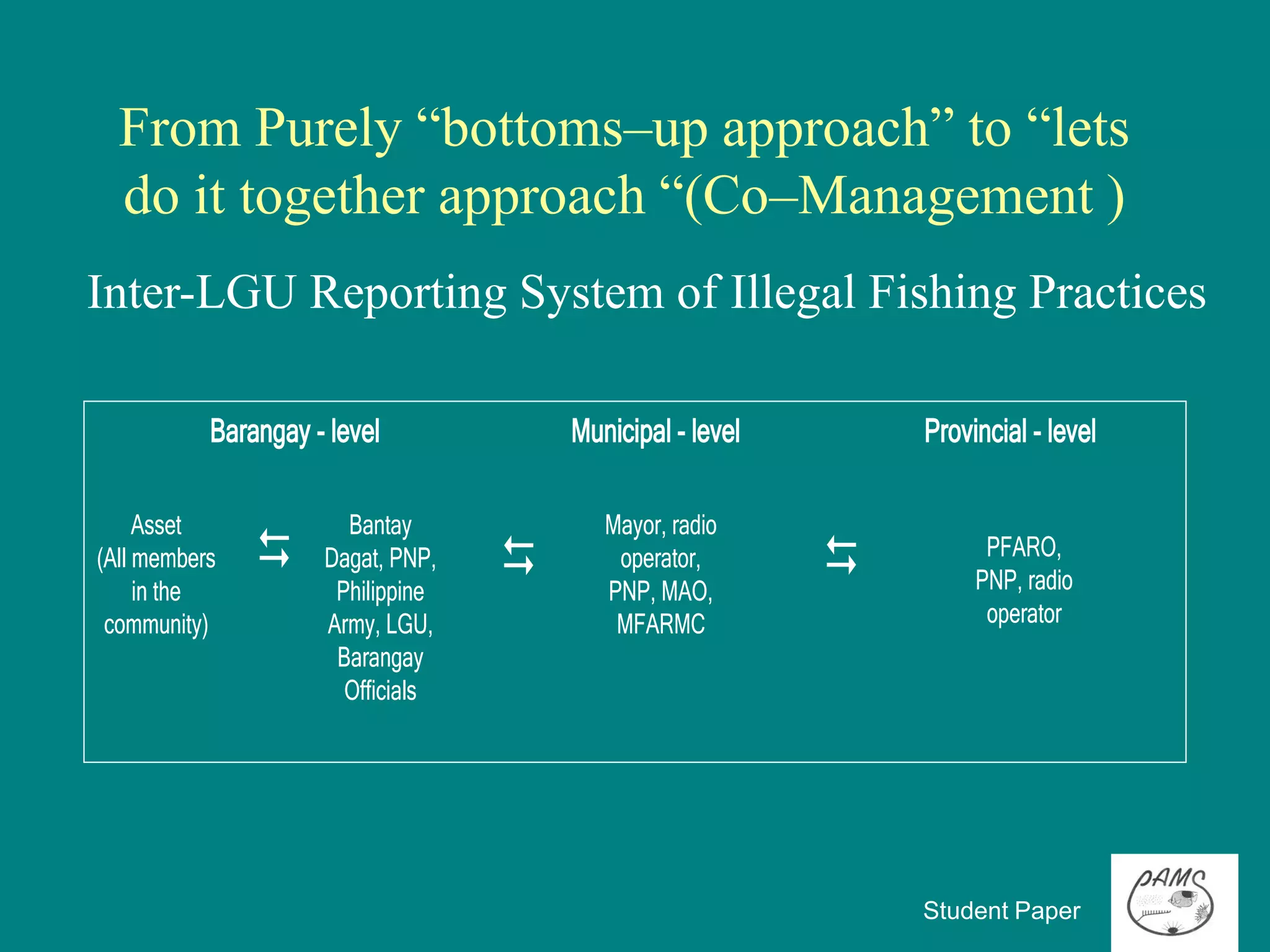
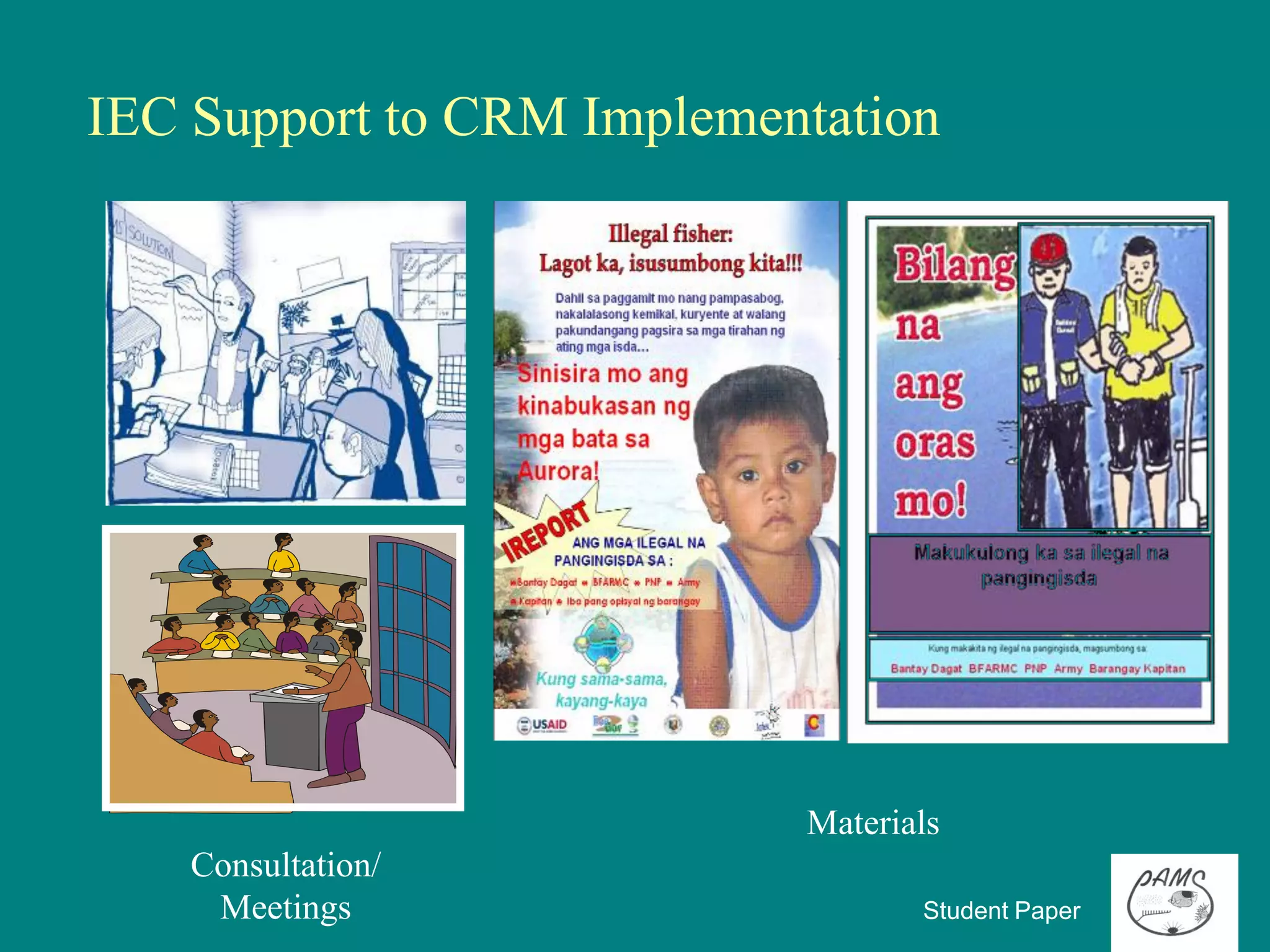
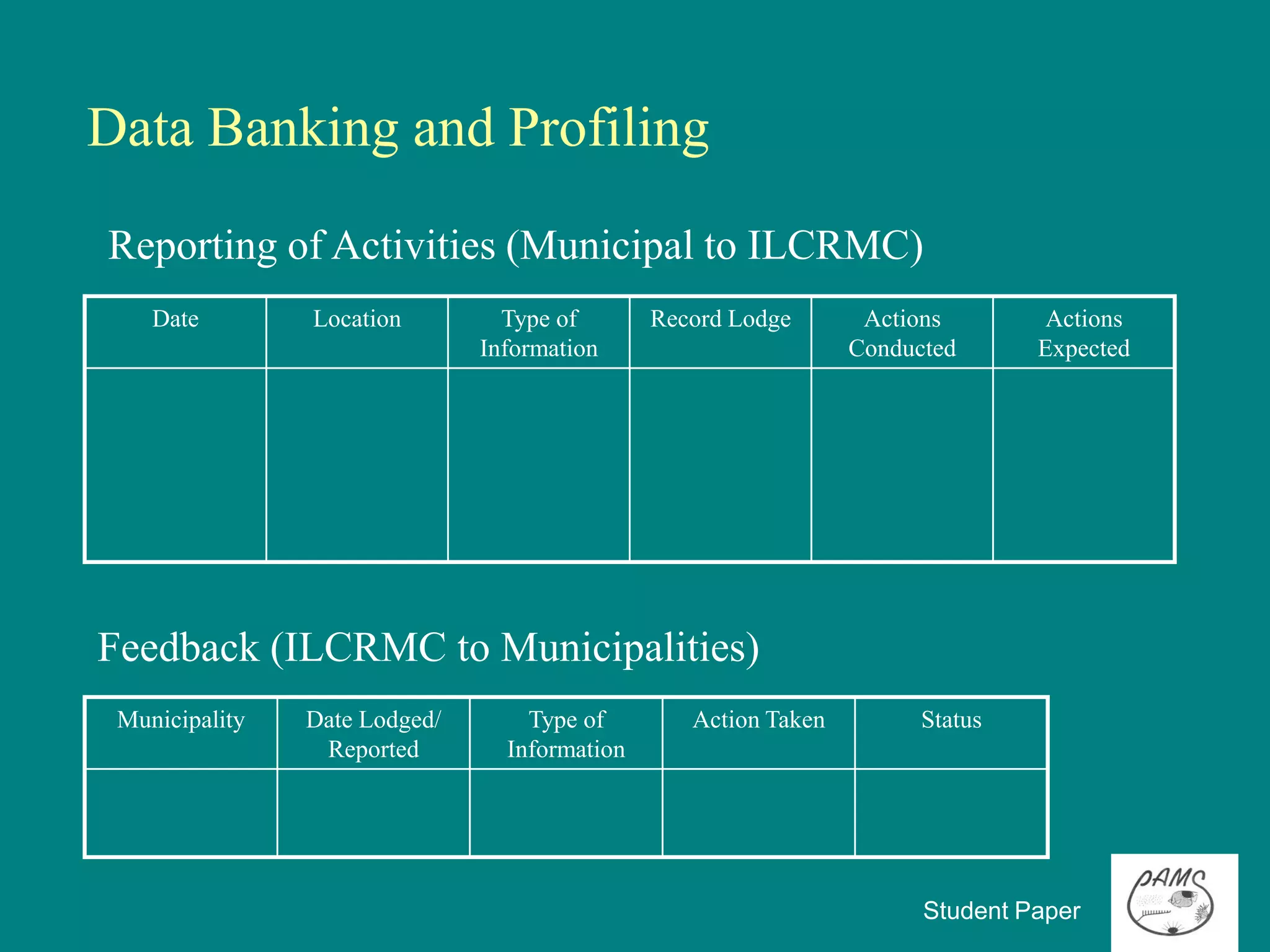
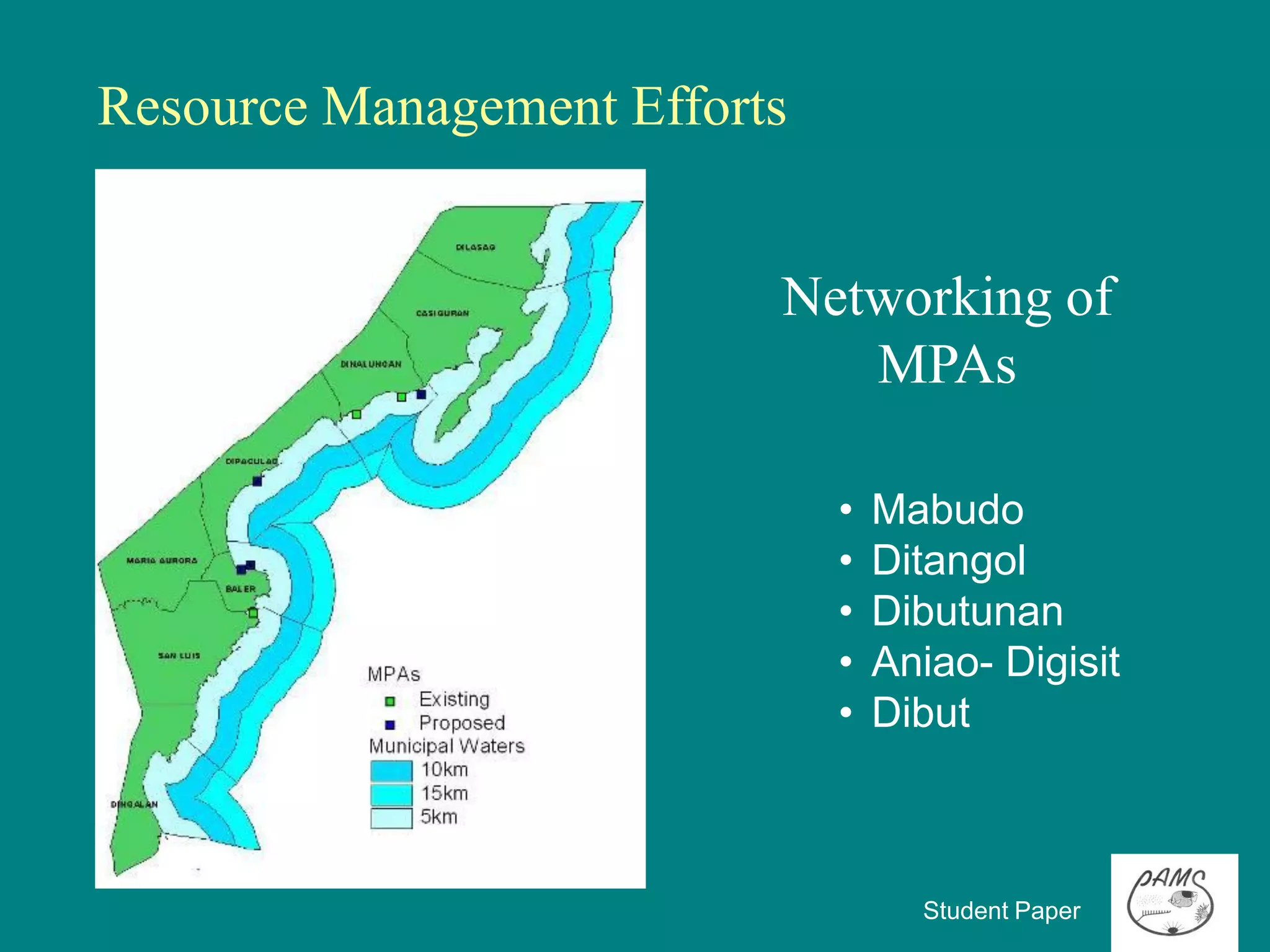
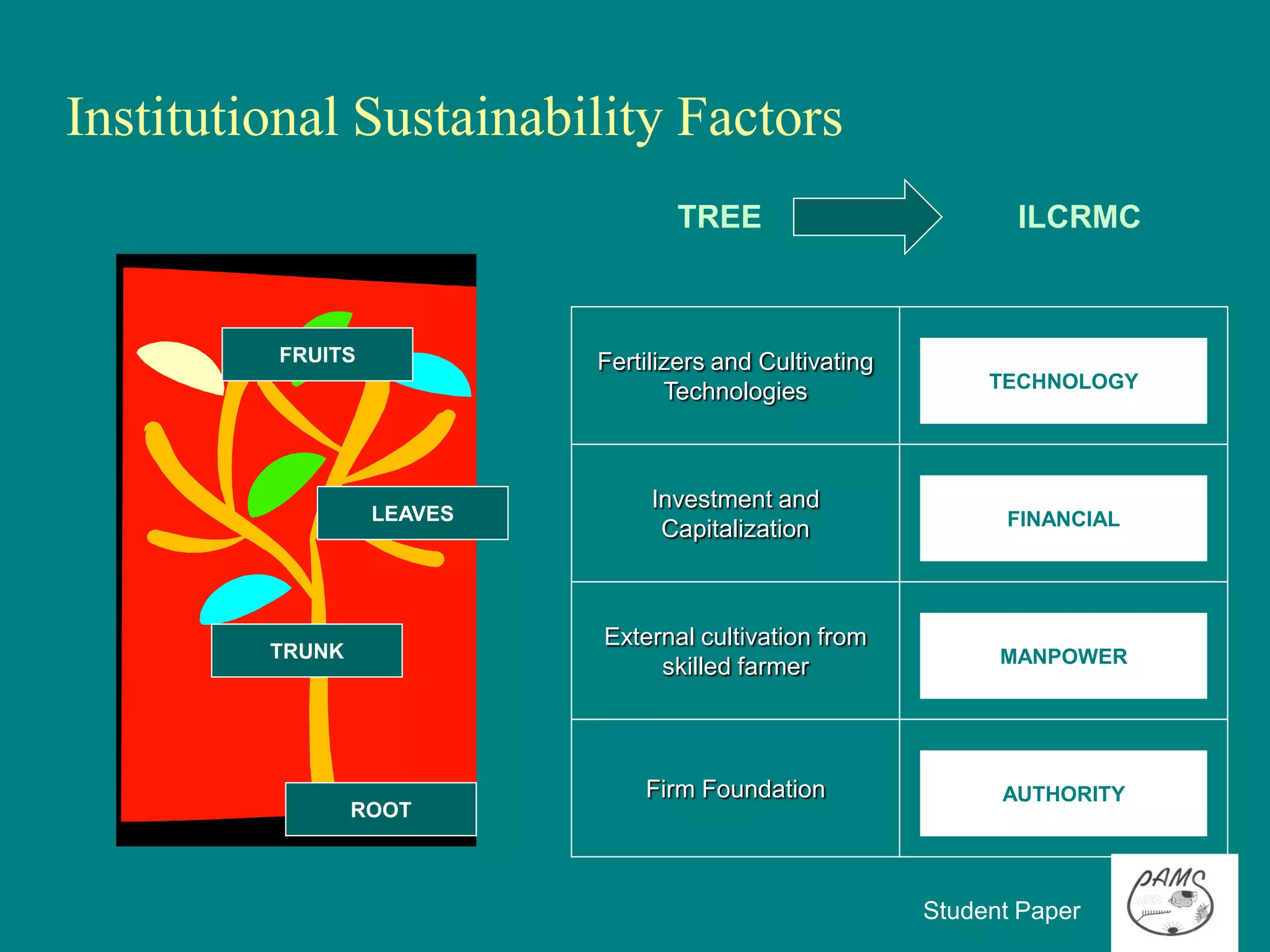
The document summarizes collaborative fisheries management in Baler Bay, Philippines. It describes the geographical location and municipalities within the project site. It identifies issues like overfishing, illegal fishing practices, and coastal habitat destruction. It then outlines interventions like limiting access and stopping illegal practices. The key intervention discussed is an Inter-LGU Fisheries Management Plan to improve management between municipalities through committees, ordinances, budgets, and other active efforts like establishing marine protected areas. The plan aims to transition to more sustainable management through inter-municipal collaboration, political will, and public awareness.
The document discusses an artificial reef project in Tyre, Lebanon. The project aims to promote sustainable development in fisheries and tourism by establishing a marine protected area and artificial reef. It outlines the background of conflicts over marine resources that motivated the project. It then details the objectives, participatory process, financial arrangements, management structure, goals, threats, zoning plans, and guidelines for artificial reef development and monitoring to balance multiple uses and protect the environment.
The document provides an overview of the Saguenay-St. Lawrence Marine Park in Canada. It discusses the park's objectives to conserve biodiversity and ecosystems while allowing sustainable human uses. The park covers 1,245 square kilometers and protects three main ecosystems. It also discusses the history of the park's creation and management challenges related to human activities and climate change on the beluga whale populations in the park.
Overview of the Saguenay-St.Lawrence Marine ParkFrédéric Dufour
The document provides an overview of the Saguenay-St.Lawrence Marine Park in Canada. It discusses the park's history, objectives of conservation, management issues, research activities, and challenges. Key points include its 1245 km2 area protecting three ecosystems, objectives of prohibiting industrial activities while allowing multiple uses, and long history of community involvement leading to its establishment. The park provides an opportunity to study ecosystems and monitor impacts of human activities on the environment.
The document summarizes a conference on GIS and remote sensing applications in Pacific Island countries that was held in Fiji in 2008. Over 150 people from 13 countries attended the conference, which included nearly 50 presentations over 4 days showing how GIS and remote sensing tools are being applied in the Pacific. The conference demonstrated the commitment of Pacific Island GIS users to these technologies and their applications.
This document summarizes CSA's services related to ports, harbors, and beaches. CSA has over 45 years of experience providing environmental services to support marine construction and dredging projects, including port development, dredging, oil and gas terminals, shipping, and beach nourishment. Their services include environmental permitting, surveys of marine habitats, mitigation of impacts to corals and seagrasses, monitoring programs, and working with resource agencies. The document highlights two representative projects involving monitoring of hardbottom habitats near a beach nourishment project in Florida and relocating corals and transplanting seagrasses as mitigation for a dredging project in Miami Harbor.
The document summarizes the activities of the Brasil Surf Pro program in promoting sustainability in coastal ecosystems through surfing events and environmental education. It discusses seminars held in several cities that brought together 340 people to discuss sustainability. Beach cleanups occurred at each event location and collected a total of 940kg of litter. Other activities included releasing rehabilitated sea turtles, a breakfast on sustainable surfing, and planting trees to offset the event's carbon emissions.
The Challenges for the Palawan Biosphere Reserve in Dealing with Climate ChangeNo to mining in Palawan
This document summarizes a forum on climate change held in Puerto Princesa City, Palawan for stakeholders in the province. It discusses the challenges the Palawan Biosphere Reserve faces from climate change, the role of the Strategic Environmental Plan (SEP) and Environmentally Critical Areas Network (ECAN) in regulating resource use and development. It also summarizes the significance of Palawan's forests, beaches, mangroves, and coral reefs to climate change and strategies for mitigation and adaptation being implemented by local institutions and communities.
Marine Spatial Planning Decision Support Tools Development in Canadariseagrant
Canada has committed to integrated ocean management and ecosystem-based management through acts and strategies. Initial integrated ocean management involved broad planning processes but lacked focus on key issues and authorities. New decision support tools are being developed, including pathways of effects models to identify stressors and risks to ecological values from human activities. A risk-based approach will help prioritize management by assessing impacts, establishing conservation limits, and identifying governance needs.
Natural England advises the UK government on designating protected areas and manages some of these areas. They are working to establish an ecological network of protected sites that are larger, more connected, and better able to help wildlife adapt to climate change. Some key programs include Nature Improvement Areas, which provide funding to connect and restore habitats, and marine conservation zones to protect marine environments.
PALAWAN –STATE OF THE ENVIRONMENT 2009 UPDATES
A report by the PALAWAN COUNCIL FOR SUSTAINABLE DEVELOPMENT and The Palawan Council for Sustainable Development Staff (PCSDS) through its Environmental Monitoring and Evaluation System
PCSD Building, Sports Complex Road, Sta. Monica, Puerto Princesa City, Palawan, Philippines
Philippine Copyright @ 2010 by Palawan Council for Sustainable Development, Puerto Princesa City, Philippines
ISBN: 978-971-0475-14-8
www.pcsd.ph
Tel. No. +63 48 434-4235, Telefax: +63 48 434-4234
The document describes a rainwater harvesting demonstration trailer created by University of Florida/IFAS Extension to educate homeowners and contractors about sustainable landscaping, smart irrigation, and rainwater harvesting. The self-contained trailer contains displays of rooftop water collection, rain barrels, cisterns, and irrigation systems. Surveys found that over 500 people who interacted with the trailer were interested in adopting water conservation practices. The trailer has traveled throughout Florida and other states to promote environmental stewardship.
Pontillas, J. Role of UNESCO's Man and Biosphere Reserves in Climate Change A...No to mining in Palawan
The document discusses the role of UNESCO's Man and Biosphere Reserves in climate change adaptation, using the example of Palawan Biosphere Reserve in the Philippines. It provides an overview of Palawan BR, including its characteristics, natural resources, population, and zoning system called ECAN. It describes challenges like deforestation, mining, and climate impacts. Finally, it discusses how ECAN zoning and the biosphere reserve concept can help balance environmental protection and sustainable development in Palawan.
Prasad Modak Presentation at First Multistakholder WorkshopEkonnect
Strategic Action Planning for Revival of Bangalore Lakes outlines challenges facing the city's lakes. Rapid urbanization led to increased land and infrastructure needs, resulting in loss of forest cover. Untreated sewage, waste and industrial runoff pollute lakes. Encroachments changed land use and interrupted connecting channels. A coordinated, long-term strategic plan is needed to address issues from a watershed perspective using modern tools. Community involvement and innovative financing models are crucial for conservation.
This study used GPS and ethnographic techniques to document human encroachment on nesting habitat for olive ridley sea turtles on beaches in Nuevo Vallarta, Mexico that are experiencing rapid coastal development. The researcher mapped human structures, drainage systems, and areas of contamination to quantify habitat loss. Analysis found that 27.67% of the originally protected coastal zone was occupied by human development, leaving less available nesting area. Nest distribution was uneven along the beach, with some sections receiving over 100 nests compared to others receiving only 1, highlighting important nesting hotspots.
This presentation was given as part of the EPA-funded Catchment Science and Management Course focusing on Integrated Catchment Management, held in June 2015. This course was delivered by RPS Consultants. If you have any queries or comments, or wish to use the material in this presentation, please contact catchments@epa.ie
It is increasingly being recognised internationally that integrated catchment management (ICM) is a useful organising framework for tackling the ongoing challenge of balancing sustainable use and development of our natural resource, against achieving environmental goals. The basic principles of ICM (Williams, 2012) are to:
• Take a holistic and integrated approach to the management of land, biodiversity, water and community resources at the water catchment scale;
• Involve communities in planning and managing their landscapes; and
• Find a balance between resource use and resource conservation
ICM is now well established in Australia, New Zealand, and the United States. In Europe the ICM approach has been proposed as being required to achieve effective water and catchment management, and is the approach being promoted by DEFRA for the UK, where it is called the “Catchment Based Approach” (CaBA). The principles and methodologies behind ICM sit well within the context of the Water Framework Directive with its aims and objectives for good water quality, sustainable development and public participation in water resource management. In Ireland it is proposed that the ICM approach will underlie the work and philosophy in developing and implementing future River Basin Management Plans.
The document summarizes a report on the Mamanuca Coral Reef Conservation Project conducted in Fiji in 2001. The project aimed to assess the health of local reefs and improve environmental awareness. Surveys found widespread impacts like coral bleaching had degraded the reefs. A habitat map showed that reef habitats covered only 70 km^2 of the 1826 km^2 project area. Most sites were in poor condition with low coral cover. The project recommends expanding marine reserves to 20% of reefs to protect biodiversity and fisheries while reducing threats to reef health.
Salt River Bay Marine Research and Education Centermichaelsbayer
The document provides an overview of the Salt River Bay Marine Research and Education Center (MREC) project. The MREC will be a world-class, sustainable facility serving partners through marine research and Caribbean studies programs. It will demonstrate green building and sustainable energy technologies while showcasing "research in a park" and environmental education programs. The MREC brings together the Department of the Interior, National Park Service, Government of the Virgin Islands, and four university partners through the Joint Institute for Caribbean Marine Studies to establish a marine research lab and further understanding of tropical marine ecosystems.
Clean Rivers, Clean Lake 8 -- Ozaukee County Fishway -- Andrew StruckSweet Water
This document summarizes a program to restore fish passage in the Milwaukee River watershed. The program removed barriers like dams to reconnect over 37 river miles and 33 tributary miles of habitat. Barriers ranged from large mainstem dams to small debris jams. Removal projects included dam removals and construction of nature-like fishways. Monitoring found increased presence of target species like northern pike in reconnected areas. The program enhanced ecological connectivity while creating jobs and stakeholder partnerships across the watershed.
This document provides information about NAVFAC Pacific's natural resources program and staff. It includes:
- A list of NAVFAC Pacific's areas of responsibility and bases within different regions.
- Contact information for the leadership of NAVFAC Pacific's Environmental Planning and Conservation division.
- Rosters of the Terrestrial Natural Resources and Applied Biology staff, and Marine Resources staff, with names, emails, and phone numbers.
- Brief descriptions of the types of projects and activities the Terrestrial Natural Resources group undertakes, such as ESA consultations and implementing Integrated Natural Resources Management Plans.
- Examples of successes in translocating endangered tree snails during the Marine Corps
Palawan is a biodiversity hotspot in the Philippines home to many endemic species. However, its biodiversity is threatened by 354 approved mining applications covering much of the island. Mining risks damaging Palawan's forests, water sources, and ecosystems which could harm its thriving ecotourism industry. While the law aims to protect Palawan's environment, many feel mining poses too many risks and its economic benefits are limited. The article examines the history of mining in Palawan and its potential environmental and social impacts.
The document introduces several natural resources experts within NAVFAC Atlantic including their areas of expertise. It then describes the various natural resources support services provided including environmental compliance, surveys, training and more. Finally it outlines some specific projects supported and cooperative agreements maintained to aid natural resources programs across installations.
The document summarizes preliminary results from the FLOOD-WISE project, which aims to improve flood risk management in transboundary river basins. It discusses obstacles to transboundary cooperation, achievements on several rivers including developing common models, maps, and flood risk management plans. Key results were an open platform sharing best practices, a serious game about cooperation, and six flood risk management plans presented at a final conference, along with recommendations to facilitate transboundary flood risk management.
US Fleet Forces Environmental ReadinessBryanHall58
The document discusses the United States Fleet Forces' environmental readiness programs, which include monitoring marine species and their responses to Navy training activities, conducting research on topics like marine mammal tagging, and ensuring compliance with environmental laws for actions like home basing and expanding aircraft operations. Key programs mentioned are the Integrated Comprehensive Monitoring Program, the Behavioral Response Study on beaked whales and pilot whales, and pinniped tagging in the Chesapeake Bay area.
Resources Analysis - Province of Palawan, Impacts of Macroeconomic Adjustment...No to mining in Palawan
IMAPE Project
Philippines
Impacts of Macroeconomic
Adjustment Policies on the
Environment Project
IMAPE Research Paper No. 08
Resources Analysis, Province of Palawan
Provincial Planning and Development Office
Province of Palawan
October 2001
This work was carried out with the aid of a grant from the International Development Research Centre, Ottawa, Canada.
IMAPE Project. Policy and Development Foundation, Inc.
Unit 7B Vernida I Condominium, 120 Amorsolo Street, Legaspi Village, Makati City, Metro Manila Philippines
Telephone: (632) 813-6178/79 Fax: (632) 813-6179
Email: mimap@pacific.net.ph
This document provides an overview of Commander Navy Region Northwest's natural resource management programs across 4 installations and 16 reporting units. It summarizes that they manage over 66,000 acres of ecosystem, including federally-listed and species of concern. Key programs include habitat management, forestry, fire control, hunting/fishing, and invasive species control. Recent accomplishments include aquatic habitat restoration, estuary mitigation, and surveys of species like marbled murrelets. Lessons learned include changes to acoustic thresholds in consultations and linking natural resource projects more closely to installation missions.
Coastal and Marine Environment Protection
International Roundtable on Protection and Sustainable Use of Trans-boundary Waters in South East Europe, 15-16 December 2011, Zagreb, Croatia
The document discusses the origin and evolution of life on Earth. It describes how early experiments in 1953 simulated lightning and the early atmosphere, producing amino acids. It also discusses how life may have begun in alkaline hydrothermal vents on the early ocean floor. Coral reefs formed after the last ice age as sea levels rose and flooded continental shelves, allowing reef ecosystems to develop.
This document summarizes Philippine laws related to fisheries, organized in a hierarchy. The Philippine Constitution establishes ownership and protection of natural resources including fisheries. National laws include the Fisheries Code and laws on protected areas. International treaties become law once ratified. Executive orders and administrative orders implement laws. Local governments supplement but cannot contradict national laws through ordinances. Specific fisheries administrative orders from the Department of Agriculture regulate fishing gears and practices.
The Philippine fisheries industry plays an important role in the economy and food security of the Philippines. It provides livelihood for over a million Filipinos and accounts for around 5% of the country's GDP. However, overfishing and illegal fishing threaten the sustainability of fisheries resources if not properly managed.
The document provides an overview of coastal management in the Philippines. It discusses that local government units have broad powers over coastal environments through devolution. It notes the fragmented governance with over 20 government units managing different coastal sectors. Key issues include a lack of integrated management, weak enforcement, and limited institutional and local capacities for coastal management. Emerging arrangements include partnerships between local and national agencies to better manage resources. The document concludes with discussing the first marine protected area established in Sumilon Island in 1974.
The document discusses Philippine laws related to fisheries and natural resources. It begins by outlining the hierarchy of laws, with the Constitution at the top, followed by national laws, international treaties, executive orders, and administrative orders from agencies like the Department of Agriculture. It then summarizes several key provisions in the Constitution related to natural resources and fisheries. Finally, it lists numerous national laws, international treaties, and executive and administrative orders that provide legal framework for managing fisheries and protecting the environment in the Philippines.
This document discusses ecosystem approach planning to build adaptive local coastal communities that are resilient to climate change effects. It focuses on a case study in Aurora Province, Philippines, which has extensive coastal ecosystems and fisheries that are important for livelihoods. The ecosystem approach considers all species and uses participatory decision making. Assessments show overfishing is depleting resources in the province. Climate change is exacerbating risks like sea level rise, more intense storms, and changing seasons. Strategic actions proposed include coastal zoning, habitat protection and restoration, sustainable fisheries management through enforcement and regulations, and post-harvest support. Local governments are well-positioned to address causes and effects of climate change through policies, social capital, and inter
This document provides information on mangroves in Pangasinan province, Philippines. It details that there are 469 hectares of existing mangrove area across 13 coastal municipalities. A mangrove nursery produces 80,000-100,000 seedlings annually of 12 mangrove species. Over 300,000 seedlings have been planted since 2008 across 51 hectares of coastal area and 87 km of riverbanks. Partnerships with various organizations support mangrove reforestation and community education. Studies show enhanced fish catches and storm protection benefits from reforested mangrove areas. The program has received several awards for its coastal management.
The document discusses climate change impacts on fisheries and aquaculture in the Caribbean region and recent initiatives to address these issues. It outlines key challenges like rising sea levels, changing weather patterns, and damage to coral reefs from warming oceans. Recent regional projects aim to build climate resilience in fishing communities through activities like developing early warning systems for fishers of weather threats and establishing a regional fisheries risk insurance fund to incentivize climate-smart practices. The document also discusses partnerships and opportunities to scale up best practices to increase adaptation efforts across the Caribbean.
The Awik-awik: Revitalization of Rights-based Fisheries in Jor Bay, East Lomb...FAO
This document summarizes efforts to revitalize traditional fisheries management in Jor Bay, Indonesia.
[1] The area was experiencing overexploitation, pollution, low incomes and conflicts between different user groups. [2] A participatory approach was used to establish a new "Awik-awik" system to co-manage the fishery and define rules for sustainable use. [3] Additional initiatives included mangrove planting, installation of squid attractors and fish aggregating devices, and livelihood training to support the new management system's implementation and balanced ecosystem use.
Working at the public-private interface to improve the outlook for coral reefsDr Adam Smith
Coral reefs face mounting challenges, with many reef ecosystems now in the worst condition since scientists first donned diving masks. Redoubled efforts in climate change mitigation and ecosystem management, characterized by scaled-up investments, innovation, capacity building and greater participation by community and private sectors are all required if we are to give reefs the best chance of surviving this era of rapid global change. Reef Ecologic was established as a non-government organization to facilitate public-private partnerships necessary to address the challenges of contemporary coral reef management and sustainable development. In this seminar we will provide an overview of some of our recent work in Australia and overseas that will be of interest to staff of the GBRMPA, including coral bleaching surveys, tourism infrastructure assessments, assisted reef recovery at Magnetic Island, code of practice for recreational fishers, the Reef Manager’s Guide to Fostering Community Stewardship, management and leadership training for coral reef managers and strategic advice for Reef Trust investments.
This document summarizes climate change adaptation strategies for Pacific fisheries and aquaculture. It notes that fisheries and aquaculture are important for food security, livelihoods, and economic development in Pacific island countries. Climate change is projected to impact ocean currents, sea level rise, and weather patterns in the Pacific, which will affect fish production, ecology, and fishing/aquaculture operations. Some recommended adaptation strategies discussed include diversifying fishing activities, improving post-harvest techniques, incorporating climate change into policies and development plans, using ecosystem-based fisheries management, and reducing risks through disaster risk management and protecting natural barriers. The FAO is working to support countries in developing climate change adaptation plans and projects focused on the agriculture
From IUU forward: Better Fishing Practice for Mixed Bottomfish Fisheryfishersforum
This document summarizes Sea Delight's efforts to improve sustainability practices in a mixed bottomfish fishery in Central Sulawesi, Indonesia. It describes working with WWF to identify issues like illegal fishing methods and engage stakeholders. Sea Delight now has policies against practices like blast/cyanide fishing and trade of endangered species. Supply chain participants were identified and logbook systems track landings. While fishing pressure views differ, continued data collection and management may help determine fishery status.
2012 08 The Work of the Devon and Severn Inshore Fisheries and Conservation A...SevernEstuary
Tamsyn Noble - Devon & Severn IFCA
The Work of the Devon and Severn Inshore Fisheries and Conservation Authority in the Severn
Tamsyn Noble is the recently appointed Senior Environment Officer for Devon and Severn Inshore Fisheries Authority (IFCA). Based in Bristol, Tamsyn is primarily responsible for the delivery of IFCA research objectives within the Severn area, having established survey programmes to assess the availability and use of sea fisheries resources, and habitats of conservation significance. Tamsyn graduated with a BSc (Hons) in Marine Biology and Coastal Ecology in 2005, before undertaking voluntary work in a variety of marine ecosystems, both in the UK and abroad. Following graduation from MSc Applied Ecology and Conservation in 2009, Tamsyn was recruited to the role of Marine Environmental Scientist in the offshore energy sector. During this period she worked both onshore and offshore to deliver environmental baseline and monitoring projects, and specialised in the assessment of Annex I habitats.
Devon and Severn Inshore Fisheries and Conservation Authority (D&S IFCA) was fully vested in 2011 under the Marine and Coastal Access Act 2009, to provide inshore fisheries and conservation management, with an increased focus on habitats and ecosystems. The district boundary of the IFCA, which previously encompassed only the Devon coastline to six nautical miles, was substantially increased to include the Severn Estuary and Inner Bristol Channel. Following establishment of a presence in the Severn area of the district, a programme of research activities has commenced, aiming to determine the extent of commercial and recreational use of its marine resources and habitats. This presentation will focus on the role of the IFCA within the Severn area, introducing key current and future research areas, and presenting preliminary data on recreational activities.
Ripples of Hope over Troubled Waters:
The Calancan Bay Experience
SEARCA Monograph Series 2002-2
Francisco P. Fellizar, Jr.,
Wannah Maria Ayesha H. Velo,
Robert G. Bernardo
The Code of Conduct for Responsible Fisheries (CCRF) was adopted by FAO in 1995 to promote sustainable fishing practices. It provides principles and standards for the conservation, management, and development of fisheries. The CCRF recognizes the importance of fisheries for food, jobs, trade, and economic benefits. It encourages states and fisheries stakeholders to apply the Code to ensure responsible practices now and for future generations. The FAO aims to support implementation through projects, meetings, and calls for collaboration to fully achieve the CCRF's goals.
The document discusses rebuilding depleted fish stocks in Ghana through sustainable fisheries management. It outlines the Coastal Resources Center's portfolio and work with Ghanaian communities to tackle issues like overfishing. Their goal is to establish healthy, well-planned coasts and thriving, resilient communities through projects that promote safe, sustainable seafood and empower citizens. One of their key projects involves working with communities in Ghana to rebuild depleted fish stocks through community-based management and other interventions.
The document outlines a lecture on coastal resource assessment and management in the Philippines. It discusses the importance of coastal resources, participatory coastal resource assessment (PCRA), and different monitoring methods used in PCRA like manta tow surveys, transect surveys, and fish visual censuses. These methods are used to collect data on coastal habitats, fisheries, and socioeconomic factors to identify issues and inform management guidelines. The lecture aims to familiarize participants with PCRA and apply participatory methods in an actual coastal assessment.
The 4-year C-FISH initiative aims to improve management of 15 no-take marine protected areas (MPAs) across 6 Caribbean countries to promote sustainable livelihoods and increase coastal resilience to climate change. Funded by UKAID, it is implemented by CARIBSAVE and supports MPA management through capacity building, alternative livelihood programs, research, and communication. Key objectives include facilitating stakeholder participation, monitoring effectiveness, and raising awareness of MPAs' environmental, social and economic benefits in the Caribbean.
Development of an Indonesian Sea Grant Partnership ProgramOregon Sea Grant
Indonesia's Sea Partnership Program (SPP) provides a mechanism for addressing gaps in marine resource management at central and regional levels. SPP matches national strategic priorities with regional development issues through partnerships between regional universities, local governments, NGOs, and the private sector. The program was established in 2002 and had expanded to involve over 86 universities, 39 private institutions, and 77 NGOs across 33 provinces by 2010.
This document discusses broadcasting eco-fishing in Ethiopia. It provides background on key concepts like the environment, aquatic ecosystems, fisheries, and fish. It then examines Ethiopia's fish resources, production trends, main fish species, fishing gears, and the contribution of fisheries to development objectives like income, food security, poverty alleviation, and public health. Finally, it outlines challenges facing fisheries management in Ethiopia like lack of awareness, data, and trained personnel, as well as recommendations to address these issues through education, research, sustainable practices, and cooperation.
Similar to Collaborative Fisheries Management (20)
Spatiotemporal Assessment of Disaster-risk PotentialPed Orencio
This document summarizes a 30-year qualitative multi-hazard assessment conducted to determine coastal areas in the Philippines that are at high risk. The assessment characterized hazards based on historical data and estimated probability and impact to calculate risk potential at the provincial level. The study found that Aurora province has the highest overall risk potential among coastal provinces. It also identified several implications of the risks identified, including higher per capita costs in densely populated areas and risks for provinces with mismanaged forests or watersheds. Next steps suggested validating the results with a case study and using the risk information to devise concrete risk mitigation and communication strategies.
Disaster-resilience Index based on an Analytic Hierarchy ProcessPed Orencio
This document describes developing a composite index to measure the resilience of coastal communities using an analytic hierarchy process (AHP) model. Criteria and attributes that describe resilient communities and risk reduction were determined through an AHP survey of 20 decision-makers. The most important criteria selected were environmental management, livelihoods, social protection, and planning. A framework was created using these criteria and indicators to measure community capacity and outcomes. A weighted linear method was used to calculate a composite index score based on process and outcome indicators. The proposed conceptual method provides a way to assess and inform coastal community resilience and risk reduction planning.
This document summarizes a perspective on the sustainable palm oil industry in Central Kalimantan, Indonesia over the next 30 years. It outlines the growth of palm oil production in the region from 2000-2006. A SWOT analysis identifies strengths, weaknesses, opportunities and threats. The vision is for a responsible palm oil industry that is environmentally friendly, economically sound, and socially acceptable. Strategies are proposed for government, industry and society to work together transparently towards this vision through initiatives like Publish What You Pay and Produce, strengthening government oversight, the Roundtable on Sustainable Palm Oil certification, and establishing a Palm Oil Industry Board.
Climate change is affecting coastal ecosystems and fisheries through changes in temperatures, currents and weather patterns. This impacts organisms and communities. The document examines these climate impacts in the Philippines province of Aurora through analysis of coral cover, fish abundance, biomass and sea surface temperature data from 2003-2006. The results suggest climate change has contributed to declines in coral cover and fish stocks in the area.
The document outlines information about several sustainability conferences hosted by universities around the world, including the host university, theme, participants, and outputs. The conferences focused on topics like energy, climate change, consumption, and generating solutions through workshops and discussions. Participants collaborated to develop proposals and recommendations to submit to organizations like the G8 summit and UNFCCC on issues related to sustainable development, energy, and the environment.
This document discusses the challenges of addressing climate change while also promoting development and reducing inequality and poverty. It notes that [1] expanding access to energy for development will increase emissions, conflicting with climate policy, and [2] there is not enough remaining carbon budget for all poor countries to develop through high-emission paths as wealthy countries have. It proposes [3] quantifying an equitable framework for allocating emission reductions based on principles of responsibility and capability, with developed countries committing major domestic cuts and support for international climate efforts.
The document summarizes the community-level disaster response system in the Philippines. It notes that the Philippines experienced 24 natural disasters in a year, making it the hardest hit country. It then discusses the prevailing view that disaster management has not been a high priority for the Philippine government and responses have been reactive. However, communities developed coping mechanisms and citizen-based approaches to disaster management. The document advocates transforming communities from risk to resilience by building capacity and supporting people's organizations through networking and experience sharing.
This document describes using ArcGIS Geostatistical Analyst to interpolate precipitation and temperature data from monitoring stations in Hokkaido, Japan. It discusses interpolation methods, analyzes seasonal trends in precipitation and temperature using kriging, and overlays the results to understand spatial relationships. The analysis helps establish climatic trends and identify areas of higher and lower precipitation and temperature.
A bottom-up approach to climate mitigation for developing countries may have advantages over a top-down approach. Top-down approaches based on emission caps could incentivize setting overly high targets or delaying early action. They may also reduce predictability of emission levels and reductions compared to business-as-usual baselines. Bottom-up approaches like Nationally Appropriate Mitigation Actions strengthen domestic institutions in developing countries, which is important for successful low-carbon development programs but underemphasized in top-down approaches.
- The document discusses vulnerability in coastal communities in the Philippines. It focuses on 5 coastal villages in Baler, Aurora that are rich in resources but threatened by natural hazards and have poor social conditions.
- Two composite index frameworks are constructed to determine factors that affect coastal community vulnerability: a coastal community vulnerability index and an IPCC-based index that considers exposure, sensitivity, and adaptive capacity.
- Data is collected through household surveys in the villages, which include scaled questions on variables related to factors like geography, food security, demographics, environment, and capital. The responses are aggregated and standardized to compute index values for measuring vulnerability.
1. Collaborative Management
Approach to Fisheries
and Coastal Resources
of Baler Bay
Pedcris M. Orencio
Philippine Environmental Governance Project
2. Geographical Location
•A narrow strip of land oriented to
the bleak and wild eastern coast of
Luzon (Pacific Coast)
•The strip is isolated from the rest of
the island by Sierra Madre Mountain
Range
• Bounded by Isabela to the North,
Nueva Ecija, Nueva Vizcaya on the
western boarder, Quezon on the
South and the Pacific Ocean on the
East, with the following coordinates:
15 31’ 02” to 16 31’ 00’’ N Lat 122
31’02’’ to 122 01’30” E Long
Source: PPFP, 2003. Student Paper
3. Project Site
Seven Coastal Municipalities
Total Municipal Waters
364,976 hectares
Total Length of Coastline
410 km
Baler Bay
Municipality Length of Coastline Municipal Waters
(Kilometers) (Hectares)
San Luis 54.6 20, 353
Baler 35.2 12, 960
Dipaculao 49.5 16, 073
Dinalungan 27 6,630
Total 141.3 56,016
Student Paper
4. There was a
general decrease
in fish production
and CPUE
between 1989 and
2002.
Estimated
CPUE
fisher HP = # fishers x 0.0295 (see Padilla and Morales 1997)
vessel HP = fisher HP x 102.71 (see Padilla and Morales 1997)
total HP = fisher HP + vessel HP
CPUE = total catch / total HP
Source: Fishery Status of Aurora, 2004. Student Paper
5. Resource Management Issues
• Poor regulatory measures onOVER or the
OVERFISHING/ fishers
prevalence of “open access system”
EXPLOITATION
• Illegal fishing e.g. use of noxious substances,
OF FISHERY RESOURCES
compressor, fine mesh nets
• Encroachment of commercial fisheries from
DESTRUCTIVE/ ILLEGAL
neighboring municipalities into municipal
waters FISHING PRACTICES
• Weak law enforcement
• Destruction of marine resources such as coral
COASTAL HABITAT
reefs which resulted to low productivity
DESTRUCTION
Student Paper
6. Institutional and Governance Issues
• Lack of resource and technical manpower in the
LGU level to implement CRM
•LOCAL GOVERNMENT CAPABILITY
Production-oriented thrust of the fisheries sector
TO IMPLEMENT CRM PROJECTS
• Self-oriented mindset of LGUs in environmental
management
• Absence of budget allocation for environmental
management
LOCAL GOVERNMENT
• Absence of updated database or profile of
DEVELOPMENT ORIENTATION AND
fisheries
PARTICIPATORY GOVERNANCE
• Low community awareness on environmental
protection and management
Student Paper
7. EcoGovernance Interventions
LGU Good Governance Principles to Mitigate Threats of Resources
and Environmental Deterioration
REDUCE FISHING EFFORT ANDthe Problems,
TRAININGS AND Outlines
TRANSPARENCY,
LIMIT ACCESS Issues and Concerns
CAPABILITY BUILDING WORKSHOPS
ACCOUNTABILITY
Inter-LGU Fisheries municipal waters
AND
PARTICIPATORY
affecting the
of Baler, Dinalungan,
STOP ILLEGAL AND DESTRUCTIVE
Management Plan and San Luis and
FISHING PRACTICES Dipaculao,
provides Policies, Programs
TECHNICAL (ILFMP)
POLICY AND
TECHNICAL and Strategies that would
GOVERNMENT
PROTECT AND MANAGEimprove the Management of
ASSISTANCE COASTAL
STRATEGIES
INSTRUMENTS
HABITATS AND RESOURCES
their Municipal Fisheries
Student Paper
8. EcoGovernance Interventions
Vision of the Inter-LGU Fisheries
Management Plan (ILFMP)
“Kaming mga mamamayan ng apat na bayan ng
Aurora ay nagkakaisa na
…mapigil ang ilegal na paraan ng pangingisda
…mapangalagaan ang likas yamang
katubigan….
Magkaroon ng sapat na aning isda hanggang sa
susunod na salinlahi”
Source: ILFMP, 2004.
Student Paper
9. Structural Operations
Municipal Level • Formation Committees for
implementation (Law
Enforcement, IEC, MCS)
• Organization of Bantay- Dagat,
Institutional MFARMC, BFARMCs
Creations
• Passing of local ordinances:
registration and licensing
systems, ban on destructive
fishing gears, protection of
endangered/ threatened species,
declaration of MPAs
Financial Policy
ILFMP
Support Measures
• Annual budget allocation for
CRM
•Special Account for Fisheries
Management
• Establishment of MPAs,
Active capability building of law
Efforts enforcers, continuous IEC,
conduct of patrolling activities,
registration of boat, fishers and
permit systems for gears
Student Paper
10. EcoGovernance Interventions
The Inter-LGU Fisheries Management
Plan (ILFMP)
Monitoring Control and
San Luis Surveillance (MCS)
Inter-LGU
Baler Collaboration Legislation
CRM
Areas
Dipaculao Resource Allocation
Committee
Dinalungan IEC (ILCRMC)
Capability Building
Provincial Governor
EO 05- 2005
Student Paper
11. Towards Sustainable Management
Through Inter-LGU Implementation
• Identify areas of complementation and
coordination
• Intensify working relationships through
common concepts, thrust and objectives
• Minimize overlapping of functions and
enhanced synergy with existing institutions
• Maximize utilization of present resources and
establish linkage to possible support services
• Potential ventures that would support
sustainable financing
Student Paper
12. Change Process Future State
• Inter LGU collaboration
• Sustained political will
• A priority LGU project
• Cooperating public
Transition
ILCRMC
Present State Transition --- psychological process
• Insufficient Political will people go through to come to terms
with the new situation
• Padrino system
• Weak support system
“Unless transition occurs, change will
• Lack public awareness not work”
Student Paper
13. Some Transition Activities
Planning, Registration, Licensing,
Organizational Boat Permit Systems
Formation (ILCRMC)
Establishment of Law Enforcement
MPAs Activities
14. ILCRMC is the best advocate for the “transition
process”
The Structure
CRMO /
ILCRMC
Coordinator ILCRMC
Gen Assembly
Secretariat
PFARO staff
Law Policy,
Registration Technical
Enforcement Legislation
Licensing Assistance
Committee and
and IEC M& E
Mediation
Student Paper
15. From Purely “bottoms–up approach” to “lets
do it together approach “(Co–Management )
Inter-LGU Reporting System of Illegal Fishing Practices
Barangay - level Municipal - level Provincial - level
Asset Bantay Mayor, radio
(All members Dagat, PNP, operator, PFARO,
PNP, radio
in the Philippine PNP, MAO,
community) Army, LGU, MFARMC operator
Barangay
Officials
• Coded messages shall be passed through text or radio messages or an asset can
report directly to Bantay Dagat , PNP, Army, LGU, and Barangay Officials.
• Received messages must be acknowledged.
Student Paper
16. IEC Support to CRM Implementation
Materials
Consultation/
Meetings Student Paper
17. Data Banking and Profiling
Reporting of Activities (Municipal to ILCRMC)
Date Location Type of Record Lodge Actions Actions
Information Conducted Expected
Feedback (ILCRMC to Municipalities)
Municipality Date Lodged/ Type of Action Taken Status
Reported Information
Student Paper
18. Resource Management Efforts
Networking of
MPAs
• Mabudo
• Ditangol
• Dibutunan
• Aniao- Digisit
• Dibut
Student Paper
19. Institutional Sustainability Factors
TREE ILCRMC
FRUITS Fertilizers and Cultivating Availability and Access to
TECHNOLOGY
Technologies Technology
Investment and Financial Support and
LEAVES FINANCIAL
Capitalization Funding
External cultivation from Adequacy of manpower
TRUNK MANPOWER
skilled farmer skills and number
Firm Foundation Autonomy and Power
AUTHORITY
ROOT
Student Paper