SlideShare a Scribd company logo
1 of 22
Download to read offline
GEOMORPHIC FEATURES IN AND NEAR THE CATAWBA RIVER, GREAT FALLS,
SOUTHEASTERN CHESTER AND SOUTHWESTERN LANCASTER COUNTIES, SOUTH
CAROLINA.
PRIVETT, Donald, P. G. - NC SC S.T.A.R. Environmental, 1 Circle Street, Great Falls, S.C. 29055
Introduction
The Catawba River heads in the Blue Ridge Mountains on the eastern slope of Chestnut
Ridge in the Swannanoa Mountains near Old Fort, North Carolina. Collecting tributaries on steep
slopes, the Catawba River tumbles over falls and rapids, onto a broad valley and flows east for 120
km. It then makes two angular turns southeast and south to flow into South Carolina. The Catawba
River then flows into Lake Wateree, Lake Marion, and the Cooper River and to the Atlantic Ocean.
Figure 1. Part of the Great Falls Quadrangle, a USGS 7.5” topographic map.
In the early 1900’s, Southern Power (Duke Power Company) diverted the course of the
Catawba River in two areas of southeastern Chester and western Lancaster Counties, near Great
Falls, South Carolina. The riverbed is exposed for approximately 1090 and 3030 meters below
those diversion spillways. (Figure 1). Today, those original riverbeds serve as overflow channels for
excess runoff. The riverbed and nearby exposures provide an excellent variety of geologic and
geomorphic features worthy of detailed description. (Figure 2) is a profile of the entire Catawba,
note the steep gradient at the Great Falls. Here first and second order streams are less than 2 km
long and are oriented mostly east-west. Before the Catawba was dammed, it dropped more 22
meters (72 feet) in five kilometers in a series of rapids and cascades near and at the Great Falls.
Figure 2. A profile of the entire Catawba, note the steep gradient at the Great Falls
Regional Geologic Overview And Descriptive Geology Of The Great Falls Meta-granite
The Great Falls Meta-granite (GFM) is part of the Carolina terrane near the boundary
between the Carolina Slate belt and the Charlotte belt, these areas are underlain by metamorphic
rocks and are intruded by several types of plutonic rocks included are granite, gabbro, and
diabase. The metamorphic rocks consist of gneiss, schist, phyllite, metasedimentary and
metavolcanic rocks. Plutonic rocks of Late Proterozic to Cambrian ages are similar to igneous
rocks in the Carolina slate belt and intrusive rocks with calc-alkaline affinity in other parts of the
Piedmont. The GFM is 543 + 63 m.y.o. (Fullagar, 1971).
The Great Falls Meta-granite is an oval shaped discordant intrusion, nearly 10 x10 or 100 –
km2. The pluton cuts a complex of biotite gneiss, granitic gneiss, amphibolite, and meta-tonalite.
Near Great Falls the pluton is extensively exposed, GFM bedrock is jointed and sometimes
sheared, is cut by aplite and pegmatite veins, includes partly assimilated mafic xenoliths, disrupted
mafic dikes with flow features, and long (30 - 200 m.) tabular vertical mafic dikes. Large semi-
spherical and oval corestones, stacked oval to spherical occasionly mushroom shaped boulders -
tors are common. Fabric is equigranular to foliated. The regional foliation found in the metagranite
trends N15 to 25 E. The texture of the granite is mostly hypidiomorphic granular with minor
porphyritic and aplitic textures. A mylonitic fabric is present along ductile shear zones.
Figure 3. Fabric and textural variations of the GFM at the Great Falls.Streaks of darker biotite rich
GFM alternating with lighter coarse-grained GFM
Figure 4a. Equi-granular textured granite, feldspar is pink, here partly replaced by laumontite.
Figure 4b. Equi-granular textured granite, typical color and texture.
The meta-granite is fairly homogeneous in mineralogy and texture. It is composed of approximately
35% microcline, 25% plagioclase (oligoclase), 30% quartz, I0% biotite and muscovite. Garnet,
biotite, muscovite, pyrite, sphene, laumontite and zircon are accessory and secondary minerals in
some thin sections. Unweathered rock is speckled black and light blue-gray and is medium-grained
hypidiomorphic granular,(Figure 3) except near the margins where a micro-porphyritic texture
predominates and a foliated fabric is present plagioclase is saussuritized, and microcline is
sericitized. (Privett, 1984). Epidote and laumontite occur as random patches (1-2 cm), of fine
grains, as fracture fillings and replacing some plagioclase and epidote. Metamorphism has altered
the mineralogy and texture of the original rock. Quartz displays undulose extinction, plagioclase is
saussuritized, and microcline is sericitized. Secondary epidote occurs as random patches (1-2 cm),
of fine grains, as fracture fillings and replacing plagioclase. (Figure 4).
The pluton may represent the nearly circular basal part of a magma chamber of a deeply
eroded volcano, the deep-seated portion of an acidic sub-volcanic complex and was possibly a
source of rhyolitic flows in the Carolina slate belt to the east. Some dikes in the granite may have
been feeders for mafic flows in the Slate Belt.
The Great Falls Meta-granite pluton, is a Cambrian or late Proteroezoic (Pre-Cambrian)
biotite metagranite and is well exposed in parts of Chester, Lancaster and Fairfield counties, South
Carolina (Privett, 1985, 1997,1998). In saprolite and bedrock exposures, mafic dikes, aplites, shear
zones and small narrow pegmatites cut the granite. The best bedrock is exposured in the Catawba
River bed, boulders along the riverbanks, cliffs and promontories of two islands, in quarries, and
railroad cuts. Overall outcrop distribution is probably due to the relatively rapid downcutting of the
Catawba River initiated by lowered base level during Pleistocene sea-Ievel fluctuations. Terrace
gravels, the only constructional geomorphic feature are preserved 20 m above the present river
flow and show that extensive downcutting has occurred.
Along broad divides the meta-granite is deeply weathered, on the uplands saprolite varies
in thickness, from 0 to 10 m.? thick. On slopes saprolite, is only 0–1.0 m. thick. First and second
order streams in and around Great Falls mostly flow in saprolite.
XENOLITHS
Blocks and smaller fragments of the surrounding country rock broken off by the upward moving
magma ( Figure 4C) are present in the soldified pluton. Most xenolith margins are melted and
rounded at the contact by the heat of the granite magma.
Figure 4C. Meta-granite showing several large ( 0.8 to 1.2 m.) mafic xenoliths.
MAFIC DIKES
Meta-granite is cut by two tabular dike fields. One set strikes mostly north. The other set is
oriented N 15 E. and range from a few cm to 0.6 m. wide by 30 - 90 m. long. Dikes generally follow
north - south striking joints. Mafic dikes are easily spotted, they weather more readily compared to
the metagranite.Some dikes are Paleozoic and are metamorphosed. They are composed of
plagioclase, hornblende, epidote and chlorite, they have relict subophitic to recrystallized
granoblastic and decussate textures (Privett, 1984). Others appear to be unmetamorphosed.
Figure 5. Long trails of curved partly assimilated mafic dikes or xenoliths in metagranite.
The youngest intrusive rocks are Triassic?/Jurassic olivine bearing diabase dikes which vary in
width from a one foot to 200 feet wide and strike northeast to northwest widely variable in width.
Long trails of irregular, discontinuous, partly assimilated disrupted curving partly necked and flow
orientated biotite rich mafic dikes or mafic xenoliths cut the meta-granite. (Figure 5 ).
Within the dike, mafic minerals sometimes show flow banding. Outcrops exposed in the river bed
show depressions suggesting that the dikes were mechanically and chemically weaker and have
been eroded by bedload, bottom turbulence and solution. In some exposures the margins are
depressed while the center project up. Multiple intrusion of mafic dikes and also cut the granite.
They have sharp contacts with the meta-granite (Figure 6) In one exposure, a 0.5 m. wide dike
striking N. 20 E is off set about 0.5 m by left lateral faulting. (Figure 7a.) Most of the dikes are
vertical (Figure 7b).
Figure 6. Shows contacts of the GFM with a 5-cm wide mafic dike.
Figure 7a. Mafic dike that appears to be off set about, 0.5 m by left lateral faulting. Catawba
riverbed. Mafic dikes sometimes display negative relief compared to the meta-granite.
Figure 7b. Mafic dike cutting the meta-granite.
JOINTING
Meta-granite exposed in the riverbed is cut by widely spaced steeply dipping east-west
striking joints.(Figure 8).
Figure 8. Typical vertical joints exposed in riverbed just below Spillway Dam.
Figure 9. Closely-spaced disk shaped joints in riverbed just below the Fishing Creek Spillway Dam
Catawba riverbed.
In one outcrop, about midway across the overflow spillway below Fishing Creek Dam and for
about 10 to 20 meters, closely spaced unusual nearly vertical curved disk-like joints 2 cm. to 8 cm.
apart are exposed. (Figure 9). Here, the granite is intensely fractured; these joints separate the
meta-granite into curved disk-shaped pieces. Many joints have some minor offset. Major fractures
strike N10 E., dip 55 to 80 NW. (Figure 10).
Figure 10. South facing view of the entire Catawba riverbed. South-North striking vertical dipping
joints and flow rounded boulders.
Geomorphic Features
Tors
Tors are roundered boulders of meta-granite on hilltops and on slopes. Rapids and falls formed
when tors and bedrock were exhumed. Downcutting produced rapids and cascades and with
increased erosion stripped most saprolite cover exposing meta-granite tors on most slopes. Good
exposures are found in and around the Town of Great Falls.Tors are probably the the result of
several episodes of weathering, and were probably formed in the Cenozoic when periods
Figure 11. Large tor at edge of the river bed. Did it roll down a slope and onto rock in the river?
Long bypass diversion.
of warm weather produced chemical weathering which alternated with cooler periglacial (freeze-
thaw) periods. The Catawba tors are large boulders exposed on hilltops and on steep slopes.
(Figure 11). They have a long geologic history starting in the Paleozoic era when the GFM solidified
from magma 7-9 km. deep. The Catawba tors were likely formed during Pliocene and Pleistocene
sea level fluctuations, when increased erosion and down cutting by the Catawba River removed
saprolite along the steeper slopes, exposing widespread spherical boulders, stacked tor clusters
and partly exposed tors and bedrock.
Exfoliation
In vertical exposures, horizontal to sub-horizontal exfoliation jointing is apparent. Joints of
this type contribute to the formation of very large thin slabs of meta-granite (Figure 12).
In some large exposures, nearly flat exfoliation slabs have been carried by floodwaters.
One exfoliation slab, 2 m by 2 m in surface dimension and 2.0 to 2.5 cm thick (Figure 13) was
deposited intact on nearby rocks. I photographed that slab in 1990, regrettably the figured slab had
been mostly destroyed (vandalized) as of late 1999. Destruction of treasures like these by
unknowing or thoughtless persons deprives us all. The figures are presented as documentation of
a feature now lost and as a plea to other users of the outdoors to appreciate, share and preserve,
rather than to destroy natural exposures.(Figure 14).
Figure 12. Very large exfoliation slab shaped by water flow. Catawba riverbed.
Figure 13. Large thin exfoliation slab probably moved by floodwaters.
Figure 14. Same slab later partly destroyed.
Near Great Falls, the river has cut a deep channel through saprolite exposing an extensive boulder
or tor field, before cutting into the meta-granite bedrock. Size and the shapes of boulders, boulder
domes and pedestal rocks are determined by joint spacing and orientation.
Alternating warm weather chemical weathering and cooler periglacial (freeze-thaw)
mechanical periods aided erosion on steep slopes. On the uplands, stacked tors fields are
concentrated near mid-slope, and along the river at the base of slopes. Many of the round boulders
may have rolled into position in the river from steep slopes with movement possibly initiated by
earthquakes.
Figure 15. Seven-foot boulder perched atop a 25-foot cliff could roll with the slightest vibration.
Located on the western Lancaster County side of the Catawba riverbed.
Figure 16. Large stacked field of tors with exfoliation fractures on retreating upland surface. West
Jefferson Street,
The perched tor on the cliff could roll into the riverbed from a little vibration. (Figure 15).
Downcutting of the GFM produced rapids and cascades and stripped the saprolite cover on slopes
exposing granite tors. The best examples of tors are found in and around the “Town of Great
Falls.Large tors and tor clusters - some embedded in saprolite, others at the surface - are widely
distributed on the slopes to the river in an area of several square kilometers. Individual boulder
range from 2 - 6 m. while tor fields extend up to 80 x 80 meters. In the larger tor fields, there
appears to be some stacking. (Figure 16).
Figure 17. Large bedrock dome and large rounded tor in the exposed Catawba riverbed, below
Fishing Creek spillway dam.
Tors are exposed on steep slopes; the topographically higher upper tors appear to have rolled onto
the lower ones. Partly formed tors are present on bedrock domes. (Figure 17).
Cavitational Weathering
Figure 18. Cavitational weathering of meta-granite
Cavitational weathering is present in some upland tors (Figure 18). They formed by combination of
physical freeze-thaw spalling and chemical decomposition by seeping and standing water.
The Great Falls of the Catawba
Fluting and Polishing
The riverbed of the Great Falls Diversion is exposed below a tall spillway dam for the
Dearborn/Great Falls reservoir and exposes the lower part of the “Great Falls of the Catawba”.
Near the base of the Great Falls cascade a variety of geologic and geomorphic features are
present. Potholes (25 - 40-cm. wide and 30 cm. deep) are present in the exposed rocks. (Figure
21). Surge stones are still present at the bottom of the some potholes.
Figure 19. Fluted metagranite (close-up - 3-cm wide driftwood log) note small rounded xenoliths?
At left top center. Great Falls riverbed.
Potholes
Figure 20 a. Fluted metagranite exposed at the base of the Great Falls of the Catawba. View
looking south. Great Falls riverbed. Several small circular depressions are initial pothole
development. At bottom right (of photographs large pothole with small tree in center.
Figure 20 b. Large polished exposure of GFM below the Great Falls of the Catawba, backpack.
Figure 20 c. Symmetrical flutes how long would it take for these to form?.
Figure 20 d. A mystery?
Near the base of the cascade, bedrock is fluted and has been polished (Figure 19) smooth by
water flow and fine suspended sediments. Flutes are orientated parallel to river flow. (Figure 20 b
and 20 c.) They range in size from 1.0 to 3.0 cm. in depth. Fluting and smooth polish is evidence
for turbulent water flow for a very long time. Figure 20d above, what? What caused these features?
a.
b.
Figure 21 A. and B. Large pothole exposed at the base of the Great Falls of the Catawba. Notice
the fluted and polished metagranite above the pothole. Great Falls riverbed. Surge stones are
present in the bottom of pothole.
Figure 22. Meta-granite exposed on the west side of Mountain Island at the Great Falls of the
Catawba. Great Falls riverbed.
Iron (Fe+++) oxide has been precipitated from water vapor spray on the GFM exposed near the
base of the falls, this vapor spray has stained the rock above the falls with red-brown iron oxide
which provides additional evidence for the location of the Great Falls of the Catawba. (Figure 22.)
Pedestal Rocks
Figure 23. Pedestal rock in main river channel Catawba riverbed.
Pedestal rocks are present in the exposed river channel, they range from 2 x 3 m. to 1 x 2 m. They
result from constant river flow that partially to completely undercut the meta-granite tor near the
base. They provide evidence regarding variations of water depths which was never normally higher
than 0. 60– 0.90 m. (Figure 23 and Figure 24).
Figure 24. Another pedestal rock in main river channel Catawba riverbed.
CONCLUSIONS/SYNTHESIS – GEOMORPHIC EVOLUTION
This area has undergone several tectonic cycles, with volcanic activity, metamorphism, igneous
intrusion and erosion over geologic eons, all of which helped expose the metagranite.
An interpreted geologic history spanning 600 million years, from Late Proterozoic to present is
summarized here. The Great Falls intrusion forced upward older volcanic rocks. Tectonically, this
area is an uplifted subducted boundary margin; the rocks we see today originated or crystallized at
depths of 6 - 9 kms. Since cooling, the rock has been involved in three mountain building events
each bringing the rock closer to the surface, these events also altered the granite when it was
heated and changed by pressure (metamorphosed) during the Taconic, Acadian or Alleghanian
orogenies. Rock at the surface today, was probably exposed during the past in the past million
years. The last intensive down cutting by the river was between one million to 12,500 years ago.
During Pleistocene sea level fluctuations, glacial and interglacial episodes, increased gradients
intermittently eroded the Catawba River. Downcutting removed saprolite along steeper slopes
exposing widespread single and multiple corestone tors. Tors on the divides are embedded in
saprolite. Upper tors collapsed onto the lower ones in the larger tor fields on steep slopes.
Along the Catawba River cascades, rapids and falls formed at several locations where tor fields
and large near-surface bedrock exposures were exhumed along the Great Falls of the Catawba
which dropped about 20 meters, the river itself a total of 38 meters in a distance of 20 kilometers.
Drainage draws along upper reaches of some area creeks expose widespread spherical boulders
and stacked tor clusters.
With increased river grade -- rapids, falls and cascades formed when tors and bedrock were
exhumed, most saprolite cover was striped away. Large embedded and stacked oval to spherical
occasionally oval shaped tors, and tor clusters were exposed. Large mushroom shaped tors are
exposed on the steeper slopes to the riverbed and in the dry riverbed.
Meta-granite bedrock is jointed and sheared, is cut by aplites, mafic dikes and pegmatites. Long
trails of disrupted and necked flow orientated mafic schlerien or partly assimilated mafic xenoliths
are found in some outcrops. A more biotite rich metagranite displays flow-like structures. Vertical
exposures of the meta-granite display horizontal exfoliation jointing. Joints of this type contribute to
the formation of very large thin slabs of granite. Widely spaced vertical east west-striking joints cut
the meta-granite permitting deep weathering and formation tors and tor fields.
ACKNOWLEDGEMENTS
I thank Mr. Leonard S. Wiener, Geologist, for his insightful and complete review of my manuscript
and Mr. Scott Howard of the SC Geological Survey for his valuable help on a field visit and his
keen criticisms. I thank Mr.Maurice Blackburn, Carolina Canoe Club for use of his photograph, my
Figure 17. Thanks to Phobe Bernat for her skilled editoral review and geological suggustions Jenn
Huff, Member Duke Energy Reliscening Team drawing from the Duke Power Repository
BIBLIOGRAPHY
Duke Power Company Report on the internet, Topographic profile of the Catawba River.
Fullagar, P. D., 1971, Age and origin of plutonic intrusions in the Piedmont of the southeastern
Appalachians: Geological Society America Bulletin, v. 82, p. 2845-2862.
Privett, Donald, 1985, The Great Falls meta-granite, north central S.C.:South Carolina Geology, v.
28, p. 1-5
Privett, Donald 1997, Catawba River Bed Geology, Near Great Falls Southeastern Chester and
Lancaster Counties, South Carolina. Abstracts with program: Southeast GSA v. 29, no.3, p.63-64.
Privett, Donald, 1998, Tor Fields in the Great Falls Metagranite And their Influence On The
Catawba River Sub-Grade, Chester County, South Carolina: Abstracts with program, Southeast
G.S.A. v. 30, no.4, p.55.
Privett, Donald, 2007, Where is the Great Falls of the Catawba? Geology, Archeology a History:
Southeastern GSA 56 Annual Meeting. V. 39.
APPENDIX I
A. Corp of Engineers, 1879, Survey of the Great Falls of the Catawba, Source Jenn Huff, Member
Duke Energy Reliscening Team from the Duke Power Repository.
B. Copy of part of the Mills Atlas. 1825.
C. Duke (Energy) Power drawing, for area cira 1912, colored and text added.

More Related Content

What's hot

Moją ulubioną książką jest Mikołajek
Moją ulubioną książką jest MikołajekMoją ulubioną książką jest Mikołajek
Moją ulubioną książką jest MikołajekMikołaj Brzykcy
 
TCC - Terapia cognitivo-comportamental
TCC - Terapia cognitivo-comportamentalTCC - Terapia cognitivo-comportamental
TCC - Terapia cognitivo-comportamentalAntonino Silva
 
Workshop: Divórcio e Conflito Interparental
Workshop: Divórcio e Conflito Interparental Workshop: Divórcio e Conflito Interparental
Workshop: Divórcio e Conflito Interparental Judite Peixoto
 
의료 인공지능: 인공지능은 의료를 어떻게 혁신하는가
의료 인공지능: 인공지능은 의료를 어떻게 혁신하는가의료 인공지능: 인공지능은 의료를 어떻게 혁신하는가
의료 인공지능: 인공지능은 의료를 어떻게 혁신하는가Yoon Sup Choi
 
TCC tema: Felicidade e Ciência.
TCC tema: Felicidade e Ciência.TCC tema: Felicidade e Ciência.
TCC tema: Felicidade e Ciência.Fábio Munhoz
 
conflitos familiares
conflitos familiaresconflitos familiares
conflitos familiaresderciomartins
 
Eft e book-manual_gratuito_stum
Eft   e book-manual_gratuito_stumEft   e book-manual_gratuito_stum
Eft e book-manual_gratuito_stumCarmen Schmidt
 

What's hot (10)

Saude e Espiritualidade
Saude e EspiritualidadeSaude e Espiritualidade
Saude e Espiritualidade
 
Innovationsledaren
InnovationsledarenInnovationsledaren
Innovationsledaren
 
Moją ulubioną książką jest Mikołajek
Moją ulubioną książką jest MikołajekMoją ulubioną książką jest Mikołajek
Moją ulubioną książką jest Mikołajek
 
TCC - Terapia cognitivo-comportamental
TCC - Terapia cognitivo-comportamentalTCC - Terapia cognitivo-comportamental
TCC - Terapia cognitivo-comportamental
 
Workshop: Divórcio e Conflito Interparental
Workshop: Divórcio e Conflito Interparental Workshop: Divórcio e Conflito Interparental
Workshop: Divórcio e Conflito Interparental
 
의료 인공지능: 인공지능은 의료를 어떻게 혁신하는가
의료 인공지능: 인공지능은 의료를 어떻게 혁신하는가의료 인공지능: 인공지능은 의료를 어떻게 혁신하는가
의료 인공지능: 인공지능은 의료를 어떻게 혁신하는가
 
TCC - Terapia Cognitiva Comportamental
TCC - Terapia Cognitiva ComportamentalTCC - Terapia Cognitiva Comportamental
TCC - Terapia Cognitiva Comportamental
 
TCC tema: Felicidade e Ciência.
TCC tema: Felicidade e Ciência.TCC tema: Felicidade e Ciência.
TCC tema: Felicidade e Ciência.
 
conflitos familiares
conflitos familiaresconflitos familiares
conflitos familiares
 
Eft e book-manual_gratuito_stum
Eft   e book-manual_gratuito_stumEft   e book-manual_gratuito_stum
Eft e book-manual_gratuito_stum
 

Similar to Catawba River Geology, Geomorphlogy and History

Part (2) Of Catfincut96
Part (2) Of Catfincut96Part (2) Of Catfincut96
Part (2) Of Catfincut96donprivett
 
catawba river geology
catawba river geologycatawba river geology
catawba river geologyguest49cc20a
 
Part 1 Catfincut
Part 1 CatfincutPart 1 Catfincut
Part 1 Catfincutdonprivett
 
THE GEOLOGY OF ROWAN COUNTY, CENTRAL CAROLINA TERRANE , N.C
THE GEOLOGY OF ROWAN COUNTY, CENTRAL CAROLINA TERRANE , N.CTHE GEOLOGY OF ROWAN COUNTY, CENTRAL CAROLINA TERRANE , N.C
THE GEOLOGY OF ROWAN COUNTY, CENTRAL CAROLINA TERRANE , N.CSTAR Environmental
 
Geology Lab/Field Assignment
Geology Lab/Field AssignmentGeology Lab/Field Assignment
Geology Lab/Field Assignmentcsciacqua
 
Statza, Takatch, Schwartz_2014_Architecture Tide-Dom Shoreface (1)
Statza, Takatch, Schwartz_2014_Architecture Tide-Dom Shoreface (1)Statza, Takatch, Schwartz_2014_Architecture Tide-Dom Shoreface (1)
Statza, Takatch, Schwartz_2014_Architecture Tide-Dom Shoreface (1)Mary Statza
 
Mapping Report Lucas Jacobs
Mapping Report Lucas JacobsMapping Report Lucas Jacobs
Mapping Report Lucas JacobsLucas Jacobs
 
Little Creek Field, Mississippi
Little Creek Field, MississippiLittle Creek Field, Mississippi
Little Creek Field, MississippiShamsul Arefin
 
CRFB Field Trip 2016
CRFB Field Trip 2016CRFB Field Trip 2016
CRFB Field Trip 2016Max Barnett
 
TheSolitarioBigBendChristina
TheSolitarioBigBendChristinaTheSolitarioBigBendChristina
TheSolitarioBigBendChristinaChristina Lopez
 
Field report of malakand field trip
Field report of malakand field trip   Field report of malakand field trip
Field report of malakand field trip S Khan
 
Mudstone facies.pptx
Mudstone facies.pptxMudstone facies.pptx
Mudstone facies.pptxSaadTaman
 
sequence characteristic.pptx
sequence characteristic.pptxsequence characteristic.pptx
sequence characteristic.pptxSaadTaman
 
conglomerate facies.pptx
conglomerate facies.pptxconglomerate facies.pptx
conglomerate facies.pptxSaadTaman
 
Source-Reservoir and Delta Trap.pptx
Source-Reservoir and Delta Trap.pptxSource-Reservoir and Delta Trap.pptx
Source-Reservoir and Delta Trap.pptxSaadTaman
 
Delta Lithologic Facies Classification.pptx
Delta Lithologic Facies Classification.pptxDelta Lithologic Facies Classification.pptx
Delta Lithologic Facies Classification.pptxSaadTaman
 
McKechnie et al. GAC-MAC 2013 Presentation
McKechnie et al. GAC-MAC 2013 PresentationMcKechnie et al. GAC-MAC 2013 Presentation
McKechnie et al. GAC-MAC 2013 PresentationChristine McKechnie
 

Similar to Catawba River Geology, Geomorphlogy and History (20)

Part (2) Of Catfincut96
Part (2) Of Catfincut96Part (2) Of Catfincut96
Part (2) Of Catfincut96
 
catawba river geology
catawba river geologycatawba river geology
catawba river geology
 
Part 1 Catfincut
Part 1 CatfincutPart 1 Catfincut
Part 1 Catfincut
 
THE GEOLOGY OF ROWAN COUNTY, CENTRAL CAROLINA TERRANE , N.C
THE GEOLOGY OF ROWAN COUNTY, CENTRAL CAROLINA TERRANE , N.CTHE GEOLOGY OF ROWAN COUNTY, CENTRAL CAROLINA TERRANE , N.C
THE GEOLOGY OF ROWAN COUNTY, CENTRAL CAROLINA TERRANE , N.C
 
Geology Lab/Field Assignment
Geology Lab/Field AssignmentGeology Lab/Field Assignment
Geology Lab/Field Assignment
 
Statza, Takatch, Schwartz_2014_Architecture Tide-Dom Shoreface (1)
Statza, Takatch, Schwartz_2014_Architecture Tide-Dom Shoreface (1)Statza, Takatch, Schwartz_2014_Architecture Tide-Dom Shoreface (1)
Statza, Takatch, Schwartz_2014_Architecture Tide-Dom Shoreface (1)
 
RIFTING-POSTER-1
RIFTING-POSTER-1RIFTING-POSTER-1
RIFTING-POSTER-1
 
2008pluton features
2008pluton features2008pluton features
2008pluton features
 
Mapping Report Lucas Jacobs
Mapping Report Lucas JacobsMapping Report Lucas Jacobs
Mapping Report Lucas Jacobs
 
Little Creek Field, Mississippi
Little Creek Field, MississippiLittle Creek Field, Mississippi
Little Creek Field, Mississippi
 
CRFB Field Trip 2016
CRFB Field Trip 2016CRFB Field Trip 2016
CRFB Field Trip 2016
 
TheSolitarioBigBendChristina
TheSolitarioBigBendChristinaTheSolitarioBigBendChristina
TheSolitarioBigBendChristina
 
Field report of malakand field trip
Field report of malakand field trip   Field report of malakand field trip
Field report of malakand field trip
 
Mudstone facies.pptx
Mudstone facies.pptxMudstone facies.pptx
Mudstone facies.pptx
 
sequence characteristic.pptx
sequence characteristic.pptxsequence characteristic.pptx
sequence characteristic.pptx
 
conglomerate facies.pptx
conglomerate facies.pptxconglomerate facies.pptx
conglomerate facies.pptx
 
Dissertation
DissertationDissertation
Dissertation
 
Source-Reservoir and Delta Trap.pptx
Source-Reservoir and Delta Trap.pptxSource-Reservoir and Delta Trap.pptx
Source-Reservoir and Delta Trap.pptx
 
Delta Lithologic Facies Classification.pptx
Delta Lithologic Facies Classification.pptxDelta Lithologic Facies Classification.pptx
Delta Lithologic Facies Classification.pptx
 
McKechnie et al. GAC-MAC 2013 Presentation
McKechnie et al. GAC-MAC 2013 PresentationMcKechnie et al. GAC-MAC 2013 Presentation
McKechnie et al. GAC-MAC 2013 Presentation
 

More from STAR Environmental

GEOMORPHIC FEATURES IN AND NEAR THE CATAWBA RIVER, GREAT FALLS, SOUTHEASTERN ...
GEOMORPHIC FEATURES IN AND NEAR THE CATAWBA RIVER, GREAT FALLS, SOUTHEASTERN ...GEOMORPHIC FEATURES IN AND NEAR THE CATAWBA RIVER, GREAT FALLS, SOUTHEASTERN ...
GEOMORPHIC FEATURES IN AND NEAR THE CATAWBA RIVER, GREAT FALLS, SOUTHEASTERN ...STAR Environmental
 
PART ! Transformation of lot to a garden.
PART ! Transformation of lot to a garden.PART ! Transformation of lot to a garden.
PART ! Transformation of lot to a garden.STAR Environmental
 
Geology of Chester County,S. C.
Geology of Chester County,S. C.Geology of Chester County,S. C.
Geology of Chester County,S. C.STAR Environmental
 
Formation And Occurrences Of Laumontite And Related Minerals In The Carolinas...
Formation And Occurrences Of Laumontite And Related Minerals In The Carolinas...Formation And Occurrences Of Laumontite And Related Minerals In The Carolinas...
Formation And Occurrences Of Laumontite And Related Minerals In The Carolinas...STAR Environmental
 
Abstract altering the landscape -groundwater flow Piedmont South Carolina. S
Abstract altering the landscape  -groundwater flow Piedmont South Carolina. SAbstract altering the landscape  -groundwater flow Piedmont South Carolina. S
Abstract altering the landscape -groundwater flow Piedmont South Carolina. SSTAR Environmental
 
Southeastern Piedmont Groundwater
Southeastern Piedmont GroundwaterSoutheastern Piedmont Groundwater
Southeastern Piedmont GroundwaterSTAR Environmental
 
Nitrolee History of failed electro-chemical Plant
Nitrolee History of failed electro-chemical PlantNitrolee History of failed electro-chemical Plant
Nitrolee History of failed electro-chemical PlantSTAR Environmental
 
Clemson hydrogeology presentation 2010
Clemson hydrogeology presentation 2010Clemson hydrogeology presentation 2010
Clemson hydrogeology presentation 2010STAR Environmental
 
Nitrolee, Great Falls SC Catawba River
Nitrolee, Great Falls SC  Catawba RiverNitrolee, Great Falls SC  Catawba River
Nitrolee, Great Falls SC Catawba RiverSTAR Environmental
 
Field trip Hiddinite,NC Emerald Mine southeastern GSA Charlotte,nc
Field trip Hiddinite,NC Emerald Mine southeastern GSA Charlotte,ncField trip Hiddinite,NC Emerald Mine southeastern GSA Charlotte,nc
Field trip Hiddinite,NC Emerald Mine southeastern GSA Charlotte,ncSTAR Environmental
 

More from STAR Environmental (14)

GEOMORPHIC FEATURES IN AND NEAR THE CATAWBA RIVER, GREAT FALLS, SOUTHEASTERN ...
GEOMORPHIC FEATURES IN AND NEAR THE CATAWBA RIVER, GREAT FALLS, SOUTHEASTERN ...GEOMORPHIC FEATURES IN AND NEAR THE CATAWBA RIVER, GREAT FALLS, SOUTHEASTERN ...
GEOMORPHIC FEATURES IN AND NEAR THE CATAWBA RIVER, GREAT FALLS, SOUTHEASTERN ...
 
PART ! Transformation of lot to a garden.
PART ! Transformation of lot to a garden.PART ! Transformation of lot to a garden.
PART ! Transformation of lot to a garden.
 
Writers group poetry
Writers group poetryWriters group poetry
Writers group poetry
 
Diabase dikes
Diabase dikesDiabase dikes
Diabase dikes
 
Geology of Chester County,S. C.
Geology of Chester County,S. C.Geology of Chester County,S. C.
Geology of Chester County,S. C.
 
Formation And Occurrences Of Laumontite And Related Minerals In The Carolinas...
Formation And Occurrences Of Laumontite And Related Minerals In The Carolinas...Formation And Occurrences Of Laumontite And Related Minerals In The Carolinas...
Formation And Occurrences Of Laumontite And Related Minerals In The Carolinas...
 
Abstract altering the landscape -groundwater flow Piedmont South Carolina. S
Abstract altering the landscape  -groundwater flow Piedmont South Carolina. SAbstract altering the landscape  -groundwater flow Piedmont South Carolina. S
Abstract altering the landscape -groundwater flow Piedmont South Carolina. S
 
Southeastern Piedmont Groundwater
Southeastern Piedmont GroundwaterSoutheastern Piedmont Groundwater
Southeastern Piedmont Groundwater
 
Nitrolee History of failed electro-chemical Plant
Nitrolee History of failed electro-chemical PlantNitrolee History of failed electro-chemical Plant
Nitrolee History of failed electro-chemical Plant
 
2011 garden pictures
2011 garden pictures2011 garden pictures
2011 garden pictures
 
Clemson hydrogeology presentation 2010
Clemson hydrogeology presentation 2010Clemson hydrogeology presentation 2010
Clemson hydrogeology presentation 2010
 
Nitrolee, Great Falls SC Catawba River
Nitrolee, Great Falls SC  Catawba RiverNitrolee, Great Falls SC  Catawba River
Nitrolee, Great Falls SC Catawba River
 
Bikitiate Slideshow
Bikitiate SlideshowBikitiate Slideshow
Bikitiate Slideshow
 
Field trip Hiddinite,NC Emerald Mine southeastern GSA Charlotte,nc
Field trip Hiddinite,NC Emerald Mine southeastern GSA Charlotte,ncField trip Hiddinite,NC Emerald Mine southeastern GSA Charlotte,nc
Field trip Hiddinite,NC Emerald Mine southeastern GSA Charlotte,nc
 

Recently uploaded

Is RISC-V ready for HPC workload? Maybe?
Is RISC-V ready for HPC workload? Maybe?Is RISC-V ready for HPC workload? Maybe?
Is RISC-V ready for HPC workload? Maybe?Patrick Diehl
 
BIOETHICS IN RECOMBINANT DNA TECHNOLOGY.
BIOETHICS IN RECOMBINANT DNA TECHNOLOGY.BIOETHICS IN RECOMBINANT DNA TECHNOLOGY.
BIOETHICS IN RECOMBINANT DNA TECHNOLOGY.PraveenaKalaiselvan1
 
Recombination DNA Technology (Nucleic Acid Hybridization )
Recombination DNA Technology (Nucleic Acid Hybridization )Recombination DNA Technology (Nucleic Acid Hybridization )
Recombination DNA Technology (Nucleic Acid Hybridization )aarthirajkumar25
 
All-domain Anomaly Resolution Office U.S. Department of Defense (U) Case: “Eg...
All-domain Anomaly Resolution Office U.S. Department of Defense (U) Case: “Eg...All-domain Anomaly Resolution Office U.S. Department of Defense (U) Case: “Eg...
All-domain Anomaly Resolution Office U.S. Department of Defense (U) Case: “Eg...Sérgio Sacani
 
Grafana in space: Monitoring Japan's SLIM moon lander in real time
Grafana in space: Monitoring Japan's SLIM moon lander  in real timeGrafana in space: Monitoring Japan's SLIM moon lander  in real time
Grafana in space: Monitoring Japan's SLIM moon lander in real timeSatoshi NAKAHIRA
 
Biopesticide (2).pptx .This slides helps to know the different types of biop...
Biopesticide (2).pptx  .This slides helps to know the different types of biop...Biopesticide (2).pptx  .This slides helps to know the different types of biop...
Biopesticide (2).pptx .This slides helps to know the different types of biop...RohitNehra6
 
GFP in rDNA Technology (Biotechnology).pptx
GFP in rDNA Technology (Biotechnology).pptxGFP in rDNA Technology (Biotechnology).pptx
GFP in rDNA Technology (Biotechnology).pptxAleenaTreesaSaji
 
Module 4: Mendelian Genetics and Punnett Square
Module 4:  Mendelian Genetics and Punnett SquareModule 4:  Mendelian Genetics and Punnett Square
Module 4: Mendelian Genetics and Punnett SquareIsiahStephanRadaza
 
Analytical Profile of Coleus Forskohlii | Forskolin .pdf
Analytical Profile of Coleus Forskohlii | Forskolin .pdfAnalytical Profile of Coleus Forskohlii | Forskolin .pdf
Analytical Profile of Coleus Forskohlii | Forskolin .pdfSwapnil Therkar
 
Call Girls in Munirka Delhi 💯Call Us 🔝8264348440🔝
Call Girls in Munirka Delhi 💯Call Us 🔝8264348440🔝Call Girls in Munirka Delhi 💯Call Us 🔝8264348440🔝
Call Girls in Munirka Delhi 💯Call Us 🔝8264348440🔝soniya singh
 
Boyles law module in the grade 10 science
Boyles law module in the grade 10 scienceBoyles law module in the grade 10 science
Boyles law module in the grade 10 sciencefloriejanemacaya1
 
Scheme-of-Work-Science-Stage-4 cambridge science.docx
Scheme-of-Work-Science-Stage-4 cambridge science.docxScheme-of-Work-Science-Stage-4 cambridge science.docx
Scheme-of-Work-Science-Stage-4 cambridge science.docxyaramohamed343013
 
Analytical Profile of Coleus Forskohlii | Forskolin .pptx
Analytical Profile of Coleus Forskohlii | Forskolin .pptxAnalytical Profile of Coleus Forskohlii | Forskolin .pptx
Analytical Profile of Coleus Forskohlii | Forskolin .pptxSwapnil Therkar
 
Work, Energy and Power for class 10 ICSE Physics
Work, Energy and Power for class 10 ICSE PhysicsWork, Energy and Power for class 10 ICSE Physics
Work, Energy and Power for class 10 ICSE Physicsvishikhakeshava1
 
PossibleEoarcheanRecordsoftheGeomagneticFieldPreservedintheIsuaSupracrustalBe...
PossibleEoarcheanRecordsoftheGeomagneticFieldPreservedintheIsuaSupracrustalBe...PossibleEoarcheanRecordsoftheGeomagneticFieldPreservedintheIsuaSupracrustalBe...
PossibleEoarcheanRecordsoftheGeomagneticFieldPreservedintheIsuaSupracrustalBe...Sérgio Sacani
 
Nanoparticles synthesis and characterization​ ​
Nanoparticles synthesis and characterization​  ​Nanoparticles synthesis and characterization​  ​
Nanoparticles synthesis and characterization​ ​kaibalyasahoo82800
 
Natural Polymer Based Nanomaterials
Natural Polymer Based NanomaterialsNatural Polymer Based Nanomaterials
Natural Polymer Based NanomaterialsAArockiyaNisha
 

Recently uploaded (20)

Is RISC-V ready for HPC workload? Maybe?
Is RISC-V ready for HPC workload? Maybe?Is RISC-V ready for HPC workload? Maybe?
Is RISC-V ready for HPC workload? Maybe?
 
BIOETHICS IN RECOMBINANT DNA TECHNOLOGY.
BIOETHICS IN RECOMBINANT DNA TECHNOLOGY.BIOETHICS IN RECOMBINANT DNA TECHNOLOGY.
BIOETHICS IN RECOMBINANT DNA TECHNOLOGY.
 
Recombination DNA Technology (Nucleic Acid Hybridization )
Recombination DNA Technology (Nucleic Acid Hybridization )Recombination DNA Technology (Nucleic Acid Hybridization )
Recombination DNA Technology (Nucleic Acid Hybridization )
 
Engler and Prantl system of classification in plant taxonomy
Engler and Prantl system of classification in plant taxonomyEngler and Prantl system of classification in plant taxonomy
Engler and Prantl system of classification in plant taxonomy
 
All-domain Anomaly Resolution Office U.S. Department of Defense (U) Case: “Eg...
All-domain Anomaly Resolution Office U.S. Department of Defense (U) Case: “Eg...All-domain Anomaly Resolution Office U.S. Department of Defense (U) Case: “Eg...
All-domain Anomaly Resolution Office U.S. Department of Defense (U) Case: “Eg...
 
Grafana in space: Monitoring Japan's SLIM moon lander in real time
Grafana in space: Monitoring Japan's SLIM moon lander  in real timeGrafana in space: Monitoring Japan's SLIM moon lander  in real time
Grafana in space: Monitoring Japan's SLIM moon lander in real time
 
Biopesticide (2).pptx .This slides helps to know the different types of biop...
Biopesticide (2).pptx  .This slides helps to know the different types of biop...Biopesticide (2).pptx  .This slides helps to know the different types of biop...
Biopesticide (2).pptx .This slides helps to know the different types of biop...
 
GFP in rDNA Technology (Biotechnology).pptx
GFP in rDNA Technology (Biotechnology).pptxGFP in rDNA Technology (Biotechnology).pptx
GFP in rDNA Technology (Biotechnology).pptx
 
Module 4: Mendelian Genetics and Punnett Square
Module 4:  Mendelian Genetics and Punnett SquareModule 4:  Mendelian Genetics and Punnett Square
Module 4: Mendelian Genetics and Punnett Square
 
Analytical Profile of Coleus Forskohlii | Forskolin .pdf
Analytical Profile of Coleus Forskohlii | Forskolin .pdfAnalytical Profile of Coleus Forskohlii | Forskolin .pdf
Analytical Profile of Coleus Forskohlii | Forskolin .pdf
 
Call Girls in Munirka Delhi 💯Call Us 🔝8264348440🔝
Call Girls in Munirka Delhi 💯Call Us 🔝8264348440🔝Call Girls in Munirka Delhi 💯Call Us 🔝8264348440🔝
Call Girls in Munirka Delhi 💯Call Us 🔝8264348440🔝
 
Boyles law module in the grade 10 science
Boyles law module in the grade 10 scienceBoyles law module in the grade 10 science
Boyles law module in the grade 10 science
 
Scheme-of-Work-Science-Stage-4 cambridge science.docx
Scheme-of-Work-Science-Stage-4 cambridge science.docxScheme-of-Work-Science-Stage-4 cambridge science.docx
Scheme-of-Work-Science-Stage-4 cambridge science.docx
 
Analytical Profile of Coleus Forskohlii | Forskolin .pptx
Analytical Profile of Coleus Forskohlii | Forskolin .pptxAnalytical Profile of Coleus Forskohlii | Forskolin .pptx
Analytical Profile of Coleus Forskohlii | Forskolin .pptx
 
9953056974 Young Call Girls In Mahavir enclave Indian Quality Escort service
9953056974 Young Call Girls In Mahavir enclave Indian Quality Escort service9953056974 Young Call Girls In Mahavir enclave Indian Quality Escort service
9953056974 Young Call Girls In Mahavir enclave Indian Quality Escort service
 
Work, Energy and Power for class 10 ICSE Physics
Work, Energy and Power for class 10 ICSE PhysicsWork, Energy and Power for class 10 ICSE Physics
Work, Energy and Power for class 10 ICSE Physics
 
The Philosophy of Science
The Philosophy of ScienceThe Philosophy of Science
The Philosophy of Science
 
PossibleEoarcheanRecordsoftheGeomagneticFieldPreservedintheIsuaSupracrustalBe...
PossibleEoarcheanRecordsoftheGeomagneticFieldPreservedintheIsuaSupracrustalBe...PossibleEoarcheanRecordsoftheGeomagneticFieldPreservedintheIsuaSupracrustalBe...
PossibleEoarcheanRecordsoftheGeomagneticFieldPreservedintheIsuaSupracrustalBe...
 
Nanoparticles synthesis and characterization​ ​
Nanoparticles synthesis and characterization​  ​Nanoparticles synthesis and characterization​  ​
Nanoparticles synthesis and characterization​ ​
 
Natural Polymer Based Nanomaterials
Natural Polymer Based NanomaterialsNatural Polymer Based Nanomaterials
Natural Polymer Based Nanomaterials
 

Catawba River Geology, Geomorphlogy and History

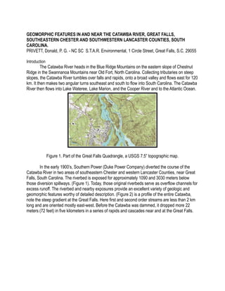
  • 1. GEOMORPHIC FEATURES IN AND NEAR THE CATAWBA RIVER, GREAT FALLS, SOUTHEASTERN CHESTER AND SOUTHWESTERN LANCASTER COUNTIES, SOUTH CAROLINA. PRIVETT, Donald, P. G. - NC SC S.T.A.R. Environmental, 1 Circle Street, Great Falls, S.C. 29055 Introduction The Catawba River heads in the Blue Ridge Mountains on the eastern slope of Chestnut Ridge in the Swannanoa Mountains near Old Fort, North Carolina. Collecting tributaries on steep slopes, the Catawba River tumbles over falls and rapids, onto a broad valley and flows east for 120 km. It then makes two angular turns southeast and south to flow into South Carolina. The Catawba River then flows into Lake Wateree, Lake Marion, and the Cooper River and to the Atlantic Ocean. Figure 1. Part of the Great Falls Quadrangle, a USGS 7.5” topographic map. In the early 1900’s, Southern Power (Duke Power Company) diverted the course of the Catawba River in two areas of southeastern Chester and western Lancaster Counties, near Great Falls, South Carolina. The riverbed is exposed for approximately 1090 and 3030 meters below those diversion spillways. (Figure 1). Today, those original riverbeds serve as overflow channels for excess runoff. The riverbed and nearby exposures provide an excellent variety of geologic and geomorphic features worthy of detailed description. (Figure 2) is a profile of the entire Catawba, note the steep gradient at the Great Falls. Here first and second order streams are less than 2 km long and are oriented mostly east-west. Before the Catawba was dammed, it dropped more 22 meters (72 feet) in five kilometers in a series of rapids and cascades near and at the Great Falls.
  • 2. Figure 2. A profile of the entire Catawba, note the steep gradient at the Great Falls Regional Geologic Overview And Descriptive Geology Of The Great Falls Meta-granite The Great Falls Meta-granite (GFM) is part of the Carolina terrane near the boundary between the Carolina Slate belt and the Charlotte belt, these areas are underlain by metamorphic rocks and are intruded by several types of plutonic rocks included are granite, gabbro, and diabase. The metamorphic rocks consist of gneiss, schist, phyllite, metasedimentary and metavolcanic rocks. Plutonic rocks of Late Proterozic to Cambrian ages are similar to igneous rocks in the Carolina slate belt and intrusive rocks with calc-alkaline affinity in other parts of the Piedmont. The GFM is 543 + 63 m.y.o. (Fullagar, 1971). The Great Falls Meta-granite is an oval shaped discordant intrusion, nearly 10 x10 or 100 – km2. The pluton cuts a complex of biotite gneiss, granitic gneiss, amphibolite, and meta-tonalite. Near Great Falls the pluton is extensively exposed, GFM bedrock is jointed and sometimes sheared, is cut by aplite and pegmatite veins, includes partly assimilated mafic xenoliths, disrupted mafic dikes with flow features, and long (30 - 200 m.) tabular vertical mafic dikes. Large semi- spherical and oval corestones, stacked oval to spherical occasionly mushroom shaped boulders - tors are common. Fabric is equigranular to foliated. The regional foliation found in the metagranite trends N15 to 25 E. The texture of the granite is mostly hypidiomorphic granular with minor porphyritic and aplitic textures. A mylonitic fabric is present along ductile shear zones.
  • 3. Figure 3. Fabric and textural variations of the GFM at the Great Falls.Streaks of darker biotite rich GFM alternating with lighter coarse-grained GFM Figure 4a. Equi-granular textured granite, feldspar is pink, here partly replaced by laumontite.
  • 4. Figure 4b. Equi-granular textured granite, typical color and texture. The meta-granite is fairly homogeneous in mineralogy and texture. It is composed of approximately 35% microcline, 25% plagioclase (oligoclase), 30% quartz, I0% biotite and muscovite. Garnet, biotite, muscovite, pyrite, sphene, laumontite and zircon are accessory and secondary minerals in some thin sections. Unweathered rock is speckled black and light blue-gray and is medium-grained hypidiomorphic granular,(Figure 3) except near the margins where a micro-porphyritic texture predominates and a foliated fabric is present plagioclase is saussuritized, and microcline is sericitized. (Privett, 1984). Epidote and laumontite occur as random patches (1-2 cm), of fine grains, as fracture fillings and replacing some plagioclase and epidote. Metamorphism has altered the mineralogy and texture of the original rock. Quartz displays undulose extinction, plagioclase is saussuritized, and microcline is sericitized. Secondary epidote occurs as random patches (1-2 cm), of fine grains, as fracture fillings and replacing plagioclase. (Figure 4). The pluton may represent the nearly circular basal part of a magma chamber of a deeply eroded volcano, the deep-seated portion of an acidic sub-volcanic complex and was possibly a source of rhyolitic flows in the Carolina slate belt to the east. Some dikes in the granite may have been feeders for mafic flows in the Slate Belt. The Great Falls Meta-granite pluton, is a Cambrian or late Proteroezoic (Pre-Cambrian) biotite metagranite and is well exposed in parts of Chester, Lancaster and Fairfield counties, South Carolina (Privett, 1985, 1997,1998). In saprolite and bedrock exposures, mafic dikes, aplites, shear zones and small narrow pegmatites cut the granite. The best bedrock is exposured in the Catawba River bed, boulders along the riverbanks, cliffs and promontories of two islands, in quarries, and railroad cuts. Overall outcrop distribution is probably due to the relatively rapid downcutting of the Catawba River initiated by lowered base level during Pleistocene sea-Ievel fluctuations. Terrace gravels, the only constructional geomorphic feature are preserved 20 m above the present river flow and show that extensive downcutting has occurred. Along broad divides the meta-granite is deeply weathered, on the uplands saprolite varies in thickness, from 0 to 10 m.? thick. On slopes saprolite, is only 0–1.0 m. thick. First and second order streams in and around Great Falls mostly flow in saprolite.
  • 5. XENOLITHS Blocks and smaller fragments of the surrounding country rock broken off by the upward moving magma ( Figure 4C) are present in the soldified pluton. Most xenolith margins are melted and rounded at the contact by the heat of the granite magma. Figure 4C. Meta-granite showing several large ( 0.8 to 1.2 m.) mafic xenoliths. MAFIC DIKES Meta-granite is cut by two tabular dike fields. One set strikes mostly north. The other set is oriented N 15 E. and range from a few cm to 0.6 m. wide by 30 - 90 m. long. Dikes generally follow north - south striking joints. Mafic dikes are easily spotted, they weather more readily compared to the metagranite.Some dikes are Paleozoic and are metamorphosed. They are composed of plagioclase, hornblende, epidote and chlorite, they have relict subophitic to recrystallized granoblastic and decussate textures (Privett, 1984). Others appear to be unmetamorphosed. Figure 5. Long trails of curved partly assimilated mafic dikes or xenoliths in metagranite.
  • 6. The youngest intrusive rocks are Triassic?/Jurassic olivine bearing diabase dikes which vary in width from a one foot to 200 feet wide and strike northeast to northwest widely variable in width. Long trails of irregular, discontinuous, partly assimilated disrupted curving partly necked and flow orientated biotite rich mafic dikes or mafic xenoliths cut the meta-granite. (Figure 5 ). Within the dike, mafic minerals sometimes show flow banding. Outcrops exposed in the river bed show depressions suggesting that the dikes were mechanically and chemically weaker and have been eroded by bedload, bottom turbulence and solution. In some exposures the margins are depressed while the center project up. Multiple intrusion of mafic dikes and also cut the granite. They have sharp contacts with the meta-granite (Figure 6) In one exposure, a 0.5 m. wide dike striking N. 20 E is off set about 0.5 m by left lateral faulting. (Figure 7a.) Most of the dikes are vertical (Figure 7b). Figure 6. Shows contacts of the GFM with a 5-cm wide mafic dike.
  • 7. Figure 7a. Mafic dike that appears to be off set about, 0.5 m by left lateral faulting. Catawba riverbed. Mafic dikes sometimes display negative relief compared to the meta-granite. Figure 7b. Mafic dike cutting the meta-granite.
  • 8. JOINTING Meta-granite exposed in the riverbed is cut by widely spaced steeply dipping east-west striking joints.(Figure 8). Figure 8. Typical vertical joints exposed in riverbed just below Spillway Dam. Figure 9. Closely-spaced disk shaped joints in riverbed just below the Fishing Creek Spillway Dam Catawba riverbed. In one outcrop, about midway across the overflow spillway below Fishing Creek Dam and for about 10 to 20 meters, closely spaced unusual nearly vertical curved disk-like joints 2 cm. to 8 cm. apart are exposed. (Figure 9). Here, the granite is intensely fractured; these joints separate the meta-granite into curved disk-shaped pieces. Many joints have some minor offset. Major fractures strike N10 E., dip 55 to 80 NW. (Figure 10).
  • 9. Figure 10. South facing view of the entire Catawba riverbed. South-North striking vertical dipping joints and flow rounded boulders. Geomorphic Features Tors Tors are roundered boulders of meta-granite on hilltops and on slopes. Rapids and falls formed when tors and bedrock were exhumed. Downcutting produced rapids and cascades and with increased erosion stripped most saprolite cover exposing meta-granite tors on most slopes. Good exposures are found in and around the Town of Great Falls.Tors are probably the the result of several episodes of weathering, and were probably formed in the Cenozoic when periods Figure 11. Large tor at edge of the river bed. Did it roll down a slope and onto rock in the river? Long bypass diversion.
  • 10. of warm weather produced chemical weathering which alternated with cooler periglacial (freeze- thaw) periods. The Catawba tors are large boulders exposed on hilltops and on steep slopes. (Figure 11). They have a long geologic history starting in the Paleozoic era when the GFM solidified from magma 7-9 km. deep. The Catawba tors were likely formed during Pliocene and Pleistocene sea level fluctuations, when increased erosion and down cutting by the Catawba River removed saprolite along the steeper slopes, exposing widespread spherical boulders, stacked tor clusters and partly exposed tors and bedrock. Exfoliation In vertical exposures, horizontal to sub-horizontal exfoliation jointing is apparent. Joints of this type contribute to the formation of very large thin slabs of meta-granite (Figure 12). In some large exposures, nearly flat exfoliation slabs have been carried by floodwaters. One exfoliation slab, 2 m by 2 m in surface dimension and 2.0 to 2.5 cm thick (Figure 13) was deposited intact on nearby rocks. I photographed that slab in 1990, regrettably the figured slab had been mostly destroyed (vandalized) as of late 1999. Destruction of treasures like these by unknowing or thoughtless persons deprives us all. The figures are presented as documentation of a feature now lost and as a plea to other users of the outdoors to appreciate, share and preserve, rather than to destroy natural exposures.(Figure 14). Figure 12. Very large exfoliation slab shaped by water flow. Catawba riverbed.
  • 11. Figure 13. Large thin exfoliation slab probably moved by floodwaters. Figure 14. Same slab later partly destroyed. Near Great Falls, the river has cut a deep channel through saprolite exposing an extensive boulder or tor field, before cutting into the meta-granite bedrock. Size and the shapes of boulders, boulder domes and pedestal rocks are determined by joint spacing and orientation. Alternating warm weather chemical weathering and cooler periglacial (freeze-thaw) mechanical periods aided erosion on steep slopes. On the uplands, stacked tors fields are concentrated near mid-slope, and along the river at the base of slopes. Many of the round boulders may have rolled into position in the river from steep slopes with movement possibly initiated by earthquakes.
  • 12. Figure 15. Seven-foot boulder perched atop a 25-foot cliff could roll with the slightest vibration. Located on the western Lancaster County side of the Catawba riverbed. Figure 16. Large stacked field of tors with exfoliation fractures on retreating upland surface. West Jefferson Street, The perched tor on the cliff could roll into the riverbed from a little vibration. (Figure 15). Downcutting of the GFM produced rapids and cascades and stripped the saprolite cover on slopes exposing granite tors. The best examples of tors are found in and around the “Town of Great
  • 13. Falls.Large tors and tor clusters - some embedded in saprolite, others at the surface - are widely distributed on the slopes to the river in an area of several square kilometers. Individual boulder range from 2 - 6 m. while tor fields extend up to 80 x 80 meters. In the larger tor fields, there appears to be some stacking. (Figure 16). Figure 17. Large bedrock dome and large rounded tor in the exposed Catawba riverbed, below Fishing Creek spillway dam. Tors are exposed on steep slopes; the topographically higher upper tors appear to have rolled onto the lower ones. Partly formed tors are present on bedrock domes. (Figure 17). Cavitational Weathering Figure 18. Cavitational weathering of meta-granite Cavitational weathering is present in some upland tors (Figure 18). They formed by combination of physical freeze-thaw spalling and chemical decomposition by seeping and standing water. The Great Falls of the Catawba Fluting and Polishing
  • 14. The riverbed of the Great Falls Diversion is exposed below a tall spillway dam for the Dearborn/Great Falls reservoir and exposes the lower part of the “Great Falls of the Catawba”. Near the base of the Great Falls cascade a variety of geologic and geomorphic features are present. Potholes (25 - 40-cm. wide and 30 cm. deep) are present in the exposed rocks. (Figure 21). Surge stones are still present at the bottom of the some potholes. Figure 19. Fluted metagranite (close-up - 3-cm wide driftwood log) note small rounded xenoliths? At left top center. Great Falls riverbed. Potholes Figure 20 a. Fluted metagranite exposed at the base of the Great Falls of the Catawba. View looking south. Great Falls riverbed. Several small circular depressions are initial pothole development. At bottom right (of photographs large pothole with small tree in center.
  • 15. Figure 20 b. Large polished exposure of GFM below the Great Falls of the Catawba, backpack. Figure 20 c. Symmetrical flutes how long would it take for these to form?.
  • 16. Figure 20 d. A mystery? Near the base of the cascade, bedrock is fluted and has been polished (Figure 19) smooth by water flow and fine suspended sediments. Flutes are orientated parallel to river flow. (Figure 20 b and 20 c.) They range in size from 1.0 to 3.0 cm. in depth. Fluting and smooth polish is evidence for turbulent water flow for a very long time. Figure 20d above, what? What caused these features? a.
  • 17. b. Figure 21 A. and B. Large pothole exposed at the base of the Great Falls of the Catawba. Notice the fluted and polished metagranite above the pothole. Great Falls riverbed. Surge stones are present in the bottom of pothole. Figure 22. Meta-granite exposed on the west side of Mountain Island at the Great Falls of the Catawba. Great Falls riverbed. Iron (Fe+++) oxide has been precipitated from water vapor spray on the GFM exposed near the base of the falls, this vapor spray has stained the rock above the falls with red-brown iron oxide which provides additional evidence for the location of the Great Falls of the Catawba. (Figure 22.) Pedestal Rocks
  • 18. Figure 23. Pedestal rock in main river channel Catawba riverbed. Pedestal rocks are present in the exposed river channel, they range from 2 x 3 m. to 1 x 2 m. They result from constant river flow that partially to completely undercut the meta-granite tor near the base. They provide evidence regarding variations of water depths which was never normally higher than 0. 60– 0.90 m. (Figure 23 and Figure 24). Figure 24. Another pedestal rock in main river channel Catawba riverbed. CONCLUSIONS/SYNTHESIS – GEOMORPHIC EVOLUTION This area has undergone several tectonic cycles, with volcanic activity, metamorphism, igneous intrusion and erosion over geologic eons, all of which helped expose the metagranite. An interpreted geologic history spanning 600 million years, from Late Proterozoic to present is summarized here. The Great Falls intrusion forced upward older volcanic rocks. Tectonically, this area is an uplifted subducted boundary margin; the rocks we see today originated or crystallized at depths of 6 - 9 kms. Since cooling, the rock has been involved in three mountain building events
  • 19. each bringing the rock closer to the surface, these events also altered the granite when it was heated and changed by pressure (metamorphosed) during the Taconic, Acadian or Alleghanian orogenies. Rock at the surface today, was probably exposed during the past in the past million years. The last intensive down cutting by the river was between one million to 12,500 years ago. During Pleistocene sea level fluctuations, glacial and interglacial episodes, increased gradients intermittently eroded the Catawba River. Downcutting removed saprolite along steeper slopes exposing widespread single and multiple corestone tors. Tors on the divides are embedded in saprolite. Upper tors collapsed onto the lower ones in the larger tor fields on steep slopes. Along the Catawba River cascades, rapids and falls formed at several locations where tor fields and large near-surface bedrock exposures were exhumed along the Great Falls of the Catawba which dropped about 20 meters, the river itself a total of 38 meters in a distance of 20 kilometers. Drainage draws along upper reaches of some area creeks expose widespread spherical boulders and stacked tor clusters. With increased river grade -- rapids, falls and cascades formed when tors and bedrock were exhumed, most saprolite cover was striped away. Large embedded and stacked oval to spherical occasionally oval shaped tors, and tor clusters were exposed. Large mushroom shaped tors are exposed on the steeper slopes to the riverbed and in the dry riverbed. Meta-granite bedrock is jointed and sheared, is cut by aplites, mafic dikes and pegmatites. Long trails of disrupted and necked flow orientated mafic schlerien or partly assimilated mafic xenoliths are found in some outcrops. A more biotite rich metagranite displays flow-like structures. Vertical exposures of the meta-granite display horizontal exfoliation jointing. Joints of this type contribute to the formation of very large thin slabs of granite. Widely spaced vertical east west-striking joints cut the meta-granite permitting deep weathering and formation tors and tor fields. ACKNOWLEDGEMENTS I thank Mr. Leonard S. Wiener, Geologist, for his insightful and complete review of my manuscript and Mr. Scott Howard of the SC Geological Survey for his valuable help on a field visit and his keen criticisms. I thank Mr.Maurice Blackburn, Carolina Canoe Club for use of his photograph, my Figure 17. Thanks to Phobe Bernat for her skilled editoral review and geological suggustions Jenn Huff, Member Duke Energy Reliscening Team drawing from the Duke Power Repository BIBLIOGRAPHY Duke Power Company Report on the internet, Topographic profile of the Catawba River. Fullagar, P. D., 1971, Age and origin of plutonic intrusions in the Piedmont of the southeastern Appalachians: Geological Society America Bulletin, v. 82, p. 2845-2862. Privett, Donald, 1985, The Great Falls meta-granite, north central S.C.:South Carolina Geology, v. 28, p. 1-5 Privett, Donald 1997, Catawba River Bed Geology, Near Great Falls Southeastern Chester and Lancaster Counties, South Carolina. Abstracts with program: Southeast GSA v. 29, no.3, p.63-64.
  • 20. Privett, Donald, 1998, Tor Fields in the Great Falls Metagranite And their Influence On The Catawba River Sub-Grade, Chester County, South Carolina: Abstracts with program, Southeast G.S.A. v. 30, no.4, p.55. Privett, Donald, 2007, Where is the Great Falls of the Catawba? Geology, Archeology a History: Southeastern GSA 56 Annual Meeting. V. 39. APPENDIX I
  • 21. A. Corp of Engineers, 1879, Survey of the Great Falls of the Catawba, Source Jenn Huff, Member Duke Energy Reliscening Team from the Duke Power Repository. B. Copy of part of the Mills Atlas. 1825.
  • 22. C. Duke (Energy) Power drawing, for area cira 1912, colored and text added.