Fawzia Fawzy Abd El Baky is an Egyptian GIS specialist with over 15 years of experience. She has a bachelor's degree in geography from Cairo University and is proficient in GIS software such as ArcGIS. Her career has included work on geological, land use, utility, and cadastral mapping projects in Egypt and other countries. Currently she is a GIS consultant for Egypt's Ministry of Water Resources and Irrigation and manages a GIS education page on Facebook.
This is the presentation on GPS AIDED GEO AUGMENTED NAVIGATION (GAGAN) developed by India and thus becoming the 4th country after USA, Europe & Japan to have its own SBAS (Satellite Based Augmented Navigation).
This is the presentation of the project we did as a part of our final year project. We have developed a utility management system for a housing company using web GIS. Please feel free to contact in case of any queries.
This chapter discusses how the human operators exercise control over the UAV and its payloads.
There r some key functions av
Piloting the aircraft: making the inputs to the control surfaces and propulsion system required to take off, fly some specified flight path, and land.
Controlling the payloads: turning them on and off, pointing them as needed, and performing any real-time interpretation of their outputs that is required to perform the mission of the UAS.
Commanding the aircraft: carrying out the mission plan, including any changes that must be made in response to events that occur during the mission.
Mission planning: determining the plan for the mission based on the tasking that comes from the “customer” for whom the UAS is flying the mission.
Target Detection, Recognition, and Identification:Imaging sensors are used to detect, recognize, and identify targets.
The successful accomplishment of these tasks depends on the interrelationship of the system resolution, target contrast, atmosphere, and display characteristics
One of the most common missions for a UAV is reconnaissance and/or wide-area surveillance.
These missions require the UAV and its operator to search large areas on the ground, looking for some type of target or activity. An example might be to search a valley looking for signs of an enemy advance.
There are three general types of search:
1. Point
2. Area
3. Route
3D GIS brings enhanced depth into data collection and analysis by incorporating a z-value into mapping. Most commonly, that means including elevation data, but users have many options for adding layers of information.
While 3D models are more difficult to create and maintain than 2D ones, there are myriad 3D GIS applications where this technology is greatly beneficial.
The 3D-GIS in the Cloud main purpose is to evaluate the use-efficiency of both existing and planned spatial space.
Digitizing in GIS is the process of converting geographic data either from a hardcopy or a scanned image into vector data by tracing the features. During the digitzing process, features from the traced map or image are captured as coordinates in either point, line, or polygon format
A geographic information system (GIS) is a system designed to capture, store, manipulate, analyze, manage, and present all types of geographical data. The acronym GIS is sometimes used for geographical information science or geospatial information studies to refer to the academic discipline or career of working with geographic information systems and is a large domain within the broader academic discipline of Geoinformatics. In the simplest terms, GIS is the merging of cartography, statistical analysis, and computer science technology.
Presentation: This presentation gives a brief introduction to tools in ArcGIS and was designed for the Surface Water Quality Monitoring (SWQM) GIS training hosted by Texas Commission on Environmental Quality (TCEQ) staff.
Training: The goal of the SWQM GIS training course is to introduce beginner and intermediate GIS users within the TCEQ surface water monitoring network to the geospatial software, skills, analyses, and data most often used by water resource professionals. The training features presentations from a range of GIS experts from TCEQ, TPWD, and other organizations.
More information on the training: https://www.tceq.texas.gov/waterquality/monitoring/training
Drone Insights 2021, and its Impact on other sectors in IndiaKaushik Biswas
The Booming Drone Industry and its prospect by 2025. What are the sectors in which Drones can be used in India, the regulatory frameworks comparing World Vs India, What are the Top 3 companies we can do business with, who are the other players in the industry?
I have also done a small survey on what Indians think about the drone industry overall, and finally a conclusion on where we are vs the world
ILWIS is an acronym for the Integrated Land and Water Information System.
It is a Geographic Information System (GIS) with Image Processing capabilities. ILWIS has been developed by the International Institute for Aerospace Survey and Earth Sciences (ITC), Enschede, The Netherlands.
1. Fawzia Fawzy Abd El Baky
Tel.: (202) 3910355 - 0127512206
1
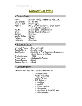
Curriculum Vitae
Personal data:
Name : Fawzya Fawzy Abd El-Baky Abd Allah.
Date of Birth : 6 / 1 / 1983
Place of Birth : Cairo, Egypt.
Address : 17 El-Shiekh Soliman St., Of El- Shiekh
Rihan St., Abdeen, Cairo.
Tel. No. : 0127512206 - 01150468169
Email : fawzia_fawzy@yahoo.com
Gender : Female.
Marital Status : Single.
Religion : Muslim.
Nationality : Egyptian.
Academic Study:
University Name : Cairo University.
Faculty Name : Faculty of Arts.
Qualification : Bachelor of Arts, Geography Department,
Sector Survey and Maps.
Graduation year : 2003.
Project Name : Cartographic Project.
Project Degree : Good.
General Degree : Good.
Computer Skills:
Experience in using computer programs such as:
Microsoft Office
Adobe Photoshop
Adobe Acrobat
GIS Software
o ArcView
o ArcGIS
o Erdas Imagine
o GeoMedia
o AutoCAD & AutoCAD Map
o Microsoft Visio
2. Fawzia Fawzy Abd El Baky
Tel.: (202) 3910355 - 0127512206
2
Training Courses :
GIS Courses:
GIS Fundamentals
ArcGIS I
ArcGIS II
What's New in ArcGIS 9.0
Building Geo Database I
Building Geo Database II
Geodatabase Design Concepts
Data Production And Editing Techniques
QC for GIS Data
QA for GIS Data
Data Production with PLTS
Cartography with ArcGIS
Working with ArcGIS Network Analyst
Working with ArcGIS Spatial Analyst
Working with ArcGIS Utility Network Analyst
Working with 3D Analyst
Geoprocessing Using Model Builder
Intro to Geoprocessing Scripts Using Python
Team Building
Creative Thinking
In Training Center of Quality Standards Company
3. Fawzia Fawzy Abd El Baky
Tel.: (202) 3910355 - 0127512206
3
General Courses:
International Computer Driving Licence (ICDL)
English in LC ACADEMY
Languages:
Language Degree of perfection.
Arabic Native language
English Good
4. Fawzia Fawzy Abd El Baky
Tel.: (202) 3910355 - 0127512206
4
Job History and Achievements:
Scientific Assistant and GIS Specialist and Remote
Sensing field for ( UNDP - UNESCO )
Project for the Capacity Building of the Egyptian Geological__
Survey and Mining Authority (EGSMA)& the National Authority
for Remote Sensing and Space Sciences (NARSS) In
Cooperation with (UNDP) and (UNESCO)from 1 /7/2004 till
30/6/2006.
FIELD OF EXPERIENCE :
Participation in the following GIS and RS Projects:
The Geological Maps of South Western Desert scale
1:250,000 (UNESCO).
The Geological Atlas of South Western Desert scale
1:500,000 (UNESCO).
The Geological Maps of North Western Desert scale
1:250,000 (UNESCO).
The Geological Atlas of North Western Desert scale
1:500,000 (UNESCO).
The Geological Mosaic of South Western Desert scale
1: 1.000.000.
The Geological Mosaic of North Western Desert scale
1.000.000.
Multi Layers of Natural Hazards of South Western
Desert and Sinai.
Geological Lexicon of North Western Desert.
Explanatory Notes to the Geomorphological Maps of
North Western Desert of Egypt.
The Geological Mosaic of Sinai scale 2.000.000.
5. Fawzia Fawzy Abd El Baky
Tel.: (202) 3910355 - 0127512206
5
Geothermal Maps of South Western Desert and Sinai
scale 1:250,000 (UNESCO).
Climatologically Maps of South Western Desert and
Sinai scale 1:250,000 (UNESCO).
Soil Maps of South Western Desert and Sinai scale
1:250,000 (UNESCO).
Gravity Maps of South Western Desert and Sinai scale
1:250,000 (UNESCO).
Scientific Assistant and GIS Specialist for the
Egyptian Geological Survey and Mining Authority
(EGSMA) from 15/1/2006 till 30/6/2006
FIELD OF EXPERIENCE :
Participation in the following GIS Project:
The Geological and Geomorphological layer and
Multi Layers of Natural Hazards of MARSA ALAM
Region.
GIS Specialist As Out Source (2005 - 2006)
FIELD OF EXPERIENCE :
Participation in the following GIS Project:
اﻟﻌﻣراﻧﻰ اﻟﺗﺧطﯾط ھﯾﺋﺔ ﻟﺻﺎﻟﺢ اﻟﻣﺻرﯾﺔ اﻟﻘرى ﺗﺧطﯾط اﻋﺎدة ﻣﺷروع
SMEC International
Create (land use) to Al Quoit government from CAD files to
GIS Data.
Base Map Project for Jeboti
6. Fawzia Fawzy Abd El Baky
Tel.: (202) 3910355 - 0127512206
6
GIS Quality Control Specialist for (Quality
Standards Company) (ESRI Northeast
Africa)
from 1/7/2006 till 30/11/2014.
FIELD OF EXPERIENCE :
Participation in the following GIS Project:
Base Map Projects :
The Project of (Census 2006) for The Central
Agency for Public Mobilization and Statistics
(CAPMAS).
Role: (Editing – Quality Control – Data finalize)
The Project of (Cairo) Scale 2500 for the
Egyptian Electricity Holding Company
(EEHC).
Role: (Project Coordinator)
Al FAO Project Land Use Scale 5000
Role: (Editing – Quality Control – Data finalize)
Etsalat Masr enterprise GIS System
(EME - GS)
Role: (Editing – Quality Control – Data finalize)
Chamber of Commerce (COC)
7. Fawzia Fawzy Abd El Baky
Tel.: (202) 3910355 - 0127512206
7
Role: (Editing – Quality Control – Data finalize)
Real Estate Tax Authority (RETA)
Role: (Editing – Quality Control – Data finalize)
(MOT) Project Land Use for Ministry of
Tourism
Role: (Editing – Quality Control – Data finalize _
Working with Network Analyst for Roads)
Tripoly Project in Libya.
Role: (Editing – Quality Control – Data finalize)
(CSO) Project Land Use for Central statistics
office in EL-KOUIT
Role: (Editing – Quality Control – Data finalize)
(MSAD) Project Land Use for Ministry of State
for Administrative Development.
Role: (Working with Network Analyst for Roads)
Utilities Projects :
Dammam Water & Sewage Networks Data
Conversion for Kingdom of Saudia - Ministry
of Water and Electricity
Role: (Rectification – Editing – Quality Control
– Data finalize – Data Adjustment –
Data Transformation from CAD to GIS)
Saudi Electricity Data Conversion for Saudi
Electricity Company (SEC), Riyadh, Kingdom
of Saudi Arabia
Role: (Rectification – Editing – Quality Control –
Data finalize)
8. Fawzia Fawzy Abd El Baky
Tel.: (202) 3910355 - 0127512206
8
Cadastral Map Projects :
The Project of Cadastral Map of Egypt.
Role: (Editing – Quality Control – Data finalize)
Geological Projects :
(SGS) The Project of Geological Survey of
Kingdom of Saudi Arabia
Role: (Project Coordinator)
CAD Conversion Projects :
(AL DAR) Enterprise GIS – Phase1 for
(UNITED ARAB OF EMARATES (UAE))
Converting AL DAR Master Plan for their
implemented Projects.
Role: (Editing – Quality Control – Data finalize - Data
Transformation from
CAD to GIS)
Raster Analysis Projects :
(Airports of Libya)
EsriNeA provided the following services over
wide 3 airport of Libya:
• Stereo images acquisition.
•Stereo images radiometric correction and
enhancement.
•Applying Geometric Correction using the
collected GCPs and DEM.
•Three 3D vector maps
9. Fawzia Fawzy Abd El Baky
Tel.: (202) 3910355 - 0127512206
9
Airport serviced cities features included Major
emergency services landmarks (Police Stations,
Fire Stations, Hospitals, Ambulance Points)
covering the major cities surrounding the
Airports, in addition to Major Roads.
Sample of Responsibilities:
Study the scope of the projects and prepare the project’s
database
Perform conversion tasks and loading for the data from
older datasets
Conversion cad layers into other GIS formats
Vector analysis using geo processing tools in arc toolbox
Making session to employees in order to understand
project goals and scheme.
Conduct seminars to project members and Quality
Control member to discuss repetitive error and how to
overcome and avoid these errors.
Helping the project manager to finalize the project
Making quality control over the data (geometry –
attributed data) according to ISO 19113 and ISO 19114
standards
Generating Quality Control Reports
Working with geometric network
Working with network analyst for roads
Prepare project plans
Prepare project QA plans
10. Fawzia Fawzy Abd El Baky
Tel.: (202) 3910355 - 0127512206
10
GIS Instructor at Arab Nubia Group for Mining in
Training Department from 1/9/2014 to 15/1/2015
Teach Courses such as:
ArcGIS I
ArcGIS II
ArcGIS III
Building Geodatabase
Network Analyst
Cartography
Manager of GIS Department for Choosing Future for IT
From 1/12/2014 till 1/5/2015.
Teach GIS Courses
Preparing Data for GIS Department in Website of
Company.
Preparing financial and technical offers for the GIS
projects
11. Fawzia Fawzy Abd El Baky
Tel.: (202) 3910355 - 0127512206
11
GIS Consultant and Specialist As Out Source for
Ministry of Water Resources and Irrigation
From 1/6/2015 till now.
FIELD OF EXPERIENCE :
Participation in the following GIS Project:
Master Plan of Hydraulic Structure in Egypt (MPHS)
)ﺑﻣﺻر اﻟﮭﯾدروﻟﯾﻛﯾﮫ اﻟﻣﻧﺷﺄت وﺗﺟدﯾد ﻹﺣﻼل اﻹﺳﺗراﺗﯾﺟﯾﺔ اﻟﺧطﮫ(
Admin of (GIS Academy) Page on Facebook
https://www.facebook.com/gis.a.eg
My Channel on YouTube (Fawzia Fawzy)
https://www.youtube.com/channel/UCvbpSkCWZ4-
QnK0YqjpxfRg
(Containing instructional videos in the field of GIS)