MANUFACTURING PROCESS-II UNIT-1 THEORY OF METAL CUTTING
C -users-mmusa-desktop-exams-final exam (1)
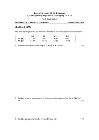
1. Birzeit University Birzeit University
Civil Engineering Department – Surveying I (CE330(
Final Examination
Instructors: K. Abaza & M. Abedmousa Summer 2009/2010
Problem 1 ( 15%(
The table below provides the measured departures and latitudes for a closed traverse.
AB BC CD DE
ΔE (m) -43.62 70.85 50.87 - 24.15
ΔN (m) -61.35 -34.72 48.22 73.35
1. Find the measured traverse angles at points B, C, and D. (8%)
2. Find the traverse angular error if the known azimuth of the last line is 341° 46'
55''. (3%)
3. Find the corrected azimuths of lines BC and CD. (4%)
2. Problem 2 (15%)
The following table provides the measured distances and corrected azimuths for a
closed-loop traverse. Knowing that the correct coordinates of point A are E=1200.57
and N=1350.23m.
1. Calculate the linear misclosure error and check it against the third order (class II)
accuracy level requirements. (8%)
2. Calculate the corrected coordinates of point D. (4%)
Line Distance (m) Corrected azimuth
AB 210.67 20° 31' 30''
BC 343.67 357° 16' 00''
CD 126.00 120° 04' 00''
DE 294.33 188° 28' 30''
EA 222.00 213° 31' 00''
3. 3. Assuming the misclosure errors were determined to be ΔE=8.66m and ΔN=-
5.00m. If this was because of a blunder error in the distance measurement of one
traverse line, identify that line. (3%)
Problem 3 (20%)
The data provided in the table below were observed using a Theodolite (HI=1.60m)
stationed at point 6 (E=198.35, N=300.16m) and knowing that the coordinates of
point 1 are (E= 350.25, N= 240.16, Z= 700.16m).
Horizontal circle
reading (CW)
Stadia reading Zenith angle
Station Point R1 R2 R3
6 1 0° 0' 0'' 3.5 94° 15' 0''
2 65° 45' 15'' 1.00 2.06 3.11 88° 15' 0''
3 138° 05' 25'' 2.00 2.58 3.16 92° 30' 0''
4 168° 12' 34'' 0.98 1.07 2.03 72° 13' 0''
5 225° 37' 20'' 2.13 3.20 4.26 103° 10' 0''
1. Calculate the coordinates (E, N) of points 2-5. (10%)
2. Calculate the elevations of points 2-5. (7%)
4. 3. What is the mean slope for the line connecting points 3 and 5? (3%)
Problem 4 (10%(
The level was used in a three-wire leveling circuit with results as provided in the table
below. The level height was 1.650m when stationed at point A whose elevation is
127.925m.
Station (i) Point (j) Azimuth R1 R2 R3 Dij hj
A B 30o
2.725 2.112 1.628
C 60o
3.982 3.327 2.752
D 90o
3.500 2.651 1.590
a) Fill in the values for the distance (Dij) and elevation (hj). (6%)
b) Approximately trace the contour line with 127.5 m elevation. (4%)
Problem 5 (15%)
Given below the measurements obtained using a Total Station. All distance
measurements are in meters.
Station Point Azimuth VD SD R.H. I.H.
A B 347o
20' 16.28 2112.74 1.75 1.60
C 75o
45' -31.15 4171.90
D 133o
15' 17.62 1106.82
a) Find the elevation of point C giving the elevation of point B to be 572.35m. (4%)
5. b) Find the slope distance of line BC. (6%)
c) Find the phase differences used in measuring the slope distances assuming the
modulated frequency is 1.4989625MHz and speed of light is 299,792.5km/s. (5%)
Problem 6 (15%)
Given a six-sided closed-loop traverse with departures and latitudes as given below.
The distance of line AF is measured to be 85.37m and angle BAF (CW) is 17 o
35'.
Line Departure Latitude Point E N
AB -112.87 -75.82 A 500.00 500.00 m
BC - 89.64 -22.16 B
CD -178.11 105.08 C
DE 234.28 45.63 D
E
F
Determine the area of the closed traverse using the coordinate method.
6. Problem 7 (10%(
The ground profile for a proposed route can be represented by the following
mathematical model wherein h(x) is the ground elevation in meters:
140x100x12.08.116
100x40)40x(
120
0.24
-0.12x100
40x0x12.0100
)x(h 2
≤≤−
≤≤−+
≤≤+
=
The final profile has a uniform slope and it intersects the ground profile at stations (x)
20 and 100m. Determine the net volume of excavation (m3
) assuming the route has a
constant width of 15 meters and the compaction factors for cut and fill are 1.18 and
1.12, respectively.
Station (x( 0 20 40 60 80 100 120 140
Ground
level
Final level
Cut depth
Fill depth
7. Problem 7 (10%(
The ground profile for a proposed route can be represented by the following
mathematical model wherein h(x) is the ground elevation in meters:
140x100x12.08.116
100x40)40x(
120
0.24
-0.12x100
40x0x12.0100
)x(h 2
≤≤−
≤≤−+
≤≤+
=
The final profile has a uniform slope and it intersects the ground profile at stations (x)
20 and 100m. Determine the net volume of excavation (m3
) assuming the route has a
constant width of 15 meters and the compaction factors for cut and fill are 1.18 and
1.12, respectively.
Station (x( 0 20 40 60 80 100 120 140
Ground
level
Final level
Cut depth
Fill depth