IJERA (International journal of Engineering Research and Applications) is International online, ... peer reviewed journal. For more detail or submit your article, please visit www.ijera.com
What is MRTS?
History
Role of Civil Engineers
Why MRTS?
Characteristics of MRTS
Network Design Parameters
Types of MRTS Networks
Types of MRTS
Bus Rapid Transit system
Case Study -1 : Ahmedabad BRTS
Metro Rail Transit System
Case Study-2 : Delhi Metro
Mono Rail Transit System
Light Rail Transport System
Impact
Mass rapid transit, also referred to as public transit, is a passenger transportation service, usually local in scope, that is available to any person who pays a prescribed fare.
It usually operates on specific fixed tracks or with separated and exclusive use of potential common track, according to established schedules along designated routes or lines with specific stops.
It is designed to move large numbers of people at one time.
Traffic demand management aims to reduce single-occupancy vehicle travel and redistribute travel demand. Managing traffic demand at junctions is important to reduce accidents, pollution, wasted time and money, and improve public transportation options. Several methods can be used for traffic demand management at junctions, including traffic surveys, educating the public, enforcing traffic laws, improving junction infrastructure with signs, flyovers, traffic lights, and pedestrian crossings, implementing bicycle infrastructure, congestion pricing, active traffic management, and integrated demand management. Case studies demonstrate how these strategies can be applied using existing traffic control systems.
At present, there are many problems being faced by road users in urban area with limitation of land space and traffic congestion, pedestrian are one of the most vulnerable entities of the transportation system It is observed that there is an increase in number of conflicts between pedestrian and the vehicles in the city. In order to mitigate the conflicts between vehicular traffic and pedestrian traffic an attempt is made to provide a Skywalk. The present study involves the Opinion survey of pedestrians, Mid-block traffic count, pedestrian count were carried out for Ashoka road on weekdays and weekends. From the opinion survey, traffic count and pedestrian counts we can conclude that there is a need to construct Skywalk to reduce the pedestrian accidents rates on Ashoka road.
International Journal of Engineering Research and Applications (IJERA) is an open access online peer reviewed international journal that publishes research and review articles in the fields of Computer Science, Neural Networks, Electrical Engineering, Software Engineering, Information Technology, Mechanical Engineering, Chemical Engineering, Plastic Engineering, Food Technology, Textile Engineering, Nano Technology & science, Power Electronics, Electronics & Communication Engineering, Computational mathematics, Image processing, Civil Engineering, Structural Engineering, Environmental Engineering, VLSI Testing & Low Power VLSI Design etc.
Services Model of Microlet Public Transport Based on Characteristics Movement...AM Publications
Mode of transport in the form of urban transportation has a very urgent role in supporting the growth and the development of a city.Microlet is the only public transportation owned by the city of Palu in performing services for users,this public transportation is increasingly unpopular and users tend to be abandoned because of the easeness to get it is very difficult in a sense; where waiting place is not clear, there is no certainty of a long waiting, the negotiations of travel destination and the time required for travelling can not be predicted. The research objective is to create a model that is suitable to be applied based on the people movement characteristics, with the hope of such urban transportation is still able to survive and operate as stackholdersdemands (user, operator / driver and government) and at the end people tend to choose public transportation as an option main mode of transportation in supporting their daily activities. The method of analysis used in modelling the transport trajectory is superimpose method with consideration of; land use patterns, the movement pattern of passengers urban transportation, population density, the service area andthe road networkcharacteristics.Based on the analysis of the division of three zones studied region, then the application of fixed rute is still can be carried out in zone 2 as a downtown area that includes 4 districts namely; West Palusubdistrict, Tatanga, South Palu and East Palu, while the two other zones, namely zone 1 and zone 3 as connector to the city center, city transportation routes can be applied in accordance with the national road that crosses the area of the zone.
Landscape design for multimodal transport corridorsGeeva Chandana
This document outlines the structure and process of a dissertation on landscape design for multimodal transport corridors in Chennai, India. It begins with an introduction to the problem and outlines the objectives and significance of the study. It then describes the research process, including literature reviews, case studies of projects in India and abroad, and data collection through secondary research and primary methods like questionnaires and site visits. Case studies are presented on transport corridors in Chennai like the OMR corridor to analyze the existing landscape and potential for improvement. The goal is to understand how landscape design can enhance multimodal transit systems and the imageability of the city.
This document discusses various topics related to transportation planning. It includes sections on traffic flow characteristics, accident studies, traffic volume studies, speed studies, frequently asked questions, functions, methodology, origin-destination studies, and parking studies. The methodology section outlines the process of transportation planning which includes inventories, trip generation, trip distribution, modal split, traffic assignment, and plan preparation and evaluation. Other topics covered in detail include trip generation and distribution models, origin-destination studies methods, causes of accidents, factors affecting traffic capacity, and types of speed studies.
IJRET : International Journal of Research in Engineering and Technology is an international peer reviewed, online journal published by eSAT Publishing House for the enhancement of research in various disciplines of Engineering and Technology. The aim and scope of the journal is to provide an academic medium and an important reference for the advancement and dissemination of research results that support high-level learning, teaching and research in the fields of Engineering and Technology. We bring together Scientists, Academician, Field Engineers, Scholars and Students of related fields of Engineering and Technology.
Performance evaluation of santasi roundabout, kumasi ghana using micro simula...eSAT Journals
Abstract Roundabouts are an increasingly popular alternative to traffic signals for intersection control in the United States. Roundabouts have a number of advantages over traffic signals depending on the conditions. They reduce the severity of crashes since head-on and right-angle conflicts are nearly eliminated. They reduce through traffic speeds to provide a “calmer” roadway environment. They may consume less land area since turn pocket lanes are not needed and also have lower energy and maintenance costs. This study evaluated performance of Santasi roundabout in Kumasi, Ghana using micro simulation model. Traffic and geometric data were collected on the field. The analysis revealed that Santasi roundabout was operating at a level of service F, which represented worst conditions. Signalized intersection with 4 approach lanes was proposed to control all the movements. Exclusive pedestrian phases were proposed to protect pedestrians. Index Terms: Performance evaluation, Santasi roundabout, Capacity analysis, Transportation network performance
IRJET- A Study on Life Cycle Cost Analysis for RoadsIRJET Journal
This document presents a study on life cycle cost analysis (LCCA) for roads. It discusses LCCA methodology, which considers construction as well as long-term maintenance and rehabilitation costs when evaluating pavement alternatives. The document analyzes the LCCA of a 26km section of the Ghoti-Sinnar Highway in India using the net present value method over a 10-year period. It calculates the construction cost, annual operation and maintenance costs assuming a 10% increase each year, and salvage value to determine the total life cycle cost. The analysis aims to optimize long-term expenses and select the most cost-effective pavement option.
Introduction of basic transportation engineeringGhan Shyam
This document discusses road alignment and classification. It defines road alignment as the position of the center line of the highway on the ground. There are two types of alignment: horizontal and vertical. It also lists factors that affect road alignment such as availability of construction materials, obligatory points, grades, crossings, geology, drainage, traffic, land acquisition, economics, and other miscellaneous factors. The document also discusses engineering surveys used in locating highway alignment and classifications of roads based on use, carriageway, pavement surface, location, traffic, and function.
Existing Facilities And Deficiencies In A Busy Intersection At Dhaka Based On...IJERA Editor
Roundabouts have become increasingly popular in recent years as an innovative operational and safety solution at both low volume and high volume intersections. This paper contains capacity analysis of existing roads at a busy intersection in Dhaka named Polashi intersection, compare capacity and volume, AADT, velocity study, road user behavior, pedestrian flow analysis for proposed roundabout. Evaluations are made on a rational basis using qualitative analysis wherever possible and accepting that some matters determine by the exercise of judgments. Roundabouts have a number of advantages over traffic signals depending on the conditions. They reduce the severity of crashes since head-on and right-angle conflicts are nearly eliminated. They may consume less land area since turn pocket lanes are not needed. They have lower energy and maintenance costs
Capacity and performance analysis of suame roundabout, kumasi ghanaeSAT Journals
Roundabouts are an increasingly popular alternative to traffic signals for intersection control in the United States. Roundabouts have
a number of advantages over traffic signals depending on the conditions. They reduce the severity of crashes since head-on and rightangle
conflicts are nearly eliminated. They reduce through traffic speeds to provide a “calmer” roadway environment. They may
consume less land area since turn pocket lanes are not needed and also have lower energy and maintenance costs.
This study analyzed capacity and performance of Suame roundabout in Kumasi, Ghana. Traffic and geometric data were collected on
the field. The analysis revealed that Suame roundabout was operating at a level of service F, which represented worst conditions.
Signalized intersection with 5 approach lanes was proposed to control all the movements. Exclusive pedestrian phases were
proposed to protect pedestrians.
Index Terms: Performance analysis, Suame roundabout, Capacity analysis, Transportation network pe
IJRET : International Journal of Research in Engineering and Technology is an international peer reviewed, online journal published by eSAT Publishing House for the enhancement of research in various disciplines of Engineering and Technology. The aim and scope of the journal is to provide an academic medium and an important reference for the advancement and dissemination of research results that support high-level learning, teaching and research in the fields of Engineering and Technology. We bring together Scientists, Academician, Field Engineers, Scholars and Students of related fields of Engineering and Technology.
The spectacular growth of the automobile as one of the most convenient modes of travel has brought in its wake frustrating problems of parking, accidents, delay, congestion, etc. It is no longer sufficient to build roads of adequate structural strength to cater to the needs of vehicles, but it is equally important that the safe, efficient and comfortable movement of traffic and other road user is ensured on these roads. Highway intersections are nodes of road networks and accident - prone locations. They are the places where vehicles coming from different approaches and moving towards different directions interact and conflict with each other. Due to the conflicts from all users, more traffic crashes could happen at unsignalized intersection as compared with roadway segments. This study is fully based on the existing conditions of unsignalized intersection, including geometric design, sight distance, traffic control devices etc. The problems of parking, accidents and delay are also prevailing in the area under our study i.e. intersection at 26th mile. The intersection is an unsignalized one and therefore, the chances of accidents during the peak hours are very high. Since, it is a meeting point of a national highway and a state highway, the variation in the design speed of both roads also interrupts the traffic flow. Our study on the intersection at 26th mile mainly aims at improving the geometrical as well as the safety features of the intersection like accident control by signal installation, incorporation of proper sight distances, uninterrupted traffic flow without causing crashes, delay, etc.
IRJET- Mobility Planning for an Indian Pilgrimage City- A Case of Omkares...IRJET Journal
This document discusses developing a mobility plan for Omkareshwar City in India to address transportation issues during pilgrimage periods when over 1 million pilgrims visit. It analyzes the city's existing transport network, which is inadequate. It conducted a travel behavior survey of 269 pilgrims on Mahashivratri festival day. It proposes developing pedestrian routes, expanding transportation infrastructure on main roads, and adding parking facilities. It also recommends separating vehicular and pedestrian movements at junctions to avoid conflicts, and expanding the narrow parikrama path used by pilgrims. The plan aims to provide a safe, convenient, and pollution-free transportation system to facilitate pilgrims during peak periods.
This document discusses transportation engineering. It describes transportation engineering as involving planning, design, operation, and facilities management using scientific principles to develop transportation that is safe, efficient, rapid, comfortable, economical and eco-friendly. The four main modes of transportation discussed are road, water, air and railway. Transportation engineering involves urban planning, design, construction, maintenance and management of facilities. Sections on industry, society, economics and the environment are also developed. The document goes on to classify transportation based on energy source (human, animal, fuel) and surface (land, water, air) and provides examples. It discusses the history and developments of different modes of transportation like railways, water, and air transportation. It concludes with discussions
This is really a good topic for seminar.
in this some information may be old for you by the time you receive this topic but then too i have tried to put recent informations bout this topic.since monorail technology is developing so fast .this may be called as one of the burning topics in civil engineering
The document summarizes a study on rehabilitating an 8 km section of the Altaji-Baghdad highway in Iraq. Laboratory and field testing was conducted to determine the existing pavement conditions and traffic volumes. Various types of failures like rutting, cracking, and potholes were found. An equivalent single axle load was calculated based on traffic data and used to determine the required overlay thickness according to the Asphalt Institute Manual. The recommended rehabilitation plan involves scraping and cleaning rutted areas, constructing 50mm and 55mm asphalt layers, and a 10-15cm subbase layer to increase the highway's service life and capacity.
A documentation of our study, critical appraisal and analysis of the area around the Rourkela Railway Station and the attempt to transform the zone into a Multi-Modal Hub keeping in purview the close proximity of the Bus Station and Intermediate Public Transport service.
This document provides an overview of key concepts in transportation engineering, including elements of traffic engineering and traffic control. It discusses factors that affect traffic such as road users, vehicles, and the environment. It also summarizes major sections of traffic engineering like traffic characteristics, studies, operation, planning, and management. Specific traffic studies covered include volume, speed, delay, origin-destination, flow, capacity, and parking surveys. Traffic control devices like signs, signals, markings, and delineators are also introduced.
The document discusses different types of monorails including straddled beam, suspended monorail, and magnetic levitation monorails. It describes the planned Calicut monorail in Kozhikode, India, which would use a straddled beam type due to heavy traffic and narrow roads. The Calicut monorail would run from Kozhikode to Medical College and have 15 stations. It also discusses monorail infrastructure requirements and operations, as well as the mechanical components and examples of monorails in other cities. In conclusion, monorails can help develop transportation and industries while minimizing environmental impacts compared to other transit systems, though the initial costs are higher.
Lec 01 Introduction of Transportation Engineering (Transportation Engineering...Hossam Shafiq I
This document discusses transportation systems and their various components. It defines transportation engineering and notes that transportation systems consist of fixed facilities like roads and railroads, vehicles that use these facilities, and control systems to guide traffic. It categorizes transportation systems into four main modes - land, water, air, and pipelines. Each mode has distinct characteristics in terms of speed, accessibility, costs, capacities, and environmental impacts. Urban transportation focuses on passenger transport using modes like buses, light rail, and rapid transit rail. The document provides details on various urban transit options and their characteristics.
This document provides an overview of transportation engineering, including the objectives of the course and various modes of transportation. It describes the main modes as road, rail, maritime, air, and pipelines. It also defines a transportation system as consisting of fixed facilities, flow entities, and a control system. Transportation planning is discussed as a process involving survey, analysis, forecasting, evaluation, adoption, implementation and ongoing studies to develop an efficient system.
This document analyzes and summarizes issues with the multimodal transit hub at Anand Vihar, New Delhi. It finds that the bus terminal has congestion due to a shared entry/exit, lack of separation between inter and intra terminals, and insufficient space. The metro station also has congestion and lacks proper connectivity to the bus terminal and railway station. The railway station has limited space for waiting and ticketing. Overall, the site suffers from a single entry/exit point that causes road congestion, long walking distances between transit modes, and conflict points where pedestrian and vehicle traffic mix. Proposed solutions include increasing the length of the foot overbridge and road width to address these connectivity and congestion issues.
This document discusses monorail technology and provides details about its history, types, and construction. It begins with an introduction to monorails, including how they work using magnetic levitation. It then discusses the history of monorails dating back to 1820 and provides examples of modern monorail systems. The document outlines the two main types of monorails - straddle beam and suspended. It also describes the simple construction process of monorails and factors that influence their constructability. Finally, it provides examples of famous monorail systems around the world and those currently being developed in India.
The document discusses the Mumbai Monorail system. It provides details on the history, construction, ownership, operations, merits and demerits of the monorail. The Mumbai Monorail is owned and operated by the Mumbai Metropolitan Region Development Authority. It was built to provide feeder service to Mumbai's suburban rail network and runs along an 8.9 km elevated track between Chembur and Wadala, with plans to expand further. Key benefits include lower noise and pollution compared to buses, but it relies on electricity and a full shutdown is required to replace any section of track.
IJERA (International journal of Engineering Research and Applications) is International online, ... peer reviewed journal. For more detail or submit your article, please visit www.ijera.com
This document examines the reactivity of cement combinations containing Portland cement, fly ash, silica fume, and metakaolin by investigating their calcium hydroxide (Ca(OH)2) consumption. Various binary and ternary cement pastes were tested at ages of 28, 90, and 180 days. The results show that silica fume consumed the most Ca(OH)2, followed by metakaolin, then fly ash. Ca(OH)2 consumption increased with age and addition content up to certain limits. Combinations with finer pozzolans like silica fume and metakaolin showed higher reactivity, especially at early ages.
IJERA (International journal of Engineering Research and Applications) is International online, ... peer reviewed journal. For more detail or submit your article, please visit www.ijera.com
This document discusses the IEEE 802.3ba standard for Ethernet speeds of 40 Gbps and 100 Gbps. It describes the objectives of the standard to support speeds faster than 10 Gbps. The standard defines physical layer specifications for 40 Gbps and 100 Gbps transfer rates, including defining new Ethernet physical layer devices, sublayers, and interfaces to support these higher speeds.
The document describes a study that fabricated Al-10% Al2O3-10% ZrO2 nanocomposite powders using high-energy ball milling. The powders were milled for various time periods up to 45 hours. Characterization of the milled powders found that milling resulted in a uniform distribution of the Al2O3 and ZrO2 reinforcements in the Al matrix. X-ray diffraction analysis showed increased peak broadening with longer milling times, indicating reduced crystallite size and increased lattice strain. Crystallite size measurements found sizes decreased to around 25 nm after 45 hours of milling. Scanning electron microscopy images confirmed the uniform distribution of reinforcements and decreasing particle size
IJERA (International journal of Engineering Research and Applications) is International online, ... peer reviewed journal. For more detail or submit your article, please visit www.ijera.com
International Journal of Engineering Research and Applications (IJERA) is an open access online peer reviewed international journal that publishes research and review articles in the fields of Computer Science, Neural Networks, Electrical Engineering, Software Engineering, Information Technology, Mechanical Engineering, Chemical Engineering, Plastic Engineering, Food Technology, Textile Engineering, Nano Technology & science, Power Electronics, Electronics & Communication Engineering, Computational mathematics, Image processing, Civil Engineering, Structural Engineering, Environmental Engineering, VLSI Testing & Low Power VLSI Design etc.
La Web 2.0 permite a los usuarios participar en la creación y distribución de contenido en la web. Los sitios Web 2.0 obtienen su valor de las acciones y participación de los usuarios, quienes dejan de ser meros lectores para convertirse en autores. La Web 2.0 fomenta el aprovechamiento de la inteligencia colectiva a través de la contribución de los usuarios.
Este documento presenta 20 opciones de menús para un restaurante. Cada opción incluye entradas, un plato principal de pescado o carne para elegir, bebidas y postre. También se ofrecen menús infantiles y opciones de bebidas adicionales. El restaurante se compromete a adaptar los menús para atender necesidades alimenticias especiales y garantiza el éxito de las celebraciones en sus instalaciones.
Competencias comunicativas para el nuevo sigloduvan34
El documento define las competencias docentes como el conjunto de recursos, conocimientos, habilidades y actitudes que necesitan los profesores para resolver situaciones en su trabajo y vida diaria. Explica que las competencias docentes implican aplicar lo aprendido de manera teórica de forma práctica. También enumera habilidades que el alumno quiere desarrollar como docente, como planificar lecciones, usar tecnología en la enseñanza, y interactuar de forma respetuosa con estudiantes.
El documento describe los procedimientos y formalidades que deben seguirse durante un juicio penal en Venezuela de acuerdo al Código Orgánico Procesal Penal. Explica que al comenzar el juicio, el juez verificará la presencia de las partes y declarará abierto el debate, advirtiendo la importancia del acto. Durante el juicio, el fiscal y querellante presentarán sus acusaciones y la defensa presentará su caso. Al final, el juez leerá la sentencia ante las partes presentes.
Este documento fornece uma série de exercícios para ensinar habilidades básicas de futebol como passe, condução de bola, remate, drible, cabeceamento, desarme, interceptação, marcação e desmarcação. Os exercícios são apresentados com esquemas ilustrativos e objetivos de aprendizagem para o professor escolher de acordo com o nível dos alunos.
John Dewey (1859-1952) fue un filósofo, pedagogo y psicólogo estadounidense conocido por desarrollar una filosofía que abogaba por la unidad entre la teoría y la práctica. Su pensamiento se basaba en la convicción de que la democracia es libertad y dedicó su vida a fundamentar esta idea filosóficamente y promoverla en la práctica. Sus obras completas fueron publicadas póstumamente en treinta y siete volúmenes.
La retención en la fuente es un mecanismo para recaudar impuestos de manera anticipada sobre pagos realizados a personas. Originalmente surgió para recaudar el impuesto sobre la renta de inversionistas extranjeros. Tiene como objetivos acelerar y asegurar el recaudo de impuestos para el estado y prevenir la evasión. Algunos de los impuestos sujetos a retención son renta, IVA, timbre e impuestos a remesas y movimientos financieros. La retención puede ser descontada de los impuestos ade
El documento presenta los criterios para determinar si la información de una página web es confiable o no. Los criterios incluyen la veracidad del autor, facilidad de acceso a la información, distribución de la información, actualización, ejemplos, respaldo de una organización, gratuidad, edición, enlaces seleccionados y seguridad de la página.
Nuestros alumnos de infantil visitan a los ancianos de la residencia santa l...sanjose1
Los alumnos de infantil visitaron dos residencias de ancianos donde cantaron villancicos y actuaron para alegrar a los residentes, y también recibieron la visita de los ancianos en su colegio, intercambiando regalos y pasando un día estupendo compartiendo la Navidad.
Modelos de negocio en el comercio electronicoalejandra6zu
Este documento describe cuatro modelos de negocio en el comercio electrónico: B2C (de empresa a consumidor), B2B (de empresa a empresa), C2B (de consumidor a empresa) y M2B (de móvil a empresa). B2C se refiere a las ventas directas de empresas a consumidores a través de internet. B2B implica la venta entre empresas. C2B permite a los consumidores ofrecer productos y servicios a las empresas. Y M2B aprovecha dispositivos móviles para conectar a usuarios con sit
MODELLING OF PEDESTRIAN GAP ACCEPTANCE BEHAVIOUR AT UNCONTROLLED INTERSECTIONSIRJET Journal
This document summarizes a study that aimed to model safe gap acceptance behavior for pedestrians crossing at uncontrolled intersections. The researchers collected data on pedestrian and traffic characteristics like speed, volume, and gap lengths at four intersections through video recordings. They then used multiple linear regression to develop a model for the length of gaps accepted by pedestrians based on variables like traffic volume, pedestrian speed, number of rejected gaps, and presence of traffic controls. The model can help analyze pedestrian safety and risks at uncontrolled crossings.
Pedestrian priority in urban area and usefulness towards communityeSAT Journals
Abstract Transportation network has become nerve of any city, the paradox here is that though meant for human travel, these roads hardly provide any quality space for those who are without vehicles (well known as pedestrian). Due to the ambiguous position of non-motorized travel in an urban transportation system, the transportation conditions for non-motorized travel are getting worse in cities, which illustrate the urgent need for the improvement for same. There is a requirement of combining traffic issues with pedestrian in a comprehensive manner and will make it an important part of road design. Preservation of nature, opportunities for cultural interface, a resource conserving environment with workable public transit and more occasions for walking should be prime objectives of urban planners. For urban development, pedestrian system should be well designed, safe and convenient. The Pedestrian Zone is the primary component of every street in a city. It is not only a zone to ensure smooth, comfortable, conflict free movement of pedestrians and public transport users, but also an area which shapes social interactions, safety and quality of life of people in a city. Pedestrian priority thus becomes a major and a very important phenomenon for urban development which in a way helps quality of life in an urban area. With the increase in population and keeping in view the world pedestrian scenario, this paper will bring some notices to facilities required, mode of travels to be looked upon and other such major issues are discussed.
IJRET : International Journal of Research in Engineering and Technology is an international peer reviewed, online journal published by eSAT Publishing House for the enhancement of research in various disciplines of Engineering and Technology. The aim and scope of the journal is to provide an academic medium and an important reference for the advancement and dissemination of research results that support high-level learning, teaching and research in the fields of Engineering and Technology. We bring together Scientists, Academician, Field Engineers, Scholars and Students of related fields of Engineering and Technology
Most major cities are facing traffic problems due to delays and overcrowding caused by increased populations. This document discusses the problems of traffic delays and overcrowding in urban areas and potential solutions. It analyzes causes such as mixed traffic conditions, irregular parking, and temporary events. Solutions proposed include separate traffic lanes for vehicle types, improved parking, expanded roads, intelligent transportation systems, and public transportation infrastructure like flyovers and metro rails. The author concludes that implementing proposed traffic rules and alternatives can help reduce delays and overcrowding if all road users cooperate.
Simulation of pedestrian at intersection in urban congested areaeSAT Publishing House
IJRET : International Journal of Research in Engineering and Technology is an international peer reviewed, online journal published by eSAT Publishing House for the enhancement of research in various disciplines of Engineering and Technology. The aim and scope of the journal is to provide an academic medium and an important reference for the advancement and dissemination of research results that support high-level learning, teaching and research in the fields of Engineering and Technology. We bring together Scientists, Academician, Field Engineers, Scholars and Students of related fields of Engineering and Technology
Appraisal of airport roundabout on the antoa road, kumasi ghana using micro s...eSAT Journals
Abstract Roundabouts have become increasingly popular in recent years as an innovative operational and safety solution at both low volume and high volume intersections. Roundabouts have a number of advantages over traffic signals depending on the conditions. They reduce the severity of crashes since head-on and right-angle conflicts are nearly eliminated. They reduce through traffic speeds to provide a “calmer” roadway environment. This study appraised Airport roundabout on the Antoa Road in Kumasi, Ghana using micro simulation model. Traffic and geometric data were collected on the field. The analysis revealed that Airport roundabout was operating at a level of service F, which represented worst conditions. Signalized intersection with 4 approach lanes on the two principal arterials was proposed to control all the movements. Exclusive pedestrian phases were proposed to protect pedestrians. Keywords: Appraisal, Airport roundabout, Capacity analysis, Antoa Road.
Quality and safety assesment of pedestrians sidewalk in panipat citykaran verma
This document summarizes a student project assessing the quality and safety of pedestrian sidewalks in Panipat City, India. The student measured sidewalk characteristics like width and surface condition at 5 areas: Anaj Mandi Chowk, Gohana Chowk, Sanjay Chowk, Red Light Chowk, and the Bus Stand. Site photos showed issues like narrow widths and encroachments. Pedestrian surveys found top complaints were small widths, unsafe speeds, and lack of signals/police. Measurements showed current conditions often below Indian Road Congress guidelines. The project aims to evaluate sidewalk quality and safety across the study area.
IRJET- Evaluating Traffic Congestion and its Remedial MeasuresIRJET Journal
This document evaluates traffic congestion on NH-152, a 9 km road connecting Dera Bassi and Zirakpur in India. It has a high volume of mixed traffic due to factories, markets, hospitals and residences along the route. Video data was collected at 3 stations during peak hours to analyze traffic flow and identify congestion hotspots. The study aims to evaluate current congestion levels and propose remedial measures. Traffic congestion is a major problem in many cities due to inadequate road and transport infrastructure not keeping pace with rising population and vehicle ownership. It wastes time and fuel, harms the environment, and stresses commuters. Solutions are needed to contain congestion and maintain road capacity and traffic flow.
Traffic studies of urban mid block section a case study of pragatinagar to ak...eSAT Publishing House
IJRET : International Journal of Research in Engineering and Technology is an international peer reviewed, online journal published by eSAT Publishing House for the enhancement of research in various disciplines of Engineering and Technology. The aim and scope of the journal is to provide an academic medium and an important reference for the advancement and dissemination of research results that support high-level learning, teaching and research in the fields of Engineering and Technology. We bring together Scientists, Academician, Field Engineers, Scholars and Students of related fields of Engineering and Technology
The document provides details about planning an urban green corridor along the Ashiana-Digha Road in Patna, Bihar. It discusses the objectives to develop strategies for the corridor, identify issues along the stretch, and prepare a green road design and beautification plan. It describes the existing conditions along the road such as encroachments, flooding risks, and increasing traffic congestion. The document then outlines various components of an urban green corridor including road design, landscaping, pedestrian pathways, parking, and traffic signs. Design guidelines for a sub-arterial road from the Indian Roads Congress are also summarized.
Identification of vehicular growth and its management on nh 202 in ranga redd...EditorIJAERD
This document summarizes a study on identifying vehicular growth and its management on NH-202 in Ranga Reddy District, India. Detailed traffic surveys were conducted on NH-202 and other major roads to assess baseline traffic characteristics. The surveys found high volumes of goods and passenger vehicles. The objectives of the study were to determine existing vehicular growth, pavement conditions for widening the single lane to double lane, equivalent single axle loads, and material selection and reuse for pavement construction. Traffic data analysis provided inputs for highway design, junction design, pavement design, and environmental impact assessment to manage the identified vehicular growth on NH-202.
The Study on Method to Determine the Priority in Sidewalk Installation on Rur...inventionjournals
This study proposes a method to determine priority for installing sidewalks on rural roads in Korea. It identifies evaluation factors like pedestrian traffic, accidents, development density, and road conditions. Experts were surveyed to determine the relative importance of these factors. The factors are categorized into grades and assigned weighted points. An example shows how points are calculated for a given location based on its grades for each evaluation factor. The goal is to develop a quantitative method for prioritizing sidewalk installations that considers pedestrian safety as well as efficient use of limited budgets.
The International Journal of Engineering and Science (The IJES)theijes
The International Journal of Engineering & Science is aimed at providing a platform for researchers, engineers, scientists, or educators to publish their original research results, to exchange new ideas, to disseminate information in innovative designs, engineering experiences and technological skills. It is also the Journal's objective to promote engineering and technology education. All papers submitted to the Journal will be blind peer-reviewed. Only original articles will be published.
DESIGN OF A CIRCULAR COMPOSITE FOOTBRIDGE AT THE.pptxMrSJoe1
The document discusses the design of a circular composite footbridge at an intersection in Harare, Zimbabwe to address issues of high pedestrian and traffic volumes. It notes problems like congestion and pedestrian collisions due to lack of separation of pedestrian and vehicle traffic. The objectives are to design the footbridge to improve safety and reduce congestion according to standards. Methodology includes interviews, surveys and software analysis. Preliminary design considers geometry, loads, and sizing of bridge components. The soil study finds stable clay soils that can support pile foundations.
Study of Road Safety Audit in Municipal Area’sIRJET Journal
This document summarizes a study of road safety at an intersection near Akurdi railway station in Pune, India. Traffic and pedestrian surveys were conducted at the intersection, called Dharmraj Chowk. The studies found traffic volumes exceeding the road's design capacity and insufficient width of footpaths for pedestrians. Issues identified included improper lane markings, missing pedestrian signals and signs, and an improperly arranged traffic island. The study aims to conduct a road safety audit, identify safety deficiencies, and develop mitigating strategies to improve safety for vehicles and pedestrians at the intersection.
IRJET- Appraisal and Design of Foot Over BridgeIRJET Journal
This document discusses the design of a foot over bridge between Surat Railway Station and Surat Central Bus Station in India. It conducted surveys of vehicle and pedestrian traffic between the locations, which see high volumes. It determined the necessity of a bridge to eliminate conflicts and increase safety. The design proposes a 171m long foot over bridge made of steel truss, with a 4m width and 12m height. It analyzed the loads and stresses on the structure and designed the main truss, columns, and footings to support the loads safely using appropriate steel sections. The use of a steel structure provides an economical and adaptable design to meet future needs.
By J.Rekha Kammath
The study attempts to suggest a traffic free model for M.G. Road, for the stretch from Medical Trust Hospital up to Madhawa Pharmacy. This stretch has numerous shopping centres and eateries and entertainment centres on either sides of it. In addition, the stretch of road is very close to the proposed Vyttila bus terminal, at about a distance of 3 kilometers from the junction.
IRJET- Upcoming Longest Elevated Flyover Carridor of the State of Madhya Prad...IRJET Journal
- The document discusses an upcoming 5.9km elevated flyover in Jabalpur, Madhya Pradesh that will be the longest in the state. It aims to reduce traffic congestion but could increase noise pollution.
- The flyover will connect several key areas of the city from Damoh Toll Plaza to Ranital Square and Madan Mahal Chowk. It is estimated to cost Rs. 758.54 crores.
- The document examines noise pollution standards in India and strategies the flyover design could employ to help control noise and mitigate its impacts on surrounding communities.
The Cause, Effect and Possible Solution to Traffic Congestion on Nigeria Road...inventionjournals
Due to increase in population and the attraction of human activities into urban region which in
turn leads to the growth of vehicle ownership and use, there is demand for road space which has led to increase
in the number of public transport operation. Consequently, the demand for road space is greater than the
supply because the rate of provision of transport facilities is less than the rate of growth of vehicle ownership
and use which result into traffic congestion. Traffic congestion is the impedance of vehicles imposed on each
other due to speed-flow relationship in conditions where the use of transport system approaches capacity.
Traffic congestion in Nigeria, taking Basorun-Akobo Road in Ibadan Oyo State as a case study has been
analysed using experimental and theoretical approaches. These involve traffic counting and delay survey. In
order to carry out effective research work on the case study road, the method adopted were traffic counting and
traffic delay survey. The effect of traffic congestion on the study area are Waste of time, Delay movement,
Accident, Inability to forecast travel time, Fuel consumption, Road rage and environmental pollution. Possible
solutions to traffic congestion on the case study area is to: Dualize the Road, Provide Adequate Parking Space,
Construct proper Drainage and Install Traffic Control Devices.
Driving Business Innovation: Latest Generative AI Advancements & Success StorySafe Software
Are you ready to revolutionize how you handle data? Join us for a webinar where we’ll bring you up to speed with the latest advancements in Generative AI technology and discover how leveraging FME with tools from giants like Google Gemini, Amazon, and Microsoft OpenAI can supercharge your workflow efficiency.
During the hour, we’ll take you through:
Guest Speaker Segment with Hannah Barrington: Dive into the world of dynamic real estate marketing with Hannah, the Marketing Manager at Workspace Group. Hear firsthand how their team generates engaging descriptions for thousands of office units by integrating diverse data sources—from PDF floorplans to web pages—using FME transformers, like OpenAIVisionConnector and AnthropicVisionConnector. This use case will show you how GenAI can streamline content creation for marketing across the board.
Ollama Use Case: Learn how Scenario Specialist Dmitri Bagh has utilized Ollama within FME to input data, create custom models, and enhance security protocols. This segment will include demos to illustrate the full capabilities of FME in AI-driven processes.
Custom AI Models: Discover how to leverage FME to build personalized AI models using your data. Whether it’s populating a model with local data for added security or integrating public AI tools, find out how FME facilitates a versatile and secure approach to AI.
We’ll wrap up with a live Q&A session where you can engage with our experts on your specific use cases, and learn more about optimizing your data workflows with AI.
This webinar is ideal for professionals seeking to harness the power of AI within their data management systems while ensuring high levels of customization and security. Whether you're a novice or an expert, gain actionable insights and strategies to elevate your data processes. Join us to see how FME and AI can revolutionize how you work with data!
Monitoring and Managing Anomaly Detection on OpenShift.pdfTosin Akinosho
Monitoring and Managing Anomaly Detection on OpenShift
Overview
Dive into the world of anomaly detection on edge devices with our comprehensive hands-on tutorial. This SlideShare presentation will guide you through the entire process, from data collection and model training to edge deployment and real-time monitoring. Perfect for those looking to implement robust anomaly detection systems on resource-constrained IoT/edge devices.
Key Topics Covered
1. Introduction to Anomaly Detection
- Understand the fundamentals of anomaly detection and its importance in identifying unusual behavior or failures in systems.
2. Understanding Edge (IoT)
- Learn about edge computing and IoT, and how they enable real-time data processing and decision-making at the source.
3. What is ArgoCD?
- Discover ArgoCD, a declarative, GitOps continuous delivery tool for Kubernetes, and its role in deploying applications on edge devices.
4. Deployment Using ArgoCD for Edge Devices
- Step-by-step guide on deploying anomaly detection models on edge devices using ArgoCD.
5. Introduction to Apache Kafka and S3
- Explore Apache Kafka for real-time data streaming and Amazon S3 for scalable storage solutions.
6. Viewing Kafka Messages in the Data Lake
- Learn how to view and analyze Kafka messages stored in a data lake for better insights.
7. What is Prometheus?
- Get to know Prometheus, an open-source monitoring and alerting toolkit, and its application in monitoring edge devices.
8. Monitoring Application Metrics with Prometheus
- Detailed instructions on setting up Prometheus to monitor the performance and health of your anomaly detection system.
9. What is Camel K?
- Introduction to Camel K, a lightweight integration framework built on Apache Camel, designed for Kubernetes.
10. Configuring Camel K Integrations for Data Pipelines
- Learn how to configure Camel K for seamless data pipeline integrations in your anomaly detection workflow.
11. What is a Jupyter Notebook?
- Overview of Jupyter Notebooks, an open-source web application for creating and sharing documents with live code, equations, visualizations, and narrative text.
12. Jupyter Notebooks with Code Examples
- Hands-on examples and code snippets in Jupyter Notebooks to help you implement and test anomaly detection models.
Skybuffer SAM4U tool for SAP license adoptionTatiana Kojar
Manage and optimize your license adoption and consumption with SAM4U, an SAP free customer software asset management tool.
SAM4U, an SAP complimentary software asset management tool for customers, delivers a detailed and well-structured overview of license inventory and usage with a user-friendly interface. We offer a hosted, cost-effective, and performance-optimized SAM4U setup in the Skybuffer Cloud environment. You retain ownership of the system and data, while we manage the ABAP 7.58 infrastructure, ensuring fixed Total Cost of Ownership (TCO) and exceptional services through the SAP Fiori interface.
Digital Banking in the Cloud: How Citizens Bank Unlocked Their MainframePrecisely
Inconsistent user experience and siloed data, high costs, and changing customer expectations – Citizens Bank was experiencing these challenges while it was attempting to deliver a superior digital banking experience for its clients. Its core banking applications run on the mainframe and Citizens was using legacy utilities to get the critical mainframe data to feed customer-facing channels, like call centers, web, and mobile. Ultimately, this led to higher operating costs (MIPS), delayed response times, and longer time to market.
Ever-changing customer expectations demand more modern digital experiences, and the bank needed to find a solution that could provide real-time data to its customer channels with low latency and operating costs. Join this session to learn how Citizens is leveraging Precisely to replicate mainframe data to its customer channels and deliver on their “modern digital bank” experiences.
Freshworks Rethinks NoSQL for Rapid Scaling & Cost-EfficiencyScyllaDB
Freshworks creates AI-boosted business software that helps employees work more efficiently and effectively. Managing data across multiple RDBMS and NoSQL databases was already a challenge at their current scale. To prepare for 10X growth, they knew it was time to rethink their database strategy. Learn how they architected a solution that would simplify scaling while keeping costs under control.
The Microsoft 365 Migration Tutorial For Beginner.pptxoperationspcvita
This presentation will help you understand the power of Microsoft 365. However, we have mentioned every productivity app included in Office 365. Additionally, we have suggested the migration situation related to Office 365 and how we can help you.
You can also read: https://www.systoolsgroup.com/updates/office-365-tenant-to-tenant-migration-step-by-step-complete-guide/
Your One-Stop Shop for Python Success: Top 10 US Python Development Providersakankshawande
Simplify your search for a reliable Python development partner! This list presents the top 10 trusted US providers offering comprehensive Python development services, ensuring your project's success from conception to completion.
Essentials of Automations: Exploring Attributes & Automation ParametersSafe Software
Building automations in FME Flow can save time, money, and help businesses scale by eliminating data silos and providing data to stakeholders in real-time. One essential component to orchestrating complex automations is the use of attributes & automation parameters (both formerly known as “keys”). In fact, it’s unlikely you’ll ever build an Automation without using these components, but what exactly are they?
Attributes & automation parameters enable the automation author to pass data values from one automation component to the next. During this webinar, our FME Flow Specialists will cover leveraging the three types of these output attributes & parameters in FME Flow: Event, Custom, and Automation. As a bonus, they’ll also be making use of the Split-Merge Block functionality.
You’ll leave this webinar with a better understanding of how to maximize the potential of automations by making use of attributes & automation parameters, with the ultimate goal of setting your enterprise integration workflows up on autopilot.
Main news related to the CCS TSI 2023 (2023/1695)Jakub Marek
An English 🇬🇧 translation of a presentation to the speech I gave about the main changes brought by CCS TSI 2023 at the biggest Czech conference on Communications and signalling systems on Railways, which was held in Clarion Hotel Olomouc from 7th to 9th November 2023 (konferenceszt.cz). Attended by around 500 participants and 200 on-line followers.
The original Czech 🇨🇿 version of the presentation can be found here: https://www.slideshare.net/slideshow/hlavni-novinky-souvisejici-s-ccs-tsi-2023-2023-1695/269688092 .
The videorecording (in Czech) from the presentation is available here: https://youtu.be/WzjJWm4IyPk?si=SImb06tuXGb30BEH .
Have you ever been confused by the myriad of choices offered by AWS for hosting a website or an API?
Lambda, Elastic Beanstalk, Lightsail, Amplify, S3 (and more!) can each host websites + APIs. But which one should we choose?
Which one is cheapest? Which one is fastest? Which one will scale to meet our needs?
Join me in this session as we dive into each AWS hosting service to determine which one is best for your scenario and explain why!
Taking AI to the Next Level in Manufacturing.pdfssuserfac0301
Read Taking AI to the Next Level in Manufacturing to gain insights on AI adoption in the manufacturing industry, such as:
1. How quickly AI is being implemented in manufacturing.
2. Which barriers stand in the way of AI adoption.
3. How data quality and governance form the backbone of AI.
4. Organizational processes and structures that may inhibit effective AI adoption.
6. Ideas and approaches to help build your organization's AI strategy.
Introduction of Cybersecurity with OSS at Code Europe 2024Hiroshi SHIBATA
I develop the Ruby programming language, RubyGems, and Bundler, which are package managers for Ruby. Today, I will introduce how to enhance the security of your application using open-source software (OSS) examples from Ruby and RubyGems.
The first topic is CVE (Common Vulnerabilities and Exposures). I have published CVEs many times. But what exactly is a CVE? I'll provide a basic understanding of CVEs and explain how to detect and handle vulnerabilities in OSS.
Next, let's discuss package managers. Package managers play a critical role in the OSS ecosystem. I'll explain how to manage library dependencies in your application.
I'll share insights into how the Ruby and RubyGems core team works to keep our ecosystem safe. By the end of this talk, you'll have a better understanding of how to safeguard your code.
Ivanti’s Patch Tuesday breakdown goes beyond patching your applications and brings you the intelligence and guidance needed to prioritize where to focus your attention first. Catch early analysis on our Ivanti blog, then join industry expert Chris Goettl for the Patch Tuesday Webinar Event. There we’ll do a deep dive into each of the bulletins and give guidance on the risks associated with the newly-identified vulnerabilities.
HCL Notes und Domino Lizenzkostenreduzierung in der Welt von DLAUpanagenda
Webinar Recording: https://www.panagenda.com/webinars/hcl-notes-und-domino-lizenzkostenreduzierung-in-der-welt-von-dlau/
DLAU und die Lizenzen nach dem CCB- und CCX-Modell sind für viele in der HCL-Community seit letztem Jahr ein heißes Thema. Als Notes- oder Domino-Kunde haben Sie vielleicht mit unerwartet hohen Benutzerzahlen und Lizenzgebühren zu kämpfen. Sie fragen sich vielleicht, wie diese neue Art der Lizenzierung funktioniert und welchen Nutzen sie Ihnen bringt. Vor allem wollen Sie sicherlich Ihr Budget einhalten und Kosten sparen, wo immer möglich. Das verstehen wir und wir möchten Ihnen dabei helfen!
Wir erklären Ihnen, wie Sie häufige Konfigurationsprobleme lösen können, die dazu führen können, dass mehr Benutzer gezählt werden als nötig, und wie Sie überflüssige oder ungenutzte Konten identifizieren und entfernen können, um Geld zu sparen. Es gibt auch einige Ansätze, die zu unnötigen Ausgaben führen können, z. B. wenn ein Personendokument anstelle eines Mail-Ins für geteilte Mailboxen verwendet wird. Wir zeigen Ihnen solche Fälle und deren Lösungen. Und natürlich erklären wir Ihnen das neue Lizenzmodell.
Nehmen Sie an diesem Webinar teil, bei dem HCL-Ambassador Marc Thomas und Gastredner Franz Walder Ihnen diese neue Welt näherbringen. Es vermittelt Ihnen die Tools und das Know-how, um den Überblick zu bewahren. Sie werden in der Lage sein, Ihre Kosten durch eine optimierte Domino-Konfiguration zu reduzieren und auch in Zukunft gering zu halten.
Diese Themen werden behandelt
- Reduzierung der Lizenzkosten durch Auffinden und Beheben von Fehlkonfigurationen und überflüssigen Konten
- Wie funktionieren CCB- und CCX-Lizenzen wirklich?
- Verstehen des DLAU-Tools und wie man es am besten nutzt
- Tipps für häufige Problembereiche, wie z. B. Team-Postfächer, Funktions-/Testbenutzer usw.
- Praxisbeispiele und Best Practices zum sofortigen Umsetzen
In the realm of cybersecurity, offensive security practices act as a critical shield. By simulating real-world attacks in a controlled environment, these techniques expose vulnerabilities before malicious actors can exploit them. This proactive approach allows manufacturers to identify and fix weaknesses, significantly enhancing system security.
This presentation delves into the development of a system designed to mimic Galileo's Open Service signal using software-defined radio (SDR) technology. We'll begin with a foundational overview of both Global Navigation Satellite Systems (GNSS) and the intricacies of digital signal processing.
The presentation culminates in a live demonstration. We'll showcase the manipulation of Galileo's Open Service pilot signal, simulating an attack on various software and hardware systems. This practical demonstration serves to highlight the potential consequences of unaddressed vulnerabilities, emphasizing the importance of offensive security practices in safeguarding critical infrastructure.
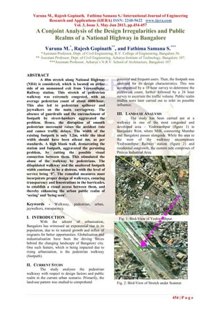
1. Varuna M., Rajesh Gopinath, Fathima Samana S./ International Journal of Engineering
Research and Applications (IJERA) ISSN: 2248-9622 www.ijera.com
Vol. 3, Issue 3, May-Jun 2013, pp.454-457
454 | P a g e
A Conjoint Analysis of the Design Irregularities and Public
Realms of a National Highway in Bangalore
Varuna M.*
, Rajesh Gopinath**
, and Fathima Samana S.***
*Assistant Professor, Dept. of Civil Engineering, R.V. College of Engineering, Bangalore 56.
** Assistant Professor, Dept. of Civil Engineering, Acharya Institute of Technology, Bangalore 107.
***Assistant Professor, Acharya‟s N.R.V. School of Architecture, Bangalore 107.
ABSTRACT
A 40m stretch along National Highway
(NH4) is considered, which is located on either
side of an unmanned exit from Yeswanthpur
Railway station. This stretch of pedestrian
walkway was extremely congested, with an
average pedestrian count of about 4000/hour.
This also led to pedestrian spillover and
jaywalkers on the main carriageway. The
absence of guardrails and the encroachment of
footpath by street-hawkers aggravated the
problem. Hence, the disruption of smooth
pedestrian movement raises the accident rate
and causes traffic delays. The width of the
existing footpath is only 1.2m, while the ideal
width should have been atleast 4m, as per
standards. A high blank wall, demarcating the
station and footpath, aggravated the persisting
problem, by cutting the possible visual
connection between them. This stimulated the
abuse of the walkway by pedestrians. The
dilapidated walkway and the unaltered footpath
width continue to be a distress, with the level of
service being ‘F’. The remedial measures must
incorporate proper design of walkways, ensuring
transparency and fenestrations in the barricades,
to establish a visual access between them, and
thereby enhancing the urban public realm of
‘seeing’ and ‘being seen’.
Keywords - Walkway, pedestrian, urban,
jaywalkers, transparency.
I. INTRODUCTION
With the advent of urbanisation,
Bangalore has witnessed an exponential rise in its
population, due to its natural growth and influx of
migrants for better opportunities. Globalisation and
industrialisation have been the driving forces
behind the changing landscape of Bangalore city.
One such feature, which is being impacted due to
rising urbanisation, is the pedestrian walkway
(footpath).
II. CURRENT STUDY
The study analyses the pedestrian
walkway with respect to design factors and public
realm in the current urban scenario. Primarily, the
land-use pattern was studied to comprehend
potential and frequent users. Then, the footpath was
analysed for its design characteristics. This was
accompanied by a 10 hour survey to determine the
pedestrian count, further followed by a 24 hour
survey to ascertain the traffic volume. Public realm
studies were later carried out to infer its possible
influence.
III. LAND-USE ANALYSIS
The study has been carried out at a
walkway in one of the most congested and
developed area – Yeshwanthpur (figure 1) in
Bangalore West, where NH4, connecting Mumbai
and Bangalore passes alongside. While the area to
the west of the walkway encompasses
Yeshwanthpur Railway station (figure 2) and
residential outgrowth, the eastern side comprises of
Peenya Industrial Area.
Fig. 1: Bird-View of Yeshwanthpur.
Fig. 2: Bird-View of Stretch under Scanner.
2. Varuna M., Rajesh Gopinath, Fathima Samana S./ International Journal of Engineering
Research and Applications (IJERA) ISSN: 2248-9622 www.ijera.com
Vol. 3, Issue 3, May-Jun 2013, pp.454-457
455 | P a g e
IV. SITE CHARACTERISTICS
The study basically visualizes 40m of the
walkway adjacent to an unmanned exit (figure 3)
from the Yeshwanthpur Railway station. The visual
access from the walkway to the rail terminal is
interrupted by a large blank wall. The walkway also
comprises of fruit vendors and other street hawkers,
luring the potential customers entering and leaving
the railway station.
The survey confirmed that the walkway
did not comply with the IRC standards, as its width
was only about 1.2m (figure 4) and also lacked
guardrails, compulsory requisite for all National
Highways. The level of service for the walkway
was found to be „F‟, which is the lowest rating, as
per Highway Capacity Manual (HCM) 2010. The
stretch parallel to the walkway also houses a petrol
bunk, an auto-rickshaw stand and an unsheltered
bus-stop, adding to larger agglomeration of public.
Under the current circumstances, with less width
and high pedestrian density, people often tend to
walk on the road to save time and avoid collisions
with other people, sharing the same space. This
causes pedestrian spillover onto the main
carriageway.
Fig. 3: The unmanned exit from railway station.
Fig. 4: The walkway under investigation.
V. PEDESTRIAN AND TRAFFIC ANALYSIS
As an intercity rail transit terminal, the
area is a major hub for people of all ages, classes
and occupations. In the survey conducted between
8:30AM–6:30PM on a weekday, the walkway was
found to be extremely congested with a maximum
pedestrian count of about 4000, and the pedestrian
walking speed reduced to as low as 0.54m/sec
during the peak hours. Even the space occupied by
the pedestrians dwindled from 0.18 to 0.08
m2/person, forcing spillover and jaywalkers (figure
5) with a disturbing hourly average pedestrian flow
of 26. The high frequency in usage may be
attributed to the fact, that apart from the railway
station, people from the surrounding residential and
industrial sectors also used the stretch to board and
alight from the buses. The pedestrian density was
found to vary from 5.3 to 11.42 person/m2, around
the peak hours.
Fig. 5: Traffic Disruption by pedestrians.
Fig. 6: Heavy traffic volume.
The width of the two-lane carriageway
was found to be 7m with the maximum users being
motor-bikes, followed by cars. The traffic volume
(figure 6) along the walkway was found to be
38,498 alongside a disturbing hourly average
pedestrian flow of 26. As there was no provision of
zebra-crossing and median, the unruly crossing
speed of pedestrians was found to be around
1m/sec, thereby interfering with the smooth flow of
traffic, leading to delays.
3. Varuna M., Rajesh Gopinath, Fathima Samana S./ International Journal of Engineering
Research and Applications (IJERA) ISSN: 2248-9622 www.ijera.com
Vol. 3, Issue 3, May-Jun 2013, pp.454-457
456 | P a g e
For every 1 minute, the vehicles were
found to be delayed by an average of 5 seconds,
thereby aggravating noise levels and vehicle
operating cost.
VI. PUBLIC REALM ANALYSIS
To aggravate the persisting problem of
jaywalkers and high pedestrian density, the high
blank wall demarcating the railway station and
footpath, cuts the possible visual connection
between the two, stimulating the abuse of the
walkways by pedestrians and its encroachment by
street hawkers (figure 7). As the other side is not
visible, due to the presence of a huge wall along the
footpath, the commuters or pedestrians tend to
blemish the walkway (figure 8), by disposing
garbage, spitting & urinating. Thereby, making the
walkway a misfit, failing to actually serve its
purpose. The use of walkway by pedestrians may
also be biased by factors such as adjacent land-
uses, its visual and physical connections with the
walkway and the prevailing condition of the
footpath. Instead of paintings and sticking pictures
of deities on the wall to sensitize public, it is better
to ensure cleanliness and hygiene, through
transparency and design.
Fig. 7: Encroachment along walkway.
Fig. 8: Public abuse & spillover along walkway.
VII. ENVIRONMENTAL ANALYSIS
The solutions, envisaged for the current
issue, have incorporated road widening, without
any regard or consideration for the roadside
elements contributing to the urban landscape. This
has severely impacted the natural environment and
elevated air pollution levels, compounding the loss
of trees, which act as natural air-purifiers. Metro
rail project, which has been initiated along this
stretch to reduce stress on transportation and
environment, has failed too, as it has added to the
present congestion. With the commencement of the
Metro construction, roads have deteriorated, with
the top layer of the tarred road (figure 9) being
worn out at several places causing dust pollution.
Potholes and bottlenecks, introduced by Metro
construction and its barricades have increased the
waiting time and crossing time of vehicles, thereby
hiking the rate of automobile exhaust.
Fig. 9: Widened Roads near stretch
Fig. 10: Flash Flooding, alongside walkway.
The area presently is a mute witness to Air
Quality Index (AQI) of 256, which incidentally
falls under the category/rating of „Severe Air
Pollution‟. Coincidentally, even the average daily
„maximum‟ and „minimum‟ noise levels have been
observed to be above 92 and 62 dB, both being
above city tolerance levels. All along this, the
stretch is already experiencing flash floods during
rainy seasons (figure 10), due to clogged drains,
compounded by the fact that it is located at a lower
4. Varuna M., Rajesh Gopinath, Fathima Samana S./ International Journal of Engineering
Research and Applications (IJERA) ISSN: 2248-9622 www.ijera.com
Vol. 3, Issue 3, May-Jun 2013, pp.454-457
457 | P a g e
level than the station. Along with all this, air
pollution levels are also further elevated.
VIII. RECOMMENDATIONS AND
DISCUSSION
The existing footpath width is only 1.2m,
whereas as per IRC standards, the ideal width
should have been atleast 4m with provisions of
guard rails and zebra-crossing, along with regular
maintenance of the road infrastructure. The
corrective measures must also incorporate
fenestrations in the barricades, to establish a visual
access, such that the link between them is enhanced
by the urban public realm. Since sky-walkers or
foot-over bridge cannot be incorporated with metro
being commissioned, an „I‟ shaped Subway (figure
11) having a width of 4m and vertical clearance of
atleast 2.5m, starting from the point of unmanned
exit, leading to the other side must be provided.
The subway apart from providing structural
stability and necessary safety measures for
pedestrians must also be pedestrian friendly,
promoting its use. The subways, instead of being
used solely for crossing can be made more
interesting with activities like informal hawking,
incorporated in the design itself. Informal hawking
in the subway would not only enrich the experience
of the pedestrians who use it, but also would help in
maintaining the place neat and clean.
Fig. 10: Proposed Subway.
IX. CONCLUSION
The study has revealed that the stretch
under investigation was inferior in all standards,
with respect to the service offered to pedestrians.
The high usage factor and the absence of guardrails
has further enhanced the problem of pedestrian
spillover and jaywalkers, disrupting the smooth
flow of traffic movement, raising the accident rate
and causing traffic delays by a maximum of 30
seconds per crossing.
The government initiated road widening at
the cost of roadside trees; all along with unaltered
footpath width has continued to contribute to the
spilling over of pedestrians onto the main
carriageway, aggravated by the dilapidated state of
walkway, as an outcome of pedestrian abuse and
encroachment by street hawkers. Recommendations
to counter the current situation, apart from
inclusions of corrective designs along with periodic
maintenance, also envisages provisions of grade
separated pedestrian facilities such as subway,
keeping public realm in mind.
REFERENCES
[1] W.J. Book, EIA Report of Metro Rail
Project for Bangalore City, 2010.
[2] IRC: 103-1988, “Guidelines for pedestrian
facilities”.
[3] Flaherty, “Transport Planning and Traffic
Engineering”, Butterworth-Heinemann,
1996.
[4] Chakraborty et al., “Facilities for
Pedestrian Movement in Metropolitan
centres”, IRC.
[5] Rakesh S., “Evaluation of the Pedestrian
Environment”, Chennai, 2003.