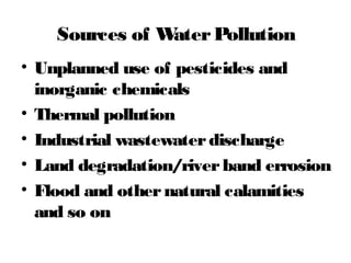
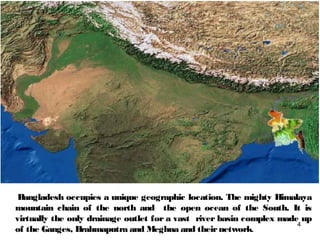
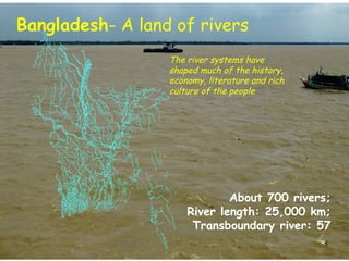
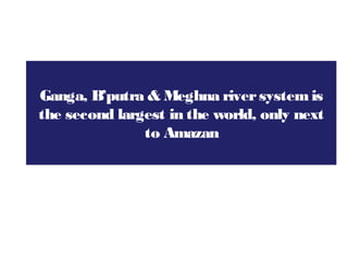
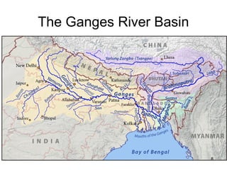
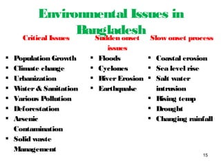
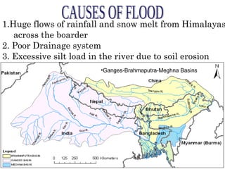
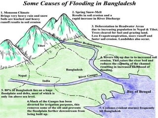
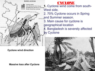
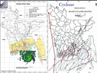
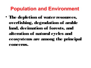
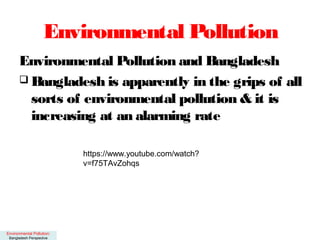
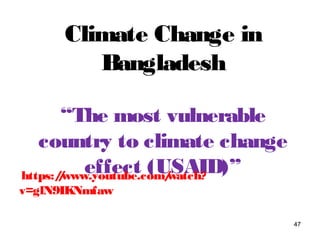
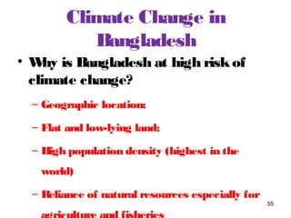
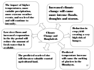
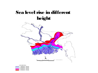
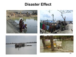
Bangladesh has a unique geographic location situated between the Himalayas and the Bay of Bengal. It has a vast river system composed of the Ganges, Brahmaputra, and Meghna rivers which shape the country's landscape, economy, and culture. However, this also makes Bangladesh vulnerable to flooding and transboundary issues due to upstream water management. Additionally, the country faces numerous environmental challenges such as population growth, urbanization, climate change, natural disasters, and various forms of pollution which threaten its environment. Proper management of water resources and mitigation of natural hazards are crucial for Bangladesh's sustainable development.
2. Bangladesh: Geographical Facts
Facts Facts Facts
Location: South
Asia
Area: 148,460 sq
km
Land boundary:
Burma 271 km&
India 4,142 km
Coastal line: 580
Territorial sea:
12nm, Economic
zone: 200 nm
Terrain: mostly
flat alluvial plain;
hilly in southeast,
also some part of
eastern &
southern portion
Landscapes:
Floodplains
(80%), terraces
(8%), hills (12%)
& other(8%)
Land:
Agricultural
(70.1%), Forest
(11.1%) & Other
18.8%
2
3. Bangladesh: Geography Facts
Facts Facts Facts
Hills: High hills
(over20 meters
altitude) in the
southeast, and low
hills (less than 20
meters) in the
northeast
Natural resources:
natural gas, arable
land, timber, coal,
waterresources etc.
Climate: Tropical;
mild winter
(Novemberto
February); hot,
humid summer
(March to June);
humid, warm
rainy monsoon
(June to October)
Seasons
(Meteorological &
Cropping):
Summer,
monsoon, winter
Net sown area:
17.5% single crop,
54.7% double crop
& 20.4% triple
crop
Natural resources:
natural gas,
arable land,
timber, coal,
waterresources
etc.
3
4. Bangladesh occupies a unique geographic location. The mighty Himalaya
mountain chain of the north and the open ocean of the South. It is
virtually the only drainage outlet for a vast river basin complex made up
of the Ganges, Brahmaputra and Meghna and theirnetwork.
4
5. Bangladesh- A land of rivers
The river systems have
shaped much of the history,
economy, literature and rich
culture of the people
About 700 rivers;
River length: 25,000 km;
Transboundary river: 57
5
6. Ganga, B’putra & Meghna riversystemis
the second largest in the world, only next
to Amazan
7. The Complex WaterSystem
1. Beels, baors, haors, rivers and
canals, floodplains, estuaries etc.
make up vast networkof wetlands
2. Bangladesh is located within the
largest delta that is continuously
being formed, along with heavy clay
soil making its rivers constantly
subject to change
3. Large areas are subject to annual7
9. Geographical Advantages
• Tropical climate favours high-yielding
agriculture possible
• Flatness of land, good soil, quantity of
waterare good assets forcultivation
• Bangladesh possesses a rich heritage of bio-
diversity. Population is heavily reliant on
management of natural resources, forests
and hill tracts fortheirlivelihood and
survival
• Extensive coastline opens access to
oceanfront resources, strategic importance,
9
11. Geographical Advantages
• Afterthe final settlement of
maritime borderdisputes with
Myanmarand India in 2012 and 2014
respectively, Bangladesh has
received entitlement to 118,813 sq.
kmcomprising herterritorial sea and
Exclusive Economic Zone (EEZ)
(MoFA, 2014)
• HUGE POTENTIAL FOR 11
12. International Politics of Water
Mgt
• Bangladesh is highly constrained
managing its waterneeds
• As a lower“riparian” country
Bangladesh is heavily vulnerable to the
downstreameffects of India’s water
management efforts
• Farakka barrage on Ganges built in
1974 became a source of political
tension
• In 1996 two countries signed 30 yr
12
13. International Politics of Water
Mgt
• Second disputes relates to Teesta, a
barrage built by Bangladesh in 1990
hampered operation while India built
barrage in upstream
• Tipaimukhydroelectric project is
anotherexample of India’s interference
with Bangladesh’s waterrights
13
16. 1.Huge flows of rainfall and snow melt from Himalayas
across the boarder
2. Poor Drainage system
3. Excessive silt load in the river due to soil erosion
•Ganges-Brahmaputra-Meghna Basins
17.
18. 1. Cyclone wind come from south-
West side.
2. 70% Cyclone occurs in Spring
and Summer season.
3. Main cause for cyclone is
geographical location
4. Bangladesh is severely affected
by Cyclone
Massive loss after Cyclone
Cyclone wind direction
CYCLONE
21. Suddenly Natural gas is coming out
EARTHQUAKE
1. We feel shake sometimes
2. Very densely populated area,
so any future earthquake will bring
serious affect
22. ------------------------------------------------------------------------------------------------------------
Date Name( Place) Magnitude Epicenter distance
in Richter from Dhaka (km)
------------------------------------------------------------------------------------------------------------
10 Jan 1869 Kachar earthquake 7.5 250
-----------------------------------------------------------------------------------------------------------------------
14 Jul 1885 Bengal earthquake(Bogra ) 7.0 170
----------------------------------------------------------------------------------------------------------------------
12 Jun 1897 Great Indian Earthquake 8.7 230
----------------------------------------------------------------------------------------------------------------------
08 Jul 1918 Srimangal Earthquake ( Srimangal) 7.6 150
----------------------------------------------------------------------------------------------------------------------
02 Jul 1930 Dhubri Earthquake 7.1 250
----------------------------------------------------------------------------------------------------------------------
15 Jan 1934 Bihar-Nepal Earthquake (Bihar) 8.3 510
----------------------------------------------------------------------------------------------------------------------
15 Aug 1950 Asam Earthquake (Asam) 8.5 780
------------------------------------------------------------------------------------------------------------------
08 May 1997 Sylhet Earthquake (Sylhet ) 6.0 210
----------------------------------------------------------------------------------------------------------------------
21 Nov 1997 Chittagong Earthquake (Chittagong) 8.5 264
----------------------------------------------------------------------------------------------------------------------
22 Jul 1999 Moheskhali Earthquake (Cox;s Bazar ) 5.2 300
----------------------------------------------------------------------------------------------------------------------
27-Jul 2003 Chittagong-Rangamati Earthquake 5.9 290
23. ------------------------------------------------------------------------------------------------------------
Date Name( Place) Magnitude Epicenter distance
in Richter from Dhaka (km)
------------------------------------------------------------------------------------------------------------
4 Jan 2016 Imphal /Nepal earthquake 6.7 352
-----------------------------------------------------------------------------------------------------------------------
13 April 2016 Myanmar 6.9 ---
----------------------------------------------------------------------------------------------------------------------
24. Bangladesh is divided into 3 earthquake
zones :
• Zone –1 : the less risky zone (includes
Jessore , Khulna and Barisal Dist .)
• Zone – 2 : medium vulnerable zone
(includes Dhaka ,Rajshahi , Dinajpur,
Bogra , Chittagong and Noakhali Dist.
• Zone – 3 : the most vulnerable zone
(includes Sylhet , Mymensingh and
Rangpur Districts.)
EARTHQUAKE ZONES IN BANGLADESH
25. TORNADO
1. Tornado occurs in
central
part of Bangladesh.
2. 75% Tornado occurs in
Monsoon season
3. People affected within a
few
minutes.
26. DROUGHT
# Drought occures in
Pre-
Monsoon time
# Lackof rain and
Moisture, the People
affected by Drought
# Sometimes, North-
west
And South-west
regions
affected by drought
The paddy field for over sunlight
27. RIVER BANK EROSION
Embankment broken by the river
1.River Bank Erosion causes in the
Rainy season.
3.About 1 million people affected by
this disaster in every year.
4.People migrate from one place to
another.
28. Solid waste creates problems primarily
in high-population areas
• Half of the solid waste comes from
household
• Dhaka city corporations can collect
42% of the total generated waste, the
rest lie on roadsides, open drains, low-
lying areas, orvacant lots
• More than 80% of the solid waste of
Dhaka city is organic in content which
has the potential to be used as
compost
SOLIDWASTE
30. • Arsenic is a white, semi-metallic powder
found in nature whose components are
highly toxic, can cause ulcer, cancer&
thickening of the skin
• Arsenic deposits have entered the
drinking water, entering the food
system, and cause various health
hazards
• Arsenic contamination in ground water
was first detected in 1993, 54 districts
are affected
ARSENIC CONTAMINATION IN
BANGLADESH
39. Population and Environment
• The depletion of waterresources,
overfishing, degradation of arable
land, decimation of forests, and
alteration of natural cycles and
ecosystems are among the principal
concerns.
40. Environmental Pollution
Environmental Pollution and Bangladesh
Bangladesh is apparently in the grips of all
sorts of environmental pollution & it is
increasing at an alarming rate
Environmental Pollution:
Bangladesh Perspective
https://www.youtube.com/watch?
v=f75TAvZohqs
42. AirPollution
Air pollution adversely affects the
respiratory tract, causes eye irritation,
headache, fatigue, asthma, hypertension
and cardiac problem
50 tons of lead are emitted annually in
Dhaka’s atmosphere, evidence of emission is
acute during dry season
Dhaka is one of the highly polluted cities in
the world in terms of airpollution
In urban area, automobiles & industrial
emissions cause air pollution, in rural area
43. Noise Pollution
Noise pollution leads to
Irritation and an increased blood pressure,
Loss of temper,
Decrease in workefficiency,
Loss of hearing
WHO(World Health Organization) has
prescribed optimumnoise level as 45 dBby day
and 35 dBby night. Anything above 80 dBis
hazardous
WHOat 45 locations of Dhaka city, most of the
traffic points and many of the industrial,
residential, commercial, silent and mixed areas are
44. WaterPollution
Addition orpresence of undesirable
substances in wateris called water
pollution
All types of water borne disease are the
ultimate results of polluted water
Due to water pollution, the life-cycle of
fish and other aquatic organism hamper
tremendously
https://www.youtube.com/watch?
v=1ZeY7AyfoqU
45. Sources of WaterPollution
• Unplanned use of pesticides and
inorganic chemicals
• Thermal pollution
• Industrial wastewaterdischarge
• Land degradation/riverband errosion
• Flood and othernatural calamities
and so on
46. Soil Pollution
• Addition of substances which adversely affect
the quality of soil or its fertility is known as soil
pollution
• Generally, polluted wateralso pollute soil
• Solid wastes that are the mixture of various
wastes are the primary cause of soil pollution
• Industrial wastes, fly ash and chemical from
agricultural sources are also potential sources
• Contribution of municipal wastes and land
fillings are the growing sources
47. Climate Change in
Bangladesh
“The most vulnerable
country to climate change
effect (USAID)”
47
https://www.youtube.com/watch?
v=glN9IKNmfaw
48. Scientific Basis of CC
One of the greatest threats to the humanity
today
Earlier it was perceived as an environmental
problem (GHG emission & temperature rise).
Now it is a developmental problem (poverty,
food/water, social securities, MDG/SDG
United Nations Framework Convention on
Climate Change (UNFCC) defines climate
change as the change resulting from long
term direct and indirect activities that
induces changes in the compared time which
49. Sources of GHGs & CO2
concentration
Fossil fuel burning
Industrialisaton and urbanisation
Unsustainable production and
consumption
Agriculture and forest depletion
Household energy consumption
Industrialised and rich countries are
mainly responsible forGHG emission
51. Largest emitters country
Source: CRS Report for Congress, 2008
Per capita emissions of CO2 is less than 0.2 ton annually in Bangladesh,
compared to 1.6 tons in the developing countries.
52. The globally averaged surface temperature is
projected to increase by 1.4 to 5.8 ºC overthe
period 1990 to 2100.
Global mean sea level is projected to rise by 0.09
to 0.88 mbetween the years 1990 and 2100.
Glaciers and ice caps are projected to continue
theirwidespread retreat during the 21st
Century.
Dry season flows of riverwill shrinkin future.
There will be erratic behaviorof weather
Likely Impacts
53. Dry seasons will have less rainfall. There
will be an increase in irrigation water
demand
Forests will be affected as climate changes
and plants will need time to adjust
Flora and fauna and theirinter-relationship
will be in jeopardy. Many species will
disappear, many will face problems in
surviving
Drought tolerant, saline tolerant and
submergence tolerant varieties of crops will
be required to cope with
Likely Impacts…..
54. Likely Impacts ……
Vulnerability to both flood and drought will
increase.
Riverflooding may increase in duration. Flash
flooding will be more frequent. Short duration
rainfalls may create drainage congestions
specially in urban areas.
A sea level rise of 0.5mby 2050 will cause low
lying coastal areas to go underwater. Small
island states may disappear.
Frequency of tropical cyclones will increase.
Stormsurge depths will increase.
55. Climate Change in
Bangladesh
• Why is Bangladesh at high riskof
climate change?
– Geographic location;
– Flat and low-lying land;
– High population density (highest in the
world)
– Reliance of natural resources especially for
55
57. The impact of higher
temperatures, more
variable precipitation,
more extreme weather
events, and sea level rise
and will continue to
intensify.
Increased climate
change will cause
more intense floods,
draughts and storms.
Reduction in
crop yield
creating a very
high riskof
hunger.
Low riverflows and
increased evaporation
in the dry period will
reduce the amount of
fresh waterthat is
available.
The predicted sea-level rise
will threaten valuable coastal
agricultural land.
Predicted
temperature increase
will cause the melting
of glaciers in the
Himalayas.
Climate
Change and
Bangladesh
57
60. - Every year, rivers engulf enormous
agriculture fields and homesteads, making
people homeless
- Migration to urban areas and live in slum
underunhygienic conditions
Climate Refugee orMigration
62. Adaptation & Mitigation
• Adaptation:
– Human adjustment with the changing environment
– Bangladesh always put emphasis on adaptation
– Example: Preparing cyclone shelter, Raising the
base of the house, changing consumption pattern
• Mitigation:
– Taking structural and nonstructural measures to
prevent disasteri.e. reducing carbon dioxide
emission.
– There is huge scope forBangladesh regarding
mitigation 62
67. Mitigation Potentials for
Bangladesh
• Transport Sector:
– Railway: Increasing and strengthening rail
network.1 train = 50 trucks
– Waterway: Maintaining navigability of rivers.
Securing rivertransportation.
• Residential Sector:
– Gas metering:
• 3 million domestic userof gas
• Flat rate forgas consumption leading to gas
wastage
67
68. Mitigation Potentials for
Bangladesh
• Residential Sector:
– Improve cookstoves: ICS increasing energy
efficiency by 20%.
– SolarPV
• Industry Sector:
– Efficient technologies
– Brickkilns: German Hybrid Hoffman Kiln
(HHK) Technology reduces coal consumption
by 20-30%
68
Global Carbon Dioxide Emissions, per country and per capita
This graphic from Time magazine (4/9/01 edition on global warming) illustrates global carbon dioxide emissions both by total tons emitted per country and total tons emitted per capita.
- The black smoke plumes show total CO2 emissions since 1950 in billions of tons: US/186.1 billion tons; Canada/14.9; Mexico/7.8; European Union/127.8; Russia/68.4; Ukraine/21.7; Poland/14.4; Kazakhstan/10.1; China/57.6; Japan/ 31.2; India/15.5; South Africa/8.5; and Australia/7.6
- The 3-D map shows yearly per capita carbon dioxide emissions in tons: red/16 to 36 tons per person; orange/7 to 16 tons; yellow/2.5 to 7 tons; dark green/0.8 to 2.5 tons; light green/0.1 to 0.8 tons; and light blue/0 to 0.1 tons.
Although the United States makes up only 4% of the world's total population, we produce nearly 25% of the world's greenhouse gases. In comparison, India, with over 1 billion people (~17% of the world’s population), is responsible for just over 2% of carbon dioxide emissions currently in the atmosphere, while China, the world’s most populous country, accounts for about 8.5% of emissions.
Data: World Resources Institute