Boundary island tourist area
•
0 likes•21 views

Hanjourney.com | Famous tourist attractions in China

Recommended
More Related Content
What's hot
What's hot (19)
Similar to Boundary island tourist area
Similar to Boundary island tourist area (20)
More from Journey Han
More from Journey Han (20)
Recently uploaded
Recently uploaded (20)
Boundary island tourist area
- 1. Boundary Island Tourist Area hanjourney.com
- 2. G eographic location:Lingdao County, Hainan Province Level:AAAAA Famous scenery:Marine Culture Museum, Beauty Island, Shenniu Mountain Suitable for the play season:Annual The border island is located on the southeastern coast of Hainan Island, about 1.2 nautical miles from the nearest coast of Hainan Island, and a one-way journey by boat for about 15 minutes. The island is located in the blue sea from the northeast to the southwest. It looks like a saddle in the distance, with an area of about 0.41 square kilometers and an altitude of 99 meters. The border island is under the jurisdiction of Lingshui Li Autonomous County, about 70 kilometers from Sanya and about 180 kilometers from Haikou. The Hainan Boundary Island Tourist Area opened on May 1, 2004. In January 2013, it was rated as a national 5A-level tourist scenic spot by the National Tourism Administration. It is China’s first island-type national 5A-level scenic spot. Surroundings The sky is sprinkled with pearls and naturally made. Because of the special geographical location, obvious climate change, unique island terrain, and distinctive regional cultural characteristics, Bianzhou Island has “demarcation island”, “beauty island”, “Maanling” and “sleeping” since ancient times. “Foshan” and other reputation. It’s refreshing and relaxing. On the Huandao East Line Expressway and
- 3. the East Ring Railway, you can see the full view of the border island in the blue sea. The spiritual sanctuary is divided into north and south. The beautiful border island is the dividing line between Hainan’s north and south climate. It is an important boundary between the ethnic minority areas of the Li, Miao and Hui nationalities in Hainan Island and the Han nationality. It is the natural geographical margin of Qiongnan and Qiongbei. It is the northern part of the old time. The boundary between the territory of Qiongzhou and the jurisdiction of Yazhou Prefecture in the south is also the administrative demarcation point between Lingshui County and Wanning City. It is also the “demarcation line of mind” that changes mood and understands life. Bihai Yuntian, Happy Island. Demarcation Island is located in the most beautiful sea. The boundary island not only provides visitors with conventional marine tourism such as diving, sea fishing, motorboats, but also provides intimacy with many marine animals (dolphins, sea lions, sea turtles, whale sharks, etc.). Interactive project.
- 4. Origin Niuling is also known as the Boundary Ridge, mainly because it is an important watershed in Hainan Island. Since ancient times, the local people have felt the difference between the north and the south of this mountain. In fact, the entire Niuling is a continuation of the Wuzhishan Mountains, which was formed by the extrusion of the continental plate hundreds of millions of years ago; the boundary island is also the lower part of the Niuling, and later the glacial period, the immersion of the sea, flooded The low part cut off the connection between the border island and Niuling, thus forming what it is. Although the entire Hainan Island is in the tropics, because of this north-southwest-oriented Niuling, the climate of this ridge is different. The climate north of Niuling is relatively warm, the humidity of the air is relatively high, and there is more rainfall. The temperature in Lingnan is two or three degrees higher than that in Lingbei. The sunshine is abundant, but it is dry and less rainy. Seeing the two sides of the Niu Ling on the border island, you can often see such a scene: the summer rains in the north of the ridge, the south of the ridge is sunny; the north of the ridge is cloudy in the north, while the south of the ridge is sunny.
- 5. Geographic location Geographically speaking, Niuling is the dividing line between Hainan Island’s north and south geography. There are more plains in the north and more mountains in the south. This geographical boundary has formed a climatic boundary. The heating flow from the south is separated from the east-west mountain range, causing the climate of the mountain slope (south) and the back slope (north) to differ, so that this small mountain has an impact on the climate in the southeast of Hainan Island. Because of this, standing on the border island, you can often see the wonders of Niuling’s “the head of the cow is raining, the tail of the ox.” Dijiezhou Island is located on the northeastern part of Lingshui County, covering an area of one square kilometer. It is about 8 nautical miles from the Niuling Tunnel of the Eastern Expressway. There are many rare plants and animals on the island. On the basis of the beginning of vegetation, the construction of the boundary island eco-tourism project.
- 6. History On April 27, 2004, a virgin island in the boundary between Lingshui County and Wanning City, Hainan Province, was finally opened to her mysterious veil. A group of tourists and tour guides took the lead in visiting this place. An uninhabited island called “Beauty Island”. Dijiezhou Island is located on the northeastern part of Lingshui County, about 8 nautical miles from the Niuling Tunnel of the Eastern Expressway. There are many rare plants and animals on the island. Since May 2002, it has invested more than 38 million yuan to build more than 400 acres of land on the island to build a boundary island eco-tourism project based on the maximum protection of the original vegetation. Name meaning Climate Dijiezhou Island is located in the sea at the junction of Lingshui and Wanning in Hainan Province. It is the extension of Niuling to the South China Sea. It is said that the entire Niuling is a continuation of the Wuzhishan Mountains, which was formed by the extrusion of the continental plate hundreds of millions of years ago. Divided Island is
- 7. the lower part of Niuling. Later, during the glacial period, the immersion of seawater inundated the lower part and cut off the connection between the border island and Niuling, thus forming the present. Although the whole island of Hainan is in the tropics, because the north is dominated by plain land types and the south is mountainous, the heating flow from the south is separated from the east-west mountain range, causing the mountain to meet the slope (south) and the back slope ( The climate in the north is different, so that this small mountain has an impact on the climate in the southeast of Hainan Island. It is precisely because of this that standing on the border island, you can often see the wonders of Niuling’s “the head of the cow is raining, the tail of the ox.” Administrative area Here is the boundary between the administrative areas of Wanning City and Lingshui County. Lingbei is Wanning City, Lingnan is Lingshui Li Autonomous County, and the boundary markers of two counties and cities are on this mountain.
- 8. Human boundaries The Boundary Ridge connects the Wuzhishan Mountains in the middle and the Yinggeling Ridge in the west, forming an east-west mountain that separates the north and south of Hainan Island. The natural boundary has also become the ancient Hainan humanistic boundary, which is the boundary between the Han and Li ethnic groups. The Li nationality and Lingbei are mainly Han people. Main Attractions The location of the dividing island is an important watershed in Hainan Island. The island is part of Niuling, and the climate varies greatly from north to south. Here you can often see the spectacle: in the summer, the rain in Lingbei, Lingnan is sunny; in winter, Lingbei
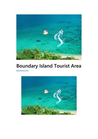
- 9. is cloudy, while Lingnan is sunny. The cliffs on the eastern side of the border island are like snow. On the west, there is a small bay with a gentle wave. The beach in the bay is soft and white. On the island, you will find the sea breeze from the vast sea of smoke, and there are coral reefs and tropical fish in the surrounding waters. Overnight on the island, you can listen to the sound of the tide, watch the fishing fire, watch the stars, is a good place to see the sunrise on the sea. Visitors can experience the once uninhabited islands and enjoy the adventures and adventures on uninhabited islands. It takes only 3 minutes by speedboat to get to the island. Followed by the “Qianlu” paved with granite carved from various dynasties of the dynasty at home and abroad, but the stone peaks are everywhere, the cliffs are numerous, and the odd trees are crowded. Some natural pinnacles have been nicknamed “Wind Stone”, “Wu Sha Cap”, “Da Dong Tian” and “Buddha Cave”. Standing on the top of the mountain, the sea around the border island is clear and connected with the beach, forming a natural picture that the painter can’t reach. The island was not smoked in the past, but after two years of careful development, it has now basically built a tropical tourist pocket, where people can relax and enjoy. There are more than 20 natural landscapes on the island, such as “Ghosts and Crafts”, “Dadongtian” and “Sycamore Huayan”. There are reef diving, cliff diving, wreck diving, sea motorboat, underwater walk, sea parachute, beach bar. With unique marine entertainment projects, visitors can experience unprecedented novelty and excitement. Divided Island was officially opened in May 2004 at the May 1st Golden Week. In the future, the boundary island will be connected with islands such as Sanya West Island, Wuzhizhou Island, Wanning Dazhou Island, and Lingshui Monkey Island to form a sea sightseeing tour route. Here you can often see the spectacle: in the summer, the rain in Lingbei, Lingnan is sunny. From a distance, the entire border island is like a beautiful woman lying on the sea, so it is also known as Sleeping Beauty Island. Because the temperature in the south of the Niuling Mountains is high, dry and rain-free, the north is warm and the humidity is too
- 10. high. Therefore, on the border island, you can often see the weather in the north and the rain in the south. Traffic Guide Train Haikou departure: From Haikou South Station and East Railway Station, take the bus to Wanning, transfer from Wanning, and take the bus to Sanya (Wanning – Sanya). The Haiqi Express starts at 08:15 every day. Every half an hour or so, there is a bus to Wanning. The journey is 151 kilometers. It takes 2 hours and the fare is 36 yuan/person. From Haikou South Station, take the Haikou–Lingshui or Haikou— Sanya’s bus, and start at the East Long-distance Bus Terminal in Haikou Province. The Haiqi Express starts at 08:15 every day. Every half an hour or so, there is a bus to Wanning. The journey is 151 kilometers. It takes 2 hours and the fare is 36 yuan/person. Then take the bus at the intersection of Wanning. Go to Lingshui’s ordinary CMB bus, get off at the expressway in front of Niuling Tunnel, take a trip of 33 kilometers, 30 minutes to arrive, Wanning to Lingshui 8 yuan /
- 11. person, in Niuling or Riyuewan Get off the bus and bargain to 5 yuan / person. Bus Sanya starting: Sanya to Wanning take the expressway, the whole journey is 127 kilometers, only the ordinary CMB bus, the earliest bus is at 07:00, the latest bus is 18:00, every half hour, one hour can arrive Niuling Expressway. Buy a ticket for Wanning, the fare is 20 yuan / person; Take the bus in Sanya—Haikou direction, you need to buy tickets to the Xinglong intersection, but you can get off at the exit of the Niuling Tunnel. Small reminder: Take the expressway for 3 minutes to get to the pier. It takes 3 minutes to take the boat on the border island, and the hull is stable. Return: Return to Wanning, Haikou or Lingshui, Sanya at the highway intersection Other ways to travel: Wanning, Xinglong, Shenzhou Peninsula, Shimei Bay and other places to recommend a package, contact Wanning Xinglong Island Tourism Service Center in advance to order a day trip package, including car transfer, tickets, marine culture, diving, lunch, The price of sea fishing, insurance, etc. is 558 yuan. The registration place is at the left counter in the lobby of Le Méridien Hotel in Shimei Bay.