1. Geography of Taiwan
Physical boundaries
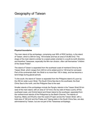
The main island of the archipelago, comprising over 99% of ROC territory, is the island
of Taiwan, which is 394 km long, 144 kmwide and has an area of 35,883 km2. The
shape of the main island is similar to a sweet potato oriented in a south-to-north direction,
and therefore Taiwanese, especially the Min-nan division, often call themselves "children
of the Sweet Potato".
The island of Taiwan is separated from the southeast coast of mainland China by the
Taiwan Strait, which ranges from 220 km at its widest point to 130 kmat its narrowest.
Part of the continental shelf, the Strait is no more than 100 m deep, and has become a
land bridge during glacial periods.
To the south, the island of Taiwan is separated from the Philippine island of Luzon by
the 250 km wide Luzon Strait. The South China Sea lies to the southwest, the East
China Sea to the north, and the Philippine Sea to the east
Smaller islands of the archipelago include the Penghu islands in the Taiwan Strait 50 km
west of the main island, with an area of 127 km2, the tiny islet of Hsiao Liuchiu off the
southwest coast, and Orchid Island and Green Island to the southeast, separated from
the northernmost islands of the Philippines by the Bashi Channel. The islands of
Quemoy, Matsu and Wuchiu near the coast of Fujian across the Taiwan Strait, with a
total area of 180 km2 and the Pratas and Taiping islets in the South China Sea, are also
administered by Taiwan, but are not part of the Taiwanese archipelago.
2. Terrain
The terrain in Taiwan is divided into two parts: the flat to gently rolling plains in the west,
where 90% of the population lives, and the mostly rugged forest-covered mountains in
the eastern two-thirds.
The eastern part of the island is dominated by five mountain ranges, each running from
north-northeast to south-southwest, roughly parallel to the east coast of the island.
The Central Mountain Range extends from Su-ao in the northeast to Eluanbi at the
southern tip of the island, forming a ridge of high mountains and serving as the island's
principal watershed. The mountains are predominantly composed of hard rock
formations resistant to weathering and erosion, although heavy rainfall has deeply
scarred the sides with gorges and sharp valleys.
Shiukuluan River in Hualien County
The East Coast Mountain Range extends down the east coast of the island from the
mouth of the Hualien River in the north to Taitung County in the south, and chiefly
consist of sandstone and shale. It is separated from the Central Range by the narrow
Huatung Valley, at an altitude of 120 m. Although Hsinkangshan, the highest peak,
reaches an elevation of 1,682 m most of the range is composed of large hills. Small
streams have developed on the flanks, but only one large river cuts across the range.
Badlands are located at the western foot of the range, where the ground water level is
the lowest and rock formations are the least resistant to weathering. Raised coral reefs
along the east coast and the frequent occurrences of earthquakes in the rift valley
indicate that the fault block is still rising.
The San Guang River in northwestern Taiwan
3. The Xueshan Range lies to the northwest of the Central Mountain Range, beginning at
Sandiaojiao, the northeast tip of the island, and gaining elevation as it extends
southwest towards Nantou County. Xueshan, the main peak, is 3,886 m high.
The Yushan Range runs along the southwestern flank of the Central Range. It includes
the island's tallest peak, the 3,952 m.Jade Mountain which makes Taiwan the world's
fourth-highest island.
Paddy fields in Yilan County
The Alishan Range lies west of the Yushan Range, across the valley of the south-flowing
Kaoping River. The range has major elevations between 1,000 and 2,000 m. The main
peak, Data Mountain, towers 2,663 m
Human geography
Taiwan has a population of over 23 million, the vast majority of whom live in the lowlands
near the western coast of the island. The island is highly urbanized, with nearly 9 million
people living in the Taipei–Keelung–Taoyuan metropolitan area at the northern end, and
over 2 million each in the urban areas of Kaohsiung and Taichung.
Han Chinese make up over 95% of the population. Immigrants from southern Fujian
began to farm the area around modern Tainan and Kaohsiung from the 17th century,
later spreading across the western and northern plains and absorbing the aboriginal
population of those areas. Hakka people from eastern Guangzhou arrived later and
settled the foothills further inland, but the rugged uplands of the eastern half of the island
remained the exclusive preserve of the aborigines until the early 20th century. A further
1.3 million people from throughout mainland China entered Taiwan at the end of the
Chinese Civil War in 1949.