SlideShare a Scribd company logo
1 of 12
Download to read offline
G
Cocoto Sea Scenic Area
eographic location:5 km west of Coco Tohai
Town, Fuyun County, Altay Region
Level:AAAAA
hanjourney.com
Famous scenery:Coco Suli, Karajangel, Irtysh Grand
Canyon
Suitable for the play season:August to October
Coco Tuohai Scenic Area and Xinjiang Coco Tohai National Geological
Park is located in Fuyun County, Altay Prefecture, northern Xinjiang,
covering an area of 788 square kilometers, 485 kilometers away from
Urumqi and 53 kilometers away from Fuyun County. The scenic area
consists of four parts: the Irtysh Grand Canyon, the Coco Suli, the
Iremut Lake, and the Karasenger earthquake fault zone. It uses
beautiful canyon rivers, mountain woodland, mineral resources, cold
lakes and strange earthquake fault zones as natural scenery,
integrating geological culture, regional characteristics and national
customs, with sightseeing, leisure and special tourism (hiking, Large-
scale tourist attractions with main features such as photography and
scientific research.
In 2012, the Cocoto Sea Scenic Area was promoted to the national 5A
level tourist attraction.
Historical evolution
The Cocotohai mining area was discovered in 1930, when only the
local ethnic minorities mined the outcrop part of the No. 3 vein, and
the products were used as jewelry decoration materials.
In 1935, two geological units of the former Soviet government came
to Altay. After several geological explorations, the No. 3 vein was
mainly used for trial mining in the Cocotohai mining area, and beryl
and coltan were mined.
On March 1, 1950, the “Ashan Mine Management Office of Sino-Soviet
Nonferrous Metals and Rare Metals Co., Ltd.” was established.
On January 1st, 1955, all the enterprises in the mining area were
handed over to China to operate independently. The former Ashan
Mine Management Office was renamed as the Noncoferrous Metals
Management Bureau of the Ministry of Metallurgical Industry,
Xinjiang Nonferrous Metals Co., Ltd., which is directly under the
central management.
In 1958, it was renamed the Cocoto Sea Mining Bureau.
In 2005, the Cocoto Sea Scenic Area was officially approved by the
Ministry of Land and Resources as a national geological park.
On July 15, 2008, the Coco Tohai National Geological Park officially
opened.
In 2009, it was assessed as a 4A-level scenic spot by the National
Tourism Administration Tourist Area (Point) Quality Rating
Committee.
In early 2010, it was awarded the honorary title of “10 Excellent
A-level Scenic Spots in Xinjiang” by the Tourism Bureau of Xinjiang
Autonomous Region. It was awarded the honorary title of
“International Original Eco-tourism Scenic Spot” by the United
Nations Tourism Economic Promotion Association, China Marketing
Association and China Tourism Brand Association.
In 2010, Fuyun County invested 36.78 million yuan to improve the
Coca-Tuohai comprehensive reception center hotel and simple
restaurant, Zhongshan Road to the hot springs, scenic area signage,
scenic ticket inspection system and environmental protection
ecological toilet, scenic fast food service center and geology
Infrastructure such as museums and spa treatment centers.
On May 19, 2012, the Cocoto Seaview District was promoted to the
National 5A Tourist Attractions.
In 2013, Fuyun County invested 40 million yuan to develop and
construct ethnic speciality bars, open buffet dining areas, cross-river
sightseeing suspension bridges, tourist souvenirs, strange stones,
gem shops, outdoor amusement facilities and other service facilities.
Geographical environment
Location horizon
Cocoto Sea Scenic Area, located in Fuyun County, Altay Prefecture,
northern Xinjiang, covers an area of 788 square kilometers, 485
kilometers away from Urumqi and 53 kilometers away from Fuyun
County.
Topography
The Cocoto Sea Tourism Scenic Area is located in the middle
mountain belt of the southern slope of the Altay Mountains. The sea
level is 1200-1500 meters. Due to special geological structures, wind
and rain erosion and water cutting, many deep trench canyons are
formed. The Cocoto Sea View area is dominated by granite landforms.
Climate
The Cocoto Sea has a high dimension, deep inland and far away from
the ocean, forming a typical continental cold and arid climate, which
is cold in winter and cool in summer. In summer, the rain is long and
the winter wind is mostly snowy. The coldest month is January, the
average temperature is minus 37 °C, the extreme minimum
temperature is minus 51.5 °C (January 1961); the hottest month is
July, the average temperature is 25 °C, and the extreme maximum
temperature is 37 °C. Its extreme minimum temperature (minus 51.5
degrees Celsius) is second only to Mohe County in Heilongjiang
Province (the extreme minimum temperature is minus 52.3 °C), and it
is called the second cold pole in China. The average annual
precipitation of the Cocoto Sea is 250mm, and the annual average
wind speed is 1.4m/s. The dominant wind direction is the northwest
wind. The depth of the frozen soil is 2.2 meters and the frost-free
period is 120 days.
Natural resources
Mineral resources
As of 2013, there are more than 80 kinds of mines in Cocoto,
including lithium, antimony, bismuth, antimony, bismuth and
antimony. Among them, the reserves of antimony rank first in the
world. Gemstones such as emeralds, aquamarines and emeralds,
amethysts, hibiscus stones, garnets, tourmalines, etc. are produced in
granitic pegmatites.
Biological resources
As of 2013, there are more than 100 rare wild animals in the Cocoto
Sea, including brown bears, wild donkeys, beavers, snow leopards,
saigas, etc. There are dozens of wild plants such as wild lavender,
Lonicera japonica, Spiraea, Siberia. Juniper, all kinds of lichens and
moss, berberine, peony, Xinjiang Codonopsis, Altay alone.
Scenic spots
Coco Suri
Cocoa Suri is located in the northeast of the Tulhong Basin in Fuyun
County. The lake covers an area of 2 square kilometers and has a
water depth of 2 meters. It is a natural marsh wetland formed by the
melting snow of the surrounding mountains. The lake is clear and
blue. Rich in vivid plants. Every summer and autumn, a large number
of red geese, white swan, gray cranes, sand gulls, wild ducks, etc.
gather here to prosper. In the autumn, the reeds of the lake are open,
and more than 20 reed islands float in the wind, and the dense wild
ducks play and play.
Iremu Lake
Lake Iremu is located at the intersection of the Irtysh River and the
Kayil River. The lake covers an area of 212.5 square kilometers, with
an altitude of 1,120 meters, with a storage capacity of 113 million
cubic meters and a depth of about 100 meters. It is huge from the air.
The “8” shape is the largest dammed lake in the Fuyun earthquake.
The peaks on both sides of the lake stand tall, surrounded by green
trees on both sides of the north and south, and the fields are inlaid.
The center of the lake was cut off by most of the two mountains.
Karasenger earthquake fault zone
The Karasenger earthquake fault zone is located 30 kilometers
southeast of Fuyun County. It is the remains of the 1913 Fuyun
earthquake and is one of the rare earthquake fault zones in the world.
The earthquake has spread to the whole world, and the area with
obvious earthquakes is 2,500 kilometers in diameter. It leaves a
spectacular subsidence area of 1500 meters long and 350 meters wide
in the center of Karajanger. The hard rock layer is shattered by a
width of 6 meters and a depth of 10 The trench of Yumi, the mountain
that stretches more than 20 kilometers, is down 10 meters in total,
accompanied by earthquake relics such as ridges, beaded faults,
drums, and fissures. The remains have been preserved to date and
have geological research, scientific investigations, and eco-tourism.
Longmen Square
The Longmen Square is located at the entrance to the Irtysh Grand
Canyon Scenic Area. The mountains are connected to the Irtysh River
at the beginning and end, and the mountains surround the square. It
consists of four parts: Tourist Service Center and Geological Museum,
Main Monument Square, Ecological Parking Lot and Leisure Square.
Birch forest
The birch forest grows on the bank of the Irtysh River, covering an
area of 1.5 square kilometers. It consists of three different types of
white birch. It is dominated by birch trees, and the Siberian bitter
poplar is the second. The forest is cold and temperate. Leaves
secondary forest.
Flower field
Baihuacao Farm is located in the Irtysh Grand Canyon in the Cocoto
Sea Scenic Area, Fuyun County, Xinjiang. The clear amount of river
water flows from its west side. There are flowers such as gypsophila,
wild rapeseed, azalea, wild chrysanthemum, and thorns.
Canyon Granite Scenic Area
The Canyon Granite Scenic Area is located on the banks of the Irtysh
River in the Cocoto Sea Scenic Area in Fuyun County, Xinjiang. It is
mainly a number of pictographs on both sides of the road from
Shenzhongshan to Jirande Hot Spring. They are collectively called
“Gorge Granite Scenic Area”. “. There are waterfall fossils, two huge
gneiss granites, fairy chairs and inverted boots. There are also many
rocks like small animals, such as: giant pythons, elephant trunks,
camel peaks, eagle peaks, human head horses, Noah’s Ark.
Shenzhongshan
Shenzhongshan, also known as Amir Sarah, is a bell-like granite peak.
It is pulled up on the south bank of the foreshore, with an altitude of
1608 meters and a relative height difference of 365 meters. It is the
highest mountain view of the Altai Mountains. Birch, pine, and
Siberian spruce grow on the rock wall. Due to the concentric circular
layered joints on the parallel slopes of the rock mass, the joints along
the parallel slopes are continuously detached from the disintegration
and collapse due to the cold and weathering, so that the surface of the
mountain is both round and smooth, and it is very steep, thus forming
a bell-like shape. Landform.
Travel Information
Ticket information
The ticket price for the scenic spot is 90 yuan/person, and the ticket
for the section is 36 yuan/person (the gate-Zhongshan)
Travel information
Traveling by car: Take the Urumqi City-Rizigou Bus Station in Urumqi
City, take the Fuyun County Long-distance Bus, and arrive at Fuyun
County, then take the Fuyun County-Cocoto Sea Line Taxi (Fuyun Bus
Terminal) and arrive. Cocoto sea. Or take the Urumqi City-Cocotohai
Town Line long-distance bus and arrive at Cocotohai Town.
Self-driving tour: Drive from Urumqi to the happy intersection of
Fukang City, along the 216 National Road, from Urumqi City – Wucai
Bay – Kara Miri Hoofed Wildlife Sanctuary (here there are wild
horses, yellow sheep and other protected animals) ) – Chakultu (there
is a toll station, usually for lunch here) – Fuyun County (along the
provincial road 226 line) – Coco Tuohai Town (you can enjoy Cocoa
Suri and Iremu Lake along the way) Beautiful view).


More Related Content

What's hot (8)

Orange island scenic area
Orange island scenic areaOrange island scenic area
Orange island scenic area
 
Dreams
Dreams Dreams
Dreams
 
Trip to Taiwan
Trip to TaiwanTrip to Taiwan
Trip to Taiwan
 
Environmental and socio-economic study on St. martin, Moheshkhali & Cox’s baz...
Environmental and socio-economic study on St. martin, Moheshkhali & Cox’s baz...Environmental and socio-economic study on St. martin, Moheshkhali & Cox’s baz...
Environmental and socio-economic study on St. martin, Moheshkhali & Cox’s baz...
 
Geological field report_on_salt_range_333
Geological field report_on_salt_range_333Geological field report_on_salt_range_333
Geological field report_on_salt_range_333
 
Japan Ecotourism1
Japan Ecotourism1Japan Ecotourism1
Japan Ecotourism1
 
Gulangyu wanshishan scenic area
Gulangyu wanshishan scenic areaGulangyu wanshishan scenic area
Gulangyu wanshishan scenic area
 
Qinghai lake scenic spot, qinghai province
Qinghai lake scenic spot, qinghai provinceQinghai lake scenic spot, qinghai province
Qinghai lake scenic spot, qinghai province
 

Similar to Cocoto sea scenic area

Similar to Cocoto sea scenic area (20)

Bosten lake scenic area
Bosten lake scenic areaBosten lake scenic area
Bosten lake scenic area
 
Yuntaishan world geopark
Yuntaishan world geoparkYuntaishan world geopark
Yuntaishan world geopark
 
Fujian taining world geological park
Fujian taining world geological parkFujian taining world geological park
Fujian taining world geological park
 
Kunming city,stone forest scenic
Kunming city,stone forest scenicKunming city,stone forest scenic
Kunming city,stone forest scenic
 
Dongjiang lake scenic area
Dongjiang lake scenic areaDongjiang lake scenic area
Dongjiang lake scenic area
 
Huanglong scenic area
Huanglong scenic areaHuanglong scenic area
Huanglong scenic area
 
Chongqing yunyang longgang national geological park
Chongqing yunyang longgang national geological parkChongqing yunyang longgang national geological park
Chongqing yunyang longgang national geological park
 
Wulingyuan tourist area
Wulingyuan tourist areaWulingyuan tourist area
Wulingyuan tourist area
 
Maiji mountain scenic area
Maiji mountain scenic areaMaiji mountain scenic area
Maiji mountain scenic area
 
Longtan grand canyon scenic area
Longtan grand canyon scenic areaLongtan grand canyon scenic area
Longtan grand canyon scenic area
 
Jinfo mountain scenic area
Jinfo mountain scenic areaJinfo mountain scenic area
Jinfo mountain scenic area
 
Boundary island tourist area
Boundary island tourist areaBoundary island tourist area
Boundary island tourist area
 
Tianshan grand canyon
Tianshan grand canyonTianshan grand canyon
Tianshan grand canyon
 
Sichuan hailuogou national forest park
Sichuan hailuogou national forest parkSichuan hailuogou national forest park
Sichuan hailuogou national forest park
 
Taibai mountain national forest park
Taibai mountain national forest parkTaibai mountain national forest park
Taibai mountain national forest park
 
Lijiang yulong snow mountain scenic area
Lijiang yulong snow mountain scenic areaLijiang yulong snow mountain scenic area
Lijiang yulong snow mountain scenic area
 
Black valley scenic spot
Black valley scenic spotBlack valley scenic spot
Black valley scenic spot
 
Libo zhangjiang scenic area
Libo zhangjiang scenic areaLibo zhangjiang scenic area
Libo zhangjiang scenic area
 
Guilin lijiang scenic area
Guilin lijiang scenic areaGuilin lijiang scenic area
Guilin lijiang scenic area
 
Suzhou wuzhong taihu tourist area
Suzhou wuzhong taihu tourist areaSuzhou wuzhong taihu tourist area
Suzhou wuzhong taihu tourist area
 

More from Journey Han

More from Journey Han (20)

Shanghai science and technology museum
Shanghai science and technology museumShanghai science and technology museum
Shanghai science and technology museum
 
Shanghai wild animal park
Shanghai wild animal parkShanghai wild animal park
Shanghai wild animal park
 
The oriental pearl radio & tv tower
The oriental pearl radio & tv towerThe oriental pearl radio & tv tower
The oriental pearl radio & tv tower
 
Taihu shantouyu scenic area
Taihu shantouyu scenic areaTaihu shantouyu scenic area
Taihu shantouyu scenic area
 
Zhenjiang mountain scenic area
Zhenjiang mountain scenic areaZhenjiang mountain scenic area
Zhenjiang mountain scenic area
 
Dafeng zhonghua elk garden scenic spot, yancheng city, jiangsu province
Dafeng zhonghua elk garden scenic spot, yancheng city, jiangsu provinceDafeng zhonghua elk garden scenic spot, yancheng city, jiangsu province
Dafeng zhonghua elk garden scenic spot, yancheng city, jiangsu province
 
Maoshan moutain
Maoshan moutainMaoshan moutain
Maoshan moutain
 
Tianmu lake tourist resort
Tianmu lake tourist resortTianmu lake tourist resort
Tianmu lake tourist resort
 
The classical gardens of suzhou
The classical gardens of suzhouThe classical gardens of suzhou
The classical gardens of suzhou
 
Nantong city luohe scenic area
Nantong city luohe scenic areaNantong city luohe scenic area
Nantong city luohe scenic area
 
Jinji lake scenic area
Jinji lake scenic areaJinji lake scenic area
Jinji lake scenic area
 
Jiangsu jiangyan lake national wetland park
Jiangsu jiangyan lake national wetland parkJiangsu jiangyan lake national wetland park
Jiangsu jiangyan lake national wetland park
 
Changzhou universal dinosaur city
Changzhou universal dinosaur cityChangzhou universal dinosaur city
Changzhou universal dinosaur city
 
Tong li ancient town
Tong li ancient townTong li ancient town
Tong li ancient town
 
Slender west lake
Slender west lakeSlender west lake
Slender west lake
 
Confucian temple
Confucian templeConfucian temple
Confucian temple
 
Wuxi lingshan scenic area
Wuxi lingshan scenic areaWuxi lingshan scenic area
Wuxi lingshan scenic area
 
Zhouzhuang town
Zhouzhuang townZhouzhuang town
Zhouzhuang town
 
Root palace buddhist cultural tourism zone
Root palace buddhist cultural tourism zoneRoot palace buddhist cultural tourism zone
Root palace buddhist cultural tourism zone
 
Lu xun native place
Lu xun native placeLu xun native place
Lu xun native place
 

Recently uploaded

sample sample sample sample sample sample
sample sample sample sample sample samplesample sample sample sample sample sample
sample sample sample sample sample sample
Casey Keith
 
Four Famous Temples In Jammu and Kashmir
Four Famous Temples In Jammu and KashmirFour Famous Temples In Jammu and Kashmir
Four Famous Temples In Jammu and Kashmir
SuYatra
 

Recently uploaded (20)

abortion pills in Riyadh+966572737505 Cytotec Riyadh
abortion pills in  Riyadh+966572737505    Cytotec Riyadhabortion pills in  Riyadh+966572737505    Cytotec Riyadh
abortion pills in Riyadh+966572737505 Cytotec Riyadh
 
Explore Dubai with - Forever Tourism
Explore  Dubai  with  -  Forever  TourismExplore  Dubai  with  -  Forever  Tourism
Explore Dubai with - Forever Tourism
 
PLACE OF ATTRACTION IN LESOTHO Sani Pass
PLACE OF ATTRACTION IN LESOTHO Sani PassPLACE OF ATTRACTION IN LESOTHO Sani Pass
PLACE OF ATTRACTION IN LESOTHO Sani Pass
 
TOURISM ATTRACTIONS IN LESOTHO BY RAISI.
TOURISM ATTRACTIONS IN LESOTHO BY RAISI.TOURISM ATTRACTIONS IN LESOTHO BY RAISI.
TOURISM ATTRACTIONS IN LESOTHO BY RAISI.
 
Water Parks In Dubai.pdf Visit Whith Captain Dunes
Water Parks In Dubai.pdf Visit Whith Captain DunesWater Parks In Dubai.pdf Visit Whith Captain Dunes
Water Parks In Dubai.pdf Visit Whith Captain Dunes
 
Explore the Rich History of Northeast Sicily
Explore the Rich History of Northeast SicilyExplore the Rich History of Northeast Sicily
Explore the Rich History of Northeast Sicily
 
Sun World Bana Hills, Vienam Part 2 (越南 巴拿山太陽世界 下集).ppsx
Sun World Bana Hills, Vienam Part 2  (越南 巴拿山太陽世界 下集).ppsxSun World Bana Hills, Vienam Part 2  (越南 巴拿山太陽世界 下集).ppsx
Sun World Bana Hills, Vienam Part 2 (越南 巴拿山太陽世界 下集).ppsx
 
Myanmar 80 Greetings and colors from Myanmar
Myanmar 80 Greetings and colors from MyanmarMyanmar 80 Greetings and colors from Myanmar
Myanmar 80 Greetings and colors from Myanmar
 
The impact development on dams and mines
The impact development on dams and minesThe impact development on dams and mines
The impact development on dams and mines
 
sample sample sample sample sample sample
sample sample sample sample sample samplesample sample sample sample sample sample
sample sample sample sample sample sample
 
Elevate Your Busy Season Email Marketing, Holly May Webinar.pptx
Elevate Your Busy Season Email Marketing, Holly May Webinar.pptxElevate Your Busy Season Email Marketing, Holly May Webinar.pptx
Elevate Your Busy Season Email Marketing, Holly May Webinar.pptx
 
Overview of Lesotho 's natural beauty tourist attractions
Overview of Lesotho 's natural beauty tourist attractionsOverview of Lesotho 's natural beauty tourist attractions
Overview of Lesotho 's natural beauty tourist attractions
 
Four Famous Temples In Jammu and Kashmir
Four Famous Temples In Jammu and KashmirFour Famous Temples In Jammu and Kashmir
Four Famous Temples In Jammu and Kashmir
 
TOURISM -ATTRACTIONS- IN LESOTHO FOR YOU
TOURISM -ATTRACTIONS- IN LESOTHO FOR YOUTOURISM -ATTRACTIONS- IN LESOTHO FOR YOU
TOURISM -ATTRACTIONS- IN LESOTHO FOR YOU
 
How to Find Cheap Flight Tickets to Hyderabad.pptx
How to Find Cheap Flight Tickets to Hyderabad.pptxHow to Find Cheap Flight Tickets to Hyderabad.pptx
How to Find Cheap Flight Tickets to Hyderabad.pptx
 
Your Complete Guide to Neem Karoli Baba Ashram at Kainchi Dham in 2024.pdf
Your Complete Guide to Neem Karoli Baba Ashram at Kainchi Dham in 2024.pdfYour Complete Guide to Neem Karoli Baba Ashram at Kainchi Dham in 2024.pdf
Your Complete Guide to Neem Karoli Baba Ashram at Kainchi Dham in 2024.pdf
 
Tourism in Lesotho by Boitumelo Ntlhane.pptx
Tourism in Lesotho by Boitumelo Ntlhane.pptxTourism in Lesotho by Boitumelo Ntlhane.pptx
Tourism in Lesotho by Boitumelo Ntlhane.pptx
 
TOURISM ATTRACTION IN LESOTHO 2024.Pptx.
TOURISM ATTRACTION IN LESOTHO 2024.Pptx.TOURISM ATTRACTION IN LESOTHO 2024.Pptx.
TOURISM ATTRACTION IN LESOTHO 2024.Pptx.
 
TOURISM ATTRACTION IN LESOTHO 2024.pptx.
TOURISM ATTRACTION IN LESOTHO 2024.pptx.TOURISM ATTRACTION IN LESOTHO 2024.pptx.
TOURISM ATTRACTION IN LESOTHO 2024.pptx.
 
Tourism attractions in Lesotho e.g dam
Tourism attractions in  Lesotho  e.g damTourism attractions in  Lesotho  e.g dam
Tourism attractions in Lesotho e.g dam
 

Cocoto sea scenic area

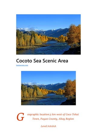
  • 1. G Cocoto Sea Scenic Area eographic location:5 km west of Coco Tohai Town, Fuyun County, Altay Region Level:AAAAA hanjourney.com
  • 2. Famous scenery:Coco Suli, Karajangel, Irtysh Grand Canyon Suitable for the play season:August to October Coco Tuohai Scenic Area and Xinjiang Coco Tohai National Geological Park is located in Fuyun County, Altay Prefecture, northern Xinjiang, covering an area of 788 square kilometers, 485 kilometers away from Urumqi and 53 kilometers away from Fuyun County. The scenic area consists of four parts: the Irtysh Grand Canyon, the Coco Suli, the Iremut Lake, and the Karasenger earthquake fault zone. It uses beautiful canyon rivers, mountain woodland, mineral resources, cold lakes and strange earthquake fault zones as natural scenery, integrating geological culture, regional characteristics and national customs, with sightseeing, leisure and special tourism (hiking, Large- scale tourist attractions with main features such as photography and scientific research. In 2012, the Cocoto Sea Scenic Area was promoted to the national 5A level tourist attraction. Historical evolution The Cocotohai mining area was discovered in 1930, when only the local ethnic minorities mined the outcrop part of the No. 3 vein, and the products were used as jewelry decoration materials. In 1935, two geological units of the former Soviet government came to Altay. After several geological explorations, the No. 3 vein was mainly used for trial mining in the Cocotohai mining area, and beryl and coltan were mined. On March 1, 1950, the “Ashan Mine Management Office of Sino-Soviet Nonferrous Metals and Rare Metals Co., Ltd.” was established. On January 1st, 1955, all the enterprises in the mining area were handed over to China to operate independently. The former Ashan Mine Management Office was renamed as the Noncoferrous Metals
  • 3. Management Bureau of the Ministry of Metallurgical Industry, Xinjiang Nonferrous Metals Co., Ltd., which is directly under the central management. In 1958, it was renamed the Cocoto Sea Mining Bureau. In 2005, the Cocoto Sea Scenic Area was officially approved by the Ministry of Land and Resources as a national geological park. On July 15, 2008, the Coco Tohai National Geological Park officially opened. In 2009, it was assessed as a 4A-level scenic spot by the National Tourism Administration Tourist Area (Point) Quality Rating Committee. In early 2010, it was awarded the honorary title of “10 Excellent A-level Scenic Spots in Xinjiang” by the Tourism Bureau of Xinjiang Autonomous Region. It was awarded the honorary title of “International Original Eco-tourism Scenic Spot” by the United Nations Tourism Economic Promotion Association, China Marketing Association and China Tourism Brand Association. In 2010, Fuyun County invested 36.78 million yuan to improve the Coca-Tuohai comprehensive reception center hotel and simple restaurant, Zhongshan Road to the hot springs, scenic area signage, scenic ticket inspection system and environmental protection ecological toilet, scenic fast food service center and geology Infrastructure such as museums and spa treatment centers. On May 19, 2012, the Cocoto Seaview District was promoted to the National 5A Tourist Attractions. In 2013, Fuyun County invested 40 million yuan to develop and construct ethnic speciality bars, open buffet dining areas, cross-river sightseeing suspension bridges, tourist souvenirs, strange stones, gem shops, outdoor amusement facilities and other service facilities.
  • 4. Geographical environment Location horizon Cocoto Sea Scenic Area, located in Fuyun County, Altay Prefecture, northern Xinjiang, covers an area of 788 square kilometers, 485 kilometers away from Urumqi and 53 kilometers away from Fuyun County. Topography The Cocoto Sea Tourism Scenic Area is located in the middle mountain belt of the southern slope of the Altay Mountains. The sea level is 1200-1500 meters. Due to special geological structures, wind and rain erosion and water cutting, many deep trench canyons are formed. The Cocoto Sea View area is dominated by granite landforms.
  • 5. Climate The Cocoto Sea has a high dimension, deep inland and far away from the ocean, forming a typical continental cold and arid climate, which is cold in winter and cool in summer. In summer, the rain is long and the winter wind is mostly snowy. The coldest month is January, the average temperature is minus 37 °C, the extreme minimum temperature is minus 51.5 °C (January 1961); the hottest month is July, the average temperature is 25 °C, and the extreme maximum temperature is 37 °C. Its extreme minimum temperature (minus 51.5 degrees Celsius) is second only to Mohe County in Heilongjiang Province (the extreme minimum temperature is minus 52.3 °C), and it is called the second cold pole in China. The average annual precipitation of the Cocoto Sea is 250mm, and the annual average wind speed is 1.4m/s. The dominant wind direction is the northwest wind. The depth of the frozen soil is 2.2 meters and the frost-free period is 120 days.
  • 6. Natural resources Mineral resources As of 2013, there are more than 80 kinds of mines in Cocoto, including lithium, antimony, bismuth, antimony, bismuth and antimony. Among them, the reserves of antimony rank first in the world. Gemstones such as emeralds, aquamarines and emeralds, amethysts, hibiscus stones, garnets, tourmalines, etc. are produced in granitic pegmatites. Biological resources As of 2013, there are more than 100 rare wild animals in the Cocoto Sea, including brown bears, wild donkeys, beavers, snow leopards, saigas, etc. There are dozens of wild plants such as wild lavender, Lonicera japonica, Spiraea, Siberia. Juniper, all kinds of lichens and moss, berberine, peony, Xinjiang Codonopsis, Altay alone.
  • 7. Scenic spots Coco Suri Cocoa Suri is located in the northeast of the Tulhong Basin in Fuyun County. The lake covers an area of 2 square kilometers and has a water depth of 2 meters. It is a natural marsh wetland formed by the melting snow of the surrounding mountains. The lake is clear and blue. Rich in vivid plants. Every summer and autumn, a large number of red geese, white swan, gray cranes, sand gulls, wild ducks, etc. gather here to prosper. In the autumn, the reeds of the lake are open, and more than 20 reed islands float in the wind, and the dense wild ducks play and play.
  • 8. Iremu Lake Lake Iremu is located at the intersection of the Irtysh River and the Kayil River. The lake covers an area of 212.5 square kilometers, with an altitude of 1,120 meters, with a storage capacity of 113 million cubic meters and a depth of about 100 meters. It is huge from the air. The “8” shape is the largest dammed lake in the Fuyun earthquake. The peaks on both sides of the lake stand tall, surrounded by green trees on both sides of the north and south, and the fields are inlaid. The center of the lake was cut off by most of the two mountains. Karasenger earthquake fault zone The Karasenger earthquake fault zone is located 30 kilometers southeast of Fuyun County. It is the remains of the 1913 Fuyun earthquake and is one of the rare earthquake fault zones in the world. The earthquake has spread to the whole world, and the area with obvious earthquakes is 2,500 kilometers in diameter. It leaves a spectacular subsidence area of 1500 meters long and 350 meters wide in the center of Karajanger. The hard rock layer is shattered by a width of 6 meters and a depth of 10 The trench of Yumi, the mountain that stretches more than 20 kilometers, is down 10 meters in total, accompanied by earthquake relics such as ridges, beaded faults, drums, and fissures. The remains have been preserved to date and have geological research, scientific investigations, and eco-tourism.
  • 9. Longmen Square The Longmen Square is located at the entrance to the Irtysh Grand Canyon Scenic Area. The mountains are connected to the Irtysh River at the beginning and end, and the mountains surround the square. It consists of four parts: Tourist Service Center and Geological Museum, Main Monument Square, Ecological Parking Lot and Leisure Square. Birch forest The birch forest grows on the bank of the Irtysh River, covering an area of 1.5 square kilometers. It consists of three different types of white birch. It is dominated by birch trees, and the Siberian bitter poplar is the second. The forest is cold and temperate. Leaves secondary forest.
  • 10. Flower field Baihuacao Farm is located in the Irtysh Grand Canyon in the Cocoto Sea Scenic Area, Fuyun County, Xinjiang. The clear amount of river water flows from its west side. There are flowers such as gypsophila, wild rapeseed, azalea, wild chrysanthemum, and thorns. Canyon Granite Scenic Area The Canyon Granite Scenic Area is located on the banks of the Irtysh River in the Cocoto Sea Scenic Area in Fuyun County, Xinjiang. It is mainly a number of pictographs on both sides of the road from
  • 11. Shenzhongshan to Jirande Hot Spring. They are collectively called “Gorge Granite Scenic Area”. “. There are waterfall fossils, two huge gneiss granites, fairy chairs and inverted boots. There are also many rocks like small animals, such as: giant pythons, elephant trunks, camel peaks, eagle peaks, human head horses, Noah’s Ark. Shenzhongshan Shenzhongshan, also known as Amir Sarah, is a bell-like granite peak. It is pulled up on the south bank of the foreshore, with an altitude of 1608 meters and a relative height difference of 365 meters. It is the highest mountain view of the Altai Mountains. Birch, pine, and Siberian spruce grow on the rock wall. Due to the concentric circular layered joints on the parallel slopes of the rock mass, the joints along the parallel slopes are continuously detached from the disintegration and collapse due to the cold and weathering, so that the surface of the mountain is both round and smooth, and it is very steep, thus forming a bell-like shape. Landform.
  • 12. Travel Information Ticket information The ticket price for the scenic spot is 90 yuan/person, and the ticket for the section is 36 yuan/person (the gate-Zhongshan) Travel information Traveling by car: Take the Urumqi City-Rizigou Bus Station in Urumqi City, take the Fuyun County Long-distance Bus, and arrive at Fuyun County, then take the Fuyun County-Cocoto Sea Line Taxi (Fuyun Bus Terminal) and arrive. Cocoto sea. Or take the Urumqi City-Cocotohai Town Line long-distance bus and arrive at Cocotohai Town. Self-driving tour: Drive from Urumqi to the happy intersection of Fukang City, along the 216 National Road, from Urumqi City – Wucai Bay – Kara Miri Hoofed Wildlife Sanctuary (here there are wild horses, yellow sheep and other protected animals) ) – Chakultu (there is a toll station, usually for lunch here) – Fuyun County (along the provincial road 226 line) – Coco Tuohai Town (you can enjoy Cocoa Suri and Iremu Lake along the way) Beautiful view). 