17 December 2019
Mr.Ben CHAN Siu-bun
Assistant Director / Survey and Mapping
Survey and Mapping Office
Lands Department
Construction Innovation Expo 2019
BIM and GIS for Digital Hong Kong
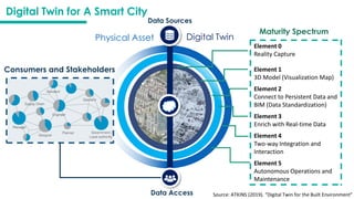
Data Access
Maturity Spectrum
DigitalTwin for A Smart City
Source: ATKINS (2019). “Digital Twin for the Built Environment”
Physical Asset Digital Twin
Element 0
Reality Capture
Element 1
3D Model (Visualization Map)
Element 2
Connect to Persistent Data and
BIM (Data Standardization)
Element 3
Enrich with Real-time Data
Element 4
Two-way Integration and
Interaction
Element 5
Autonomous Operations and
Maintenance
Data Sources
Consumers and Stakeholders
5.
Survey and MappingOffice
Lands Department
5
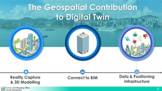
Data & Positioning
Infrastructure
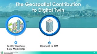
The Geospatial Contribution
to Digital Twin
Connect to BIM
Reality Capture
& 3D Modelling
6.
Survey and MappingOffice
Lands Department
6
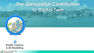
The Geospatial Contribution
to Digital Twin
Reality Capture
& 3D Modelling
7.
Survey and MappingOffice
Lands Department
7
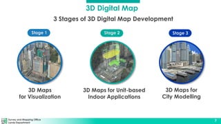
3 Stages of 3D Digital Map Development
3D Maps
for Visualization
3D Maps for Unit-based
Indoor Applications
Stage 2
Stage 1 Stage 3
3D Maps for
City Modelling
3D Digital Map
8.
Survey and MappingOffice
Lands Department
8
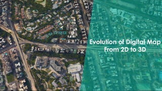
Evolution of Digital Map
From 2D to 3D
9.
Survey and MappingOffice
Lands Department
9
Stage 1 – 3D Maps for Visualization
10.
Survey and MappingOffice
Lands Department
10
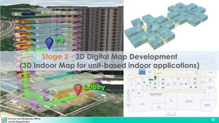
Stage 2 - 3D Digital Map Development
(3D Indoor Map for unit-based indoor applications)
11.
Survey and MappingOffice
Lands Department
11
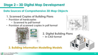
2. Digital Building Plans
• In CAD format
3. Building Information Modelling Models
1. Scanned Copies of Building Plans
• Provision of hardcopies
• Scanned to pdf format
• Provision of scanned copies in pdf format
Data Sources of Comprehensive 3D Map Objects
Stage 2 – 3D Digital Map Development
12.
Survey and MappingOffice
Lands Department
12
Top View
Plumbing
Fixtures
Generic
Models
Top View
AC Platform
Window Grill
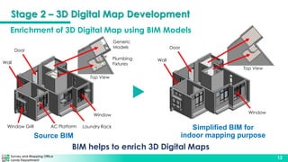
Enrichment of 3D Digital Map using BIM Models
Source BIM
BIM helps to enrich 3D Digital Maps
Simplified BIM for
indoor mapping purpose
Laundry Rack
Door
Window
Door
Wall
Window
Wall
Stage 2 – 3D Digital Map Development
13.
Survey and MappingOffice
Lands Department
13
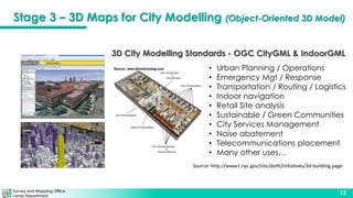
3D City Modelling Standards - OGC CityGML & IndoorGML
• Urban Planning / Operations
• Emergency Mgt / Response
• Transportation / Routing / Logistics
• Indoor navigation
• Retail Site analysis
• Sustainable / Green Communities
• City Services Management
• Noise abatement
• Telecommunications placement
• Many other uses…
Source: http://www1.nyc.gov/site/doitt/initiatives/3d-building.page
Stage 3 – 3D Maps for City Modelling (Object-Oriented 3D Model)
Survey and MappingOffice
Lands Department
15
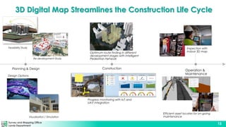
3D Digital Map Streamlines the Construction Life Cycle
Planning & Design Construction
Operation &
Maintenance
Feasibility Study
Design Options
Visualisation / Simulation
Progress monitoring with IoT and
UAV integration
Optimum route finding in different
development stages with Intelligent
Pedestrian Network
Inspection with
indoor 3D map
Re-development Study
Efficient asset locates for on-going
maintenance
16.
Survey and MappingOffice
Lands Department
16
Connect to BIM
Reality Capture
& 3D Modelling
The Geospatial Contribution
to Digital Twin
17.
Survey and MappingOffice
Lands Department
17
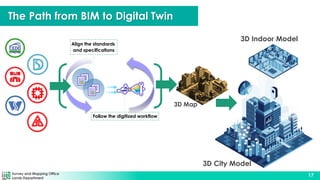
Align the standards
and specifications
Follow the digitized workflow
3D City Model
3D Indoor Model
The Path from BIM to Digital Twin
3D Map
18.
Survey and MappingOffice
Lands Department
18
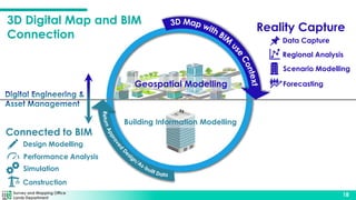
Geospatial Modelling
Building Information Modelling
Reality Capture
Data Capture
Regional Analysis
Scenario Modelling
Forecasting
Connected to BIM
Design Modelling
Performance Analysis
Simulation
Construction
3D Digital Map and BIM
Connection
19.
Survey and MappingOffice
Lands Department
19
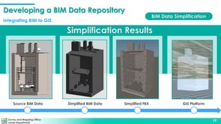
Simplification Results
Simplified BIM Data
Source BIM Data Simplified FBX GIS Platform
BIM Data Simplification
Developing a BIM Data Repository
Integrating BIM to GIS
20.
Survey and MappingOffice
Lands Department
20
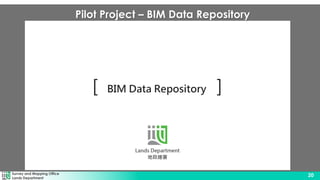
Pilot Project – BIM Data Repository
21.
Survey and MappingOffice
Lands Department
21
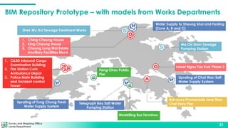
BIM Repository Prototype – with models from Works Departments
Shek Wu Hui Sewage Treatment Works
Water Supply to Sheung Shui and Fanling
(Zone A, B and C)
Ma On Shan Sewage
Pumping Station
Uprating of Chai Wan Salt
Water Supply System
Telegraph Bay Salt Water
Pumping Station
Uprating of Tung Chung Fresh
Water Supply System
Modelling Bus Terminus
Peng Chau Public
Pier
1. Ching Cheung House
2. King Cheung House
3. Cheung Lung Wai Estate
Ancillary Facilities Block
1. C&ED Inbound Cargo
Examination Building
2. Fire Station Cum
Ambulance Depot
3. Police Main Building
and Incident control
Tower
Lower Ngau Tau Kok Phase 2
Advance Promenade near Wan
Chai Ferry Pier
22.
Survey and MappingOffice
Lands Department
22
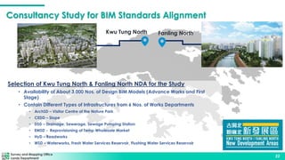
Consultancy Study for BIM Standards Alignment
Survey and Mapping Office
Lands Department
22
Selection of Kwu Tung North & Fanling North NDA for the Study
• Availability of About 3,000 Nos. of Design BIM Models (Advance Works and First
Stage)
• Contain Different Types of Infrastructures from 6 Nos. of Works Departments
• ArchSD – Visitor Centre of the Nature Park
• CEDD – Slope
• DSD – Drainage, Sewerage, Sewage Pumping Station
• EMSD - Reprovisioning of Temp Wholesale Market
• HyD – Roadworks
• WSD – Waterworks, Fresh Water Services Reservoir, Flushing Water Services Reservoir
Kwu Tung North Fanling North
23.
Survey and MappingOffice
Lands Department
23
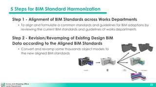
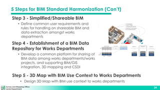
5 Steps for BIM Standard Harmonization
Step 1 - Alignment of BIM Standards across Works Departments
• To align and formulate a common standards and guidelines for BIM adoptions by
reviewing the current BIM standards and guidelines of works departments
Step 2 - Revision/Revamping of Existing Design BIM
Data according to the Aligned BIM Standards
• Convert and revamp some thousands object models to
the new aligned BIM standards
24.
Survey and MappingOffice
Lands Department
24
Step 3 - Simplified/Shareable BIM
• Define common user requirements and
rules for handling on shareable BIM and
data extraction amongst works
departments
Step 4 - Establishment of a BIM Data
Repository for Works Departments
• Develop a common platform for sharing of
BIM data among works departments/works
projects, and supporting BIM/GIS
integration, 3D mapping and CSDI
Step 5 - 3D Map with BIM Use Context to Works Departments
• Design 3D Map with BIM use context to works departments
5 Steps for BIM Standard Harmonization (Con’t)
25.
Survey and MappingOffice
Lands Department
25
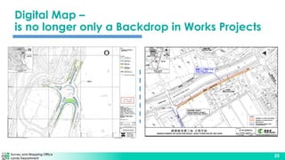
Digital Map –
is no longer only a Backdrop in Works Projects
26.
Survey and MappingOffice
Lands Department
26
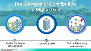
Data & Positioning
Infrastructure
Connect to BIM
Reality Capture &
3D Modelling
The Geospatial Contribution
to Digital Twin
27.
Survey and MappingOffice
Lands Department
27
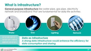
What is Infrastructure?
General purpose infrastructure like water pipe, gas pipe, electricity
network and broadband that are fundamental for daily life activities
Water Gas Lighting Network
1010101001001011
101011011100101011011111001010101011011100101011011111001010101011011100101011011111
10100010110101011
Data as Infrastructure
A strong data infrastructure would enhance the efficiency for
data consumption and sharing
28.
Survey and MappingOffice
Lands Department
28
Data as Infrastructure
Data informs how infrastructure is built, managed and
eventually decommissioned, and real-time data can
inform how infrastructure is operated on a second-to-
second basis.
Data is now as much a critical component of
infrastructure as steel, bricks and mortar. Data is part of
infrastructure and needs maintenance in the same way
that physical infrastructure needs maintenance
Source: National Infrastructure Commission, British
Data creates value: leveraging data to get more
out of infrastructure
29.
Survey and MappingOffice
Lands Department
29
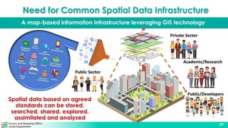
A map-based information infrastructure leveraging GIS technology
Need for Common Spatial Data Infrastructure
Public/Developers
Public Sector
Private Sector
Academic/Research
Spatial data based on agreed
standards can be stored,
searched, shared, explored,
assimilated and analyzed
30.
Survey and MappingOffice
Lands Department
30
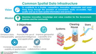
Maximise innovation, knowledge and value creation for the Government,
business and the community
Mission
Vision
To contribute to a livable, competitive, innovative, sustainable and smart
Hong Kong through the provision of convenient, easily accessible, high
quality and up-to-date spatial information and services
5 Objectives
Increase accessibility and
usability of spatial data
Enhance data
interoperability
Promote the use of
geospatial intelligence
and applications
Improve geospatial
capability and
knowledge
Foster a
collaborative culture
Systems
Users
Clearing
House
Common Spatial Data Infrastructure
31.
Survey and MappingOffice
Lands Department
31
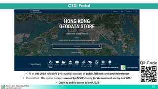
• As at Dec 2019, released 140+ spatial datasets of public facilities and land information
• Committed: 70+ spatial datasets owned by DEVB’s family for Government use by end 2021
• Open to public access by end 2022
CSDI Portal
QR Code
32.
Survey and MappingOffice
Lands Department
32
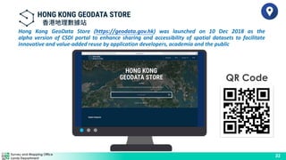
Hong Kong GeoData Store (https://geodata.gov.hk) was launched on 10 Dec 2018 as the
alpha version of CSDI portal to enhance sharing and accessibility of spatial datasets to facilitate
innovative and value-added reuse by application developers, academia and the public
QR Code
33.
Survey and MappingOffice
Lands Department
33
Hong Kong GeoData Store (https://geodata.gov.hk) was launched on 10 Dec 2018 as the
alpha version of CSDI portal to enhance sharing and accessibility of spatial datasets to facilitate
innovative and value-added reuse by application developers, academia and the public
QR Code
34.
Survey and MappingOffice
Lands Department
34
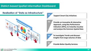
District-based Spatial Information Dashboard
02
05
01
Support Smart City Initiatives
Provide an Innovative & Interactive
Approach, using Key Performance
Indicators (KPIs), to instantly visualize
and analyse the Common Spatial Data
03 To investigate Trends and discover
Insights from large volumes of data
04
Provide Better Quality Services
Realization of “Data as Infrastructure”
35.
Survey and MappingOffice
Lands Department
35
District-based Spatial Information Dashboard
36.
Survey and MappingOffice
Lands Department
36
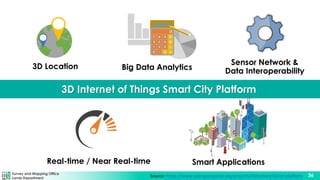
Source: https://www.opengeospatial.org/projects/initiatives/3d-iot-platform
3D Internet of Things Smart City Platform
3D Location
Sensor Network &
Data Interoperability
Big Data Analytics
Real-time / Near Real-time Smart Applications
37.
Survey and MappingOffice
Lands Department
37
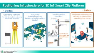
• Outdoor • Indoor
Ubiquitous Positioning and
Mobile Location-based
Services (Under Study)
LED light
Camera
Sensors
Location Devices
(Geo-marker, RFID,
Bluetooth Beacon,
etc.)
Wi-Fi / 5G
Bluetooth
Detector
Smart Lamp Post
(Trial Run)
Meteorological &
Air Quality Sensors
Positioning Infrastructure for 3D IoT Smart City Platform
Geodetic Network
Over 5500 Control Stations Covering
Territory-wide Hong Kong
Hong Kong
Satellite Positioning
Reference Station Network
(SatRef)
38.
Survey and MappingOffice
Lands Department
38
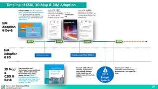
How Government Takes the Initiatives?
39.
Survey and MappingOffice
Lands Department
39
Policy Address Jan 2017 and Oct
2017, Promote the establishment of
CSDI; Actively seek to require
consultants and contractors to use
BIM technology, Implement Open
Data Policy
Issue of TC 7/2017
Adoption of Building
Information Modelling
for Capital Works
Projects in Hong Kong
ADV034 on BIM
2018
2017
Issue of TC 18/2018
Adoption of Building
Information Modelling for
Capital Works Projects in
Hong Kong
2019 2020
Practice note PNAP ADM-2
Issue of
Construction
2.0
The Innovation and
Technology Bureau published
in Dec 2017 the Smart City
Blueprint for Hong Kong
setting out the overall
framework and strategy for
developing Hong Kong into a
Smart City – including CSDI,
3D Map and BIM.
2019
Budget
Speech
Earmark $300 million to
develop a geospatial
data sharing platform
(CSDI Portal) and 3D
digital maps of the whole
territory
Steering Committee on
Innovation and Technology
endorsed the CSDI Paper on 3
June
BIM
Adoption
@ BD
BIM
Adoption
@ DevB
3D Map
&
CSDI @
DevB
Timeline of CSDI, 3D Map & BIM Adoption
40.
Survey and MappingOffice
Lands Department
40
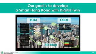
Our goal is to develop
a Smart Hong Kong with Digital Twin
CSDI
3D Map
BIM