
Recommended
More Related Content
Similar to application of airborne lidar in detecting forest structure
Similar to application of airborne lidar in detecting forest structure (20)
Recently uploaded
Recently uploaded (20)
application of airborne lidar in detecting forest structure
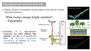
- 1. Advantage of high resolution lidar data Availability of a high‐resolution topography data (from airborne lidar scanning ) will able us to quantify the effect of fine‐scale topographic heterogeneity on variation of canopy height at landscape scale. Ground points- last return Canopy layer- first return DSM – Digital surface model CHM – Canopy height model DTM – Digital terrain model Spatial variation of maximum canopy height are key drivers of many ecosystem processes. What creates canopy height variation? - Topography.
- 2. 2 Key questions……. 1. Topographical features (elevation, slope, aspect, topographic convexity, and topographic wetness index) We are interested in……… 2. Canopy gap position 3. Neighborhood tree density Influence canopy height.
- 3. Study area Kyoto city Total study area is ~ 230 sq km.
- 4. Explanatory variables 3-d image Canopy height Ground elevation Slope Aspect Topographic wetness index Canopy gap Neighboring tree density Topographic curvature
- 5. Explanatory variables 3-d image Canopy height Ground elevation Slope Aspect Topographic wetness index Canopy gap Neighboring tree density Topographic curvature High value low value Gap detection Tree top detection ~14 million tree
- 6. Canopy height and elevation Canopy height and topographic curvature
- 7. Canopy height and distance from gap Canopy height and neighboring tree density
- 8. Importance of explanatory variables on canopy height variation
- 9. Summary In addition to topographic heterogeneity, canopy gap position and neighboring tree density drives canopy height. However, including all the variables can only describe 40% of canopy height variation. So there may be other factors like stand age, soil drive canopy height variation at landscape level. This study was conducted in temperate region but many of the techniques can be used in tropical regions too.
Editor's Notes
- Variation of vertical forest structure is one of the feature that drive many ecosystem process. SO many of us are interested about what cause canopy height variation. The most obvious answer is topography. But the if we have the previlage to derive topographic data it will be very easy for us to quantify the effect of fine scale topography on canopy height at landscape level. This is a schematic diagram where it shows how it can capture the height data, ground elevation.