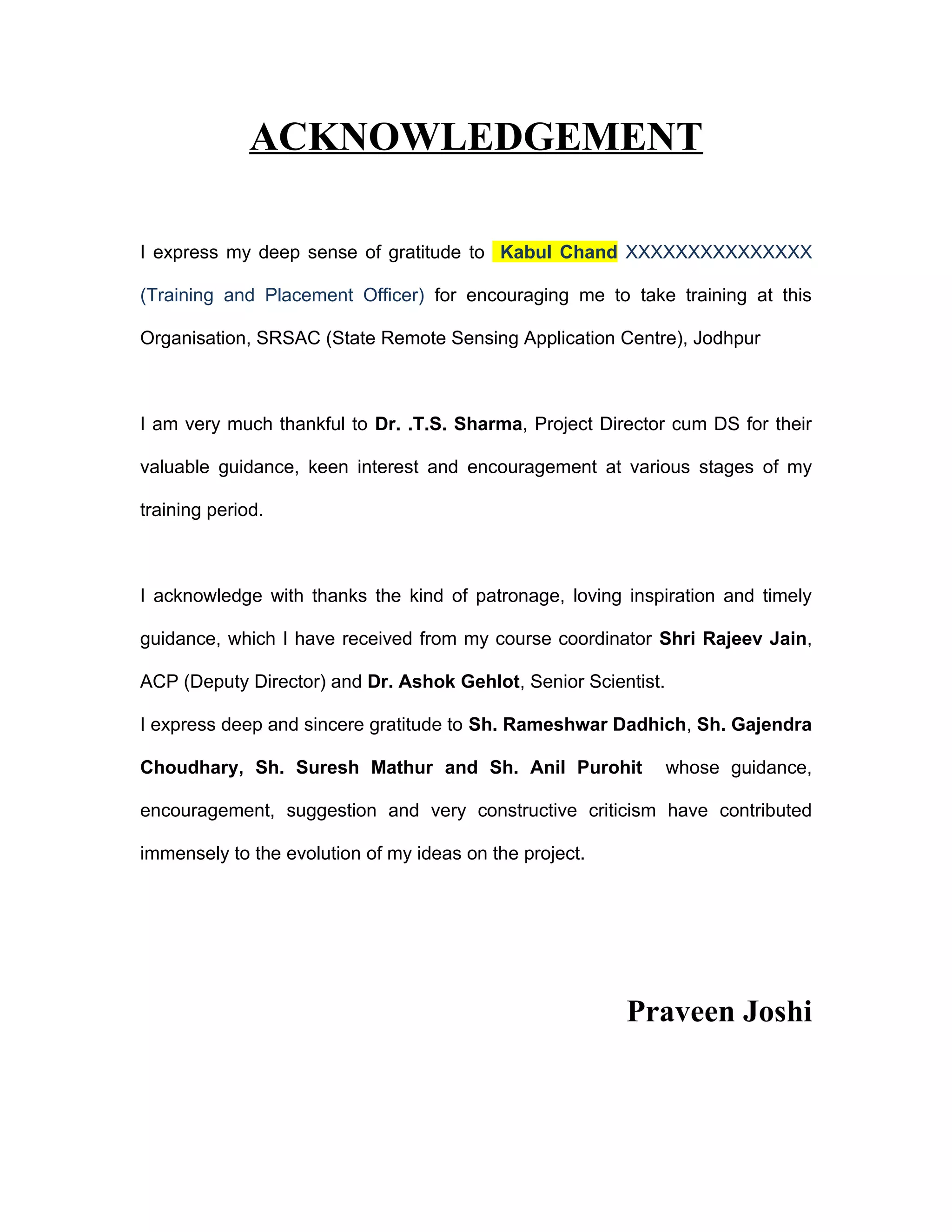
ACKNOWLEDGEMENT

I express my deep sense of gratitude to Kabul Chand XXXXXXXXXXXXXXX

(Training and Placement Officer) for encouraging me to take training at this

Organisation, SRSAC (State Remote Sensing Application Centre), Jodhpur


I am very much thankful to Dr. .T.S. Sharma, Project Director cum DS for their

valuable guidance, keen interest and encouragement at various stages of my

training period.


I acknowledge with thanks the kind of patronage, loving inspiration and timely

guidance, which I have received from my course coordinator Shri Rajeev Jain,

ACP (Deputy Director) and Dr. Ashok Gehlot, Senior Scientist.

I express deep and sincere gratitude to Sh. Rameshwar Dadhich, Sh. Gajendra

Choudhary, Sh. Suresh Mathur and Sh. Anil Purohit               whose guidance,

encouragement, suggestion and very constructive criticism have contributed

immensely to the evolution of my ideas on the project.


                                                         Praveen Joshi
Contents

1. Basic In Remote Sensing
   Introduction
   Remote Sensing System
     Remote Sensing Platforms
     Applications of Remote Sensing
     Indian Satellites
     Important Abbreviations
     Characteristics of Satellite

2. Image Processing

   Introduction
   Image Processing Overview.
   Classification of Processor.
   Orbital Characteristics
   Elements of Interpretations
   Techniques of Image Interpretation.

3. Geographical Information System

   Introduction
   Components of GIS.
   Data Structure of GIS.

4. Introduction To ARC/INFO

   What is ARC/INFO ?
5. State Remote Sensing Application Centre


6. My Project

  • Remote sensing database management
Acknowledgement

Acknowledgement

  • 1.
    ACKNOWLEDGEMENT I express mydeep sense of gratitude to Kabul Chand XXXXXXXXXXXXXXX (Training and Placement Officer) for encouraging me to take training at this Organisation, SRSAC (State Remote Sensing Application Centre), Jodhpur I am very much thankful to Dr. .T.S. Sharma, Project Director cum DS for their valuable guidance, keen interest and encouragement at various stages of my training period. I acknowledge with thanks the kind of patronage, loving inspiration and timely guidance, which I have received from my course coordinator Shri Rajeev Jain, ACP (Deputy Director) and Dr. Ashok Gehlot, Senior Scientist. I express deep and sincere gratitude to Sh. Rameshwar Dadhich, Sh. Gajendra Choudhary, Sh. Suresh Mathur and Sh. Anil Purohit whose guidance, encouragement, suggestion and very constructive criticism have contributed immensely to the evolution of my ideas on the project. Praveen Joshi
  • 3.
    Contents 1. Basic InRemote Sensing  Introduction  Remote Sensing System  Remote Sensing Platforms  Applications of Remote Sensing  Indian Satellites  Important Abbreviations  Characteristics of Satellite 2. Image Processing  Introduction  Image Processing Overview.  Classification of Processor.  Orbital Characteristics  Elements of Interpretations  Techniques of Image Interpretation. 3. Geographical Information System  Introduction  Components of GIS.  Data Structure of GIS. 4. Introduction To ARC/INFO  What is ARC/INFO ?
  • 4.
    5. State RemoteSensing Application Centre 6. My Project • Remote sensing database management