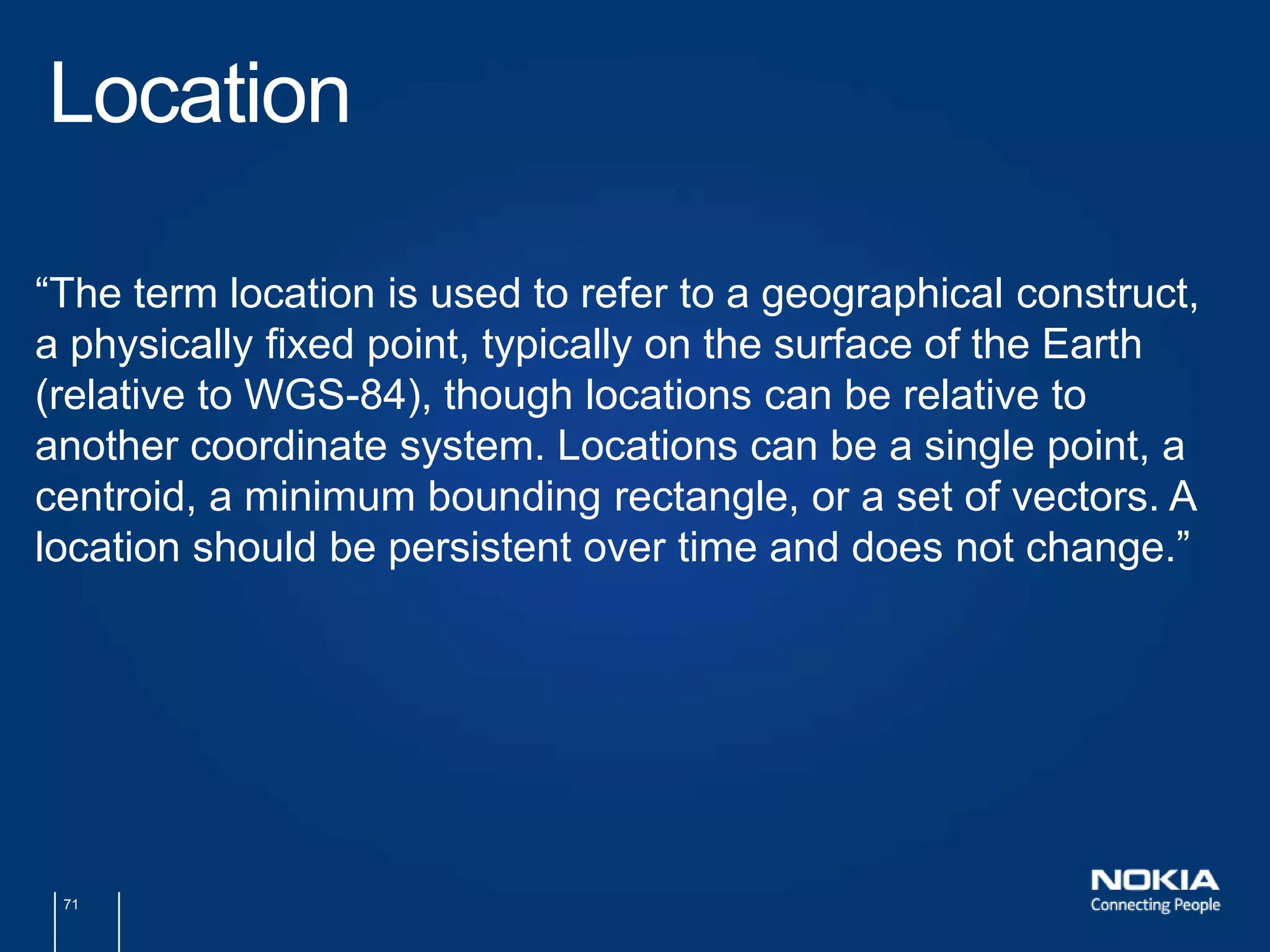
Gary Gale, Director, Places Registrygary.gale@nokia.comtwitter.com/vicchiThe Location Business Summit Europe 2011Amsterdam, May 201152.37273, 4.8944A Sense Of Place1
Gary Gale, Director, Places Registrygary.gale@nokia.comtwitter.com/vicchiWhereCamp EU 2011Berlin, May 201152.536997, 13.408315A Sense Of Place2
About Me …Director, Places Registry, NokiaPreviously Director, Yahoo! Geo TechnologiesBlogger: http://www.vicchi.orgTweeter: http://twitter.com/vicchiTom Coates on Flickr : http://www.flickr.com/photos/plasticbag/4475788424/
William Nicholson on Flickr : http://www.flickr.com/photos/messiaen/2066161937/
5In The BeginningWas The Map
Norman B. Leventhal Map Center at the BPL on Flickr : http://www.flickr.com/photos/normanbleventhalmapcenter/2675672726/
Norman B. Leventhal Map Center at the BPL on Flickr : http://www.flickr.com/photos/normanbleventhalmapcenter/2710792122/
8The MapWasNotUbiquitous
9The MapWasNotDemocratic
Sue Clarke on Flickr : http://www.flickr.com/photos/perpetualplum/4775662240/
Andrew Myers on Flickr : http://www.flickr.com/photos/lifesgreatadventures/491420858/
Howard on Flickr : http://www.flickr.com/photos/innpictime/3094017816/
Sarah Barker on Flickr : http://www.flickr.com/photos/sarahgb/4518082475/
Joe Bennett on Flickr : http://www.flickr.com/photos/jbennett/168171561/
Jaina on Flickr : http://www.flickr.com/photos/pizzagirl/4854457974/
16The MapWasBecomingUbiquitous
quimby on Flickr : http://www.flickr.com/photos/orqwith/4585238744/
18The MapWasStillNotDemocratic
Paul Adams on Flickr : http://www.flickr.com/photos/padday/3213420864/
Martin Phillip on Flickr : http://www.flickr.com/photos/49602327@N04/5472778729/
Ben Smith on Flickr : http://www.flickr.com/photos/ben_smith_uk/4292933460/
24
Ben Smith on Flickr : http://www.flickr.com/photos/ben_smith_uk/4292933460/
J Brew on Flickr : http://www.flickr.com/photos/brewbooks/3648121891/
Alisha Rusher on Flickr : http://www.flickr.com/photos/9541469@N05/2590296050/
Ben Smith on Flickr : http://www.flickr.com/photos/ben_smith_uk/4292933460/
33The Map Is NowUbiquitous
34The Map Is NowDemocratic
HoriaVarlan on Flickr :http://www.flickr.com/photos/horiavarlan/4290549806/
2Tales on Flickr: http://www.flickr.com/photos/stigster/3761714132/
Dennis Hurd on Flickr :http://www.flickr.com/photos/dennissylvesterhurd/4958013228/
terren on Flickr : http://www.flickr.com/photos/8136496@N05/2327243497/
WaleedAlzuhair on Flickr : http://www.flickr.com/photos/waleedalzuhair/2492158122/
40But …
Doc Searles on Flickr : http://www.flickr.com/photos/docsearls/5500714140/
AlexandreDulaunoy on Flickr : http://www.flickr.com/photos/adulau/3011878917/
43It’s Time For An Open Database Of Places“Here is the problem: These efforts at creating an underlying database of places are duplicative, and any competitive advantage any single company gets from being more comprehensive than the rest will be short-lived at best. It is time for an open database of places which all companies and developers can both contribute to and borrow from.  But in order for such a database to be useful, the biggest and fastest-growing Geo companies need to contribute to it.”http://techcrunch.com/2010/04/17/open-database-places/
Aleks on Flickr : http://www.flickr.com/photos/toastkid/5271846584/
Doc Searles on Flickr : http://www.flickr.com/photos/docsearls/5500714140/
WirawatLian-udom on Flickr : http://www.flickr.com/photos/mytudut/5197551003/
47Place
48POI
49Landmark
50Location
Melvin Gaal  on Flickr : http://www.flickr.com/photos/94379417@N00/4808475862/
Joe Forjette on Flickr : http://www.flickr.com/photos/joeforjette/2258604974/
53Place?POI?Landmark?Location?
Anthony Kelly on Flickr : http://www.flickr.com/photos/62337512@N00/3902764265/
55Place?POI?Landmark?Location?
M. H. Stevens on Flickr : http://www.flickr.com/photos/ick9s/2671199350/
57Place?POI?Landmark?Location?
Megan Morris on Flickr : http://www.flickr.com/photos/megangoodchild/3086517327/
59Place?POI?Landmark?Location?
Brian on Flickr : http://www.flickr.com/photos/lincolnian/107200013/
Salmon Of Doubt on Flickr : http://www.flickr.com/photos/salmonofdoubt/60165838/
62Place?POI?Landmark?Location?
63MaybeWeNeed A Standard?
Dave Rutt on Flickr : http://www.flickr.com/photos/rutty/361579360/
Jamie McIntyre on Flickr : http://www.flickr.com/photos/obstreperously/2446025901/
Vit Brunner on Flickr : http://www.flickr.com/photos/tasuki/3503304405/
67http://
Max Froumentin on Flickr : http://www.flickr.com/photos/maxf/112944254/
70PlaceWorking Group?POI Working Group?LandmarkWorking Group?LocationWorking Group?
71Location“The term location is used to refer to a geographical construct, a physically fixed point, typically on the surface of the Earth (relative to WGS-84), though locations can be relative to another coordinate system. Locations can be a single point, a centroid, a minimum bounding rectangle, or a set of vectors. A location should be persistent over time and does not change.”
72Points Of Interest“Unlike the term location, the term POI is a human construct. POIs describe information about locations such as name, category, unique identifier, or civic address.”
73Place“A place is also a human construct which typically has a coarse level of spatial granularity. Places are generally larger scale administrative constructs, either informally or formally defined. Countries, states, counties, districts, neighborhoods and postal codes or telephone area codes are all places. Places are also informally or colloquially defined, such as the Home Counties in the United Kingdom and the Bay Area in the United States.Places have spatial relationships; with parents, children, adjacencies and contained by semantics. Places also have the same attribute set as POIs, although with differing interpretations based on scale; for example, the address of a Place or its URI would refer to the address of the administrative or governing body of the place.A place typically contains multiple POIs and can also be coterminous with a POI. In the former case, a place, such as a city or a neighborhood, will contain multiple POIs. In the latter case, a place and a POI will occupy the same position and extent, such as in the case of Yellowstone National Park, which is both a Place and a POI.”
74
75<?xml version="1.0" encoding="UTF-8"?><pois>	<poi id="StataCenter" xml:lang="en-US" >		<label primary="true" xml:lang="en-US">Stata Center</label>		<label primary="true" xml:lang="es">Stata Centro</label>		<label>Ray and Maria Stata Center</label>		<label>Building 32</label>		<label>Gates Tower</label>		<label>Dreyfoos Tower</label>		<location id="location1">			<point latitude="42.360890561289295" longitude="-71.09139204025269"/>			<point id="mainpoint" latitude="27.174799" longitude="78.042111" altitude="10m"/>			<center latitude="27.174799" longitude="78.042111"/>			<route>				<point order="0" latitude="42.360890561289295" longitude="-71.09139204025269"/>				<point order="1" latitude="42.361176" longitude="-71.09018"/>				<point order="2" latitude="42.36272976137689" longitude="-71.09049081802368"/>				<point order="3" latitude="42.36318955298668" longitude="-71.09677791595459"/>				<point order="4" latitude="42.363617631805496" longitude="-71.10156297683716"/>			</route>			<area>				<point order="0" latitude="42.360890561289295" longitude="-71.09139204025269"/>				<point order="1" latitude="42.361176" longitude="-71.09018"/>				<point order="2" latitude="42.36272976137689" longitude="-71.09049081802368"/>				<point order="3" latitude="42.36318955298668" longitude="-71.09677791595459"/>				<point order="4" latitude="42.363617631805496" longitude="-71.10156297683716"/>				<point order="5" latitude="42.360890561289295" longitude="-71.09139204025269"/>			</area>			<undetermined/>			<relative location-id="mainpoint" distance-from="10m" bearing-to="20" relative-height="10m"/>		</location>		<category scheme="http://www.census.gov/cgi-bin/sssd/naics/naicsrch?search=2007%20NAICS%20Search&code=611310">			<name xml:lang="en-US">Colleges, Universities, and Professional Schools</name>			<association type="child-of" reference="http://www.census.gov/cgi-bin/sssd/naics/naicsrch?search=2007%20NAICS%20Search&code=6113"/>		</category>	</poi></pois>
76http://www.w3.org/2010/POI/documents/Core/core-20110511.html
77public-poiwg@w3.org
Ruby Gold on Flickr : http://www.flickr.com/photos/13606325@N08/2416993706/
svenwerk on Flickr : http://www.flickr.com/photos/svenwerk/858381180/

A Sense Of Place

  • 1.
    Gary Gale, Director,Places Registrygary.gale@nokia.comtwitter.com/vicchiThe Location Business Summit Europe 2011Amsterdam, May 201152.37273, 4.8944A Sense Of Place1
  • 2.
    Gary Gale, Director,Places Registrygary.gale@nokia.comtwitter.com/vicchiWhereCamp EU 2011Berlin, May 201152.536997, 13.408315A Sense Of Place2
  • 3.
    About Me …Director,Places Registry, NokiaPreviously Director, Yahoo! Geo TechnologiesBlogger: http://www.vicchi.orgTweeter: http://twitter.com/vicchiTom Coates on Flickr : http://www.flickr.com/photos/plasticbag/4475788424/
  • 4.
    William Nicholson onFlickr : http://www.flickr.com/photos/messiaen/2066161937/
  • 5.
  • 6.
    Norman B. LeventhalMap Center at the BPL on Flickr : http://www.flickr.com/photos/normanbleventhalmapcenter/2675672726/
  • 7.
    Norman B. LeventhalMap Center at the BPL on Flickr : http://www.flickr.com/photos/normanbleventhalmapcenter/2710792122/
  • 8.
  • 9.
  • 10.
    Sue Clarke onFlickr : http://www.flickr.com/photos/perpetualplum/4775662240/
  • 11.
    Andrew Myers onFlickr : http://www.flickr.com/photos/lifesgreatadventures/491420858/
  • 12.
    Howard on Flickr: http://www.flickr.com/photos/innpictime/3094017816/
  • 13.
    Sarah Barker onFlickr : http://www.flickr.com/photos/sarahgb/4518082475/
  • 14.
    Joe Bennett onFlickr : http://www.flickr.com/photos/jbennett/168171561/
  • 15.
    Jaina on Flickr: http://www.flickr.com/photos/pizzagirl/4854457974/
  • 16.
  • 17.
    quimby on Flickr: http://www.flickr.com/photos/orqwith/4585238744/
  • 18.
  • 19.
    Paul Adams onFlickr : http://www.flickr.com/photos/padday/3213420864/
  • 20.
    Paul Adams onFlickr : http://www.flickr.com/photos/padday/3213420864/
  • 21.
    Paul Adams onFlickr : http://www.flickr.com/photos/padday/3213420864/
  • 22.
    Martin Phillip onFlickr : http://www.flickr.com/photos/49602327@N04/5472778729/
  • 23.
    Ben Smith onFlickr : http://www.flickr.com/photos/ben_smith_uk/4292933460/
  • 24.
  • 25.
    Ben Smith onFlickr : http://www.flickr.com/photos/ben_smith_uk/4292933460/
  • 26.
    J Brew onFlickr : http://www.flickr.com/photos/brewbooks/3648121891/
  • 27.
    Alisha Rusher onFlickr : http://www.flickr.com/photos/9541469@N05/2590296050/
  • 28.
    Ben Smith onFlickr : http://www.flickr.com/photos/ben_smith_uk/4292933460/
  • 29.
    Ben Smith onFlickr : http://www.flickr.com/photos/ben_smith_uk/4292933460/
  • 30.
    Ben Smith onFlickr : http://www.flickr.com/photos/ben_smith_uk/4292933460/
  • 31.
    Ben Smith onFlickr : http://www.flickr.com/photos/ben_smith_uk/4292933460/
  • 32.
    Ben Smith onFlickr : http://www.flickr.com/photos/ben_smith_uk/4292933460/
  • 33.
    33The Map IsNowUbiquitous
  • 34.
    34The Map IsNowDemocratic
  • 35.
    HoriaVarlan on Flickr:http://www.flickr.com/photos/horiavarlan/4290549806/
  • 36.
    2Tales on Flickr:http://www.flickr.com/photos/stigster/3761714132/
  • 37.
    Dennis Hurd onFlickr :http://www.flickr.com/photos/dennissylvesterhurd/4958013228/
  • 38.
    terren on Flickr: http://www.flickr.com/photos/8136496@N05/2327243497/
  • 39.
    WaleedAlzuhair on Flickr: http://www.flickr.com/photos/waleedalzuhair/2492158122/
  • 40.
  • 41.
    Doc Searles onFlickr : http://www.flickr.com/photos/docsearls/5500714140/
  • 42.
    AlexandreDulaunoy on Flickr: http://www.flickr.com/photos/adulau/3011878917/
  • 43.
    43It’s Time ForAn Open Database Of Places“Here is the problem: These efforts at creating an underlying database of places are duplicative, and any competitive advantage any single company gets from being more comprehensive than the rest will be short-lived at best. It is time for an open database of places which all companies and developers can both contribute to and borrow from. But in order for such a database to be useful, the biggest and fastest-growing Geo companies need to contribute to it.”http://techcrunch.com/2010/04/17/open-database-places/
  • 44.
    Aleks on Flickr: http://www.flickr.com/photos/toastkid/5271846584/
  • 45.
    Doc Searles onFlickr : http://www.flickr.com/photos/docsearls/5500714140/
  • 46.
    WirawatLian-udom on Flickr: http://www.flickr.com/photos/mytudut/5197551003/
  • 47.
  • 48.
  • 49.
  • 50.
  • 51.
    Melvin Gaal on Flickr : http://www.flickr.com/photos/94379417@N00/4808475862/
  • 52.
    Joe Forjette onFlickr : http://www.flickr.com/photos/joeforjette/2258604974/
  • 53.
  • 54.
    Anthony Kelly onFlickr : http://www.flickr.com/photos/62337512@N00/3902764265/
  • 55.
  • 56.
    M. H. Stevenson Flickr : http://www.flickr.com/photos/ick9s/2671199350/
  • 57.
  • 58.
    Megan Morris onFlickr : http://www.flickr.com/photos/megangoodchild/3086517327/
  • 59.
  • 60.
    Brian on Flickr: http://www.flickr.com/photos/lincolnian/107200013/
  • 61.
    Salmon Of Doubton Flickr : http://www.flickr.com/photos/salmonofdoubt/60165838/
  • 62.
  • 63.
  • 64.
    Dave Rutt onFlickr : http://www.flickr.com/photos/rutty/361579360/
  • 65.
    Jamie McIntyre onFlickr : http://www.flickr.com/photos/obstreperously/2446025901/
  • 66.
    Vit Brunner onFlickr : http://www.flickr.com/photos/tasuki/3503304405/
  • 67.
  • 68.
    Max Froumentin onFlickr : http://www.flickr.com/photos/maxf/112944254/
  • 70.
    70PlaceWorking Group?POI WorkingGroup?LandmarkWorking Group?LocationWorking Group?
  • 71.
    71Location“The term locationis used to refer to a geographical construct, a physically fixed point, typically on the surface of the Earth (relative to WGS-84), though locations can be relative to another coordinate system. Locations can be a single point, a centroid, a minimum bounding rectangle, or a set of vectors. A location should be persistent over time and does not change.”
  • 72.
    72Points Of Interest“Unlikethe term location, the term POI is a human construct. POIs describe information about locations such as name, category, unique identifier, or civic address.”
  • 73.
    73Place“A place isalso a human construct which typically has a coarse level of spatial granularity. Places are generally larger scale administrative constructs, either informally or formally defined. Countries, states, counties, districts, neighborhoods and postal codes or telephone area codes are all places. Places are also informally or colloquially defined, such as the Home Counties in the United Kingdom and the Bay Area in the United States.Places have spatial relationships; with parents, children, adjacencies and contained by semantics. Places also have the same attribute set as POIs, although with differing interpretations based on scale; for example, the address of a Place or its URI would refer to the address of the administrative or governing body of the place.A place typically contains multiple POIs and can also be coterminous with a POI. In the former case, a place, such as a city or a neighborhood, will contain multiple POIs. In the latter case, a place and a POI will occupy the same position and extent, such as in the case of Yellowstone National Park, which is both a Place and a POI.”
  • 74.
  • 75.
    75<?xml version="1.0" encoding="UTF-8"?><pois> <poiid="StataCenter" xml:lang="en-US" > <label primary="true" xml:lang="en-US">Stata Center</label> <label primary="true" xml:lang="es">Stata Centro</label> <label>Ray and Maria Stata Center</label> <label>Building 32</label> <label>Gates Tower</label> <label>Dreyfoos Tower</label> <location id="location1"> <point latitude="42.360890561289295" longitude="-71.09139204025269"/> <point id="mainpoint" latitude="27.174799" longitude="78.042111" altitude="10m"/> <center latitude="27.174799" longitude="78.042111"/> <route> <point order="0" latitude="42.360890561289295" longitude="-71.09139204025269"/> <point order="1" latitude="42.361176" longitude="-71.09018"/> <point order="2" latitude="42.36272976137689" longitude="-71.09049081802368"/> <point order="3" latitude="42.36318955298668" longitude="-71.09677791595459"/> <point order="4" latitude="42.363617631805496" longitude="-71.10156297683716"/> </route> <area> <point order="0" latitude="42.360890561289295" longitude="-71.09139204025269"/> <point order="1" latitude="42.361176" longitude="-71.09018"/> <point order="2" latitude="42.36272976137689" longitude="-71.09049081802368"/> <point order="3" latitude="42.36318955298668" longitude="-71.09677791595459"/> <point order="4" latitude="42.363617631805496" longitude="-71.10156297683716"/> <point order="5" latitude="42.360890561289295" longitude="-71.09139204025269"/> </area> <undetermined/> <relative location-id="mainpoint" distance-from="10m" bearing-to="20" relative-height="10m"/> </location> <category scheme="http://www.census.gov/cgi-bin/sssd/naics/naicsrch?search=2007%20NAICS%20Search&code=611310"> <name xml:lang="en-US">Colleges, Universities, and Professional Schools</name> <association type="child-of" reference="http://www.census.gov/cgi-bin/sssd/naics/naicsrch?search=2007%20NAICS%20Search&code=6113"/> </category> </poi></pois>
  • 76.
  • 77.
  • 78.
    Ruby Gold onFlickr : http://www.flickr.com/photos/13606325@N08/2416993706/
  • 79.
    svenwerk on Flickr: http://www.flickr.com/photos/svenwerk/858381180/
  • 80.
    Gary Gale, Director,Places Registrygary.gale@nokia.comtwitter.com/vicchiThank You For Listening …80

Editor's Notes

  • #4 Hello, I&apos;m Gary. This is the second year running I&apos;ve been at #locbiz and it&apos;s nice to be back and it&apos;s nice to see so many familiar faces, the &quot;usual suspects of geo&quot; if you will, in the audience.
  • #5 I&apos;ve been working in the location/geo/maps space for quite a few years now and it&apos;s fair to say that I&apos;m a 100% unreconstructed map geek and location nerd. But enough about me ...
  • #6 At least for the purposes of this talk, in the beginning was the map …And the map was not democratic nor was it ubiquitous
  • #7 the map was for the rich, the powerful and the learnedit showed dominion, possession and was reserved for only a lucky fewmaps were, by today&apos;s standards at least inaccurate, incredibly costly and were often commissioned as gifts by the nobility seeking to curry favour with the powerful
  • #8 maps showed ownership, demarcated territory and showed who the commoner owed allegiance or taxes tobut the map was also a work of art, taking hours of labour to create and to adorn
  • #9 compared to today, the map was far from ubiquitous
  • #10 and it was far from democratic
  • #11 Fast forward to the time I was growing up and the map started to be everywhere. I grew up with the map. In almost every class room I was taught in there was a political map of the world, which was often out of date and, at least in the UK, which showed a strong bias towards showing the remnants of the British Empire.
  • #12 Even out of school, I grew up with the map. These were the the 1970&apos;s, where air travel was for the privileged and well to do. So we vacationed in the UK, driving all over the country, guided by a road atlas which would be well thumbed and last about 2 years before falling apart from over-use.
  • #13 Everywhere we went, we bought a map to show us where we were and where to go. As I grew up in the UK, the map was the Ordnance Survey map, for which I still have a strong and special affection.
  • #14 The map collection grew, as I did, taking up more and more space on the bookshelf.
  • #15 If you were luck enough to live in a major metropolitan area you probably went around with a city street atlas such as this one from London with you.
  • #16 I lugged one of these around for the best part of two decades, getting ever more battered and worn and filled with hand written navigation notes on how to get from A to B. Consumer satnav was still in its infancy and was, like early mobile phones, both expensive and confined to an in-car device on luxury and high end car models.
  • #17 The map was becoming ubiquitous
  • #18 But despite the ubiquity, the map was not instantly nor easily accessible, you needed to be taught to read a map, to infer meaning from the special set of symbols that denoted the key features on the map. And as the vast majority of the maps were still printed, there was a limit to the amount of information that could be imparted on a single sheet. There was no facility for enhanced or rich data about the places on the map. There was little if no facility for contributing to the map, unless you were so minded to point out omissions and inaccuracies on the map to the mapping companies and even then, it would take a long period of time to see those changes reflected on the next, printed, edition of the map. Even the in-car solutions were more concerned with getting from A-B and not about providing a rich, place based experience.
  • #19 The map was most definitely still not democratic
  • #20 But then maps made it onto the web like this
  • #21 ... and this
  • #22 And rather than carry around a local street atlas, people started instead to carry round a laser printed copy of the map for where they wanted to go. It was still a physical printed piece of paper, but the data which produced the map had started to go from being updated in traditional publisher&apos;s timescales to being updated in internet timescales.
  • #23 Now fast forward to just a few short years later
  • #24 And those same maps, now with navigation and with a much richer place experience started to appear and people wandering around cities staring at a piece of laser printed paper started to be replaced by people wandering around cities staring at their mobile phones. This new map wasn’t just about roads and street names …
  • #25 … it had navigation, it had places, it had checking in and federating those check-ins to other social networks as well.
  • #26 … and therich, place based information that was being made available on the mobile was available on the web as well
  • #27 And of course, it wasn’t just Nokia that&apos;s doing this!
  • #28 But one lesson that&apos;s been learnt over this time is that in the mapping and mapping data side alone there is and probably never will be one single authoritative source of data.
  • #29 At Nokia, we help people to put data onto the map that we create, with local businesses and merchants claiming their place on the map and providing up to date and informative information
  • #30 Google are doing the same
  • #31 As are Facebook
  • #32 But it&apos;s not just mobile phone, mapping, search engines and social networks enabling their user community to participate in this democratisation of the map. It&apos;s location based, check-in apps
  • #33 As well as companies that are focusing entirely on place data.
  • #34 The map, on the web, on the mobile is now ubiquitous ...
  • #35 And with the web, with the mobile, with all the different ways in which people can contribute and curate the data that appears on the map, that makes the map so much more useful, the map itself is now democratic.
  • #36 But why is all of this map ubiquity and democratisation and all of this place data important?
  • #37 Well firstly as we’ve moved away from a purely navigation view of mobile maps, place matters. It increases relevance and discoverability, because, after all, in the real world, people talk about places much more than they talk about addresses
  • #38 And equally importantly, place is a key source of monetization and revenue opportunities
  • #39 But one lesson that&apos;s been learnt over this time is that in the mapping and mapping data side alone there is and probably never will be one single authoritative source of data.
  • #40 … and we&apos;re nowin an age of masses upon masses of data; maps, place and other location enabled data sets, all of which should work together …
  • #41 But ...
  • #42 All of this data lives in silos. Differing types of categorisation, different types of coordinates, different types of languages, different ways of referring to the same place
  • #43 And as if this wasn&apos;t enough of a barrier to use, there&apos;s a whole slew of differing, well meaning and well intended, licenses which means that a lot of these data sets just can&apos;t be used together.
  • #44 In the Spring of 2010, TechCrunch made a call for an “open database of places” in response to all of these data silos
  • #45 This is well meaning but I think it is ultimately unworkable. As with maps and mapping data so it is with place and place data there is and probably never will be one single authoritative source of data. Some companies will always protect the resources that they have invested in; bigger companies are even more sensitive than smaller ones. Diverse interests need to be served, from small developers to large corporations, from contributors to users.
  • #46 Because even if the dream of an open database of places were to be realised, it would have its own licensing terms, its own categorisation, its own terms of reference. It would be just another silo. Maybe an open silo, but still a silo and thus still subject to the same set of problems that all the other silos face.
  • #47 At Nokia we believe that the best way to solve this problem is not to aggregate these place data sets, but to link them together, providing a mapping between identifiers and API end points and we are creating such a canonical places database that work with the other data silos.But this is only part of the solution. Within the current wealth of data sets a wildly differing set of terms are used to refer to the stuff we&apos;re putting on maps, and I&apos;ve been guilty of this in this talk ...
  • #48 ... by using the term &quot;place&quot;, which is nice succinct way of talking about this sort of data, but other people, myself included, use ...
  • #49 … POI
  • #50 … Landmark
  • #51 ... and sometimes even location to talk about the same thing that’s been placed upon the map
  • #52 ... everyone is talking about place, and location, and POIs and landmarks but it&apos;s extremely challenging to listen to all of this and find a common term of reference. This is the sort of thing I mean …
  • #53 ... the Brandenburg Gate in Berlin, also known as Brandenburger Tor
  • #54 Place? POI? Landmark? Location?
  • #55 ... Big Ben in London
  • #56 Place? POI? Landmark? Location?
  • #57 ... the Old Faithful geyser in Yellowstone National Park
  • #58 Place? POI? Landmark? Location?
  • #59 ... and it&apos;s not just things which can be classed as traditional landmarks or tourist attractions … what about your local convenience store?
  • #60 Place? POI? Landmark? Location?
  • #61 ... and in some data sets, it all gets a little bit crazy, including things such as post boxes ...
  • #62 ... and taking it to another level, street furniture such as lamp posts
  • #63 Place? POI? Landmark? Location? You tell me ...
  • #64 As cross linking the data sets is only half of the solution, maybe the other half is in having a standardised way of referring to places.
  • #65 Now I realise that the mere mention of standards to a lot of developers is enough to induce a certain state of mind. But simple and lightweight standards have their place.
  • #66 We have a standard side of the road that we drive on. Now admittedly not all countries agree on this and if like me you live near a major airport, you soon learn to drive with care and attention around the rental car lots as some people, fresh off a long haul flight, might not always be sure which side of the road they&apos;re supposed to be driving
  • #67 And of course, we all know the standard of &quot;red means stop, green means go&quot; for traffic lights from an early age. So standards definitely have their place, and as in real life, so it is on the web
  • #68 ... because if it wasn&apos;t for the lightweight standard that describes the HTTP protocol there wouldn&apos;t be the web, at least not in the way in which we use it and understand it today ...
  • #69 ... which is a nice way to segue into the role of the W3C in this discussion, because in addition to defining the standards that make today&apos;s internet and web work, the W3C formed a working group, which I am fortunate enough to sit on, to try and formalise the concept of a POI
  • #70 The POI Working group, formed in September of last year, is tasked with &quot;developing a specification for representing Points of Interest, including common properties such as the name, location and shape, while also ensuring extensibility&quot;
  • #71 ... but is it the POI Working Group, or the Place Working Group or any other of the terms that are being used interchangeably? Thankfully, one of the first things the WG worked on was trying to nail down and define these terms ...
  • #72 ... for Location
  • #73 ... for POIs
  • #74 ... and for Place
  • #75 At the highest of levels it looks something like this. This is grossly simplified and doesn&apos;t attempt to show all the possible metadata attributes that a POI can have, nor whether they&apos;re mandatory or optional.
  • #76 Put this all together and you get some XML which looks something like this.
  • #77 I strongly encourage you all to read the draft standard on the W3C web site ...
  • #78 ... and to subscribe to the public mailing list for the WG where all of this and more is debated
  • #79 So to sum up. We have a ubiquitous and democratic map. We have this data exposed on the web, on the mobile device and via APIs. All of this data has much value, but he real value in this data comes, when you understand the many different ways real people and data sources describe the same Place; to interpret those ways of describing Place and make use out of this information.Every company can keep its originally owned data but needs to “store” relationships (such as URLs, linkages and other resources) which can be used to enrich our view of the world.
  • #80 This notion of data linkages, plus all sources of data using a common form of reference framework can, I strongly believe, allow us all to be globally relevant locally, because we live and work in a global marketplace and the internet knows no boundaries. Everywhere is local to someone, wherever in the world you are.Being globally relevant locally is a difficult job, but this is the direction that our industry is moving towards. To succeed, companies need to have a global and local understanding and an ability to manage both.
  • #81 … thank you all for listening