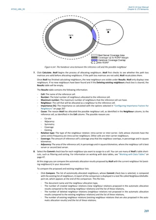
Downloaded 753 times


![164
Atoll 3.1.0 User Manual
Chapter 5: Working with Calculations in Atoll © Forsk 2011
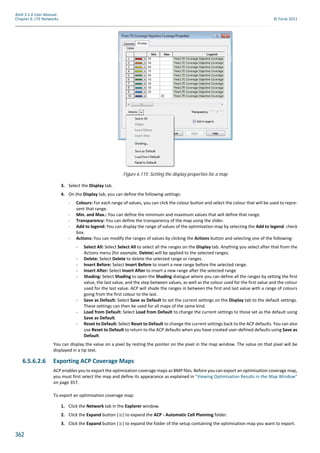
4. Select Properties from the context menu. The Properties dialogue appears.
5. Click the Configuration tab.
6. Under Formulas assigned to clutter classes, select the Default formula row. Under this grid, choose the appropriate
formula in the formula scrolling list.
Atoll uses the default environment formula for calculations on any clutter class to which you have not assigned an
environment formula or if you do not have clutter classes in your Atoll document.
7. For each clutter class under Formulas assigned to clutter classes, select a formula from the list.
8. For each clutter class under Additional Losses per Clutter Class, enter an optional correction (in dB). This correction
acts as an additional loss on the loss calculated by the chosen formula.
For information on modifying the selected formula, see "Creating or Modifying Environment Formulas (Okumura-
Hata)" on page 164.
9. Click OK.
5.1.3.3 Creating or Modifying Environment Formulas (Okumura-Hata)
Several environment formulas are available with the Okumura-Hata propagation model to model different environments. You
can modify existing environment formulas used by the Okumura-Hata propagation model or create new environmental
formulas.
To create or modify an environment formula:
1. Click the Parameters tab of the Explorer window.
2. Click the Expand button ( ) to expand the Propagation Models folder.
3. Right-click Okumura-Hata. The context menu appears.
4. Select Properties from the context menu. The Properties dialogue appears.
5. Click the Configuration tab.
6. Click the Formulas button. The Formulas dialogue appears. You can do the following:
- Add: To create a new formula, click the Add button and modify the parameters of the formula.
- Delete: To delete a formula, select the formula and click the Delete button.
- Modify: To modify an existing formula, select the formula and modify the parameters.
7. Click OK to save your changes and close the Formulas dialogue.
8. Click OK.
5.1.4 The Cost-Hata Propagation Model
The Cost-Hata model is suited for coverage predictions in the 1500 to 2000 MHz band over long distances (from one to 20 km).
It is best suited to DCS 1800 and UMTS radio technologies.
Hata models in general are well adapted to the urban environment. You can define several corrective formulas and associate
a formula with each clutter class to adapt the Hata model to a wide variety of environments. You can also define a default
formula to be used when no land use data is available.
In this section, the following are explained:
• "Defining General Settings (Cost-Hata)" on page 165
• "Selecting an Environment Formula (Cost-Hata)" on page 165
• "Creating or Modifying Environment Formulas (Cost-Hata)" on page 165.
Correction terms can be evaluated using the Automatic Calibration Wizard. For informa-
tion on the Automatic Calibration Wizard, see the Measurements and Model Calibration
Guide.
• You can weight the diffraction loss by setting the diffraction multiplying factor
within the range [0;1].
• Constant values and diffraction multiplying factor can be evaluated using the Auto-
matic Calibration Wizard for each environment formula. For information on the
Automatic Calibration Wizard, see the Measurements and Model Calibration
Guide.](https://image.slidesharecdn.com/95763406-atoll-3-1-0-user-manual-lte-150807145852-lva1-app6892/85/95763406-atoll-3-1-0-user-manual-lte-164-320.jpg)
![166
Atoll 3.1.0 User Manual
Chapter 5: Working with Calculations in Atoll © Forsk 2011
8. Click OK.
5.1.5 The ITU 529-3 Propagation Model
The ITU 529-3 model is suited for predictions in the 300 to 1500 MHz band over long distances (from one to 100 km). It is best
suited to the GSM 900 radio technology.
Hata models in general are well adapted to the urban environment. You can define several corrective formulas and associate
a formula with each clutter class to adapt the Hata model to a wide variety of environments. You can also define a default
formula to be used when no land use data is available. In addition, for long distances 20km<d<100 km), the model uses auto-
matically a corrective formula as defined in the recommendation.
In this section, the following are explained:
• "Defining General Settings (ITU 529-3)" on page 166
• "Selecting an Environment Formula (ITU 529-3)" on page 166
• "Creating or Modifying Environment Formulas (ITU 529-3)" on page 167.
5.1.5.1 Defining General Settings (ITU 529-3)
To set general parameters on the ITU 529-3 propagation model:
1. Click the Parameters tab of the Explorer window.
2. Click the Expand button ( ) to expand the Propagation Models folder.
3. Right-click ITU529. The context menu appears.
4. Select Properties from the context menu. The Properties dialogue appears.
5. Click the Parameters tab. You can modify the following settings:
- Add diffraction loss: The ITU 529-3 propagation model can take into account losses due to diffraction, using a 1-
knife-edge Deygout method, and using the ground altitude given in the DTM. For detailed information on the
Deygout method, see the Technical Reference Guide. The calculations take the curvature of the earth into account.
Select "1 - Yes" if you want the propagation model to add losses due to diffraction.
- Limitation to free space loss: When using a Hata-based propagation model, it is possible to calculate a theoretical
path loss that ends up being lower than the free space loss. In Atoll, you can define any Hata-based propagation
model to never calculate a path loss that is lower than the calculated free space loss per pixel. Select "1 - Yes" if
you want the propagation model to limit the path loss calculated per pixel to the calculated free space loss.
6. Click OK.
5.1.5.2 Selecting an Environment Formula (ITU 529-3)
The ITU 529-3 propagation model can use an environment formula appropriate to each clutter class when calculating. You can
assign a default formula that Atoll can use for all clutter classes for which you have not assigned an environment formula or
if you do not have clutter classes in your Atoll document.
To select environment formulas:
1. Click the Parameters tab of the Explorer window.
2. Click the Expand button ( ) to expand the Propagation Models folder.
3. Right-click ITU529. The context menu appears.
4. Select Properties from the context menu. The Properties dialogue appears.
5. Click the Configuration tab.
6. Under Formulas assigned to clutter classes, select a Default formula.
Atoll uses the default environment formula for calculations on any clutter class to which you have not assigned an
environment formula or if you do not have clutter classes in your Atoll document.
7. For each clutter class under Formulas assigned to clutter classes, select a formula from the list.
• You can weight the diffraction loss by setting the diffraction multiplying factor
within the range [0;1].
• Constant values and diffraction multiplying factor can be evaluated using the Auto-
matic Calibration Wizard for each environment formula. For information on the
Automatic Calibration Wizard, see the Measurements and Model Calibration
Guide.](https://image.slidesharecdn.com/95763406-atoll-3-1-0-user-manual-lte-150807145852-lva1-app6892/85/95763406-atoll-3-1-0-user-manual-lte-166-320.jpg)


![Atoll 3.1.0 User Manual
AT310_UML_E0 Chapter 6: LTE Networks
243
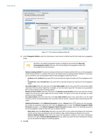
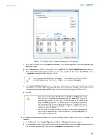
You can save the current report format in a configuration:
a. Under Configuration, click the Save button. The Save As dialogue appears.
b. In the Save As dialogue, browse to the folder where you want to save the configuration and enter a File name.
6. When you have finished defining the format and content of the report, click OK in the Columns to Be Displayed dia-
logue. The coverage prediction report table appears. The report is based on the hot spots and on the focus zone if
available or on the hot spots and computation zone if there is no focus zone.
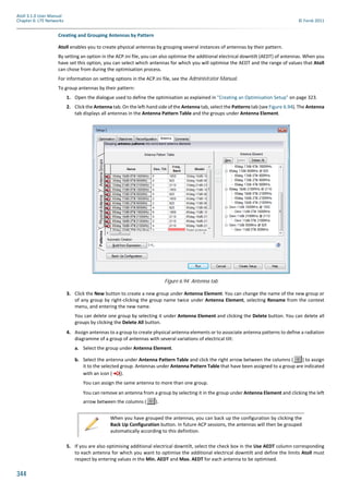
To display a report on all coverage predictions:
1. Click the Network tab of the Explorer window.
2. Right-click the Predictions folder. The context menu appears.
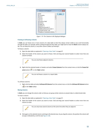
3. Select Generate Report from the context menu. The Columns to Be Displayed dialogue appears.
4. Define the format and content of the report:
You can select the columns that will be displayed in the report and define the order they are in:
a. Select the check box for each column you want to have displayed.
b. Define the order of the columns by selecting each column you want to move and clicking to move it up or
to move it down.
You can save the current report format in a configuration:
a. Under Configuration, click the Save button. The Save As dialogue appears.
b. In the Save As dialogue, browse to the folder where you want to save the configuration and enter a File name.
You can load a configuration that you have saved previously and apply it to the current report:
a. Under Configuration, click the Load button. The Open dialogue appears.
b. Select the configuration you want to load and click Open. The loaded report configuration is applied.
5. When you have finished defining the format and content of the report, click OK in the Columns to Be Displayed dia-
logue. The coverage prediction report table appears. The report shows all displayed coverage predictions in the same
order as in the Predictions folder. The report is based on the focus zone if available or on the calculation zone if there
is no focus zone.
You can include population statistics in the focus zone or hot spots by importing a population map. For information on import-
ing maps, see "Importing a Raster-format Geo Data File" on page 111. Normally, Atoll takes all geo data into consideration,
whether it is displayed or not. However, for the population statistics to be used in a report, the population map has to be
displayed.
To include population statistics in the focus zone or hot spots:
1. Ensure that the population geo data is visible. For information on displaying geo data, see "Displaying or Hiding
Objects on the Map Using the Explorer" on page 18.
2. Click the Network tab in the Explorer window.
3. Right-click the Predictions folder. The context menu appears.
4. Select Generate Report from the context menu. The Columns to Be Displayed dialogue appears.
5. Select the following columns, where "Population" is the name of the folder on the Geo tab containing the population
map:
- "Population" (Population): The number of inhabitants covered.
- "Population" (% Population): The percentage of inhabitants covered.
- "Population" (Population [total]): The total number of inhabitants inside the zone.
6. Click OK.
Atoll saves the names of the columns you select and will automatically select them the next time you create a coverage predic-
tion report.
If you have created a custom data map with integrable data, the data can be used in prediction reports. The data will be
summed over the coverage area for each item in the report (for example, by transmitter or threshold). The data can be value
data (revenue, number of customers, etc.) or density data (revenue/km², number of customer/km², etc.). Data is considered
as non-integrable if the data given is per pixel or polygon and cannot be summed over areas, for example, socio-demographic
classes, rain zones, etc. For information on integrable data in custom data maps, see "Integrable Versus Non Integrable Data"
on page 129.](https://image.slidesharecdn.com/95763406-atoll-3-1-0-user-manual-lte-150807145852-lva1-app6892/85/95763406-atoll-3-1-0-user-manual-lte-243-320.jpg)


This document provides a 3-page user manual summary for Atoll 3.1.0 radio network planning and optimization software. It includes sections on the working environment, explorer window, working with objects, maps, and LTE technology specifications. The manual aims to familiarize users with Atoll's interface and enable efficient use of its features and functions for radio network design.


