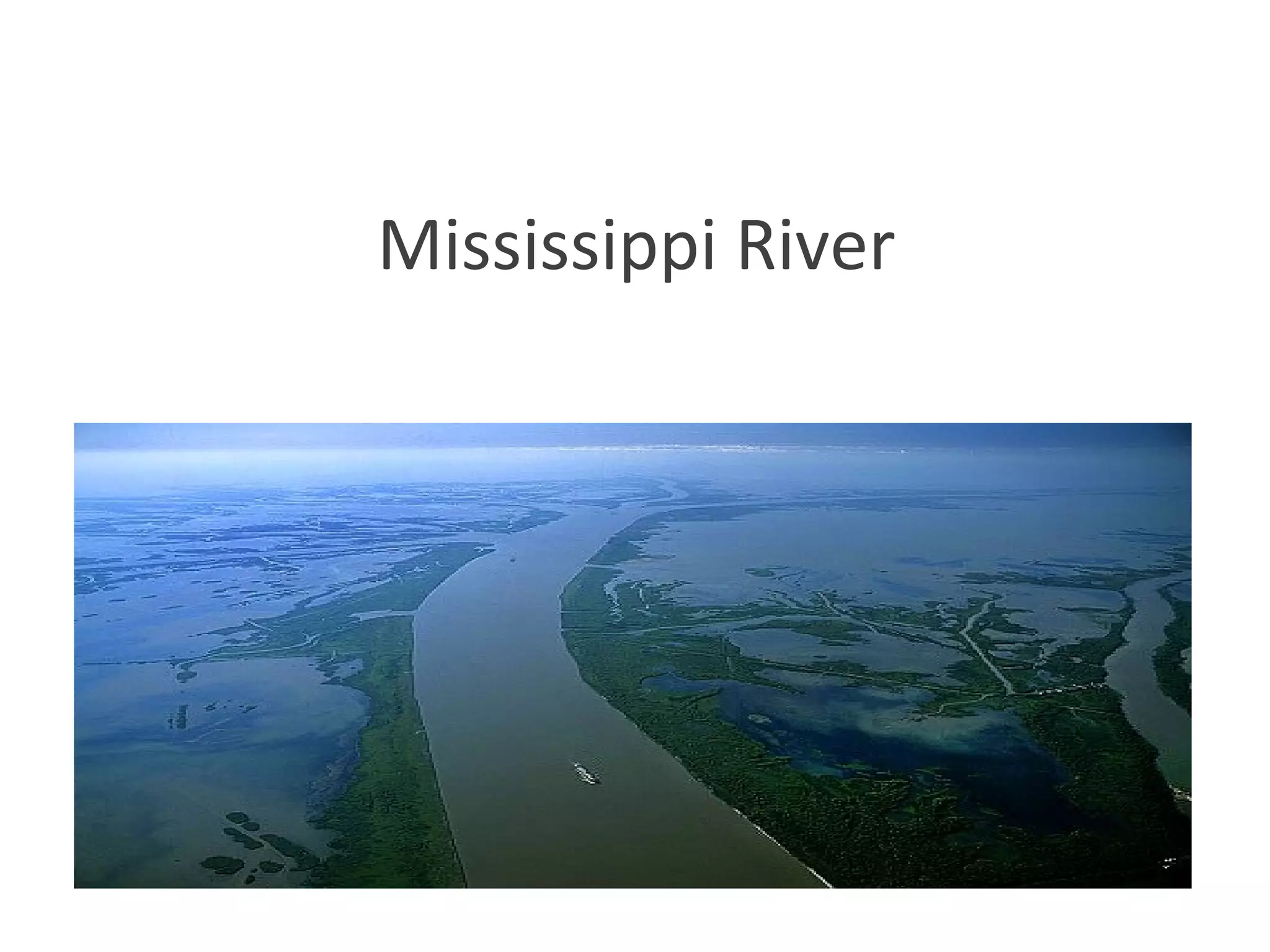
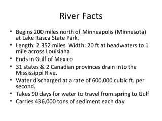
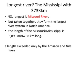
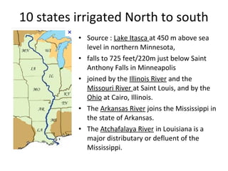
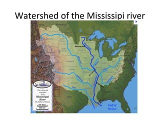
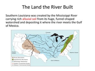
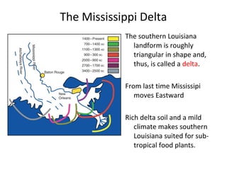
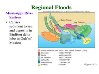
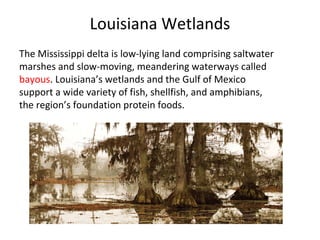
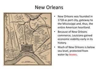
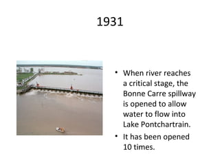
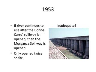
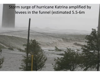
Mississippi River
River Facts
• Begins 200 miles north of Minneapolis (Minnesota)
at Lake Itasca State Park.
• Length: 2,352 miles Width: 20 ft at headwaters to 1
mile across Louisiana
• Ends in Gulf of Mexico
• 31 states & 2 Canadian provinces drain into the
Mississippi Rive.
• Water discharged at a rate of 600,000 cubic ft. per
second.
• Takes 90 days for water to travel from spring to Gulf
• Carries 436,000 tons of sediment each day
Longest river? The Mississipi with
3733km
• NO, longest is Missouri River,
• but taken together, they form the largest
river system in North America.
• the length of the Missouri/Mississippi is
3,895 mi/6268 km long.
a length exceeded only by the Amazon and Nile
rivers
10 states irrigated North to south
• Source : Lake Itasca at 450 m above sea
level in northern Minnesota,
• falls to 725 feet/220m just below Saint
Anthony Falls in Minneapolis
• joined by the Illinois River and the
Missouri River at Saint Louis, and by the
Ohio at Cairo, Illinois.
• The Arkansas River joins the Mississippi in
the state of Arkansas.
• The Atchafalaya River in Louisiana is a
major distributary or defluent of the
Mississippi.
Watershed of the Mississipi river
The Land the River Built
Southern Louisiana was created by the Mississippi River
carrying rich alluvial soil from its huge, funnel-shaped
watershed and depositing it where the river meets the Gulf
of Mexico.
Mississipi: a calamity river or
midwest’s economical infrastructure
• Mark Twain wrote that if the Mississippi were a
"little European river... it would just be a holiday
job... to wall it, and pile it, and dike it, and tame it
down, and boss it around... But this ain't that kind of
a river”
• Still used as a major shipping route for agricultural
products, coal, steel, and petroleum.
• On Mississipi, barges carry
20% of nation’s coal
33% of petroleum
50% of exported grains
Prevention of flooding
US army corps of engineers have attempted to
control flow with dams, locks, and levees
• Levees or floodwall control rising stream level
• Reservoirs on tributary stream store
floodwater for later release
Remember:
the Mississippi River Flood of 1993? It wasn't just the Mississippi
River flooding that wreaked havoc, it was that all those
tributaries flooded as well! At one point, the volume of water
flowing past St. Louis was eleven times the volume of Niagara
Falls!!
The Mississippi Delta
The southern Louisiana
landform is roughly
triangular in shape and,
thus, is called a delta.
From last time Mississipi
moves Eastward
Rich delta soil and a mild
climate makes southern
Louisiana suited for sub-
tropical food plants.
Louisiana Wetlands
The Mississippi delta is low-lying land comprising saltwater
marshes and slow-moving, meandering waterways called
bayous. Louisiana’s wetlands and the Gulf of Mexico
support a wide variety of fish, shellfish, and amphibians,
the region’s foundation protein foods.
New Orleans
• New Orleans was founded in
1718 as port city, gateway to
the Mississippi and, thus, the
entire American heartland.
• Because of New Orleans
commerce, Louisiana gained
economic viability early in its
history.
• Much of New Orleans is below
sea level, protected from
water by levees.
1931
• When river reaches
a critical stage, the
Bonne Carre spillway
is opened to allow
water to flow into
Lake Pontchartrain.
• It has been opened
10 times.
1953
• If river continues to
rise after the Bonne
Carre’ spillway is
opened, then the
Morganza Spillway is
opened.
• Only opened twice
so far.
inadequate?
Storm surge of hurricane Katrina amplified by
levees in the funnel (estimated 5.5-6m
2005 08 29 Hurricane Katrina
• Katrina passes to the east of New Orleans
• Creates 28 foot high storm surge on Mississippi Gulf Coast
• 18 foot high storm surge in Lake Borgne flooding nearly all of the
populated portion of St. Bernard Parish.
• 15 foot storm entering the Industrial Canal through and Lake
Pontchartrain overtops floodwalls, breaches levees on floodwalls on both
sides of the Industrial Canal.
• 11 foot storm surge in Lake Pontchartrain enters 17th St. and London
Avenue drainage canals.
• All levee breaches were on human made for navigation or drainage canals
these levees and floodwalls that had been built by the U.S. Army Corps of
Engineers, some as recently as the mid- 1990s
• Floods over 80% of the city and results in over 1500 deaths
Why New Orleans is Vulnerable To
Hurricanes
Natural Causes
• Location near Gulf of Mexico
• Low elevation (near sea-level)
• Subsidence - caused by compaction of river
deposited sediments
• Erosion of inactive delta lobe
• Sea-level rise due to global warming
Why New Orleans is Vulnerable To
Hurricanes
Human-Related Causes
• Levees on River prevent flooding, but deprive floodplain of sediment,
• Navigation and Exploration Canals which brings water to City
• Salt water get into the fresh water swamps and marshes, killing the fresh-
water vegetation which holds soil
• oil and natural gas are extracted from sediment that once held the oil in
the pore spaces, compacts, resulting in subsidence.
• Nutria are beaver-like animals imported South America 1900, eat marsh
grass and their roots. Without these grasses, storms erode the soil and
turn land into water
• Population expanding into lower lying areas
• Inadequate, poorly designed, & incomplete hurricane protection system
Dont’t forget wildlife in Mississipi
delta
• Endangered species: louisiana black bear, green sea turtle,
• Plants: Cypress trees that we’ve seen
• Fishes, shellfishes
• Migratory Birds: snow gooses, white egrets
• Reptiles: américan alligators that we’ve seen closely
• Today, Coastal Louisiana is losing 24 square miles of
wetlands each year — roughly equivalent to a football field
every 30 minutes!!!
• Dr Amanda Staudt point of view:
https://www.youtube.com/watch?v=tqM4-dHSjSU&feature=player
Infortunatly I haven’t seen
At Home now: delta of the Rhône
• At Home now: delta of the Rhône is divided into two
arms, the Grand Rhône and the Petit Rhône, shortly
before Arles. It forms a delta, the Camargue, and
flowss into the Mediterranean.
•
The Development of the Rhône Valley has been led
by the Compagnie Nationale du Rhône (CNR),
staggered from the 1930s, which included the
construction of dams, pipelines, electric
management program, irrigation, road construction
and industrial equipment
It’s easy
Marseille ou la Nouvelle Orléans
7mn de bonheur bien gagnés…
• https://www.youtube.com/watch?v=wi0cLdJCgTA

2015 05 25 mississipi time memory

  • 1.
  • 2.
    River Facts • Begins200 miles north of Minneapolis (Minnesota) at Lake Itasca State Park. • Length: 2,352 miles Width: 20 ft at headwaters to 1 mile across Louisiana • Ends in Gulf of Mexico • 31 states & 2 Canadian provinces drain into the Mississippi Rive. • Water discharged at a rate of 600,000 cubic ft. per second. • Takes 90 days for water to travel from spring to Gulf • Carries 436,000 tons of sediment each day
  • 3.
    Longest river? TheMississipi with 3733km • NO, longest is Missouri River, • but taken together, they form the largest river system in North America. • the length of the Missouri/Mississippi is 3,895 mi/6268 km long. a length exceeded only by the Amazon and Nile rivers
  • 4.
    10 states irrigatedNorth to south • Source : Lake Itasca at 450 m above sea level in northern Minnesota, • falls to 725 feet/220m just below Saint Anthony Falls in Minneapolis • joined by the Illinois River and the Missouri River at Saint Louis, and by the Ohio at Cairo, Illinois. • The Arkansas River joins the Mississippi in the state of Arkansas. • The Atchafalaya River in Louisiana is a major distributary or defluent of the Mississippi.
  • 5.
    Watershed of theMississipi river
  • 6.
    The Land theRiver Built Southern Louisiana was created by the Mississippi River carrying rich alluvial soil from its huge, funnel-shaped watershed and depositing it where the river meets the Gulf of Mexico.
  • 7.
    Mississipi: a calamityriver or midwest’s economical infrastructure • Mark Twain wrote that if the Mississippi were a "little European river... it would just be a holiday job... to wall it, and pile it, and dike it, and tame it down, and boss it around... But this ain't that kind of a river” • Still used as a major shipping route for agricultural products, coal, steel, and petroleum. • On Mississipi, barges carry 20% of nation’s coal 33% of petroleum 50% of exported grains
  • 8.
    Prevention of flooding USarmy corps of engineers have attempted to control flow with dams, locks, and levees • Levees or floodwall control rising stream level • Reservoirs on tributary stream store floodwater for later release Remember: the Mississippi River Flood of 1993? It wasn't just the Mississippi River flooding that wreaked havoc, it was that all those tributaries flooded as well! At one point, the volume of water flowing past St. Louis was eleven times the volume of Niagara Falls!!
  • 9.
    The Mississippi Delta Thesouthern Louisiana landform is roughly triangular in shape and, thus, is called a delta. From last time Mississipi moves Eastward Rich delta soil and a mild climate makes southern Louisiana suited for sub- tropical food plants.
  • 11.
    Louisiana Wetlands The Mississippidelta is low-lying land comprising saltwater marshes and slow-moving, meandering waterways called bayous. Louisiana’s wetlands and the Gulf of Mexico support a wide variety of fish, shellfish, and amphibians, the region’s foundation protein foods.
  • 12.
    New Orleans • NewOrleans was founded in 1718 as port city, gateway to the Mississippi and, thus, the entire American heartland. • Because of New Orleans commerce, Louisiana gained economic viability early in its history. • Much of New Orleans is below sea level, protected from water by levees.
  • 13.
    1931 • When riverreaches a critical stage, the Bonne Carre spillway is opened to allow water to flow into Lake Pontchartrain. • It has been opened 10 times.
  • 14.
    1953 • If rivercontinues to rise after the Bonne Carre’ spillway is opened, then the Morganza Spillway is opened. • Only opened twice so far. inadequate?
  • 15.
    Storm surge ofhurricane Katrina amplified by levees in the funnel (estimated 5.5-6m
  • 16.
    2005 08 29Hurricane Katrina • Katrina passes to the east of New Orleans • Creates 28 foot high storm surge on Mississippi Gulf Coast • 18 foot high storm surge in Lake Borgne flooding nearly all of the populated portion of St. Bernard Parish. • 15 foot storm entering the Industrial Canal through and Lake Pontchartrain overtops floodwalls, breaches levees on floodwalls on both sides of the Industrial Canal. • 11 foot storm surge in Lake Pontchartrain enters 17th St. and London Avenue drainage canals. • All levee breaches were on human made for navigation or drainage canals these levees and floodwalls that had been built by the U.S. Army Corps of Engineers, some as recently as the mid- 1990s • Floods over 80% of the city and results in over 1500 deaths
  • 18.
    Why New Orleansis Vulnerable To Hurricanes Natural Causes • Location near Gulf of Mexico • Low elevation (near sea-level) • Subsidence - caused by compaction of river deposited sediments • Erosion of inactive delta lobe • Sea-level rise due to global warming
  • 19.
    Why New Orleansis Vulnerable To Hurricanes Human-Related Causes • Levees on River prevent flooding, but deprive floodplain of sediment, • Navigation and Exploration Canals which brings water to City • Salt water get into the fresh water swamps and marshes, killing the fresh- water vegetation which holds soil • oil and natural gas are extracted from sediment that once held the oil in the pore spaces, compacts, resulting in subsidence. • Nutria are beaver-like animals imported South America 1900, eat marsh grass and their roots. Without these grasses, storms erode the soil and turn land into water • Population expanding into lower lying areas • Inadequate, poorly designed, & incomplete hurricane protection system
  • 20.
    Dont’t forget wildlifein Mississipi delta • Endangered species: louisiana black bear, green sea turtle, • Plants: Cypress trees that we’ve seen • Fishes, shellfishes • Migratory Birds: snow gooses, white egrets • Reptiles: américan alligators that we’ve seen closely • Today, Coastal Louisiana is losing 24 square miles of wetlands each year — roughly equivalent to a football field every 30 minutes!!! • Dr Amanda Staudt point of view: https://www.youtube.com/watch?v=tqM4-dHSjSU&feature=player
  • 21.
  • 22.
    At Home now:delta of the Rhône • At Home now: delta of the Rhône is divided into two arms, the Grand Rhône and the Petit Rhône, shortly before Arles. It forms a delta, the Camargue, and flowss into the Mediterranean. • The Development of the Rhône Valley has been led by the Compagnie Nationale du Rhône (CNR), staggered from the 1930s, which included the construction of dams, pipelines, electric management program, irrigation, road construction and industrial equipment
  • 23.
  • 24.
    Marseille ou laNouvelle Orléans
  • 25.
    7mn de bonheurbien gagnés… • https://www.youtube.com/watch?v=wi0cLdJCgTA

Editor's Notes

  • #7 alluvial soil - a fine-grained fertile soil deposited by water flowing over flood plains or in river beds