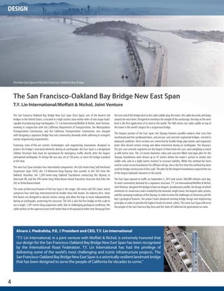
Salvador Herrera, Deputy Director of EMBARQ Mexico, presented on the role of Mexico City's Metrobús bus rapid transit (BRT) system in integrating transport systems and fostering connections within the city. Presentation from EMBARQ Turkey's Livable Cities Symposium, November 20, 2013.
Padma Multipurpose Bridge Project ,the bridge of Bangladesh.It is one of the largest bridge in the world .For implementation this project a group of renowned specialists engineer work together.it is the most challenging infrastructure in the world .This is the bridge that is pride of Bangladesh.
Padma Bridge is one of the most challenging projects in the world. We are constructing the Bridge on the second largest river flow in the world. Every second, approximately 140,000 cubic metre water flows through the project area. Twenty second flowing of that amount will be sufficient to meet one day drinking water demand of Dhaka city. Another challenge is scour depth. We have also considered earthquake related dangers. That's why we are using the second most powerful pile hammer in the world for this project.
River training is another challenge. It requires huge amount of money. Last year there was serious river erosion in the Mawa area, and as a consequence we had to change our design to cope with such types of calamities. It might take more than three years to complete the river training works.
Guidelines for Planning and Construction of Roads in cyclone Prone AreasPhani Mohan K
National Disaster Management Authority approached CSIR- CRRI to prepare the ‘Guidelines for Planning and Construction of Roads in Cyclone Prone Areas’.
This task was jointly undertaken by a team from Geotechnical Engg Division and Bridges and Structures Division of CSIR-CRRI.
The agenda/presentation slide deck shown during the November 3, 2021 Citizens' Transportation Advisory Committee (CTAC) virtual workshop. The workshop video can be viewed at https://youtu.be/dcT7vz80fhE
The agenda/presentation slide deck shown during the July 14, 2021 Freight Transportation Advisory Committee (FTAC) virtual workshop. The workshop video can be viewed at https://youtu.be/zqV-LYyIICk
The agenda/presentation slide deck shown during the May 11, 2021 Bicycle Pedestrian Advisory Committee (BPAC) virtual workshop. The workshop video can be viewed at https://youtu.be/lzCVjfTXmYI
This presentation is a visual demonstration of my
experience.
It contains photographs of some of the exciting projects
I have had the privilege of being involved in and details
of some of the employers I have had the pleasure to
work for.
En este número: Carne aviar: unión, estrategia y éxito – Ariel Esteban Schale – Elvio Baldinelli – Automec – Procórdoba – Financiamiento para exportaciones – Cámara de Comercio Argentino Árabe – Fundación Standard Bank – Régimen de Exportador Confiable – Informe especial Entre Ríos segunda parte - Ferias – Eventos – Calendario 2011.
La revista de la Fundación Exportar reúne notas de interés sobre representantes nacionales, sus talentos exportadores e información destacada de empresas argentinas que han internacionalizado sus productos y servicios.
Efectos Magnetovolúmico y Magnetocalórico en el compuesto Nd2Fe17Universidad de Oviedo
Presentación del trabajo de investigación sobre la interacción entre las anomalías de magnetovolumen y el efecto magnetocalórico en el compuesto intermetálico Nd2Fe17
Proposal to reclaim Chicago's lakefront from the highway using immersed tunnelsJames Chuck
My exploration (and proposal) of how to improve Chicago's North Lake Shore Drive as a multi-modal transportation facility and reclaim the shoreline for the City and its Citizens.
A thoughtful and sustainable strategy to give urban shores and coasts a second chance
Investigation on Bridges Connection to Network Carrefour in Existing Roads in...IJERA Editor
The rapid and continuous growth of populations and vehicles has caused very big traffic volume in most of
African big cities. In order to ensure a better distribution of traffic and enables quick access to vehicles,
reasonable interchange can be designed to allow greater connection and realizes rapid dividing of vehicles at
existing road network carrefour. This paper uses Cotonou, which is the largest urban and economic city of Benin
Republic as a case study. Firstly, the paper reviews literatures on history and development of interchanges bridge
systems. Based on the case study, the paper then mainly introduces a typical interchange at Godomey carrefour,
explains difficulties encountered in engineering design and realizes rapid dividing of vehicles by designing
reasonable interchange at Godomey carrefour, so as to accumulate certain experience in the construction of
interchange at existing road network carrefour. By studying this case, the research seeks to identify and expand
on lessons learned under the first interchange bridge design in Benin. Using the lessons learned government
agencies, engineering and construction communities could adopt reasonable structure and construction method
according to local conditions based on current situations.
Foundation Design For the abutment and footing design, soil anal.docxbudbarber38650
Foundation Design
For the abutment and footing design, soil analysis was required to determine allowable design loads. Our geotechnical engineers have provided a thoroughly soil reports and calculations for the abutment and is located in Appendix XX. With our design constraints, our structural engineers have come to concluded that spread footing design is best for our pedestrian bridge.
Design Criteria
Based on the geotechnical reports, our structural engineers have designed our abutment and footing to transfer the loads from the pedestrian bridge to the underlying soil and to prevent the soil from tipping the abutment over. Our structural team have worked closely with our geotechnical team to design an abutment that capable to support a 144 Kips (Dead + Live) loads coming from the bridge, and to not exceed the bearing capacity of 4000 psf. With the vertical depth of the abutment and footing of 26 ft, our teams already take into consideration that our footing need to be 3 ft below the channel to prevent the soil erosion below the footing. Our abutment and footing will be design for overturning moment and shear coming from soil pushing into the abutment wall. All stresses have been accounted for and designed to be able to handle the above mentioned stresses, all calculations are included in Appendix XX. Both abutment and footing are the same on both end span of the bridge.
Our structural engineers will use 4000 psi concrete, and 60000 psi steel for the abutment and footing design. The abutment dimensions will be 15 ft wide by 24 ft height and thickness of 4 ft. The footing will have dimensions of 15 ft wide by 2 ft depth a thickness of 12 ft.
With the dimensions of abutment and footing calculated, the righting moment created by reinforced concrete is much larger than the overturning moment pushing against it and is adequate for the bridge support.
Table of Contents
1. Executive Summary
2. Project Personnel
3. Preliminary Design Analysis
4. Appendices
a. Overall Plans and Exhibits
b. Traffic Study
c. Geotechnical Evaluation
d. Site – Civil & Utilities
e. Structural Calculations
f. Construction
g. Summary of Assumptions
MFilanc_FIL
Note
MFilanc_FIL
Text Box
The table of contents should be broken down more. For example: 1.1. Introduction
1.2. Background of project
1.3. purpose and Objective
Each one should also list which page and the entire report should have pagination.
Executive Summary
Introduction
Donovan & Associates looks forward to providing professional engineering services to
the City of Escondido for the design and construction of the new Escondido Pure Water
Pipeline.
Donovan & Associates prides itself in offering the most cost-effective and sustainable
solutions for
public infrastructure improvements and land development. The new Escondido Pure
Water Pipeline will be located on Washington Avenue and Spruce Street in the City of
Escondido. This
project will include the evaluati.
Interim Shuttle Association Service Project Project.docxnormanibarber20063
Interim Shuttle Association Service Project
Project Plan
Interim Shuttle Association (ISA)
Contents
6Company Mission Statement
6Company Objectives
6Executive Summary
7Project Purpose/Justification
7Business Need/Case
7In the Autumn of 2012, the Main Way Viaduct Replacement Project will commence. What is the Main Way Viaduct Project?
9Business Objectives
9Project Description
9Project Objectives and Success Criteria
10Requirements
10Constraints
10Assumptions
11Preliminary Scope Statement
11Identify Stakeholders
11Risks
12Project Deliverables
13Summary Milestone Schedule
14Summary Budget
14Project Approval Requirements
15Project Manager
15Identify Stakeholders
15Key Stakeholders
16Stakeholder Analysis
17Shareholder Management Matrix
20Stakeholder Analysis
21Interest / Power Plot
21Attitude / Activity Plot
22Communications Management Approach
22Roles
22Project Sponsor
22Program Manager
22Key Stakeholders
22Change Control Board
23Customer
23Project Manager
23Project Team
23Steering Committee
23Technical Lead
24Project Team Directory
27Issues Management
27Perform Issue Management
26Guidelines for Meetings
26Meeting Agenda
26Meeting Minutes
26Action Items
26Meeting Chair Person
26Note Taker
26Time Keeper
26Parking Lot
28Change Request Form
28Requirements Prioritization Process
29Requirements Prioritization Process
29Product Metrics
30Requirements Management Approach
30Requirements Traceability Matrix
31Business Need
32Product Scope Description
32Mechanical Specifications:
32Strategic Plan
33Schedule/Work Breakdown Schedule
33Outline View
34Hierarchical Structure
35Tabular View
36WBS Dictionary
38Procurement Management Approach
38Procurement Definition
40Type of Contract to be Used
40Contract Approval Process
41Decision Criteria
41Vendor Management
42Performance Metrics for Procurement Activities
42Quality Management Approach
43Quality Requirements / Standards
43Product Quality:
43Process Quality:
44Quality Assurance
44Quality Control
44DUKW Specifications
45Quality Control Measurements
47Risk Introduction
48Top Three Risks
48Risk Management Approach
49Risk Identification
49Risk Qualification and Prioritization
50Risk Monitoring
50Risk Mitigation and Avoidance
51Risk Register
51Change Management Approach
51Definitions of Change
52Roles and Responsibilities
53Change Control Process
54Approvals
55References
57Appendix
58List of Tables and Figures & Exhibits
59Glossary of Communication Technology – Common Acronyms
Project Charter
Company Mission Statement
To provide an affordable, accessible and alternative mode of Transportation (using the DUKWs) to the residents of the Fuqua Sound corridor for the duration of The Main Way Viaduct Replacement Project.
Company Objectives
· We will provide a Shuttle Association service to Everlytown, Kirkwood and Smithville on or before the viaduct officially closes to vehicle traffic in the Fall 2012.
· We will provide service via the waterways until the Bored Tunnel project concludes sometime in 2017.
.
Bridging over river Bhagirathi- a Handbook cum Coffee Table Book by Rajesh Pr...Rajesh Prasad
This is a Handbook cum Coffee Table Book on Bridging over River Bhagirathi (alias Ganges)- Concept to Completion by Rajesh Prasad, Executive Director, Rail Vikas Nigam Ltd (RVNL) depicting from the concept to completion of the Railway Bridge including cantilever launching of the open web girders with span size of 103 m.
Transportation Term PaperDiverging Diamond Interch.docxturveycharlyn
Transportation
Term Paper
Diverging Diamond Interchanges
Table of Contents
Abstract Page 3
Introduction Page 3
Current Interchanges Page 3
Diverging Diamond Interchange Page 4
Traffic Studies Page 5
Future Development Page 6
Conclusion Page 6
References Page 7
Abstract
Introduction
Traffic, we all have experienced the headaches it brings. At an intersection is where the potential conflict is most likely to occur, especially between two major traffic arteries. The goal of traffic engineering is to provide the most efficient means of alleviating the traffic conflicts. However, in areas with increasing traffic demands that the traditional methods have been insufficient in dealing with the higher traffic. Therefore a new intersection design was developed known as the diverging diamond interchange. The diverging diamond interchange utilizes channelization and a crisscross lane pattern to reduce traffic conflict points. Studies have shown that commuters using a diverging diamond interchange feel safer than they do using traditional interchanges. Along with being safer, the diverging diamond interchange is more cost effective than alternative interchanges by utilizing existing infrastructure for its design.
Current Interchanges
Interchanges are a specific classification of intersections which are constructed to provide un-interrupted flow for crossing traffic by changing the elevation between the roadways. Due to this, ramps are required to connect the crossing traffic and allow turning from one to the other. In the usual interchange traffic wanting to turn left has to cross oncoming traffic to enter or exit a ramp perpendicular to vehicle’s current direction. Therefore a left turning vehicle is at a greater risk getting involved in a serious collision when crossing oncoming traffic that may result in fatalities then the through or right turning traffic. Majority of the fatal crashes at an interchange occur from the unprotected left turn.
There are measures of left turn protection with minimal altercations to the design of the intersection. Designing an intersection with left turn protection adds additional cycles to the traffic signal providing more green time for left turning traffic and prevents oncoming traffic from moving. Also, when necessary, extra left turn lanes may be required storage isolating the through traffic. However, a longer cycle length due to left turn protection causes its own problems, in high traffic interchanges. This is because there is longer red time for traffic in other directions when the left turn cycles are added to at an intersection.
Furthermore, when there is too great of a demand for any particular interchange another issue arises, traffic can become backed up causing a delay even after adjusting the signal timing. Traffic backed up at one intersection far enough will affect the traffic flow at other intersection ...
سیستم Roadroid
رودروید سیستمی برای بررسی شرایط راه بر پایه
موبایل می باشد .
سیستم شامل:
)0 برنامه ای برای اندازه گیری ناهمواری راه با
استفاده از لرزه نگار و شتاب سنج تلفن همراه
است.
)2 برنامه ای دیگر برای دسته بندی شرایط راه, جمع
اوری داذه های شانه راه, زهکشی و غیره و
پارامتر iRAP در طول مسیر است.
)3 یک سرویس اینترنتی برای بررسی شرایط راه و
انتقال ان به قسمت نگهداری راه است.
Updates from our new clients since last time, Fulton Hogan New Zeeland, Finnoc at Papua New Guinea. And updated of Swedish Projects and the road inventory app, Enjoy!
Parte de la información sobre el sistema de Roadroid para recoger datos de rugosidad de las carreteras (IRI) utilizando un teléfono inteligente - y proyectos de referencia que estamos haciendo.
GraphSummit Singapore | The Future of Agility: Supercharging Digital Transfor...Neo4j
Leonard Jayamohan, Partner & Generative AI Lead, Deloitte
This keynote will reveal how Deloitte leverages Neo4j’s graph power for groundbreaking digital twin solutions, achieving a staggering 100x performance boost. Discover the essential role knowledge graphs play in successful generative AI implementations. Plus, get an exclusive look at an innovative Neo4j + Generative AI solution Deloitte is developing in-house.
Sudheer Mechineni, Head of Application Frameworks, Standard Chartered Bank
Discover how Standard Chartered Bank harnessed the power of Neo4j to transform complex data access challenges into a dynamic, scalable graph database solution. This keynote will cover their journey from initial adoption to deploying a fully automated, enterprise-grade causal cluster, highlighting key strategies for modelling organisational changes and ensuring robust disaster recovery. Learn how these innovations have not only enhanced Standard Chartered Bank’s data infrastructure but also positioned them as pioneers in the banking sector’s adoption of graph technology.
Goodbye Windows 11: Make Way for Nitrux Linux 3.5.0!SOFTTECHHUB
As the digital landscape continually evolves, operating systems play a critical role in shaping user experiences and productivity. The launch of Nitrux Linux 3.5.0 marks a significant milestone, offering a robust alternative to traditional systems such as Windows 11. This article delves into the essence of Nitrux Linux 3.5.0, exploring its unique features, advantages, and how it stands as a compelling choice for both casual users and tech enthusiasts.
UiPath Test Automation using UiPath Test Suite series, part 6DianaGray10
Welcome to UiPath Test Automation using UiPath Test Suite series part 6. In this session, we will cover Test Automation with generative AI and Open AI.
UiPath Test Automation with generative AI and Open AI webinar offers an in-depth exploration of leveraging cutting-edge technologies for test automation within the UiPath platform. Attendees will delve into the integration of generative AI, a test automation solution, with Open AI advanced natural language processing capabilities.
Throughout the session, participants will discover how this synergy empowers testers to automate repetitive tasks, enhance testing accuracy, and expedite the software testing life cycle. Topics covered include the seamless integration process, practical use cases, and the benefits of harnessing AI-driven automation for UiPath testing initiatives. By attending this webinar, testers, and automation professionals can gain valuable insights into harnessing the power of AI to optimize their test automation workflows within the UiPath ecosystem, ultimately driving efficiency and quality in software development processes.
What will you get from this session?
1. Insights into integrating generative AI.
2. Understanding how this integration enhances test automation within the UiPath platform
3. Practical demonstrations
4. Exploration of real-world use cases illustrating the benefits of AI-driven test automation for UiPath
Topics covered:
What is generative AI
Test Automation with generative AI and Open AI.
UiPath integration with generative AI
Speaker:
Deepak Rai, Automation Practice Lead, Boundaryless Group and UiPath MVP
Generative AI Deep Dive: Advancing from Proof of Concept to ProductionAggregage
Join Maher Hanafi, VP of Engineering at Betterworks, in this new session where he'll share a practical framework to transform Gen AI prototypes into impactful products! He'll delve into the complexities of data collection and management, model selection and optimization, and ensuring security, scalability, and responsible use.
LF Energy Webinar: Electrical Grid Modelling and Simulation Through PowSyBl -...DanBrown980551
Do you want to learn how to model and simulate an electrical network from scratch in under an hour?
Then welcome to this PowSyBl workshop, hosted by Rte, the French Transmission System Operator (TSO)!
During the webinar, you will discover the PowSyBl ecosystem as well as handle and study an electrical network through an interactive Python notebook.
PowSyBl is an open source project hosted by LF Energy, which offers a comprehensive set of features for electrical grid modelling and simulation. Among other advanced features, PowSyBl provides:
- A fully editable and extendable library for grid component modelling;
- Visualization tools to display your network;
- Grid simulation tools, such as power flows, security analyses (with or without remedial actions) and sensitivity analyses;
The framework is mostly written in Java, with a Python binding so that Python developers can access PowSyBl functionalities as well.
What you will learn during the webinar:
- For beginners: discover PowSyBl's functionalities through a quick general presentation and the notebook, without needing any expert coding skills;
- For advanced developers: master the skills to efficiently apply PowSyBl functionalities to your real-world scenarios.
UiPath Test Automation using UiPath Test Suite series, part 5DianaGray10
Welcome to UiPath Test Automation using UiPath Test Suite series part 5. In this session, we will cover CI/CD with devops.
Topics covered:
CI/CD with in UiPath
End-to-end overview of CI/CD pipeline with Azure devops
Speaker:
Lyndsey Byblow, Test Suite Sales Engineer @ UiPath, Inc.
Threats to mobile devices are more prevalent and increasing in scope and complexity. Users of mobile devices desire to take full advantage of the features
available on those devices, but many of the features provide convenience and capability but sacrifice security. This best practices guide outlines steps the users can take to better protect personal devices and information.
In the rapidly evolving landscape of technologies, XML continues to play a vital role in structuring, storing, and transporting data across diverse systems. The recent advancements in artificial intelligence (AI) present new methodologies for enhancing XML development workflows, introducing efficiency, automation, and intelligent capabilities. This presentation will outline the scope and perspective of utilizing AI in XML development. The potential benefits and the possible pitfalls will be highlighted, providing a balanced view of the subject.
We will explore the capabilities of AI in understanding XML markup languages and autonomously creating structured XML content. Additionally, we will examine the capacity of AI to enrich plain text with appropriate XML markup. Practical examples and methodological guidelines will be provided to elucidate how AI can be effectively prompted to interpret and generate accurate XML markup.
Further emphasis will be placed on the role of AI in developing XSLT, or schemas such as XSD and Schematron. We will address the techniques and strategies adopted to create prompts for generating code, explaining code, or refactoring the code, and the results achieved.
The discussion will extend to how AI can be used to transform XML content. In particular, the focus will be on the use of AI XPath extension functions in XSLT, Schematron, Schematron Quick Fixes, or for XML content refactoring.
The presentation aims to deliver a comprehensive overview of AI usage in XML development, providing attendees with the necessary knowledge to make informed decisions. Whether you’re at the early stages of adopting AI or considering integrating it in advanced XML development, this presentation will cover all levels of expertise.
By highlighting the potential advantages and challenges of integrating AI with XML development tools and languages, the presentation seeks to inspire thoughtful conversation around the future of XML development. We’ll not only delve into the technical aspects of AI-powered XML development but also discuss practical implications and possible future directions.
Enchancing adoption of Open Source Libraries. A case study on Albumentations.AIVladimir Iglovikov, Ph.D.
Presented by Vladimir Iglovikov:
- https://www.linkedin.com/in/iglovikov/
- https://x.com/viglovikov
- https://www.instagram.com/ternaus/
This presentation delves into the journey of Albumentations.ai, a highly successful open-source library for data augmentation.
Created out of a necessity for superior performance in Kaggle competitions, Albumentations has grown to become a widely used tool among data scientists and machine learning practitioners.
This case study covers various aspects, including:
People: The contributors and community that have supported Albumentations.
Metrics: The success indicators such as downloads, daily active users, GitHub stars, and financial contributions.
Challenges: The hurdles in monetizing open-source projects and measuring user engagement.
Development Practices: Best practices for creating, maintaining, and scaling open-source libraries, including code hygiene, CI/CD, and fast iteration.
Community Building: Strategies for making adoption easy, iterating quickly, and fostering a vibrant, engaged community.
Marketing: Both online and offline marketing tactics, focusing on real, impactful interactions and collaborations.
Mental Health: Maintaining balance and not feeling pressured by user demands.
Key insights include the importance of automation, making the adoption process seamless, and leveraging offline interactions for marketing. The presentation also emphasizes the need for continuous small improvements and building a friendly, inclusive community that contributes to the project's growth.
Vladimir Iglovikov brings his extensive experience as a Kaggle Grandmaster, ex-Staff ML Engineer at Lyft, sharing valuable lessons and practical advice for anyone looking to enhance the adoption of their open-source projects.
Explore more about Albumentations and join the community at:
GitHub: https://github.com/albumentations-team/albumentations
Website: https://albumentations.ai/
LinkedIn: https://www.linkedin.com/company/100504475
Twitter: https://x.com/albumentations
DevOps and Testing slides at DASA ConnectKari Kakkonen
My and Rik Marselis slides at 30.5.2024 DASA Connect conference. We discuss about what is testing, then what is agile testing and finally what is Testing in DevOps. Finally we had lovely workshop with the participants trying to find out different ways to think about quality and testing in different parts of the DevOps infinity loop.
A tale of scale & speed: How the US Navy is enabling software delivery from l...sonjaschweigert1
Rapid and secure feature delivery is a goal across every application team and every branch of the DoD. The Navy’s DevSecOps platform, Party Barge, has achieved:
- Reduction in onboarding time from 5 weeks to 1 day
- Improved developer experience and productivity through actionable findings and reduction of false positives
- Maintenance of superior security standards and inherent policy enforcement with Authorization to Operate (ATO)
Development teams can ship efficiently and ensure applications are cyber ready for Navy Authorizing Officials (AOs). In this webinar, Sigma Defense and Anchore will give attendees a look behind the scenes and demo secure pipeline automation and security artifacts that speed up application ATO and time to production.
We will cover:
- How to remove silos in DevSecOps
- How to build efficient development pipeline roles and component templates
- How to deliver security artifacts that matter for ATO’s (SBOMs, vulnerability reports, and policy evidence)
- How to streamline operations with automated policy checks on container images
Encryption in Microsoft 365 - ExpertsLive Netherlands 2024Albert Hoitingh
In this session I delve into the encryption technology used in Microsoft 365 and Microsoft Purview. Including the concepts of Customer Key and Double Key Encryption.
Pushing the limits of ePRTC: 100ns holdover for 100 daysAdtran
At WSTS 2024, Alon Stern explored the topic of parametric holdover and explained how recent research findings can be implemented in real-world PNT networks to achieve 100 nanoseconds of accuracy for up to 100 days.
Essentials of Automations: The Art of Triggers and Actions in FMESafe Software
In this second installment of our Essentials of Automations webinar series, we’ll explore the landscape of triggers and actions, guiding you through the nuances of authoring and adapting workspaces for seamless automations. Gain an understanding of the full spectrum of triggers and actions available in FME, empowering you to enhance your workspaces for efficient automation.
We’ll kick things off by showcasing the most commonly used event-based triggers, introducing you to various automation workflows like manual triggers, schedules, directory watchers, and more. Plus, see how these elements play out in real scenarios.
Whether you’re tweaking your current setup or building from the ground up, this session will arm you with the tools and insights needed to transform your FME usage into a powerhouse of productivity. Join us to discover effective strategies that simplify complex processes, enhancing your productivity and transforming your data management practices with FME. Let’s turn complexity into clarity and make your workspaces work wonders!
Essentials of Automations: The Art of Triggers and Actions in FME
2014 IRF GRAA Winners
1. 2014 GRAA Winner for Design
San Francisco-Oakland Bay Bridge New East Span
T.Y. Lin International/Moffatt & Nichol, Joint Venture
Photograph by Noah Berger
For Professionals.
By Professionals.
2014 Global Road
Achievement Awards
Book of Winning Projects
International Road Federation
Better Roads. Better World.
4. 2
Celebrating the 14th Year of the GRAA Program
On behalf of the International Road Federation (IRF) and our international
panel of judges, I would like to congratulate the winners of the 2014
IRF Global Road Achievement Awards! This year’s winners represent
of some the most forward-thinking and cutting edge organizations
around the world. I invite you examine the groundbreaking projects
listed in this book and learn from their outstanding accomplishments.
Established in 2000, the IRF GRAA Program plays a significant role in
IRF’s mission to gather global best practices and promote technology
transfer, by seeking out innovative and successful organizations
and highlighting their accomplishments to share with the global
transportation community. By showcasing new technologies and
creative solutions, we are able to learn from each other, and build on
our successes.
As we continue fulfilling IRF’s mission of encouraging and promoting
better, safer and more sustainable roads through the continuous
exchange of knowledge and best practices, I would also encourage
leading companies and organizations to submit their exemplary
projects to the 2015 GRAA Competition.
Eng. Abdullah A. Al-Mogbel
IRF Chairman
“Better Roads. Better World.”
CHAIRMAN’S MESSAGE
5. 3
Sheikh Zayed Street Tunnel
Abu Dhabi Municipality and Parsons
The Sheikh Zayed (formerly Al Salam) Street and Tunnel project is one of the largest road infrastructure
projects undertaken in Abu Dhabi, United Arab Emirates. It was the biggest civil engineering project
in the Gulf region in 2010.
The project consisted of 4 separate contracts, which entailed setting up 4 contract teams. The US
$1.3 billion, 14-km project was constructed over 5 years, during which the project team continuously
addressed the technical, social and economic challenges associated with such a complex project. Each
contract was completed and opened to traffic in stages. The largest of these contracts was the Sheikh
Zayed Tunnel, which was opened to the public on December 5, 2012.
The Sheikh Zayed corridor is a vital improvement to a highly developed area of Abu Dhabi, linking
major existing, new and future developments, such as Saadiyat Island, Eastern Mangroves, Maryah
Island, Lulu Island and Mina Zayed area.
The project was designed and constructed to segregate local and through movement of traffic.
Thus, the surface roads, underpass and tunnel accommodate 4 lanes in each direction. This design
arrangement has doubled the current traffic capacity to 12,000 vehicles per hour in each direction,
in and out of Abu Dhabi. In conjunction with the elimination of the signalized intersections along
Sheikh Zayed Street, the travel time from the outskirts of the city to Cornice has been reduced from
30 to 12 minutes.
The Sheikh Zayed Street and Tunnel are compliant with the highest construction standards and
provided state-of-the art functionalities in traffic operation and management, allowing capabilities
for integration into the Abu Dhabi City Traffic Management Plan. The size and the complexity of this
project required strategic planning and input for an extensive list of stakeholders.
The design of the tunnel structure is based on a traditional cut and cover technique. The tunnel overall
length is 3.6 km (box tunnel 2.4 km, depressed tunnel 1 km and approaches 0.2 km).
The project includes 23 utility buildings with a 300 m separation and improved system redundancy,
23 emergency sliding doors in the median wall spaced at 100 m with 2 shutter doors, 2 redundant
tunnel control rooms linked with the Abu Dhabi Traffic Management Center. The tunnel is equipped
with SCADA controlling and monitoring systems.
A computerized maintenance management system was specifically designed for this project to keep
up the high performance and operations requirements for this tunnel.
The construction of the tunnel included, but was not limited to: 7 km of shoring system, 400,000
square meters of asphalt, 1.7 million cubic meters of excavations, 0.5 million cubic meters of structural
concrete, and 35 km of electrical cables.
The 35 million labor hours required to construct the tunnel have created employment and business
opportunities. At the peak of construction, over 5,000 laborers and 500 engineers were actively
engaged in the administration and construction of the tunnel.
The project teams successfully achieved the key objectives as set by the project owner: the project was
successfully completed within budget; the ride-ability on the surface roads and within the tunnel is
of a very high quality; the completion of the 3.6-km long tunnel in a dense urban environment with
close proximity to buildings without damage to any of those buildings; the aesthetics of the tunnel is
widely acknowledged as being the best in Abu Dhabi.
The project serves as one of the vital elements to spur sustainable economic growth of Abu Dhabi. The
tunnel is part of the Municipality’s strategic aim to meet the requirements of rapid development, as
well as a response to the needs of the growing population.
CONSTRUCTION METHODOLOGY
Gary Adams // MEA President, Parsons | Todd Wager // Group President, Parsons
“Parsons is honored to have been chosen for yet another award by the International
Road Federation. Like many projects, the Sheikh Zayed Street and Tunnel project’s
construction period was very challenging, so this award is a testimonial to the project’s
success.”
// Gary Adams
“Sheikh Zayed Street and Tunnel is a crucial improvement to a highly urbanized city. The
tunnel is designed to link with new major developments, including a future transport
system, while improving connectivity between landmarks in Abu Dhabi and providing a
gateway to more development opportunities.”
// Todd Wager
Sheikh Zayed Street Tunnel
6. 4
DESIGN
Alvaro J. Piedrahita, P.E. // President and CEO, T.Y. Lin International
“T.Y. Lin International, in a joint venture with Moffatt & Nichol, is extremely honored that
our design for the San Francisco-Oakland Bay Bridge New East Span has been recognized
by the International Road Federation. T.Y. Lin International has had the privilege of
delivering some of the world’s most challenging and iconic infrastructure projects. The
San Francisco-Oakland Bay Bridge New East Span is a seismically-resilient landmark bridge
that has been designed to serve the people of California for decades to come.”
The San Francisco-Oakland Bay Bridge New East Span
T.Y. Lin International/Moffatt & Nichol, Joint Venture
The San Francisco-Oakland Bay Bridge New East Span (East Span), one of the busiest toll
bridges in the United States, is located in a high seismic zone within miles of two major faults
capable of producing large earthquakes. T.Y. Lin International/Moffatt & Nichol, Joint Venture,
working in conjunction with the California Department of Transportation, the Metropolitan
Transportation Commission, and the California Transportation Commission, was charged
with designing a signature bridge that met community demands while adhering to stringent
seismic engineering requirements.
Featuring state-of-the-art seismic technologies and engineering innovations designed to
protect the bridge’s structural elements during an earthquake, the East Span is a designated
Lifeline Structure that must be operational for emergency traffic shortly after the largest
anticipated earthquake. Its design life was also set at 150 years, or twice the bridge standard
at the time.
The new East Span includes four interrelated components: the 624-meter-long Self-Anchored
Suspension Span (SAS); the 1.9-kilometer-long Skyway that ascends to the SAS from the
Oakland shoreline; the 1,289-meter-long Oakland Touchdown connecting the Skyway to
Interstate 80; and the 470-meter-long Yerba Buena Island Transition Structure that links the
SAS to Yerba Buena Island.
The main architectural feature of the East Span is the single, 160-meter-tall SAS tower, which
comprises four steel legs interconnected by fusible shear link beams. An industry first, shear
link beams are designed to absorb seismic energy and allow the legs to move independently
during an earthquake, protecting the structure. The SAS is also the first bridge on this scale to
use a single, 1,387-meter-long suspension cable. Due to challenging geological conditions, the
cable anchors in the superstructure itself rather than in the ground at either end. Rising up from
the east end of the bridge deck to the cable saddle atop the tower, the cable descends and loops
around the west bent. Designed to minimize the weight of the anchorage, the loop at the west
bent is the first application of its kind in the world. The 408-metric ton cable saddle on top of
the tower is the world’s largest for a suspension bridge.
The longest portion of the East Span, the Skyway features parallel viaducts that carry five
westbound and five eastbound lanes, and are pre-cast concrete segmental bridges, erected in
balanced cantilever. Deck sections are connected by fusible hinge pipe beams and expansion
joints that absorb seismic energy and allow movement during an earthquake. The Skyway’s
452 pre-cast concrete segments are the largest of their kind ever cast, each weighing as much
as 680 metric tons. The 2.4-meter diameter, rebar and concrete-filled steel pipe piles for the
Skyway foundations were driven up to 91 meters below the water’s surface to anchor into
stable soils, and at a slight batter (incline) to increase stability. While this method has been
used to create secure foundations for offshore oil rigs, this is the first time this method has been
used for bridge construction of this scale. The piles for the deepest foundations required the use
of the largest hydraulic hammers in the world.
The East Span opened to traffic on September 2, 2013 and carries 300,000 vehicles each day.
To meet community demand for a signature structure, T.Y. Lin International/Moffatt & Nichol,
Joint Venture, designed the bridge to have an elegant, aerodynamic profile, the design of which
minimizes its visual mass and is marked by the dramatic single tower, the looped cable system,
and the sweeping roadways of the Skyway. In order to meet the challenges of seismicity and the
bay’s geological features, the project team advanced existing bridge design and engineering
principles in order to provide the highest levels of seismic safety. The iconic East Span will serve
the people of the San Francisco Bay Area and the State of California for generations to come.
The New East Span of the San Francisco-Oakland Bay Bridge
7. 5
Legacy Way
Transcity Joint Venture
Brisbane is no stranger to large-scale infrastructure projects with the city at the center of South
East Queensland, one of the fastest growing regions in Australia.
As a result of this growth, all levels of government are seeking to combat congestion and
cater for population growth through smart traffic connections and innovative road network
schemes.
The $1.5 billion Legacy Way is Brisbane City Council’s (Council) current flagship road project
comprising twin, two lane tunnels, 4.6 kilometers in length, connecting the city’s western and
northern suburbs. The delivery phase of the project has been underway since early 2011 and is
due for completion in 2015.
The project is being constructed by Transcity, a joint venture between Brisbane’s local experts
BMD Constructions (BMD), Italian tunneling specialists Ghella, and Spanish tunneling and civil
infrastructure giant Acciona Infrastructures.
Transcity is responsible for the design, construction, operation and maintenance of Legacy Way.
This project has been delivered with a strong focus on collaboration between Transcity and
Council, designed to achieve outcomes that provide optimum benefits with minimal impacts.
Legacy Way consists of two portals, including cut and cover tunnels, two mainline tunnels
constructed by twin, double shield tunnel boring machines, six substations and 37 cross
passages and impacts some of Brisbane’s most established inner-city communities.
In total, this infrastructure project has interacted with 454 volumetrically resumed landowners,
7,500 community members, six elected representatives and has inducted more than 7,500
employees.
Transcity’s Community and Stakeholder Relations team has conducted more than 18,000
proactive events (door knocks, phone calls, emails, meetings, briefings and presentations)
since 2011, with only seven per cent of total interactions being complaint driven. Having
operated as a 24-hour construction site since 2012, the impact of the infrastructure project
may have been significant when considering the individual interactions with stakeholders and
urban setting of the construction sites.
The project is bound by contractual requirements set by the client, Brisbane City Council, and
strict project approval conditions from the Queensland Coordinator-General.
Working within an urban environment makes mitigation of construction impacts paramount.
Unlike any other tunnel in Brisbane, Legacy Way does not follow an existing road corridor or
the Brisbane River, instead the project alignment lies beneath the Toowong Cemetery and 454
private properties in some of Brisbane’s most established inner-western and inner-northern
suburbs.
Legacy Way is being delivered under a design and construct (D&C) contract. While traditionally
a D&C contract is not considered the most receptive of environments to implement community
decision making and changes, Council and Transcity established a working relationship from
the outset, which allowed the project team to provide opportunities for impacted communities
to make decisions.
In practice, it meant that Transcity was not necessarily constrained to rigorous specification
as with many other construction projects and Council could benefit from on-the-ground
feedback. The relationship facilitated better outcomes that invariably come from technical
innovation and inviting participation from impacted residents who knew their community
better than the project team did.
Throughout the delivery of the project, Transcity has aimed to go beyond compliance of project
conditions to design and construct Legacy Way in a way that both protects and enhances both
the surrounding social and natural environments.
Transcity Joint Venture // Environmental Mitigation
“Transcity Joint Venture is honored to have been awarded the 2014 IRF GRAA for
Environmental Mitigation. The team have accomplished many innovations in safety,
design, environment and construction since Transcity began in early 2011. The award pays
tribute to the thousands who have worked tirelessly on this project and demonstrates
how large infrastructure projects can be constructed with high levels of environmental
compliance within an urban environment.”
The Legacy Way Team Celebrates
ENVIRONMENTAL MITIGATION
8. 6
TRAFFIC MANAGEMENT & ITS
Richard Harris // Solution Director, Xerox
“With Merge the authorities now have a policy adaptive on-street parking system
allowing them to influence behavior and to make adjustments according to their policy
objectives. We are delighted that the Merge parking system has been recognized by the
IRF with this prestigious award. We are long time admirers and supporters of the IRF and
appreciate the outstanding work that it does in spreading best practice worldwide.”
Xerox Merge Dynamic Parking Pricing
Xerox
The innovative Xerox Merge system sets new standards in on-street parking. It uses big
data and analytics to provide improved services to users. Harnessing existing and technical
innovation including a dynamic pricing algorithm, it manages the complexity of on-street
parking and provides a comprehensive management dashboard for the authorities. It
addresses social and economic concerns and reduces congestion and pollution and is a policy
adaptive tool for cities. Proven in Los Angeles (increased convenience, management and
control, more efficient use of existing spaces, reduced circling traffic by 10% and revenue
increase of 2%) it is now ready for deployment elsewhere.
The Xerox Merge parking system is a first-of-its-kind, city-wide sensor based, smart parking
solution. It is a smart grid for parking. It enables guided parking, predictive enforcement,
meter and pay-by-cell management, demand based pricing – all layered with analytics.
Because of its cloud delivery and open architecture platform it can be deployed both in green-field
deployments and existing paid parking systems.
It is deployed in downtown Los Angeles as part of the LA Express Park project. It uses the data
from smart meters, off-street parking lots and over 6,000 on-street parking sensors to get a
complete view of parking demand and behavior in a 6 square mile area. The Merge system
feeds this data in real-time to smart phone applications and a vehicle’s navigation system
to provide guided parking, i.e. to provide motorists with actual parking rates and guidance
to available spaces. A pay-by-cell system allows drivers to pay for, and top up their parking
meters using a cell phone or smart phone. The enforcement systems are automatically
updated so that mobile payments are automatically visible to enforcement officers. The
overlay of parking data and occupancy data allows for optimized enforcement routes and the
monitoring of special parking permits.
Demand based pricing allows rates to be set to better match the observed demand. Merge’s
smart pricing algorithms use the parking sensor data to make parking patterns insightful to
parking managers using dashboard capabilities, and to refine rates based on demand. This is
done at one-month intervals for time-of-day pricing and in 30 minute intervals for real-time
dynamic pricing (in operation in small zones since December 2013). Blocks that are often full
see their rates increased; blocks that are often underutilized see their rates decreased. The
result is that drivers get an incentive to use a different mode, or to park slightly further away
to help reduce congestion. When rates are set appropriately there is a high probability that
spaces are available in every block, this reduces the need to circle around looking for parking
resulting in less time lost, reduced congestion, safer driving and better access to shops.
The Los Angeles implementation was focused on achieving two overarching goals, saving
time, and improving traffic flow. Time is a valuable asset that is wasted in congestion, looking
for spaces, and figuring out how to pay meters. Merge® seeks to give time back to citizens
through parking guidance and increased payment options. Merge® also improves the flow of
traffic with parking guidance and demand based pricing, which is often referred to as dynamic
pricing.
Guided parking has a clear advantage to motorists looking for parking spaces since they spend
less time and energy finding a space. But since the need to circle around looking for parking
is reduced it also benefits general traffic and citizens by reducing congestion and pollution.
Studies have shown that 30% of urban congestion is attributed to drivers looking for parking.
Demand based rates ensure that scarce parking resources are better used, and also that
it is easier for drivers to find a spot, again implying a reduction of cars circling to find
spaces. Demand based pricing will automatically detect the optimal rates where such local
optimizations take place. They also reduce the inefficiencies that are inherent of maximum
durations.
Xerox Merge Dynamic Parking Pricing Model
9. 7
Ma-Wu Highway Construction Project // Hubei Changjiang Road & Bridge Co., Ltd.
“The Construction Project rose above the challenges and accomplished the Project on
time. According to the Hubei Department of Transportation, the acceptance rate of
the construction quality was 100% and more than 95% of the construction was rated
‘Excellent’. We are honored to receive the 2014 Global Road Achievement Award in the
category of Program Management, which helps us promote our international business.
Many thanks to the IRF for this opportunity!”
Ma-Wu Highway Construction Project
Hubei Changjiang Road & Bridge Co., Ltd.
The Ma-Wu Highway is an important section of the National Highway G42,
located in Hubei Province, China, connecting Macheng — the hometown of
more than 200 Generals —
and Wuhan, the capital city of Hubei Province.
Within two and one half years, the Ma-Wu Highway Construction Project
completed a total mileage of 101.387 kilometers, including 82 bridges
(15,138m), five tunnels (7,705m), five interchanges, two service centers, one
parking center and one traffic management center.
The Ma-Wu Highway Construction Project has been a model of project
management with two records:
• The smallest management team for such a project scale: only 18 staff
members; and
• The least average investment cost: approximately US $60 million was
saved due to excellent construction management.
The Ma-Wu Highway Construction Project had the following challenges:
• Construction challenge. The Ma-Wu Highway runs through Dabie
Mountain and three river systems, where the relative elevation
difference is 912 meters and unfavorable geological areas are located.
The total earth work of the entire project was 12.24 million cubic
meters. The longest tunnel is 4,901 meters. The largest bridge span
is 120 meters, and the highest bridge pier is 95 meters. Bridges and
tunnels account for 22.5% of the total mileage. All construction must be
completed within two and half years.
• Coordination challenge. This highway connects 11 towns and crosses
two major railways and the National Highway G45. The Construction
Project requisitioned land of 5.678 million square meters, relocated
410 residential houses and removed 378 power hubs and pipelines.
Significant coordination efforts were made to assure the on schedule
completion of the Construction Project.
• Sustainability challenge. This Construction Project was required to:
1) maximize the efficiency of resource utilization, i.e. “zero waste
of resource”; and 2) minimize the interference of environment and
ecological system, i.e. “zero interference of environment”. With the
assurance of construction quality, the Construction Project saved 8,562
tons of steel, 227,000 tons of cement, 748,000 cubic meters of stone, and
956,000 cubic meters of earth work. The Construction Project planted
green areas of 406,000 square meters, and accordingly reduced masonry
areas of 108,000 square meters. All these achievements contributed a
total saving of 201,000 tons of carbon dioxide emission.
PROGRAM MANAGEMENT
Ma-Wu Highway Construction Project
10. 8
PROJECT FINANCE
Ravindra D. Ganvir, PE // Deputy Chief Engineer, Anacostia Waterfront Initiative,
District Department of Transportation
“The District’s Department of Transportation and its decade of innovative transportation
solutions make the District of Columbia a national leader in sustainable, sensible,
economical transportation measures. The 11th Street Bridge project, a part of the $10B
Anacostia Waterfront Initiative, is a monumental DDOT accomplishment and we are
excited that it is not only being acknowledged nationally as such, but internationally, as
well.”
11th Street Bridge Project
Washington, D.C. District Department of Transportation
By far the largest DDOT project to date, 11th Street Bridge Replacement project was critical
to improving travel and achieving the larger vision of the Anacostia Waterfront Initiative. The
project goals were as follows:
• Create freeway continuity through the corridor by providing for the missing freeway
connections to DC-295,
• Replace aging and structurally deficient infrastructure,
• Separate local and freeway traffic, creating a multi-modal local bridge,
• Create an additional evacuation route from the Nation’s Capital, and
• Provide environmental investments that improve drainage and treat all storm water
runoff within the project area.
The 11th Street Bridge was part of an incomplete freeway system that remained unbuilt from
the early 1960’s. Because of the discontinuity of the freeway network, commuters and local
residents did not have direct connection between the freeways east and west of the Anacostia
River and neighborhood streets east of the Anacostia River were used as cut-through routes
for commuters accessing job centers in Capitol Hill and downtown Washington, DC. The
project created these missing connections, removed commuters from neighborhood streets
and provided the network continuity missing for so many years. The project not only
corrected these deficits, but also provided the additional evacuation route, improved multi-modal
mobility and improved the overall environmental health of the river by treating storm
water runoff.
The project provides the missing direct connections between DC-295 (Anacostia Freeway) and
I-695 (SE/SW Freeway), diverting traffic from local roads and keeping neighborhood streets
free of cut-through commuter traffic. By separating freeway and local traffic, it creates
a direct connection between the neighborhoods of Capitol Hill and Historic Anacostia for
motorists, bicyclists and pedestrians, and accommodates future streetcar infrastructure. The
project also replaces the structurally deficient spans and provides an additional emergency
evacuation route from the Nation’s Capital. By using low-impact development that captures
and treats all storm water runoff before it enters the water-body, environmental health of the
river is improved.
Due to the rapidly deteriorating conditions of the existing 11th Street Bridges, DDOT needed
to move quickly to begin the project. The project had six major funding sources,
• DC General Obligation Bonds
• DOT Pilot funds
• DC Dedicated Parking Tax revenue
• Federal funds derived from funds earmarked for the project
• FHWA Program Funds
• Grant Anticipation Revenue Vehicle (GARVEE) Bonds.
Because DDOT provided funds in excess of the required local match, FHWA allowed an
innovative Tapered Match for Phase II of the project, which applied the excess local funding in
Phase I to apply to the non-Federal share of GARVEE debt service. Therefore, FHWA provides
100% funding for debt service for Phase II of the project.
The project had financial constraints, with the EIS proposed cost of $459 million but only
$300 million available, DDOT encouraged contractors to develop innovative ways to deliver
the project efficiently. Ultimately, DDOT collaborated with HNTB Corporation, the 11th
Street Bridge Construction Manager, to use a design-build to budget procurement. This
procurement method not only significantly reduced the cost of the project, but also allowed
DDOT to accelerate the construction schedule by five (5) months. Using design-build-to-budget
procurement, success management and aggressive contract management, DDOT
delivered 80 percent of the project for 60 percent of the cost.
11st Street Bridge Project
11. 9
Columbus Crossroads
Delcan, a Parsons Company
Delcan, a Parsons Company, led the development and deployment of a Quality Assurance
Oversight Program for Columbus Crossroads, one of the most highly traveled sections of Ohio’s
Interstate system within the urban limits of the City of Columbus. The project, including
quality management, saved the Ohio Department of Transportation (ODOT) $41 million over
original estimates and was substantially complete 7½ months ahead of schedule. Delcan
developed several new technologies within their innovative QMost system for this complex
urban interchange project. The high performance of quality achieved is a result of a number of
key factors, including accurately verifying conformance and clearly depicting performance to
all stakeholders.
As a member of the Kokosing Design-Build team, Delcan fulfilled the role of the Independent
Quality Firm (IQF) and was responsible for development and deployment of the quality
acceptance program leading the effort to identify key contract requirements. A unique
attribute of this project organization, the IQF team worked fully independent of the design
build team’s Quality Control (QC) efforts and reported all recorded findings jointly to the ODOT
and Design-Build Project Managers.
Valued at $200 Million, the project covers the full reconstruction of the I-670/I-71 interchange
within the urban boundary of the City of Columbus. The Interstate to Interstate interchange
includes the demolition and reconstruction of 22 roadway bridge structures including two
curved steel beam fly overs and a cut and cover tunnel, over 22 MSE retaining walls, a 6
segment storm water micro-tunnel and reconstruction of eight adjacent City of Columbus
surface streets. The project is the first phase of its reconstruction of the I-70/71 South
Innerbelt Corridor, which has been under study for more than nine years, and is the largest
project ever performed by ODOT District 6, including completion of a community goal by
reconnecting the culturally significant King Lincoln District to central downtown Columbus.
Further, Delcan supported ODOT, along with the City of Columbus, by supporting their
“Complete Streets” philosophy to provide multimodal options and green urban avenues to
enhance sustainability and aesthetics.
The Delcan led IQF team was tasked with completing a full review of the design,
inspection and testing of all construction efforts to verify that the work conforms to
contract requirements. To assist with this effort, Delcan teamed with two local firms,
Richland Engineering and Resource International. Delcan led the development of a Quality
Management Plan that was a living document used by all members of the delivery team to
produce good work, solid evidence of high performance that resulted in a strong confidence
of the stakeholders that the work met their defined expectations. This plan included an
innovative Quality Management approach that systematically identified each stakeholder
defined contract requirement and then collected accurate objective evidence that those
requirements were fulfilled.
Further, Delcan deployed a tailored version of its unique QMost system to facilitate the
capture and verification of contract requirements. QMost provides consistent and practical
information, helping ODOT and the design-build team meet specific project requirements, on
time and within budget. QMost includes a full suite of data management processes that allow
the program management staff to capture and classify quality records, reports, and to track
progress toward contract final acceptance.
Deployment of the QMost program allowed for collection of all requirement verification
data to be in a fully digital format, complete with GPS tagging of field data using ruggedized
tablets. The governing requirements of the constructed work were each ‘risk profiled’. Each
requirement was evaluated through an adaptation of ‘Failure Mode and Effect Analysis’
(FMEA) to arrive at a ‘Risk Priority Number’ (RPN). Having the risk level incorporated into the
verification effort allowed for efficient use of specialized field inspection staff, along with
a significant reduction in the field verification staff needed, and a noticeable increase in
the valuable data collected relative to the higher risk elements of the work. By collecting a
significant volume of verification data points, the observed performance of each element of
the work was determined and allowed the project management team to efficiently target for
improvement those aspects of the work at lower performance rates.
Brian Stearman // Vice President, Delcan, a Parsons Company
“The IRF is a prestigious world class organization. When it endorses a process or project through its Global
Road Achievement Program, it is viewed by those of us in the industry as a “BIG DEAL”. Winning these
Awards is an endorsement of what most of us strive to be…“the best at what we do. To that end, we are
both pleased and honored that our Columbus Crossroads project in Ohio received the 2014 Award for
Quality Management. This is the sixth time in the past nine years that a project using our QMost (Quality
Management Oversight System for Transportation) process has been recognized by the IRF as the Quality
Management winner in the Global Road Achievement Awards Program. We view these awards as significant
contributions to us achieving our goal of being “the best at what we do” in the area of Quality Management.”
QUALITY MANAGEMENT
Columbus Crossroads
12. 10
Children Road Safety is a Shared Responsibility // Roads & Transport Authority (Dubai)
“As a result of this project, Dubai witnessed a systematic decrease in child fatalities
— reduced to 7 in 2012 from 23 in 2008, a reduction of almost 70%. The most
significant achievement is ZERO fatalities between 2010 and 2012 around schools
for ages 3 to 18. This project has significantly contributed to the Dubai Road Safety
Strategy, and the Roads & Tranport Authority of Dubai is extremely grateful for the
IRF’s recognition of this meaningful and life-saving project.”
Children Road Safety is a Shared Responsibility
Roads and Transport Authority (Dubai)
Introduction: In 2009, the Dubai Roads and Transport Authority (RTA) has set a target to
reduce road fatalities by 30% by 2014. As a result a project was developed to reduce child
fatalities caused by road accidents by:
1. Providing suitable engineering measures.
2. Providing state of the art technologies to train school bus drivers and monitors.
3. Providing supporting legislation and law enforcement.
4. Raising awareness and educate students, children, teachers and parents
This project was initiated to address the increasing trends in child fatality age 1 – 18 years
old as a result of road accidents through a government agencies partnership consolidation
of resources to improve traffic safety within Dubai by developing and policies, technical and
social programs to improve road safety for school children.
The project reached over 21,000 child over its three-year life. School bus drivers, teachers,
parents and mothers were also targeted through communication mediums. A multifaceted
innovative approach was taken covering education, training, change in legislation/policies
and infrastructure enhancements in the form of 1,086 traffic calming measures installed
around 247 schools in Dubai. As a result a 41% decrease in fatal road accidents for ages
between 1 and 18 year old, a 64% decrease in fatal accidents caused by women drivers and
46% decrease in school buses accidents were realized. A significant Zero fatalities have been
achieved around schools for ages 3 -18.
Complexity: A number of complex challenges had to be overcome to reach the intended
goal. Dubai is a multinational multicultural society with an increasing population of diverse
levels of education and road safety awareness. The road safety legislation related to child
seat and seatbelt was not comprehensive. Delivering the project through a partnership of
government agencies that have conflicting priorities.
RTA initiated this project in partnership with Dubai Police, Dubai Health Authority and
Emirates Transport with support from the Ministry of Interior, The Ministry of Social Affairs,
Ministry of Education. In addition the project was sponsored by UNICEF, Safe Kids and private
companies.
Replication Capability and Contribution to Social Concerns: The foundation has been
laid to easily replicate and expand the project to other segments of the society. All required
procedures, organizational structure and communication lines are in place to facilitate that.
The Partnership intends to roll out the project to universities and social groups.
Cost And Efficiency Consideration and Contribution to Economic Concerns: Financial
responsibilities and purpose were identified and agreed in the early stages of the project
which guaranteed financial efficiency by avoiding duplication and the utilization of current
organizations’ supply chain. The cost of the project was $2,050,000 of which $260,000 was
through sponsorships. $500,000 was spent on engineering measures such as pedestrian
crossings and traffic calming measures around schools.
Innovation: A multi-prong approach was taken on this project with innovation at the
heart of it. Both public and private sectors social network channels were utilized to promote
traffic safety messages. Stationary LED screens and those on public transport were utilized
to support the project’s campaign. State of the art technologies such as a roll over vehicle
simulator, a crash impact simulator and the “Safety Bus” were utilized to train drivers and
educate children, teachers and parents.
Surpassing the Regulatory Requirements: As a result of this project a child seat law will
be in effect by the end of 2014.
SAFETY
Part of the Dubai RTA’s Children Road Safety is a Shared Responsibility Campaign
13. 11
Smartphone IRI Data Collection
Roadroid
Roadroid is a road survey system using the accelerometer and GPS in modern
smartphones to measure IRI at IQL3.
This opens new application areas, for an objective data collection on low volume
roads – but also for monitoring system performance on high end roads. We are
involved in projects at different road class levels in countries such as Myanmar,
Afghanistan, Peru and Papua New Guinea, as well as in Sweden, New Zealand, South
Africa and the USA.
For low income countries and on low volume roads, important advantages are:
• Simplicity: Train local teams to do large objective surveys.
• Portability: Bring anywhere, and you do not need a specific vehicle
• Objectivity: Replace ocular surveys with objective data, saving time and
increase quality
• Accessibility: Share data through cloud services, with experts and sponsors
anywhere
• Durability: No expensive or rare spare parts
On high-volume roads with a high standard there are different benefits. The most
important is the possibility to make continuous (daily) data collection
• Roadroid completes the laser profile-meters. Smartphones will never replace
these accurate (but expensive) survey trucks. The survey trucks collect allot of
fundamental data for pavement management; ground radar, rutting, cracks
etc.
• Detailed surveys are expensive and can’t be done often. Even if you can
estimate wear, climate factors as frost heave, heat buckles, earth movements
and heavy rains deteriorates the roads in unpredictable ways. Same with heavy
traffic loads.
• Imagine daily IRI values and dynamic assets management systems, new types
of Key Performance Indexes and follow ups on performance based contracts.
Early warning systems that tells you that something is changing - and you
can guide direct actions or more accurate surveys to find out exactly what is
happening.
In Sweden, 100,000 km of roads has been monitored voluntarily by a motorist club,
in Myanmar four local survey teams has gathered most of the country’s roads and
in USA a newspaper surveys counties in Pennsylvania. Road survey apps will be
available to download for crowdsourcing, enabling to share your roughness data on
social media. For sure this will mean new inputs to your assets management.
And, it is not only about bitumen; Roadroid can provide a dynamic and comfort based
route guidance and traffic information. Many road users are interested to avoid
poor road parts if they can drive a few miles extra. Motorcyclists, freight companies,
ambulances and owners of new and expensive cars with high expectations.
Roadroid’s Smartphone IRI Data Collection
TECHNOLOGY, EQUIPMENT & MANUFACTURING
Lars Forslof // CEO & Founder, Roadroid
“Winning the GRAA is a great proof for Roadroid, especially as we still are a small
startup company. This field is not always the most dynamic and progressive to enter,
as heavy investments, existing knowledge and standards and long term procurements
makes work for startup innovators sometimes quite difficult. The GRAA is confirmation
and proof we are on the right path and encourages us to continue! IRF congresses are
also a very important arena, with the possibilities to present papers and network with
the right people.”
14. 12
2015 GRAA APPLICATION PROCESS
Application Process
The application package must include:
1. A completed application form
2. A project summary (<500 words)
3. An explanation of how the project meets the criteria of the category in which it has been submitted
(~100 words)
4. Microsoft PowerPoint® presentation (.ppt or .pptx) including but not limited to slides, photographs,
drawings, diagrams, videos, or additional explanatory materials. (Presentations should be limited to 30
slides or less).
• If completing a paper application, please compress all your files into a single ZIP archive and send
the files via email (if <5MB) or a file-sharing service (if ≥5MB) such as Dropbox, WeTransfer, ShareFile
or other like service.
OR
• Complete our online application, which includes built in file uploading (https://irf.wufoo.com/
forms/2015-graa-application/)
Incomplete applications will not be considered. All materials must clearly identify the name of the project, the
award category, and contact information of the submitting applicant.
Please note:
The submission of copyrighted material to IRF for the Global Road Achievement Awards shall constitute a
general grant of permission to IRF to use the materials for promotional purposes.
Each application package must be accompanied by a non-refundable entry fee of $300 for IRF Member,
$875 for non-members. A separate application package (accompanied by payment of the entry fee) must be
submitted for each project entered in each category.
Entry packages must be received by the IRF, at the address listed below, by 5:00pm EST on May 2, 2015.
Entries must be addressed to:
Global Road Achievement Awards
c/o International Road Federation
500 Montgomery Street.
5th Floor
Alexandria, VA 22314 USA
For further information, please contact:
communications@IRFnews.org
Tel: +1 703 535 1001
15. 2015 GRAA APPLICATION
q Environmental Mitigation q Safety q Construction Methodology
q Design q Quality Management q Program Management
q Project Finance & Economics q Maintenance Management q Research
q Traffic Management and Intelligent
Transportation Systems
q Technology, Equipment &
Manufacturing
q Application Form
q Application Fee: US $300 for IRF Members, US $875 for non-members
q Brief project summary (<500 words)
q Explanation of how project meets category-specific award criteria (~100 words)
q PowerPoint™ presentation
Entry Category (Select ONE):
Application Package Checklist (Each application package must contain the following):
2015 IRF Global Road Achievement Awards
q Please invoice
q I wish to pay by credit card
q I wish to pay by check (make payable to: International Road Federation)
q I wish to pay by wire transfer (contact Maha Halaby at mhalaby@IRFnews.org)
Credit Card q VISA q MasterCard qAMEX Card Number:____________________________________________________________
Cardholder’s name (as written on the card):__________________________________________________________________________
Expiration date (MM/YY): _ _________________ Amount agreed to be charged:_______________________________________________
Signature:______________________________________ Date (MM/DD/YYYY): ____________________________
Fax the completed application form to the IRF at +1 703 535 1007 or email to melabyad@IRFnews.org
Payment
Submitting Organization:_ _______________________________________________________________________________________
Project Name:__________________________________________________________________________________________________
Contact Name (Individual):_ ______________________________________________________________________________________
Address:_ _____________________________________________________________________________________________________
Address continued:_ ____________________________________________________________________________________________
City:__________________________________________ State / Province: ______________________________________
Zip / Postal Code: _______________________________ Country: ____________________________________________
Tel (with country code): +__________________________ Fax (with country code): +________________________________
Email Address:_ ________________________________________________________________________________________________
16. KNOWLEDGE • SOLUTIONS • EDUCATION
BUSINESS OPPORTUNITIES • BEST PRACTICES
Madison Place
500 Montgomery Street, Suite 525
Alexandria, VA 22314 USA
Telephone: +1 703 535 1001 Facsimile: +1 703 535 1007
International Road Federation
BUILDING
INDUSTRY PARTNERSHIPS
Better Roads. Better World.
www.IRFnews.org
FOR PROFESSIONALS.
BY PROFESSIONALS.