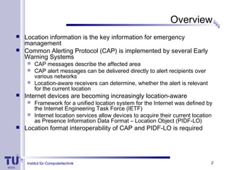
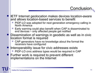
Institut für
Computertechnik
ICT
Institute of
Computer Technology
Location Information
Interoperability of
CAP and PIDF-LO for
Early Warning Systems
Karl Wolf
Institut für Computertechnik 2
Overview
 Location information is the key information for emergency
management
 Common Alerting Protocol (CAP) is implemented by several Early
Warning Systems
 CAP messages describe the affected area
 CAP alert messages can be delivered directly to alert recipients over
various networks
 Location-aware receivers can determine, whether the alert is relevant
for the current location
 Internet devices are becoming increasingly location-aware
 Framework for a unified location system for the Internet was defined by
the Internet Engineering Task Force (IETF)
 Internet location services allow devices to acquire their current location
as Presence Information Data Format – Location Object (PIDF-LO)
 Location format interoperability of CAP and PIDF-LO is required
Institut für Computertechnik 3
Architecture
Architecture implemented as prototype
Institut für Computertechnik 4
Presence Information Data Format –
Location Object (PIDF-LO)
 XML document defined by the IETF
 Geodetic and civic location supported
 Civic address: predefined types (country, A1-A6, street,
house number, …)
 Geodetic location: various shapes (point, polygon, circle,
ellipse, arc band, …)
 Central role in the IETF’s framework for Internet
geolocation (e.g. location configuration protocols)
 Adopted for next generation emergency calling in
North America by the National Emergency Number
Association (NENA)
Institut für Computertechnik 5
The Common Alerting Protocol (CAP)
 CAP 1.2 adopted by Organization for the
Advancement of Structured Information
Standards (OASIS) in 2010
 XML data format for all kinds of alerts
 Affected area
 Textual description
 Geodetic shapes: circle and polygon
 Geocode: name value pair (no predefined names)
Institut für Computertechnik 6
Geodetic Interoperability
 CAP and PIDF-LO are supporting geodetic
location information
 Well known algorithms can be used
 Example: point-in-polygon query to determine,
whether a point in PIDF-LO lies within our
outside boundaries of a CAP polygon
Institut für Computertechnik
Civic Location Interoperability
 PIDF-LO is supporting civic addresses
(predefined elements: country, street, etc.)
 CAP specification does not mention civic
addresses
 CAP has geocode elements (no predefined
elements)
 Structure of civic addresses is more complex
 How to figure out, whether a civic address lies
inside an area?
7
Institut für Computertechnik 8
Civic Location Interoperability - Example
<area>
<areaDesc>
Santa Clarita Valley
</areaDesc>
<geocode>
<valueName>UGC</valueName>
<value>CAZ088</value>
</geocode>
</area>
<cl:civicAddress xml:lang="en">
<cl:country>US</cl:country>
<cl:A1>California</cl:A1>
<cl:A2>Los Angeles County</cl:A2>
<cl:A3>Santa Clarita</cl:A3>
<cl:RD>Railroad</cl:RD>
<cl:STS>Ave</cl:STS>
<cl:HNO>24875</cl:HNO>
<cl:PC>CA 91321</cl:PC>
</cl:civicAddress>
Exemplary CAP area representation (left) and PIDF-LO civic address (right)
Institut für Computertechnik
Options
 Forbid usage of civic addresses in PIDF-LO?
 PIDF-LO is typically generated by a different entity than CAP
 Civic addresses are also supported in the next generation
emergency calling framework
 Civic addresses are suitable for certain scenarios (e.g. location
server serving fixed subscriber line customers)
 Convert civic address to geodetic location?
 Geocoding service necessary
 Error-prone
 Include PIDF-LO civic address elements in CAP?
 New civic address element or full PIDF-LO inside CAP
 Usage of geocode element (used for prototype implementation)
9
Institut für Computertechnik
Example
<area>
<areaDesc>Santa Clarita</areaDesc>
<geocode>
<valueName>PIDF-LO</valueName>
<value>
country="US";A1="California";
A2="Los Angeles County";A3="Santa Clarita“
</value>
</geocode>
</area>
Area representation in CAP with geocode element containing PIDF-LO
civic address elements for interoperability.
10
Institut für Computertechnik 11
Conclusion
 IETF Internet geolocation makes devices location-aware
and allows location-based services to benefit
 PIDF-LO was adopted for next generation emergency calling in
North America
 Early warning could also benefit when CAP is disseminated to
end devices – only affected people get notified
 Dissemination of warnings in geodetic as well as in civic
location format is required
 CAP generators have no knowledge about the format the
receivers have configured
 Interoperability issue for civic addresses exists
 PIDF-LO civic address types would be required in CAP
 Further work is required to prevent different
implementations on the Internet

Location Information Interoperability of CAP and PIDF-LO for Early Warning Systems

  • 1.
    Institut für Computertechnik ICT Institute of ComputerTechnology Location Information Interoperability of CAP and PIDF-LO for Early Warning Systems Karl Wolf
  • 2.
    Institut für Computertechnik2 Overview  Location information is the key information for emergency management  Common Alerting Protocol (CAP) is implemented by several Early Warning Systems  CAP messages describe the affected area  CAP alert messages can be delivered directly to alert recipients over various networks  Location-aware receivers can determine, whether the alert is relevant for the current location  Internet devices are becoming increasingly location-aware  Framework for a unified location system for the Internet was defined by the Internet Engineering Task Force (IETF)  Internet location services allow devices to acquire their current location as Presence Information Data Format – Location Object (PIDF-LO)  Location format interoperability of CAP and PIDF-LO is required
  • 3.
    Institut für Computertechnik3 Architecture Architecture implemented as prototype
  • 4.
    Institut für Computertechnik4 Presence Information Data Format – Location Object (PIDF-LO)  XML document defined by the IETF  Geodetic and civic location supported  Civic address: predefined types (country, A1-A6, street, house number, …)  Geodetic location: various shapes (point, polygon, circle, ellipse, arc band, …)  Central role in the IETF’s framework for Internet geolocation (e.g. location configuration protocols)  Adopted for next generation emergency calling in North America by the National Emergency Number Association (NENA)
  • 5.
    Institut für Computertechnik5 The Common Alerting Protocol (CAP)  CAP 1.2 adopted by Organization for the Advancement of Structured Information Standards (OASIS) in 2010  XML data format for all kinds of alerts  Affected area  Textual description  Geodetic shapes: circle and polygon  Geocode: name value pair (no predefined names)
  • 6.
    Institut für Computertechnik6 Geodetic Interoperability  CAP and PIDF-LO are supporting geodetic location information  Well known algorithms can be used  Example: point-in-polygon query to determine, whether a point in PIDF-LO lies within our outside boundaries of a CAP polygon
  • 7.
    Institut für Computertechnik CivicLocation Interoperability  PIDF-LO is supporting civic addresses (predefined elements: country, street, etc.)  CAP specification does not mention civic addresses  CAP has geocode elements (no predefined elements)  Structure of civic addresses is more complex  How to figure out, whether a civic address lies inside an area? 7
  • 8.
    Institut für Computertechnik8 Civic Location Interoperability - Example <area> <areaDesc> Santa Clarita Valley </areaDesc> <geocode> <valueName>UGC</valueName> <value>CAZ088</value> </geocode> </area> <cl:civicAddress xml:lang="en"> <cl:country>US</cl:country> <cl:A1>California</cl:A1> <cl:A2>Los Angeles County</cl:A2> <cl:A3>Santa Clarita</cl:A3> <cl:RD>Railroad</cl:RD> <cl:STS>Ave</cl:STS> <cl:HNO>24875</cl:HNO> <cl:PC>CA 91321</cl:PC> </cl:civicAddress> Exemplary CAP area representation (left) and PIDF-LO civic address (right)
  • 9.
    Institut für Computertechnik Options Forbid usage of civic addresses in PIDF-LO?  PIDF-LO is typically generated by a different entity than CAP  Civic addresses are also supported in the next generation emergency calling framework  Civic addresses are suitable for certain scenarios (e.g. location server serving fixed subscriber line customers)  Convert civic address to geodetic location?  Geocoding service necessary  Error-prone  Include PIDF-LO civic address elements in CAP?  New civic address element or full PIDF-LO inside CAP  Usage of geocode element (used for prototype implementation) 9
  • 10.
    Institut für Computertechnik Example <area> <areaDesc>SantaClarita</areaDesc> <geocode> <valueName>PIDF-LO</valueName> <value> country="US";A1="California"; A2="Los Angeles County";A3="Santa Clarita“ </value> </geocode> </area> Area representation in CAP with geocode element containing PIDF-LO civic address elements for interoperability. 10
  • 11.
    Institut für Computertechnik11 Conclusion  IETF Internet geolocation makes devices location-aware and allows location-based services to benefit  PIDF-LO was adopted for next generation emergency calling in North America  Early warning could also benefit when CAP is disseminated to end devices – only affected people get notified  Dissemination of warnings in geodetic as well as in civic location format is required  CAP generators have no knowledge about the format the receivers have configured  Interoperability issue for civic addresses exists  PIDF-LO civic address types would be required in CAP  Further work is required to prevent different implementations on the Internet

Editor's Notes

  • #9 UGC (Universal Geographic Code)