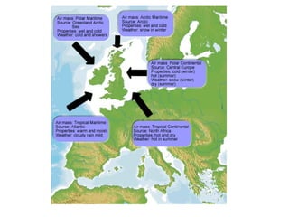
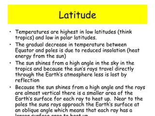
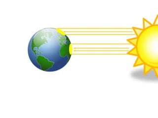
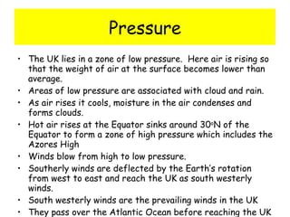
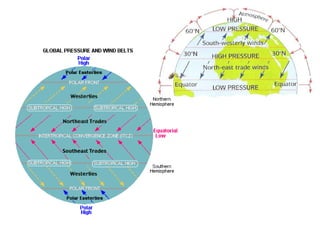
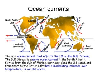
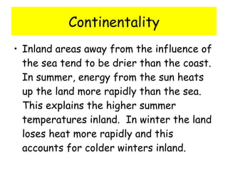
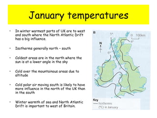
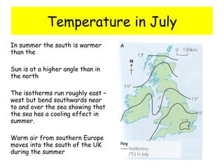
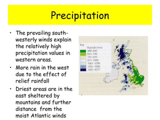
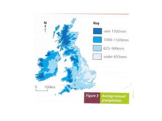
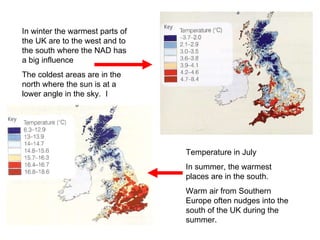
The characteristics of the UK climate can be explained by its global position . Textbook page 54
OBJECTIVES To know the characteristics of the UK climate – monthly temperatures, precipitation, sunshine hours. To be able to explain the reasons for the climate and variations within the UK with reference to latitude, altitude, pressure, winds and distance from the sea.
What is the climate of the UK? Temperate maritime climate Mild wet winters and warm wet summers Temperate = experiences neither the heat of the tropics nor the intense cold of the Poles Maritime – the climate is strongly influenced by the sea. The sea reduces the temperature differences between winter and summer and also increases precipitation
Global position influences: The climate of the UK because two distinctly different types of air mass battle for control over the mid latitudes The relative position of the sun in the sky  The impact of the seasons
 
Factors that control our climate Latitude Ocean currents Prevailing winds Maritime influence Continentality Altitude
Latitude Temperatures are highest in low latitudes (think tropics) and low in polar latitudes. The gradual decrease in temperature between Equator and poles is due to reduced insolation (heat energy from the sun) The sun shines from a high angle in the sky in the tropics and because the sun’s rays travel directly through the Earth’s atmosphere less is lost by reflection Because the sun shines from a high angle and the rays are almost vertical there is a smaller area of the Earth’s surface for each ray to heat up.  Near to the poles the suns rays approach the Earth’s surface at an oblique angle which means that each ray has a larger surface area to heat up.
 
Pressure The UK lies in a zone of low pressure.  Here air is rising so that the weight of air at the surface becomes lower than average. Areas of low pressure are associated with cloud and rain. As air rises it cools, moisture in the air condenses and forms clouds. Hot air rises at the Equator sinks around 30 o N of the Equator to form a zone of high pressure which includes the Azores High Winds blow from high to low pressure. Southerly winds are deflected by the Earth’s rotation from west to east and reach the UK as south westerly winds. South westerly winds are the prevailing winds in the UK They pass over the Atlantic Ocean before reaching the UK
 
Prevailing winds Winds that blow from the sea often bring rain to the coast and dry weather to inland areas.  Winds that blow to Britain from warm inland areas such as Africa will be warm and dry.  Winds that blow to Britain from inland areas such as the Netherlands will be cold and dry in winter.  Britains prevailing winds come from a south westerly direction over the Atlantic. This is why we have a mild but damp climate with wind mostly approaching the UK from a warm ocean
Ocean currents The main  ocean current that affects the UK is the Gulf Stream .  The Gulf Stream is a  warm ocean current  in the North Atlantic flowing from the Gulf of Mexico, northeast along the U.S coast, and from there to the British Isles  has a moderating influence over temperatures in coastal areas.
Maritime influence The proximity of the sea affects the both the temperature and precipitation of a place.  Coastal areas are cooler and wetter than inland areas in summer and milder in winter. Clouds form when warm air from inland areas meets cool air from the sea.  
Continentality Inland areas away from the influence of the sea tend to be drier than the coast.  In summer, energy from the sun heats up the land more rapidly than the sea.  This explains the higher summer temperatures inland.  In winter the land loses heat more rapidly and this accounts for colder winters inland.   
Altitude Upland areas tend to record higher amounts of precipitation as air is forced to rise up and over them Temperatures decrease with altitude  which is why it is colder in upland areas
January temperatures In winter warmest parts of UK are to west and south where the North Atlantic Drift has a big influence. Isotherms generally north – south Coldest areas are in the north where the sun is at a lower angle in the sky Cold over the mountainous areas due to altitude Cold polar air moving south is likely to have more influence in the north of the UK than in the south Winter warmth of sea and North Atlantic Drift is important to west of Britain.
Temperature in July In summer the south is warmer than the  Sun is at a higher angle than in the north The isotherms run roughly east – west but bend southwards near to and over the sea showing that the sea has a cooling effect in summer. Warm air from southern Europe moves into the south of the UK during the summer
Precipitation The prevailing south-westerly winds explain the relatively high precipitation values in western areas. More rain in the west due to the effect of relief rainfall Driest areas are in the east sheltered by mountains and further distance  from the moist Atlantic winds
 
In winter the warmest parts of the UK are to the west and to the south where the NAD has a big influence The coldest areas are in the north where the sun is at a lower angle in the sky.  I Temperature in July In summer, the warmest places are in the south.  Warm air from Southern Europe often nudges into the south of the UK during the summer.
Sunshine The highest values are in the south and east, sheltered from the relatively moist and cloudy south westerly winds Anticyclones fro the south that bring stable and cloud free conditions often affect coastal areas in the south upland areas tend to have less sunshine than lowland regions as air rising over the mountains cools to form clouds
Exam Q  AQA 2005 Q9 Using  Figure 14 , describe the pattern of temperature in Great Britain in July. (2marks) Explain why the patterns of isotherms in Great Britain in January and July are different. (6 marks)
2005 Q9A(i) Needs pattern / trends, e.g. temperature decreases from south to north (1), illustration with figure (1),  temperatures higher over land or inland Isotherms tend to bend northwards over the land (1), etc.  Do not accept single named location on own.  2 marks
2005 Q9A (ii)  Level 1: (1 – 2 marks)  Basic e.g. the south is closer to the sun in July so it is hotter.  In winter, the west coast is warmer because of the warm current. Level 2: (3 – 4 marks)  Clear  The sun shines from the south so the south of England receives more of the sun’s energy. Further north the sun must travel further through the atmosphere so less energy is received. In winter, the east coast is colder because of cold north east winds and there is no warming effect from the North Atlantic Drift.  Heat Island Effect, differential heating of land and sea, all acceptable but not reference to altitude.  Allow imbalance between summer-winter to top of L2. Level 3: (5 – 6 marks)  Detailed  In summer, the main impact on temperature is the energy from the sun whereas in winter, the sun is so low in the sky that distance from the sea and warm ocean currents have a greater impact.  Temperatures decrease as you move north in summer as the surface area being heated increases as does the distance through the atmosphere that the rays must travel. Hence, more energy is lost through scattering. In winter, the west coast is warmer due to the warm North Atlantic Drift and onshore winds that keep temperatures slightly higher.  6 marks

1. Characteristics Uk Climate

  • 1.
    The characteristics ofthe UK climate can be explained by its global position . Textbook page 54
  • 2.
    OBJECTIVES To knowthe characteristics of the UK climate – monthly temperatures, precipitation, sunshine hours. To be able to explain the reasons for the climate and variations within the UK with reference to latitude, altitude, pressure, winds and distance from the sea.
  • 3.
    What is theclimate of the UK? Temperate maritime climate Mild wet winters and warm wet summers Temperate = experiences neither the heat of the tropics nor the intense cold of the Poles Maritime – the climate is strongly influenced by the sea. The sea reduces the temperature differences between winter and summer and also increases precipitation
  • 4.
    Global position influences:The climate of the UK because two distinctly different types of air mass battle for control over the mid latitudes The relative position of the sun in the sky The impact of the seasons
  • 5.
  • 6.
    Factors that controlour climate Latitude Ocean currents Prevailing winds Maritime influence Continentality Altitude
  • 7.
    Latitude Temperatures arehighest in low latitudes (think tropics) and low in polar latitudes. The gradual decrease in temperature between Equator and poles is due to reduced insolation (heat energy from the sun) The sun shines from a high angle in the sky in the tropics and because the sun’s rays travel directly through the Earth’s atmosphere less is lost by reflection Because the sun shines from a high angle and the rays are almost vertical there is a smaller area of the Earth’s surface for each ray to heat up. Near to the poles the suns rays approach the Earth’s surface at an oblique angle which means that each ray has a larger surface area to heat up.
  • 8.
  • 9.
    Pressure The UKlies in a zone of low pressure. Here air is rising so that the weight of air at the surface becomes lower than average. Areas of low pressure are associated with cloud and rain. As air rises it cools, moisture in the air condenses and forms clouds. Hot air rises at the Equator sinks around 30 o N of the Equator to form a zone of high pressure which includes the Azores High Winds blow from high to low pressure. Southerly winds are deflected by the Earth’s rotation from west to east and reach the UK as south westerly winds. South westerly winds are the prevailing winds in the UK They pass over the Atlantic Ocean before reaching the UK
  • 10.
  • 11.
    Prevailing winds Windsthat blow from the sea often bring rain to the coast and dry weather to inland areas.  Winds that blow to Britain from warm inland areas such as Africa will be warm and dry.  Winds that blow to Britain from inland areas such as the Netherlands will be cold and dry in winter.  Britains prevailing winds come from a south westerly direction over the Atlantic. This is why we have a mild but damp climate with wind mostly approaching the UK from a warm ocean
  • 12.
    Ocean currents Themain ocean current that affects the UK is the Gulf Stream . The Gulf Stream is a warm ocean current in the North Atlantic flowing from the Gulf of Mexico, northeast along the U.S coast, and from there to the British Isles has a moderating influence over temperatures in coastal areas.
  • 13.
    Maritime influence Theproximity of the sea affects the both the temperature and precipitation of a place.  Coastal areas are cooler and wetter than inland areas in summer and milder in winter. Clouds form when warm air from inland areas meets cool air from the sea.  
  • 14.
    Continentality Inland areasaway from the influence of the sea tend to be drier than the coast. In summer, energy from the sun heats up the land more rapidly than the sea. This explains the higher summer temperatures inland. In winter the land loses heat more rapidly and this accounts for colder winters inland.   
  • 15.
    Altitude Upland areastend to record higher amounts of precipitation as air is forced to rise up and over them Temperatures decrease with altitude which is why it is colder in upland areas
  • 16.
    January temperatures Inwinter warmest parts of UK are to west and south where the North Atlantic Drift has a big influence. Isotherms generally north – south Coldest areas are in the north where the sun is at a lower angle in the sky Cold over the mountainous areas due to altitude Cold polar air moving south is likely to have more influence in the north of the UK than in the south Winter warmth of sea and North Atlantic Drift is important to west of Britain.
  • 17.
    Temperature in JulyIn summer the south is warmer than the Sun is at a higher angle than in the north The isotherms run roughly east – west but bend southwards near to and over the sea showing that the sea has a cooling effect in summer. Warm air from southern Europe moves into the south of the UK during the summer
  • 18.
    Precipitation The prevailingsouth-westerly winds explain the relatively high precipitation values in western areas. More rain in the west due to the effect of relief rainfall Driest areas are in the east sheltered by mountains and further distance from the moist Atlantic winds
  • 19.
  • 20.
    In winter thewarmest parts of the UK are to the west and to the south where the NAD has a big influence The coldest areas are in the north where the sun is at a lower angle in the sky. I Temperature in July In summer, the warmest places are in the south. Warm air from Southern Europe often nudges into the south of the UK during the summer.
  • 21.
    Sunshine The highestvalues are in the south and east, sheltered from the relatively moist and cloudy south westerly winds Anticyclones fro the south that bring stable and cloud free conditions often affect coastal areas in the south upland areas tend to have less sunshine than lowland regions as air rising over the mountains cools to form clouds
  • 22.
    Exam Q AQA 2005 Q9 Using Figure 14 , describe the pattern of temperature in Great Britain in July. (2marks) Explain why the patterns of isotherms in Great Britain in January and July are different. (6 marks)
  • 23.
    2005 Q9A(i) Needspattern / trends, e.g. temperature decreases from south to north (1), illustration with figure (1), temperatures higher over land or inland Isotherms tend to bend northwards over the land (1), etc. Do not accept single named location on own. 2 marks
  • 24.
    2005 Q9A (ii) Level 1: (1 – 2 marks) Basic e.g. the south is closer to the sun in July so it is hotter. In winter, the west coast is warmer because of the warm current. Level 2: (3 – 4 marks) Clear The sun shines from the south so the south of England receives more of the sun’s energy. Further north the sun must travel further through the atmosphere so less energy is received. In winter, the east coast is colder because of cold north east winds and there is no warming effect from the North Atlantic Drift. Heat Island Effect, differential heating of land and sea, all acceptable but not reference to altitude. Allow imbalance between summer-winter to top of L2. Level 3: (5 – 6 marks) Detailed In summer, the main impact on temperature is the energy from the sun whereas in winter, the sun is so low in the sky that distance from the sea and warm ocean currents have a greater impact. Temperatures decrease as you move north in summer as the surface area being heated increases as does the distance through the atmosphere that the rays must travel. Hence, more energy is lost through scattering. In winter, the west coast is warmer due to the warm North Atlantic Drift and onshore winds that keep temperatures slightly higher. 6 marks