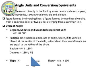
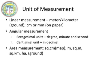
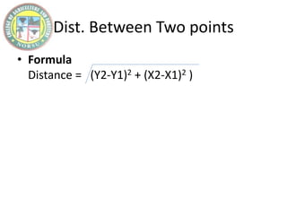
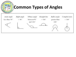
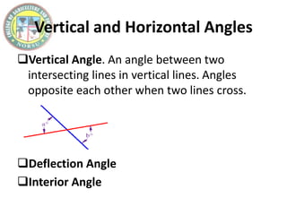
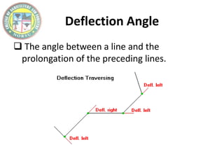
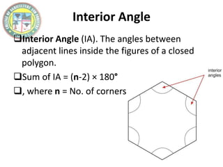
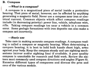
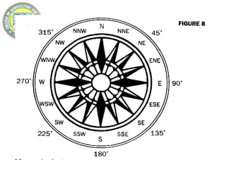
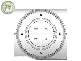
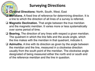
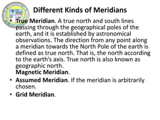
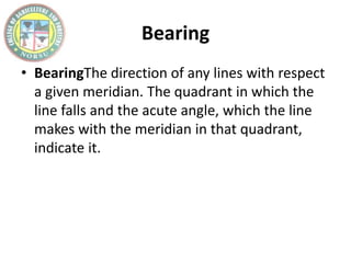
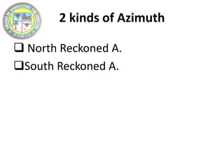
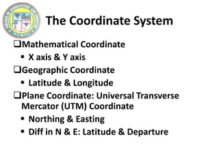
Angles and Directions
Angle Units and Conversion/Equivalents
 Angles. Measured directly in the field by some device such as compass,
transit, theodolite, sextant or plane table and alidade.
 figure formed by diverging lines: a figure formed by two lines diverging
from a common point or two planes diverging from a common line.
 Units of Angles
 Degrees, Minutes and Seconds/sexagesimal units
 Radians. One radian is a measure of angle, which, if its vertex is
placed at the center of the circle, subtends on the circumference an
arc equal to the radius of the circle.
Radian = (Pi / 180o)
Degrees = (180o / Pi)
 Slope (%) slope Slope= rise x 100
rise run
run
Unit of Measurement
• Linear measurement – meter/kilometer
(ground); cm or mm (on paper)
• Angular measurement
I. Sexagesimal units – degree, minute and second
II. Centisimal unit – in decimal
• Area measurement: sq.cm(map); m, sq.m,
sq.km, ha. (ground)
Dist. Between Two points
• Formula
Distance = (Y2-Y1)2 + (X2-X1)2 )
Common Types of Angles
Vertical and Horizontal Angles
Vertical Angle. An angle between two
intersecting lines in vertical lines. Angles
opposite each other when two lines cross.
Deflection Angle
Interior Angle
Deflection Angle
 The angle between a line and the
prolongation of the preceding lines.
Interior Angle
Interior Angle (IA). The angles between
adjacent lines inside the figures of a closed
polygon.
Sum of IA = (n-2) × 180°
, where n = No. of corners
Surveying Directions
 Cardinal Directions: North, South, West, East
 Meridians. A fixed line of reference for determining direction. It is
a line to which the direction of all lines of a survey is referred.
 Magnetic Declination. That angle between the true meridian
and the magnetic meridian. It varies more or less systematically
over some period of time.
 Bearing. The direction of any lines with respect a given meridian.
The quadrant in which the line falls and the acute angle, which
the line makes with the meridian in that quadrant, indicate it.
 Azimuths. A line with its direction as given by the angle between
the meridian and the line, measured in a clockwise direction
usually from the south point of the meridian. The clockwise angle
designated of being measured either the north end or south end
of the reference meridian and the line in question.
Different Kinds of Meridians
• True Meridian. A true north and south lines
passing through the geographical poles of the
earth, and it is established by astronomical
observations. The direction from any point along
a meridian towards the North Pole of the earth is
defined as true north. That is, the north according
to the earth’s axis. True north is also known as
geographic north.
Magnetic Meridian.
• Assumed Meridian. If the meridian is arbitrarily
chosen.
• Grid Meridian.
Bearing
• BearingThe direction of any lines with respect
a given meridian. The quadrant in which the
line falls and the acute angle, which the line
makes with the meridian in that quadrant,
indicate it.
2 kinds of Azimuth
 North Reckoned A.
South Reckoned A.
Solve:
The Coordinate System
Mathematical Coordinate
 X axis & Y axis
Geographic Coordinate
 Latitude & Longitude
Plane Coordinate: Universal Transverse
Mercator (UTM) Coordinate
 Northing & Easting
 Diff in N & E: Latitude & Departure
END…

02.1 - Angles and Directions.pptx

  • 1.
  • 2.
    Angle Units andConversion/Equivalents  Angles. Measured directly in the field by some device such as compass, transit, theodolite, sextant or plane table and alidade.  figure formed by diverging lines: a figure formed by two lines diverging from a common point or two planes diverging from a common line.  Units of Angles  Degrees, Minutes and Seconds/sexagesimal units  Radians. One radian is a measure of angle, which, if its vertex is placed at the center of the circle, subtends on the circumference an arc equal to the radius of the circle. Radian = (Pi / 180o) Degrees = (180o / Pi)  Slope (%) slope Slope= rise x 100 rise run run
  • 3.
    Unit of Measurement •Linear measurement – meter/kilometer (ground); cm or mm (on paper) • Angular measurement I. Sexagesimal units – degree, minute and second II. Centisimal unit – in decimal • Area measurement: sq.cm(map); m, sq.m, sq.km, ha. (ground)
  • 4.
    Dist. Between Twopoints • Formula Distance = (Y2-Y1)2 + (X2-X1)2 )
  • 5.
  • 6.
    Vertical and HorizontalAngles Vertical Angle. An angle between two intersecting lines in vertical lines. Angles opposite each other when two lines cross. Deflection Angle Interior Angle
  • 7.
    Deflection Angle  Theangle between a line and the prolongation of the preceding lines.
  • 8.
    Interior Angle Interior Angle(IA). The angles between adjacent lines inside the figures of a closed polygon. Sum of IA = (n-2) × 180° , where n = No. of corners
  • 14.
    Surveying Directions  CardinalDirections: North, South, West, East  Meridians. A fixed line of reference for determining direction. It is a line to which the direction of all lines of a survey is referred.  Magnetic Declination. That angle between the true meridian and the magnetic meridian. It varies more or less systematically over some period of time.  Bearing. The direction of any lines with respect a given meridian. The quadrant in which the line falls and the acute angle, which the line makes with the meridian in that quadrant, indicate it.  Azimuths. A line with its direction as given by the angle between the meridian and the line, measured in a clockwise direction usually from the south point of the meridian. The clockwise angle designated of being measured either the north end or south end of the reference meridian and the line in question.
  • 15.
    Different Kinds ofMeridians • True Meridian. A true north and south lines passing through the geographical poles of the earth, and it is established by astronomical observations. The direction from any point along a meridian towards the North Pole of the earth is defined as true north. That is, the north according to the earth’s axis. True north is also known as geographic north. Magnetic Meridian. • Assumed Meridian. If the meridian is arbitrarily chosen. • Grid Meridian.
  • 16.
    Bearing • BearingThe directionof any lines with respect a given meridian. The quadrant in which the line falls and the acute angle, which the line makes with the meridian in that quadrant, indicate it.
  • 17.
    2 kinds ofAzimuth  North Reckoned A. South Reckoned A.
  • 18.
  • 19.
    The Coordinate System MathematicalCoordinate  X axis & Y axis Geographic Coordinate  Latitude & Longitude Plane Coordinate: Universal Transverse Mercator (UTM) Coordinate  Northing & Easting  Diff in N & E: Latitude & Departure
  • 20.