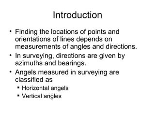
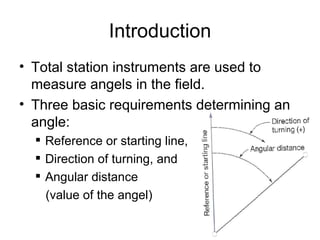
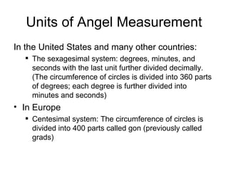
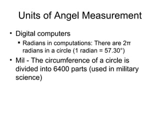
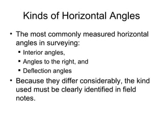
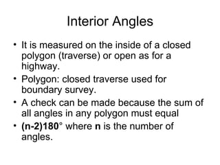
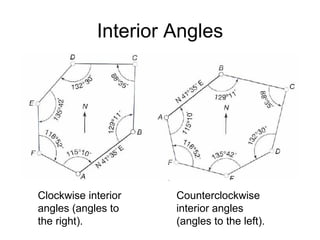
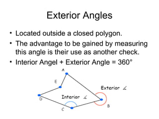
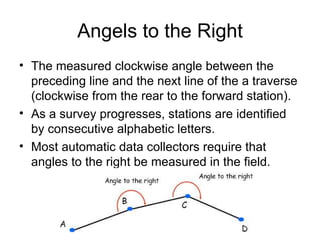
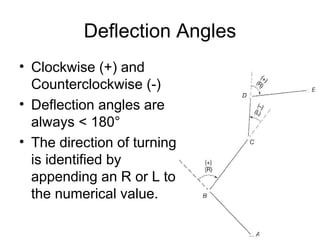
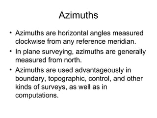
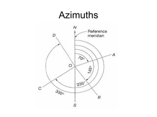
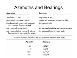
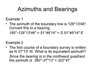
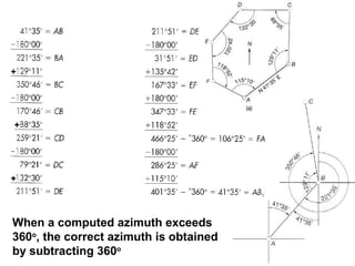
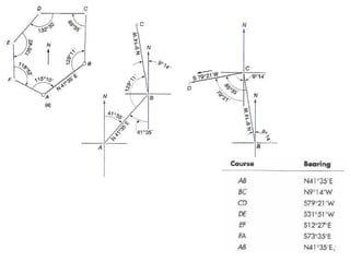
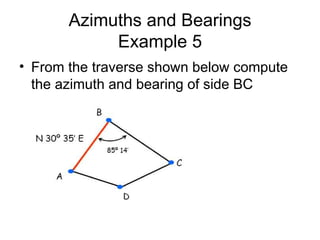
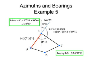
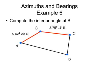
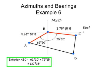
Surveying & Measurement
Angles, Azimuths and Bearings
Introduction
• Finding the locations of points and
orientations of lines depends on
measurements of angles and directions.
• In surveying, directions are given by
azimuths and bearings.
• Angels measured in surveying are
classified as
 Horizontal angels
 Vertical angles
Introduction
• Total station instruments are used to
measure angels in the field.
• Three basic requirements determining an
angle:
 Reference or starting line,
 Direction of turning, and
 Angular distance
(value of the angel)
Units of Angel Measurement
In the United States and many other countries:
 The sexagesimal system: degrees, minutes, and
seconds with the last unit further divided decimally.
(The circumference of circles is divided into 360 parts
of degrees; each degree is further divided into
minutes and seconds)
• In Europe
 Centesimal system: The circumference of circles is
divided into 400 parts called gon (previously called
grads)
Units of Angel Measurement
• Digital computers
 Radians in computations: There are 2π
radians in a circle (1 radian = 57.30°)
• Mil - The circumference of a circle is
divided into 6400 parts (used in military
science)
Kinds of Horizontal Angles
• The most commonly measured horizontal
angles in surveying:
 Interior angles,
 Angles to the right, and
 Deflection angles
• Because they differ considerably, the kind
used must be clearly identified in field
notes.
Interior Angles
• It is measured on the inside of a closed
polygon (traverse) or open as for a
highway.
• Polygon: closed traverse used for
boundary survey.
• A check can be made because the sum of
all angles in any polygon must equal
• (n-2)180° where n is the number of
angles.
Interior Angles
Clockwise interior
angles (angles to
the right).
Counterclockwise
interior angles
(angles to the left).
Exterior Angles
• Located outside a closed polygon.
• The advantage to be gained by measuring
this angle is their use as another check.
• Interior Angel + Exterior Angle = 360°
Angels to the Right
• The measured clockwise angle between the
preceding line and the next line of the a traverse
(clockwise from the rear to the forward station).
• As a survey progresses, stations are identified
by consecutive alphabetic letters.
• Most automatic data collectors require that
angles to the right be measured in the field.
Angels to the Left
• Turned counterclockwise from the rear
station.
• A serious mistake occurs if
counterclockwise angles are measured
and recorded or assumed to be clockwise.
• To avoid this confusion, always measure
angel to the right and note the direction of
turning in the filed book with a sketch.
Deflection Angles
• Measured from an extension of the back
line, to the forward station.
• Used principally on the long linear
alignments of route surveys.
• Deflection angles may be measured to the
right (clockwise) or to the left
(counterclockwise) depending upon the
direction of the route.
Deflection Angles
• Clockwise (+) and
Counterclockwise (-)
• Deflection angles are
always < 180°
• The direction of turning
is identified by
appending an R or L to
the numerical value.
Azimuths
• Azimuths are horizontal angles measured
clockwise from any reference meridian.
• In plane surveying, azimuths are generally
measured from north.
• Azimuths are used advantageously in
boundary, topographic, control, and other
kinds of surveys, as well as in
computations.
Azimuths
Azimuths
• Every line has two azimuths (forward and
back) and their values differ by 180°
• Azimuth are referred to astronomic,
magnetic, or assumed meridian
• For example: the forward azimuth of line
AB is 50° - the back azimuth or azimuth
of BA is 230° North North
Meridians
• There are three types of meridians
 Astronomic - direction determined from the
shape of the earth and gravity; also called
geodetic north
 Magnetic - direction taken by a magnetic
needle at observer’s position
 Assumed - subjective direction taken for
convenience
Bearing
• Bearings are another systems for designating
directions of lines.
• The bearing of a line is defined as the acute
horizontal angle between a reference meridian
and the line.
• Measured from either the north or south toward
the east or west, to give a reading smaller than
90°.
• For example; N70°E, N30°W, S35°E, and
S55°W
Bearing
Bearing
• Assume that total station is set up at
points A, B, C, and D; bearings read on
lines AB, BA, BC, CB, CD, and DC.
• AB, BC, and CD are Forward bearings
• BA, CB, and DC are Back bearings
• Back bearings should have the same
numerical values as forward bearings but
opposite letters.
Bearing
• Bearing AB = N44°E, bearing BA =S44°W
A B
C
D
N N
N
N
Azimuths and Bearings
Example 1
• The azimuth of the boundary line is 128°13'46".
Convert this to a bearing.
180°-128°13'46" = 51°46'14" = S 51°46'14" E
Example 2
• The first course of a boundary survey is written
as N 37°13' W. What is its equivalent azimuth?
Since the bearing is in the northwest quadrant,
the azimuth is 360°-37°13' = 322°47'
When a computed azimuth exceeds
360o
, the correct azimuth is obtained
by subtracting 360o
+
+
+
Azimuths and Bearings
• If the bearing or azimuth of one side of
traverse has been determined and the
angles between the sides have been
measured, the bearings or azimuths of
the other sides can be computed
• One technique to solve most of these
problems is to use the deflection angles
Azimuths and Bearings
Example 5
• From the traverse shown below compute
the azimuth and bearing of side BC
Azimuths and Bearings
Example 5
Azimuths and Bearings
Example 6
• Compute the interior angle at B
Azimuths and Bearings
Example 6

no. 6 class note surveying measurements lecture note

  • 1.
    Surveying & Measurement Angles,Azimuths and Bearings
  • 2.
    Introduction • Finding thelocations of points and orientations of lines depends on measurements of angles and directions. • In surveying, directions are given by azimuths and bearings. • Angels measured in surveying are classified as  Horizontal angels  Vertical angles
  • 3.
    Introduction • Total stationinstruments are used to measure angels in the field. • Three basic requirements determining an angle:  Reference or starting line,  Direction of turning, and  Angular distance (value of the angel)
  • 4.
    Units of AngelMeasurement In the United States and many other countries:  The sexagesimal system: degrees, minutes, and seconds with the last unit further divided decimally. (The circumference of circles is divided into 360 parts of degrees; each degree is further divided into minutes and seconds) • In Europe  Centesimal system: The circumference of circles is divided into 400 parts called gon (previously called grads)
  • 5.
    Units of AngelMeasurement • Digital computers  Radians in computations: There are 2π radians in a circle (1 radian = 57.30°) • Mil - The circumference of a circle is divided into 6400 parts (used in military science)
  • 6.
    Kinds of HorizontalAngles • The most commonly measured horizontal angles in surveying:  Interior angles,  Angles to the right, and  Deflection angles • Because they differ considerably, the kind used must be clearly identified in field notes.
  • 7.
    Interior Angles • Itis measured on the inside of a closed polygon (traverse) or open as for a highway. • Polygon: closed traverse used for boundary survey. • A check can be made because the sum of all angles in any polygon must equal • (n-2)180° where n is the number of angles.
  • 8.
    Interior Angles Clockwise interior angles(angles to the right). Counterclockwise interior angles (angles to the left).
  • 9.
    Exterior Angles • Locatedoutside a closed polygon. • The advantage to be gained by measuring this angle is their use as another check. • Interior Angel + Exterior Angle = 360°
  • 10.
    Angels to theRight • The measured clockwise angle between the preceding line and the next line of the a traverse (clockwise from the rear to the forward station). • As a survey progresses, stations are identified by consecutive alphabetic letters. • Most automatic data collectors require that angles to the right be measured in the field.
  • 11.
    Angels to theLeft • Turned counterclockwise from the rear station. • A serious mistake occurs if counterclockwise angles are measured and recorded or assumed to be clockwise. • To avoid this confusion, always measure angel to the right and note the direction of turning in the filed book with a sketch.
  • 12.
    Deflection Angles • Measuredfrom an extension of the back line, to the forward station. • Used principally on the long linear alignments of route surveys. • Deflection angles may be measured to the right (clockwise) or to the left (counterclockwise) depending upon the direction of the route.
  • 13.
    Deflection Angles • Clockwise(+) and Counterclockwise (-) • Deflection angles are always < 180° • The direction of turning is identified by appending an R or L to the numerical value.
  • 14.
    Azimuths • Azimuths arehorizontal angles measured clockwise from any reference meridian. • In plane surveying, azimuths are generally measured from north. • Azimuths are used advantageously in boundary, topographic, control, and other kinds of surveys, as well as in computations.
  • 15.
  • 16.
    Azimuths • Every linehas two azimuths (forward and back) and their values differ by 180° • Azimuth are referred to astronomic, magnetic, or assumed meridian • For example: the forward azimuth of line AB is 50° - the back azimuth or azimuth of BA is 230° North North
  • 17.
    Meridians • There arethree types of meridians  Astronomic - direction determined from the shape of the earth and gravity; also called geodetic north  Magnetic - direction taken by a magnetic needle at observer’s position  Assumed - subjective direction taken for convenience
  • 18.
    Bearing • Bearings areanother systems for designating directions of lines. • The bearing of a line is defined as the acute horizontal angle between a reference meridian and the line. • Measured from either the north or south toward the east or west, to give a reading smaller than 90°. • For example; N70°E, N30°W, S35°E, and S55°W
  • 19.
  • 20.
    Bearing • Assume thattotal station is set up at points A, B, C, and D; bearings read on lines AB, BA, BC, CB, CD, and DC. • AB, BC, and CD are Forward bearings • BA, CB, and DC are Back bearings • Back bearings should have the same numerical values as forward bearings but opposite letters.
  • 21.
    Bearing • Bearing AB= N44°E, bearing BA =S44°W A B C D N N N N
  • 22.
  • 23.
    Azimuths and Bearings Example1 • The azimuth of the boundary line is 128°13'46". Convert this to a bearing. 180°-128°13'46" = 51°46'14" = S 51°46'14" E Example 2 • The first course of a boundary survey is written as N 37°13' W. What is its equivalent azimuth? Since the bearing is in the northwest quadrant, the azimuth is 360°-37°13' = 322°47'
  • 24.
    When a computedazimuth exceeds 360o , the correct azimuth is obtained by subtracting 360o + + +
  • 26.
    Azimuths and Bearings •If the bearing or azimuth of one side of traverse has been determined and the angles between the sides have been measured, the bearings or azimuths of the other sides can be computed • One technique to solve most of these problems is to use the deflection angles
  • 27.
    Azimuths and Bearings Example5 • From the traverse shown below compute the azimuth and bearing of side BC
  • 28.
  • 29.
    Azimuths and Bearings Example6 • Compute the interior angle at B
  • 30.