SlideShare a Scribd company logo
1 of 17
Forest Biomass Estimation using GIS
A Group Presentation on
GIS Application in Natural Resources FSE (701)
Group: Syntax
S.N. Name Class Roll no. S.N. Name Class Roll no.
1. Binita K.C. 5 5. Rabin Thapa 25
2. Kusum Saru 15 6. Santosh Ghimire 34
3. Niranjan Paudel 19 7. Susmita Khanal 39
4. Prabesh Adhikari 22 8. Yamuna Paudel 43
Submitted to: Assistant Professor Jeetendra Gautam
OUTLINE OF THE PRESENTATION
INTRODUCTION
OBJECTIVES
METHODOLOGY
FINDINGS AND RESULT
CONCLUSION
REFERENCES
1
3/21/2022
INTRODUCTION
Biomass is defined as mass of live or dead organic matter that includes the above-
ground and below-ground living biomass, dead mass, and litter (GTOS, 2009).
The largest carbon pool are typically stored in the above-ground living biomass. Thus
estimating above-ground forest biomass (AGB) is the most important step in
quantifying carbon stocks from forests (Gibbs et al., 2007).
The most accurate ways of calculating biomass data is based on field measurement
through destructive sampling or allometric equations method (Englhart et al., 2011).
However, these methods are often cost and time consuming, labor intensive, have
limited spatial distribution, and impractical especially in remote areas (Englhart et al.,
2011).
Remote sensing techniques have the capacity to overcome the limitations of
conventional field measurement methods and have now become the primary source in
estimating AGB (Lu, 2006).
2
3/21/2022
INTRODUCTION
These methods have been explored in terms of biomass and its changes to increase our
understanding of the role of forests in the carbon cycle for greenhouse gas inventories
and terrestrial carbon accounting (Muukkonen & Heiskanen, 2007).
Although much research has explored biomass estimation using remote sensing
technology methods to select suitable variables from remote sensing data and develop
estimation models suitable for specific studies are still poorly understood.
It is crucial to summarize the current status of remote sensing-based biomass
estimation techniques and discuss potential solutions to improve biomass estimation
performance.
3
3/21/2022
OBJECTIVES
General Objective:
To estimate the biomass of forest using GIS.
Specific Objective:
To calculate above ground biomass of Milanchowk CF from field inventory.
To establish a regression model between aboveground biomass and Sentinel 2
image.
4
3/21/2022
METHODOLOGY
Study Area:
The study was carried out in the
Milanchowk Community Forest, located
in Chitlang, Makawapur District.
It is extended from 27.34'52" N to
27.40'59"N and 85.01'21"E to 85.12'20"E
The average annual rainfall has been
recorded as 1863mm/year.
The dominant species of the study area
are Pinus and Quercus species.
5
3/21/2022
METHODOLOGY
Methodology Steps:
1) Download Sentinel 2 imaginary from USGS Earth Explorer.
2) Add Sentinel 2 imaginary data in Arc GIS 10.8 and calculate NDVI value.
3) Add boundary and sample plot point of CF.
4) Calculate Red band, Green bend, Blue band, NIR and NDVI value of
sample point.
5) Develop equation (Biomass vs Red, Green, Blue, NIR, NDVI Value) from
R-Studio programming software.
6) Validation Analysis using Paired t-test.
6
3/21/2022
METHODOLOGY
Data Collection:
7
3/21/2022
S.N. Data collection Activities
1. Primary data
collection
 The systematic sampling method with 10m * 10m sample plot
is used for field measurement.
 The biomass is estimated by using the equation: AGB =
0.0509 * pD2H (Where, AGB = above-ground tree biomass
[kg]; p = wood specific gravity [g/cm3; D = tree diameter at
breast height [cm]; and H = tree height [m])
 Sentinel 2 image is used to calculated NDVI Value.
2. Secondary data
collection
 Books
 Journals
 Article
 Reports
FINDINGS AND RESULT
8
3/21/2022
Sample plot Biomass (kg)
1 1602
2 1429
3 1490
4 948
5 2164
6 1956
7 1253
8 572
9 1479
10 1080
11 1094
12 653
13 723
14 1814
15 1118
16 1113
17 845
18 422
19 1669
20 1847
 Out of 30 sample plots, biomass estimation is done
from 20 sample plots which are used to generate the
biomass equation.
 The maximum, minimum and average biomass
estimates from 20 sample plot of Milanchowk C.F.
are 2164 kg, 422 kg and 1263 kg respectively.
Biomass estimation
FINDINGS AND RESULT
9
3/21/2022
NDVI Value:
The high, low and average
NDVI value of Milanchowk
C.F. are 0.38033, 0.23325 and
0.322 respectively.
FINDINGS AND RESULT
S.N. Red Green Blue NIR NDVI
1. 1599 1732 1823 2754 0.265334
2. 1591 1729 1829 3162 0.330528
3. 1510 1685 1796 2699 0.28249
4. 1521 1766 1807 3084 0.339414
5. 1575 1820 1837 3401 0.366961
6. 1569 1768 1824 3128 0.331914
7. 1756 1770 1861 3031 0.266346
8. 1509 1734 1803 2843 0.306526
9. 1512 1716 1806 2804 0.299351
10. 1519 1694 1796 2938 0.318376
11. 1537 1731 1811 3175 0.347623
12. 1579 1729 1813 3006 0.311232
13 1595 1724 1816 2997 0.305314
14. 1575 1715 1811 3292 0.352784
15. 1547 1742 1812 3218 0.350682
16. 1561 1739 1820 3106 0.331048
17. 1559 1741 1817 3083 0.328307
18. 1544 1756 1802 3197 0.348661
19. 1558 1727 1815 3182 0.342616
20. 1562 1746 1817 3057 0.323663
1
0
3/21/2022
The Red band value, Green band
value, Blue band value, NIR value
and NDVI values are tabulated as:
FINDINGS AND RESULT
Equation formulation:
To develop the biomass equation, five independent variables are used i.e.
(Biomass ~ Red band, Green band, Blue band, NIR, NDVI value).
Linear regression equation is used to fit dependent variable with independent
variables.
The fit regression equation derived from biomass modelling is:
Biomass ~ A + B * Red + C * Green + D * Blue + E * NIR + G * NDVI
11
3/21/2022
FINDINGS AND RESULT
The resultant data obtained from R- programme are:
12
3/21/2022
Constant Value
A -7.153034e+03
B -5.855211e+01
C -8.727644e+00
D 4.992052e+01
E 2.665179e+01
G -1.767242e+05
FINDINGS AND RESULT
13
3/21/2022
Equation Validation Analysis:
 Ten sample plots are used for equation
validation analysis.
 The resultant p value obtained from paired t–
test is p=0.08756 > 0.05, which indicates
above biomass equation is valid.
CONCLUSION
The maximum, minimum and average biomass are estimated as 2164 kg, 422 kg and
1263 kg respectively.
The high, low and average NDVI value are 0.38033, 0.23325 and 0.322 respectively.
The best fitted regression equation derived from biomass modelling is Biomass ~ A +
B * Red + C * Green + D * Blue + E * NIR + G * NDVI .
The biomass equation developed from this study can be used by the relevant
institutions, organizations and academics for research purposes as well as forest
management authorities.
14
3/21/2022
REFERENCES
Englhart, S., Keuck, V. & Siegert, F. (2011). Aboveground biomass retrieval in tropical
forest. Remote Sensing of Environment 115, pp. 1260-1271.
Gibbs, H.K., Brown, S., Niles, J.O. & Foley, J.A. (2007). Monitoring and estimating
tropical forest carbon stocks: making REDD a reality. Environmental Research Letters 2
(4), 13pp.
GTOS (Global Terrestrial Observing System). (2009). Assessment of the status of the
development of the standards for the terrestrial essential climate variables: Biomass.
Report FAO.
Lu, D.S. (2006). The potential and challenge of remote sensing-based biomass
estimation. International Journal of Remote Sensing, 27 (7), pp. 1297-1328.
Muukkonen, P. & Heiskanen, J. (2007). Biomass estimation over a large area based on
standwise forest inventory data and ASTER and MODIS satellite data: A possibility to
verify carbon inventories. Remote Sensing of Environment, 107(4), 617-624.
15
3/21/2022
Forest Biomass Estimation using GIS.pptx

More Related Content

What's hot

Gis application on forest management
Gis application on forest managementGis application on forest management
Gis application on forest managementprahladpatel6
 
Remote sensing application in agriculture & forestry_Dr Menon A R R (The Kera...
Remote sensing application in agriculture & forestry_Dr Menon A R R (The Kera...Remote sensing application in agriculture & forestry_Dr Menon A R R (The Kera...
Remote sensing application in agriculture & forestry_Dr Menon A R R (The Kera...India Water Portal
 
Crops yield estimation through remote sensing
Crops yield estimation through remote sensingCrops yield estimation through remote sensing
Crops yield estimation through remote sensingCIMMYT
 
drought monitoring and management using remote sensing
drought monitoring and management using remote sensingdrought monitoring and management using remote sensing
drought monitoring and management using remote sensingveerendra manduri
 
Application of Remote sensing in wasteland Mappings.pptx
Application of Remote sensing in wasteland Mappings.pptxApplication of Remote sensing in wasteland Mappings.pptx
Application of Remote sensing in wasteland Mappings.pptxsapna kinattinkara
 
Chapter 5: Remote sensing
Chapter 5: Remote sensingChapter 5: Remote sensing
Chapter 5: Remote sensingShankar Gangaju
 
Normalized Difference Vegetation Index (NDVI)
Normalized Difference Vegetation Index (NDVI)Normalized Difference Vegetation Index (NDVI)
Normalized Difference Vegetation Index (NDVI)Somenath Goswami
 
Fundamentals of Remote Sensing
Fundamentals of Remote Sensing Fundamentals of Remote Sensing
Fundamentals of Remote Sensing Pallab Jana
 
ROLE OF AGROFORESTRY IN MITIGATION OF CLIMATE CHANGE
ROLE OF AGROFORESTRY IN MITIGATION OF CLIMATE CHANGEROLE OF AGROFORESTRY IN MITIGATION OF CLIMATE CHANGE
ROLE OF AGROFORESTRY IN MITIGATION OF CLIMATE CHANGEGANDLA MANTHESH
 
WE1.L09.5 - ESTIMATION OF FOREST BIOMASS CHANGE FROM FUSION OF RADAR AND LIDA...
WE1.L09.5 - ESTIMATION OF FOREST BIOMASS CHANGE FROM FUSION OF RADAR AND LIDA...WE1.L09.5 - ESTIMATION OF FOREST BIOMASS CHANGE FROM FUSION OF RADAR AND LIDA...
WE1.L09.5 - ESTIMATION OF FOREST BIOMASS CHANGE FROM FUSION OF RADAR AND LIDA...grssieee
 
Surface Analysis in GIS
Surface Analysis in GISSurface Analysis in GIS
Surface Analysis in GISRituSaha3
 
Digital image processing and interpretation
Digital image processing and interpretationDigital image processing and interpretation
Digital image processing and interpretationP.K. Mani
 
Application of GIS in agriculture
Application of GIS in agricultureApplication of GIS in agriculture
Application of GIS in agricultureNishat Fatima
 
Use of remote sensing for land cover monitoring servir science applications
Use of remote sensing for land cover monitoring servir science applicationsUse of remote sensing for land cover monitoring servir science applications
Use of remote sensing for land cover monitoring servir science applicationsKabir Uddin
 
Introduction to Remote Sensing
Introduction to Remote SensingIntroduction to Remote Sensing
Introduction to Remote SensingUday kumar Devalla
 
Atmospheric windows
Atmospheric windowsAtmospheric windows
Atmospheric windowsSadia Rahat
 

What's hot (20)

Gis application on forest management
Gis application on forest managementGis application on forest management
Gis application on forest management
 
Remote sensing application in agriculture & forestry_Dr Menon A R R (The Kera...
Remote sensing application in agriculture & forestry_Dr Menon A R R (The Kera...Remote sensing application in agriculture & forestry_Dr Menon A R R (The Kera...
Remote sensing application in agriculture & forestry_Dr Menon A R R (The Kera...
 
Remote sensing
Remote sensingRemote sensing
Remote sensing
 
Crops yield estimation through remote sensing
Crops yield estimation through remote sensingCrops yield estimation through remote sensing
Crops yield estimation through remote sensing
 
drought monitoring and management using remote sensing
drought monitoring and management using remote sensingdrought monitoring and management using remote sensing
drought monitoring and management using remote sensing
 
Application of Remote sensing in wasteland Mappings.pptx
Application of Remote sensing in wasteland Mappings.pptxApplication of Remote sensing in wasteland Mappings.pptx
Application of Remote sensing in wasteland Mappings.pptx
 
Chapter 5: Remote sensing
Chapter 5: Remote sensingChapter 5: Remote sensing
Chapter 5: Remote sensing
 
Normalized Difference Vegetation Index (NDVI)
Normalized Difference Vegetation Index (NDVI)Normalized Difference Vegetation Index (NDVI)
Normalized Difference Vegetation Index (NDVI)
 
LiDAR Technology & IT’s Application on Forestry
LiDAR Technology & IT’s Application on ForestryLiDAR Technology & IT’s Application on Forestry
LiDAR Technology & IT’s Application on Forestry
 
Fundamentals of Remote Sensing
Fundamentals of Remote Sensing Fundamentals of Remote Sensing
Fundamentals of Remote Sensing
 
ROLE OF AGROFORESTRY IN MITIGATION OF CLIMATE CHANGE
ROLE OF AGROFORESTRY IN MITIGATION OF CLIMATE CHANGEROLE OF AGROFORESTRY IN MITIGATION OF CLIMATE CHANGE
ROLE OF AGROFORESTRY IN MITIGATION OF CLIMATE CHANGE
 
WE1.L09.5 - ESTIMATION OF FOREST BIOMASS CHANGE FROM FUSION OF RADAR AND LIDA...
WE1.L09.5 - ESTIMATION OF FOREST BIOMASS CHANGE FROM FUSION OF RADAR AND LIDA...WE1.L09.5 - ESTIMATION OF FOREST BIOMASS CHANGE FROM FUSION OF RADAR AND LIDA...
WE1.L09.5 - ESTIMATION OF FOREST BIOMASS CHANGE FROM FUSION OF RADAR AND LIDA...
 
Surface Analysis in GIS
Surface Analysis in GISSurface Analysis in GIS
Surface Analysis in GIS
 
Digital image processing and interpretation
Digital image processing and interpretationDigital image processing and interpretation
Digital image processing and interpretation
 
Introduction to Remote Sensing
Introduction to Remote SensingIntroduction to Remote Sensing
Introduction to Remote Sensing
 
Remote sensing
Remote sensingRemote sensing
Remote sensing
 
Application of GIS in agriculture
Application of GIS in agricultureApplication of GIS in agriculture
Application of GIS in agriculture
 
Use of remote sensing for land cover monitoring servir science applications
Use of remote sensing for land cover monitoring servir science applicationsUse of remote sensing for land cover monitoring servir science applications
Use of remote sensing for land cover monitoring servir science applications
 
Introduction to Remote Sensing
Introduction to Remote SensingIntroduction to Remote Sensing
Introduction to Remote Sensing
 
Atmospheric windows
Atmospheric windowsAtmospheric windows
Atmospheric windows
 

Similar to Forest Biomass Estimation using GIS.pptx

Presentation 20220316 nandia
Presentation 20220316 nandiaPresentation 20220316 nandia
Presentation 20220316 nandiaGeoMedeelel
 
NDGeospatialSummit2022 - Soil carbon in the Red River Valley: towards precisi...
NDGeospatialSummit2022 - Soil carbon in the Red River Valley: towards precisi...NDGeospatialSummit2022 - Soil carbon in the Red River Valley: towards precisi...
NDGeospatialSummit2022 - Soil carbon in the Red River Valley: towards precisi...North Dakota GIS Hub
 
CAN CROP MANAGEMENT IMPROVE EMISSIONS SAVINGS?: PRELIMINARY RESULTS OF THE OP...
CAN CROP MANAGEMENT IMPROVE EMISSIONS SAVINGS?: PRELIMINARY RESULTS OF THE OP...CAN CROP MANAGEMENT IMPROVE EMISSIONS SAVINGS?: PRELIMINARY RESULTS OF THE OP...
CAN CROP MANAGEMENT IMPROVE EMISSIONS SAVINGS?: PRELIMINARY RESULTS OF THE OP...Bioenergy Crops
 
Storage Resource Estimates and Seal Evaluation of Cambrian-Ordovician Units i...
Storage Resource Estimates and Seal Evaluation of Cambrian-Ordovician Units i...Storage Resource Estimates and Seal Evaluation of Cambrian-Ordovician Units i...
Storage Resource Estimates and Seal Evaluation of Cambrian-Ordovician Units i...Cristian Medina
 
APPLICATION OF REMOTE SENSING AND GIS IN WATER QUALITY ASSESSMENT - REVIEW PAPER
APPLICATION OF REMOTE SENSING AND GIS IN WATER QUALITY ASSESSMENT - REVIEW PAPERAPPLICATION OF REMOTE SENSING AND GIS IN WATER QUALITY ASSESSMENT - REVIEW PAPER
APPLICATION OF REMOTE SENSING AND GIS IN WATER QUALITY ASSESSMENT - REVIEW PAPERDereck Downing
 
Characterization of excitation source LEDs and sensors without filters for me...
Characterization of excitation source LEDs and sensors without filters for me...Characterization of excitation source LEDs and sensors without filters for me...
Characterization of excitation source LEDs and sensors without filters for me...TELKOMNIKA JOURNAL
 
Climate Change Observations - Regional Perspective
Climate Change Observations - Regional PerspectiveClimate Change Observations - Regional Perspective
Climate Change Observations - Regional Perspectiveipcc-media
 
Soil Carbon Sequestration Potential of Mangroves at Katunggan it Ibajay
Soil Carbon Sequestration Potential of Mangroves at Katunggan it IbajaySoil Carbon Sequestration Potential of Mangroves at Katunggan it Ibajay
Soil Carbon Sequestration Potential of Mangroves at Katunggan it IbajayASU-CHARRM
 
3.3 Climate data and projections
3.3 Climate data and projections3.3 Climate data and projections
3.3 Climate data and projectionsNAP Events
 
Sathyanadh, Anusha: Impact of the 2018 drought on the carbon balance of terre...
Sathyanadh, Anusha: Impact of the 2018 drought on the carbon balance of terre...Sathyanadh, Anusha: Impact of the 2018 drought on the carbon balance of terre...
Sathyanadh, Anusha: Impact of the 2018 drought on the carbon balance of terre...Integrated Carbon Observation System (ICOS)
 
Pickers, Penelope: Novel quantification of regional fossil fuel CO2 reduction...
Pickers, Penelope: Novel quantification of regional fossil fuel CO2 reduction...Pickers, Penelope: Novel quantification of regional fossil fuel CO2 reduction...
Pickers, Penelope: Novel quantification of regional fossil fuel CO2 reduction...Integrated Carbon Observation System (ICOS)
 
Science-based applications on TIAM-FR to meet the net zero emissions
Science-based applications on TIAM-FR to meet the net zero emissionsScience-based applications on TIAM-FR to meet the net zero emissions
Science-based applications on TIAM-FR to meet the net zero emissionsIEA-ETSAP
 
Statistical Modelling of the Energy Content of Municipal Solid Wastes in Nort...
Statistical Modelling of the Energy Content of Municipal Solid Wastes in Nort...Statistical Modelling of the Energy Content of Municipal Solid Wastes in Nort...
Statistical Modelling of the Energy Content of Municipal Solid Wastes in Nort...AZOJETE UNIMAID
 
11. article azojete vol. 12 103 109 oumarou
11. article azojete vol. 12 103 109 oumarou11. article azojete vol. 12 103 109 oumarou
11. article azojete vol. 12 103 109 oumarouOyeniyi Samuel
 

Similar to Forest Biomass Estimation using GIS.pptx (20)

Presentation 20220316 nandia
Presentation 20220316 nandiaPresentation 20220316 nandia
Presentation 20220316 nandia
 
GeoCarbon_v2.4
GeoCarbon_v2.4GeoCarbon_v2.4
GeoCarbon_v2.4
 
NDGeospatialSummit2022 - Soil carbon in the Red River Valley: towards precisi...
NDGeospatialSummit2022 - Soil carbon in the Red River Valley: towards precisi...NDGeospatialSummit2022 - Soil carbon in the Red River Valley: towards precisi...
NDGeospatialSummit2022 - Soil carbon in the Red River Valley: towards precisi...
 
Van Trinh GHG emission in agric Vietnam Nov 10 2014
Van Trinh GHG emission in agric Vietnam Nov 10 2014Van Trinh GHG emission in agric Vietnam Nov 10 2014
Van Trinh GHG emission in agric Vietnam Nov 10 2014
 
1-s2.0-S1386142514011962-main
1-s2.0-S1386142514011962-main1-s2.0-S1386142514011962-main
1-s2.0-S1386142514011962-main
 
CAN CROP MANAGEMENT IMPROVE EMISSIONS SAVINGS?: PRELIMINARY RESULTS OF THE OP...
CAN CROP MANAGEMENT IMPROVE EMISSIONS SAVINGS?: PRELIMINARY RESULTS OF THE OP...CAN CROP MANAGEMENT IMPROVE EMISSIONS SAVINGS?: PRELIMINARY RESULTS OF THE OP...
CAN CROP MANAGEMENT IMPROVE EMISSIONS SAVINGS?: PRELIMINARY RESULTS OF THE OP...
 
Storage Resource Estimates and Seal Evaluation of Cambrian-Ordovician Units i...
Storage Resource Estimates and Seal Evaluation of Cambrian-Ordovician Units i...Storage Resource Estimates and Seal Evaluation of Cambrian-Ordovician Units i...
Storage Resource Estimates and Seal Evaluation of Cambrian-Ordovician Units i...
 
APPLICATION OF REMOTE SENSING AND GIS IN WATER QUALITY ASSESSMENT - REVIEW PAPER
APPLICATION OF REMOTE SENSING AND GIS IN WATER QUALITY ASSESSMENT - REVIEW PAPERAPPLICATION OF REMOTE SENSING AND GIS IN WATER QUALITY ASSESSMENT - REVIEW PAPER
APPLICATION OF REMOTE SENSING AND GIS IN WATER QUALITY ASSESSMENT - REVIEW PAPER
 
Nahar
NaharNahar
Nahar
 
Characterization of excitation source LEDs and sensors without filters for me...
Characterization of excitation source LEDs and sensors without filters for me...Characterization of excitation source LEDs and sensors without filters for me...
Characterization of excitation source LEDs and sensors without filters for me...
 
Climate Change Observations - Regional Perspective
Climate Change Observations - Regional PerspectiveClimate Change Observations - Regional Perspective
Climate Change Observations - Regional Perspective
 
Soil Carbon Sequestration Potential of Mangroves at Katunggan it Ibajay
Soil Carbon Sequestration Potential of Mangroves at Katunggan it IbajaySoil Carbon Sequestration Potential of Mangroves at Katunggan it Ibajay
Soil Carbon Sequestration Potential of Mangroves at Katunggan it Ibajay
 
3.3 Climate data and projections
3.3 Climate data and projections3.3 Climate data and projections
3.3 Climate data and projections
 
CO2 sequestration in forest plantations
CO2 sequestration in forest plantationsCO2 sequestration in forest plantations
CO2 sequestration in forest plantations
 
Sathyanadh, Anusha: Impact of the 2018 drought on the carbon balance of terre...
Sathyanadh, Anusha: Impact of the 2018 drought on the carbon balance of terre...Sathyanadh, Anusha: Impact of the 2018 drought on the carbon balance of terre...
Sathyanadh, Anusha: Impact of the 2018 drought on the carbon balance of terre...
 
Pickers, Penelope: Novel quantification of regional fossil fuel CO2 reduction...
Pickers, Penelope: Novel quantification of regional fossil fuel CO2 reduction...Pickers, Penelope: Novel quantification of regional fossil fuel CO2 reduction...
Pickers, Penelope: Novel quantification of regional fossil fuel CO2 reduction...
 
AGU_2014 Poster_v3
AGU_2014 Poster_v3AGU_2014 Poster_v3
AGU_2014 Poster_v3
 
Science-based applications on TIAM-FR to meet the net zero emissions
Science-based applications on TIAM-FR to meet the net zero emissionsScience-based applications on TIAM-FR to meet the net zero emissions
Science-based applications on TIAM-FR to meet the net zero emissions
 
Statistical Modelling of the Energy Content of Municipal Solid Wastes in Nort...
Statistical Modelling of the Energy Content of Municipal Solid Wastes in Nort...Statistical Modelling of the Energy Content of Municipal Solid Wastes in Nort...
Statistical Modelling of the Energy Content of Municipal Solid Wastes in Nort...
 
11. article azojete vol. 12 103 109 oumarou
11. article azojete vol. 12 103 109 oumarou11. article azojete vol. 12 103 109 oumarou
11. article azojete vol. 12 103 109 oumarou
 

More from sahl_2fast

Forestry Introductory Forest Mensuration.pptx
Forestry Introductory Forest Mensuration.pptxForestry Introductory Forest Mensuration.pptx
Forestry Introductory Forest Mensuration.pptxsahl_2fast
 
Crown Measurement and Leaf Area Index.pptx
Crown Measurement and Leaf Area Index.pptxCrown Measurement and Leaf Area Index.pptx
Crown Measurement and Leaf Area Index.pptxsahl_2fast
 
Fire Risk Mapping using GIS.pptx
Fire Risk Mapping using GIS.pptxFire Risk Mapping using GIS.pptx
Fire Risk Mapping using GIS.pptxsahl_2fast
 
Selection of Afforestation site using GIS.pptx
Selection of Afforestation site using GIS.pptxSelection of Afforestation site using GIS.pptx
Selection of Afforestation site using GIS.pptxsahl_2fast
 
Land Use Land Cover Change using GIS.pptx
Land Use Land Cover Change using GIS.pptxLand Use Land Cover Change using GIS.pptx
Land Use Land Cover Change using GIS.pptxsahl_2fast
 
Forest Biomass Estimation using GIS data.pptx
Forest Biomass Estimation using GIS data.pptxForest Biomass Estimation using GIS data.pptx
Forest Biomass Estimation using GIS data.pptxsahl_2fast
 
Habitat suitability of One horned Rhinoceros using GIS.pptx
Habitat suitability of One horned Rhinoceros using GIS.pptxHabitat suitability of One horned Rhinoceros using GIS.pptx
Habitat suitability of One horned Rhinoceros using GIS.pptxsahl_2fast
 
Handling GPS_Training_JG_2023Jan.pdf
Handling GPS_Training_JG_2023Jan.pdfHandling GPS_Training_JG_2023Jan.pdf
Handling GPS_Training_JG_2023Jan.pdfsahl_2fast
 
Fire Risk Zonation Through Geospatial Modeling.pptx
Fire Risk Zonation Through Geospatial Modeling.pptxFire Risk Zonation Through Geospatial Modeling.pptx
Fire Risk Zonation Through Geospatial Modeling.pptxsahl_2fast
 
Forest change detection using RS and GIS.pptx
Forest change detection using RS and GIS.pptxForest change detection using RS and GIS.pptx
Forest change detection using RS and GIS.pptxsahl_2fast
 
Silvicultural characteristics of three tree species on temperate region bish...
Silvicultural characteristics of three tree species on temperate region  bish...Silvicultural characteristics of three tree species on temperate region  bish...
Silvicultural characteristics of three tree species on temperate region bish...sahl_2fast
 
Silvicultural characteristics of three tree species on subtropical region y...
Silvicultural characteristics of three tree species on subtropical region   y...Silvicultural characteristics of three tree species on subtropical region   y...
Silvicultural characteristics of three tree species on subtropical region y...sahl_2fast
 
Silvicultural characteristics of three terai species of nepal pratikshya pa...
Silvicultural characteristics of three terai species of nepal   pratikshya pa...Silvicultural characteristics of three terai species of nepal   pratikshya pa...
Silvicultural characteristics of three terai species of nepal pratikshya pa...sahl_2fast
 
Shelterwood system kishor aryal
Shelterwood system   kishor aryalShelterwood system   kishor aryal
Shelterwood system kishor aryalsahl_2fast
 
Shelterwood system jyoti ghimire
Shelterwood system   jyoti ghimireShelterwood system   jyoti ghimire
Shelterwood system jyoti ghimiresahl_2fast
 
Seed orchard establishment and management shambhu tiwari
Seed orchard establishment and management shambhu tiwariSeed orchard establishment and management shambhu tiwari
Seed orchard establishment and management shambhu tiwarisahl_2fast
 
Regeneration techniques balram pd singh
Regeneration techniques   balram pd singhRegeneration techniques   balram pd singh
Regeneration techniques balram pd singhsahl_2fast
 
Probalility and models of tree mortality advance silviculture
Probalility and models of tree mortality  advance silvicultureProbalility and models of tree mortality  advance silviculture
Probalility and models of tree mortality advance silviculturesahl_2fast
 
Plantation in nepal and in the tropics prakash thapa
Plantation in nepal and in the tropics  prakash thapaPlantation in nepal and in the tropics  prakash thapa
Plantation in nepal and in the tropics prakash thapasahl_2fast
 
Hybridization shankar tripathi
Hybridization   shankar tripathiHybridization   shankar tripathi
Hybridization shankar tripathisahl_2fast
 

More from sahl_2fast (20)

Forestry Introductory Forest Mensuration.pptx
Forestry Introductory Forest Mensuration.pptxForestry Introductory Forest Mensuration.pptx
Forestry Introductory Forest Mensuration.pptx
 
Crown Measurement and Leaf Area Index.pptx
Crown Measurement and Leaf Area Index.pptxCrown Measurement and Leaf Area Index.pptx
Crown Measurement and Leaf Area Index.pptx
 
Fire Risk Mapping using GIS.pptx
Fire Risk Mapping using GIS.pptxFire Risk Mapping using GIS.pptx
Fire Risk Mapping using GIS.pptx
 
Selection of Afforestation site using GIS.pptx
Selection of Afforestation site using GIS.pptxSelection of Afforestation site using GIS.pptx
Selection of Afforestation site using GIS.pptx
 
Land Use Land Cover Change using GIS.pptx
Land Use Land Cover Change using GIS.pptxLand Use Land Cover Change using GIS.pptx
Land Use Land Cover Change using GIS.pptx
 
Forest Biomass Estimation using GIS data.pptx
Forest Biomass Estimation using GIS data.pptxForest Biomass Estimation using GIS data.pptx
Forest Biomass Estimation using GIS data.pptx
 
Habitat suitability of One horned Rhinoceros using GIS.pptx
Habitat suitability of One horned Rhinoceros using GIS.pptxHabitat suitability of One horned Rhinoceros using GIS.pptx
Habitat suitability of One horned Rhinoceros using GIS.pptx
 
Handling GPS_Training_JG_2023Jan.pdf
Handling GPS_Training_JG_2023Jan.pdfHandling GPS_Training_JG_2023Jan.pdf
Handling GPS_Training_JG_2023Jan.pdf
 
Fire Risk Zonation Through Geospatial Modeling.pptx
Fire Risk Zonation Through Geospatial Modeling.pptxFire Risk Zonation Through Geospatial Modeling.pptx
Fire Risk Zonation Through Geospatial Modeling.pptx
 
Forest change detection using RS and GIS.pptx
Forest change detection using RS and GIS.pptxForest change detection using RS and GIS.pptx
Forest change detection using RS and GIS.pptx
 
Silvicultural characteristics of three tree species on temperate region bish...
Silvicultural characteristics of three tree species on temperate region  bish...Silvicultural characteristics of three tree species on temperate region  bish...
Silvicultural characteristics of three tree species on temperate region bish...
 
Silvicultural characteristics of three tree species on subtropical region y...
Silvicultural characteristics of three tree species on subtropical region   y...Silvicultural characteristics of three tree species on subtropical region   y...
Silvicultural characteristics of three tree species on subtropical region y...
 
Silvicultural characteristics of three terai species of nepal pratikshya pa...
Silvicultural characteristics of three terai species of nepal   pratikshya pa...Silvicultural characteristics of three terai species of nepal   pratikshya pa...
Silvicultural characteristics of three terai species of nepal pratikshya pa...
 
Shelterwood system kishor aryal
Shelterwood system   kishor aryalShelterwood system   kishor aryal
Shelterwood system kishor aryal
 
Shelterwood system jyoti ghimire
Shelterwood system   jyoti ghimireShelterwood system   jyoti ghimire
Shelterwood system jyoti ghimire
 
Seed orchard establishment and management shambhu tiwari
Seed orchard establishment and management shambhu tiwariSeed orchard establishment and management shambhu tiwari
Seed orchard establishment and management shambhu tiwari
 
Regeneration techniques balram pd singh
Regeneration techniques   balram pd singhRegeneration techniques   balram pd singh
Regeneration techniques balram pd singh
 
Probalility and models of tree mortality advance silviculture
Probalility and models of tree mortality  advance silvicultureProbalility and models of tree mortality  advance silviculture
Probalility and models of tree mortality advance silviculture
 
Plantation in nepal and in the tropics prakash thapa
Plantation in nepal and in the tropics  prakash thapaPlantation in nepal and in the tropics  prakash thapa
Plantation in nepal and in the tropics prakash thapa
 
Hybridization shankar tripathi
Hybridization   shankar tripathiHybridization   shankar tripathi
Hybridization shankar tripathi
 

Recently uploaded

Field Attribute Index Feature in Odoo 17
Field Attribute Index Feature in Odoo 17Field Attribute Index Feature in Odoo 17
Field Attribute Index Feature in Odoo 17Celine George
 
Quarter 4 Peace-education.pptx Catch Up Friday
Quarter 4 Peace-education.pptx Catch Up FridayQuarter 4 Peace-education.pptx Catch Up Friday
Quarter 4 Peace-education.pptx Catch Up FridayMakMakNepo
 
Keynote by Prof. Wurzer at Nordex about IP-design
Keynote by Prof. Wurzer at Nordex about IP-designKeynote by Prof. Wurzer at Nordex about IP-design
Keynote by Prof. Wurzer at Nordex about IP-designMIPLM
 
Judging the Relevance and worth of ideas part 2.pptx
Judging the Relevance  and worth of ideas part 2.pptxJudging the Relevance  and worth of ideas part 2.pptx
Judging the Relevance and worth of ideas part 2.pptxSherlyMaeNeri
 
Hierarchy of management that covers different levels of management
Hierarchy of management that covers different levels of managementHierarchy of management that covers different levels of management
Hierarchy of management that covers different levels of managementmkooblal
 
Planning a health career 4th Quarter.pptx
Planning a health career 4th Quarter.pptxPlanning a health career 4th Quarter.pptx
Planning a health career 4th Quarter.pptxLigayaBacuel1
 
Crayon Activity Handout For the Crayon A
Crayon Activity Handout For the Crayon ACrayon Activity Handout For the Crayon A
Crayon Activity Handout For the Crayon AUnboundStockton
 
ECONOMIC CONTEXT - PAPER 1 Q3: NEWSPAPERS.pptx
ECONOMIC CONTEXT - PAPER 1 Q3: NEWSPAPERS.pptxECONOMIC CONTEXT - PAPER 1 Q3: NEWSPAPERS.pptx
ECONOMIC CONTEXT - PAPER 1 Q3: NEWSPAPERS.pptxiammrhaywood
 
AMERICAN LANGUAGE HUB_Level2_Student'sBook_Answerkey.pdf
AMERICAN LANGUAGE HUB_Level2_Student'sBook_Answerkey.pdfAMERICAN LANGUAGE HUB_Level2_Student'sBook_Answerkey.pdf
AMERICAN LANGUAGE HUB_Level2_Student'sBook_Answerkey.pdfphamnguyenenglishnb
 
Atmosphere science 7 quarter 4 .........
Atmosphere science 7 quarter 4 .........Atmosphere science 7 quarter 4 .........
Atmosphere science 7 quarter 4 .........LeaCamillePacle
 
Types of Journalistic Writing Grade 8.pptx
Types of Journalistic Writing Grade 8.pptxTypes of Journalistic Writing Grade 8.pptx
Types of Journalistic Writing Grade 8.pptxEyham Joco
 
Computed Fields and api Depends in the Odoo 17
Computed Fields and api Depends in the Odoo 17Computed Fields and api Depends in the Odoo 17
Computed Fields and api Depends in the Odoo 17Celine George
 
Influencing policy (training slides from Fast Track Impact)
Influencing policy (training slides from Fast Track Impact)Influencing policy (training slides from Fast Track Impact)
Influencing policy (training slides from Fast Track Impact)Mark Reed
 
Introduction to AI in Higher Education_draft.pptx
Introduction to AI in Higher Education_draft.pptxIntroduction to AI in Higher Education_draft.pptx
Introduction to AI in Higher Education_draft.pptxpboyjonauth
 
Employee wellbeing at the workplace.pptx
Employee wellbeing at the workplace.pptxEmployee wellbeing at the workplace.pptx
Employee wellbeing at the workplace.pptxNirmalaLoungPoorunde1
 
Solving Puzzles Benefits Everyone (English).pptx
Solving Puzzles Benefits Everyone (English).pptxSolving Puzzles Benefits Everyone (English).pptx
Solving Puzzles Benefits Everyone (English).pptxOH TEIK BIN
 
Like-prefer-love -hate+verb+ing & silent letters & citizenship text.pdf
Like-prefer-love -hate+verb+ing & silent letters & citizenship text.pdfLike-prefer-love -hate+verb+ing & silent letters & citizenship text.pdf
Like-prefer-love -hate+verb+ing & silent letters & citizenship text.pdfMr Bounab Samir
 

Recently uploaded (20)

Field Attribute Index Feature in Odoo 17
Field Attribute Index Feature in Odoo 17Field Attribute Index Feature in Odoo 17
Field Attribute Index Feature in Odoo 17
 
Quarter 4 Peace-education.pptx Catch Up Friday
Quarter 4 Peace-education.pptx Catch Up FridayQuarter 4 Peace-education.pptx Catch Up Friday
Quarter 4 Peace-education.pptx Catch Up Friday
 
Keynote by Prof. Wurzer at Nordex about IP-design
Keynote by Prof. Wurzer at Nordex about IP-designKeynote by Prof. Wurzer at Nordex about IP-design
Keynote by Prof. Wurzer at Nordex about IP-design
 
Judging the Relevance and worth of ideas part 2.pptx
Judging the Relevance  and worth of ideas part 2.pptxJudging the Relevance  and worth of ideas part 2.pptx
Judging the Relevance and worth of ideas part 2.pptx
 
Hierarchy of management that covers different levels of management
Hierarchy of management that covers different levels of managementHierarchy of management that covers different levels of management
Hierarchy of management that covers different levels of management
 
Planning a health career 4th Quarter.pptx
Planning a health career 4th Quarter.pptxPlanning a health career 4th Quarter.pptx
Planning a health career 4th Quarter.pptx
 
Crayon Activity Handout For the Crayon A
Crayon Activity Handout For the Crayon ACrayon Activity Handout For the Crayon A
Crayon Activity Handout For the Crayon A
 
ECONOMIC CONTEXT - PAPER 1 Q3: NEWSPAPERS.pptx
ECONOMIC CONTEXT - PAPER 1 Q3: NEWSPAPERS.pptxECONOMIC CONTEXT - PAPER 1 Q3: NEWSPAPERS.pptx
ECONOMIC CONTEXT - PAPER 1 Q3: NEWSPAPERS.pptx
 
Model Call Girl in Tilak Nagar Delhi reach out to us at 🔝9953056974🔝
Model Call Girl in Tilak Nagar Delhi reach out to us at 🔝9953056974🔝Model Call Girl in Tilak Nagar Delhi reach out to us at 🔝9953056974🔝
Model Call Girl in Tilak Nagar Delhi reach out to us at 🔝9953056974🔝
 
AMERICAN LANGUAGE HUB_Level2_Student'sBook_Answerkey.pdf
AMERICAN LANGUAGE HUB_Level2_Student'sBook_Answerkey.pdfAMERICAN LANGUAGE HUB_Level2_Student'sBook_Answerkey.pdf
AMERICAN LANGUAGE HUB_Level2_Student'sBook_Answerkey.pdf
 
Atmosphere science 7 quarter 4 .........
Atmosphere science 7 quarter 4 .........Atmosphere science 7 quarter 4 .........
Atmosphere science 7 quarter 4 .........
 
Types of Journalistic Writing Grade 8.pptx
Types of Journalistic Writing Grade 8.pptxTypes of Journalistic Writing Grade 8.pptx
Types of Journalistic Writing Grade 8.pptx
 
Computed Fields and api Depends in the Odoo 17
Computed Fields and api Depends in the Odoo 17Computed Fields and api Depends in the Odoo 17
Computed Fields and api Depends in the Odoo 17
 
TataKelola dan KamSiber Kecerdasan Buatan v022.pdf
TataKelola dan KamSiber Kecerdasan Buatan v022.pdfTataKelola dan KamSiber Kecerdasan Buatan v022.pdf
TataKelola dan KamSiber Kecerdasan Buatan v022.pdf
 
Influencing policy (training slides from Fast Track Impact)
Influencing policy (training slides from Fast Track Impact)Influencing policy (training slides from Fast Track Impact)
Influencing policy (training slides from Fast Track Impact)
 
Model Call Girl in Bikash Puri Delhi reach out to us at 🔝9953056974🔝
Model Call Girl in Bikash Puri  Delhi reach out to us at 🔝9953056974🔝Model Call Girl in Bikash Puri  Delhi reach out to us at 🔝9953056974🔝
Model Call Girl in Bikash Puri Delhi reach out to us at 🔝9953056974🔝
 
Introduction to AI in Higher Education_draft.pptx
Introduction to AI in Higher Education_draft.pptxIntroduction to AI in Higher Education_draft.pptx
Introduction to AI in Higher Education_draft.pptx
 
Employee wellbeing at the workplace.pptx
Employee wellbeing at the workplace.pptxEmployee wellbeing at the workplace.pptx
Employee wellbeing at the workplace.pptx
 
Solving Puzzles Benefits Everyone (English).pptx
Solving Puzzles Benefits Everyone (English).pptxSolving Puzzles Benefits Everyone (English).pptx
Solving Puzzles Benefits Everyone (English).pptx
 
Like-prefer-love -hate+verb+ing & silent letters & citizenship text.pdf
Like-prefer-love -hate+verb+ing & silent letters & citizenship text.pdfLike-prefer-love -hate+verb+ing & silent letters & citizenship text.pdf
Like-prefer-love -hate+verb+ing & silent letters & citizenship text.pdf
 

Forest Biomass Estimation using GIS.pptx

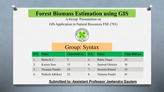
  • 1. Forest Biomass Estimation using GIS A Group Presentation on GIS Application in Natural Resources FSE (701) Group: Syntax S.N. Name Class Roll no. S.N. Name Class Roll no. 1. Binita K.C. 5 5. Rabin Thapa 25 2. Kusum Saru 15 6. Santosh Ghimire 34 3. Niranjan Paudel 19 7. Susmita Khanal 39 4. Prabesh Adhikari 22 8. Yamuna Paudel 43 Submitted to: Assistant Professor Jeetendra Gautam
  • 2. OUTLINE OF THE PRESENTATION INTRODUCTION OBJECTIVES METHODOLOGY FINDINGS AND RESULT CONCLUSION REFERENCES 1 3/21/2022
  • 3. INTRODUCTION Biomass is defined as mass of live or dead organic matter that includes the above- ground and below-ground living biomass, dead mass, and litter (GTOS, 2009). The largest carbon pool are typically stored in the above-ground living biomass. Thus estimating above-ground forest biomass (AGB) is the most important step in quantifying carbon stocks from forests (Gibbs et al., 2007). The most accurate ways of calculating biomass data is based on field measurement through destructive sampling or allometric equations method (Englhart et al., 2011). However, these methods are often cost and time consuming, labor intensive, have limited spatial distribution, and impractical especially in remote areas (Englhart et al., 2011). Remote sensing techniques have the capacity to overcome the limitations of conventional field measurement methods and have now become the primary source in estimating AGB (Lu, 2006). 2 3/21/2022
  • 4. INTRODUCTION These methods have been explored in terms of biomass and its changes to increase our understanding of the role of forests in the carbon cycle for greenhouse gas inventories and terrestrial carbon accounting (Muukkonen & Heiskanen, 2007). Although much research has explored biomass estimation using remote sensing technology methods to select suitable variables from remote sensing data and develop estimation models suitable for specific studies are still poorly understood. It is crucial to summarize the current status of remote sensing-based biomass estimation techniques and discuss potential solutions to improve biomass estimation performance. 3 3/21/2022
  • 5. OBJECTIVES General Objective: To estimate the biomass of forest using GIS. Specific Objective: To calculate above ground biomass of Milanchowk CF from field inventory. To establish a regression model between aboveground biomass and Sentinel 2 image. 4 3/21/2022
  • 6. METHODOLOGY Study Area: The study was carried out in the Milanchowk Community Forest, located in Chitlang, Makawapur District. It is extended from 27.34'52" N to 27.40'59"N and 85.01'21"E to 85.12'20"E The average annual rainfall has been recorded as 1863mm/year. The dominant species of the study area are Pinus and Quercus species. 5 3/21/2022
  • 7. METHODOLOGY Methodology Steps: 1) Download Sentinel 2 imaginary from USGS Earth Explorer. 2) Add Sentinel 2 imaginary data in Arc GIS 10.8 and calculate NDVI value. 3) Add boundary and sample plot point of CF. 4) Calculate Red band, Green bend, Blue band, NIR and NDVI value of sample point. 5) Develop equation (Biomass vs Red, Green, Blue, NIR, NDVI Value) from R-Studio programming software. 6) Validation Analysis using Paired t-test. 6 3/21/2022
  • 8. METHODOLOGY Data Collection: 7 3/21/2022 S.N. Data collection Activities 1. Primary data collection  The systematic sampling method with 10m * 10m sample plot is used for field measurement.  The biomass is estimated by using the equation: AGB = 0.0509 * pD2H (Where, AGB = above-ground tree biomass [kg]; p = wood specific gravity [g/cm3; D = tree diameter at breast height [cm]; and H = tree height [m])  Sentinel 2 image is used to calculated NDVI Value. 2. Secondary data collection  Books  Journals  Article  Reports
  • 9. FINDINGS AND RESULT 8 3/21/2022 Sample plot Biomass (kg) 1 1602 2 1429 3 1490 4 948 5 2164 6 1956 7 1253 8 572 9 1479 10 1080 11 1094 12 653 13 723 14 1814 15 1118 16 1113 17 845 18 422 19 1669 20 1847  Out of 30 sample plots, biomass estimation is done from 20 sample plots which are used to generate the biomass equation.  The maximum, minimum and average biomass estimates from 20 sample plot of Milanchowk C.F. are 2164 kg, 422 kg and 1263 kg respectively. Biomass estimation
  • 10. FINDINGS AND RESULT 9 3/21/2022 NDVI Value: The high, low and average NDVI value of Milanchowk C.F. are 0.38033, 0.23325 and 0.322 respectively.
  • 11. FINDINGS AND RESULT S.N. Red Green Blue NIR NDVI 1. 1599 1732 1823 2754 0.265334 2. 1591 1729 1829 3162 0.330528 3. 1510 1685 1796 2699 0.28249 4. 1521 1766 1807 3084 0.339414 5. 1575 1820 1837 3401 0.366961 6. 1569 1768 1824 3128 0.331914 7. 1756 1770 1861 3031 0.266346 8. 1509 1734 1803 2843 0.306526 9. 1512 1716 1806 2804 0.299351 10. 1519 1694 1796 2938 0.318376 11. 1537 1731 1811 3175 0.347623 12. 1579 1729 1813 3006 0.311232 13 1595 1724 1816 2997 0.305314 14. 1575 1715 1811 3292 0.352784 15. 1547 1742 1812 3218 0.350682 16. 1561 1739 1820 3106 0.331048 17. 1559 1741 1817 3083 0.328307 18. 1544 1756 1802 3197 0.348661 19. 1558 1727 1815 3182 0.342616 20. 1562 1746 1817 3057 0.323663 1 0 3/21/2022 The Red band value, Green band value, Blue band value, NIR value and NDVI values are tabulated as:
  • 12. FINDINGS AND RESULT Equation formulation: To develop the biomass equation, five independent variables are used i.e. (Biomass ~ Red band, Green band, Blue band, NIR, NDVI value). Linear regression equation is used to fit dependent variable with independent variables. The fit regression equation derived from biomass modelling is: Biomass ~ A + B * Red + C * Green + D * Blue + E * NIR + G * NDVI 11 3/21/2022
  • 13. FINDINGS AND RESULT The resultant data obtained from R- programme are: 12 3/21/2022 Constant Value A -7.153034e+03 B -5.855211e+01 C -8.727644e+00 D 4.992052e+01 E 2.665179e+01 G -1.767242e+05
  • 14. FINDINGS AND RESULT 13 3/21/2022 Equation Validation Analysis:  Ten sample plots are used for equation validation analysis.  The resultant p value obtained from paired t– test is p=0.08756 > 0.05, which indicates above biomass equation is valid.
  • 15. CONCLUSION The maximum, minimum and average biomass are estimated as 2164 kg, 422 kg and 1263 kg respectively. The high, low and average NDVI value are 0.38033, 0.23325 and 0.322 respectively. The best fitted regression equation derived from biomass modelling is Biomass ~ A + B * Red + C * Green + D * Blue + E * NIR + G * NDVI . The biomass equation developed from this study can be used by the relevant institutions, organizations and academics for research purposes as well as forest management authorities. 14 3/21/2022
  • 16. REFERENCES Englhart, S., Keuck, V. & Siegert, F. (2011). Aboveground biomass retrieval in tropical forest. Remote Sensing of Environment 115, pp. 1260-1271. Gibbs, H.K., Brown, S., Niles, J.O. & Foley, J.A. (2007). Monitoring and estimating tropical forest carbon stocks: making REDD a reality. Environmental Research Letters 2 (4), 13pp. GTOS (Global Terrestrial Observing System). (2009). Assessment of the status of the development of the standards for the terrestrial essential climate variables: Biomass. Report FAO. Lu, D.S. (2006). The potential and challenge of remote sensing-based biomass estimation. International Journal of Remote Sensing, 27 (7), pp. 1297-1328. Muukkonen, P. & Heiskanen, J. (2007). Biomass estimation over a large area based on standwise forest inventory data and ASTER and MODIS satellite data: A possibility to verify carbon inventories. Remote Sensing of Environment, 107(4), 617-624. 15 3/21/2022