2018-08-31 - Tony Dare-Edwards - The life and work of Bruce Butler
•Download as PPTX, PDF•
1 like•249 views

A talk given to the Riverina branch of Soil Science Australia at Mathoura on 31 Aug 2018 by Dr Tony Dare-Edwards about the life and work of Bruce Butler.

Recommended
Recommended
More Related Content
What's hot
What's hot (19)
Similar to 2018-08-31 - Tony Dare-Edwards - The life and work of Bruce Butler
Similar to 2018-08-31 - Tony Dare-Edwards - The life and work of Bruce Butler (20)
More from Riverina Branch of the Australian Society of Soil Science
More from Riverina Branch of the Australian Society of Soil Science (20)
Recently uploaded
Recently uploaded (20)
2018-08-31 - Tony Dare-Edwards - The life and work of Bruce Butler
- 1. Bruce Butler: His Role in Our Understanding of the Soils and Landscape of the Riverine Plain
- 2. Bruce Ernest Butler BSc., 1937. Agricultural Science; University of Western Australia Joined CSIR, Division of Soils, Waite Institute, 1937. RAAF Navigator 1939 - 1944
- 3. In the period immediately following the Second World War the federal Labor government moved rapidly to begin the building of the Snowy Mountains Scheme which would provide hydroelectric power to the country but equally would store and supply the water for the planned expansion of the irrigation areas in the Murrumbidgee and Murray valleys
- 4. 1946 A Hand Drawn Original: The Snowy Mountain Scheme Published by Department of Post War Reconstruction
- 5. CSIRO, in association with state bodies, was commissioned to survey and map the soil resources of the pre-exiting and planned irrigation areas. In 1945, Bruce Butler was appointed Regional Soils Officer in Deniliquin , a central location for the planned irrigation in New South Wales and Victoria He began the detailed surveys which in conjunction with the engineering work upstream laid the foundations for the modern irrigation areas of the region today.
- 6. •Australian soil science at that time in the 1940s was strongly influenced by the ideas and models developed in northern Europe and North America; landscapes where widespread glaciation and periglacial conditions have been replaced by warmer more temperate conditions only in the last 10 000 years. •Thus, many northern European soils, studied at that time, had formed only since the onset of the Holocene
- 7. Throughout the Tertiary, (beginning approximately 60 million years ago) materials stripped from the rising Eastern Highlands in the east were transported by the paleo- Murrumbidgee, -Murray, -Lachlan and -Darling rivers to be deposited in the terrestrial eastern half of the basin: the Riverine Plain. While in the western half of the Murray Basin, terrestrial deposition is associated with marine deposition – the result of several marine incursions flooding the western portion of the Murray Basin- and the formation of extensive lake deposits from Lake Bungunnia. Landscape History of the Murray-Darling Basin
- 10. •Bruce Butler was working in a landscape, which on first examination appeared to a monotonous, undifferentiated flat plain, was, in fact, very complex. •A region where rivers and lakes had existed throughout the Tertiary and on into the Quaternary (Pleistocene and Holocene). •Soil formation on the Plain had continued episodically over extended periods of time. •Bruce Butler and his teams soon found that the soil patterns they were recording required the development of new models to explain and understand their occurrence.
- 13. Bruce Butler’s work in the Riverine Plain was instrumental in developing three main advances in our understanding of soil and landscape processes in Australia: 1, Fluvial and soil deposition. Butler proposed a new model for the fluvial history of the stream channels that cross the plain through the identification of a distinctive channel morphology – his Prior Stream terminology; 2, Soil stratigraphy. Butler identified widespread palaeosols either at the surface or buried within the landscape that he resolved into his K-Cycle model of soil periodicity; and 3, Aeolian accession. Butler recognised that the plain was a depositional site of aeolian clay sediments blown in from the west that formed discreet mantles of aeolian clay – an aeolian sediment he termed Parna. (Closely associated with his identification of the Parna deposits was the recognition of a new textural class: Sub-plasticity)
- 14. In summary, He realised that the soils and landscape of the Riverine Plain were the result of a complex pattern of ongoing environmental changes that stretched back into the Pleistocene and beyond. • The formation and distribution of the surface soils could only be understood within the context of a comprehensive model of the Quaternary history of the Riverine Plain. • Butler’s work was seminal to the development of the modern discipline of Quaternary geomorphology.
- 15. Bruce Butler’s ideas were taken up first through his mentoring a group of young graduates (“Butler’s Boys”) mainly from Sydney University where they had been trained by Prof E.G. (Gordon) Hallsworth who later became the head of the CSIRO Division of Soils in the 1960s. They were either part of the NSW Dept of Agriculture’s Soil Survey Unit or the CSIRO Division of Soil and were sent to gain field experience under Bruce Butler.
- 16. “Butler’s Boys” included: Max Churchward: who joined CSIRO on graduating from Sydney in 1952 worked with Bruce Butler in the Mallee country of western NSW and Victoria. Pat Walker was initially in the NSW Dept of Agriculture but later joined CSIRO in late 1950s. His area was in the NSW tablelands and south coast John Beattie was initially with the NSW Dept of Agriculture and joined CSIRO in the late 1950s. He worked in SW Slopes NSW around the city of Wagga Wagga before leaving CSIRO for the University of Tasmania. Cedric Hawkins worked for the NSW Dept of Agriculture, Soil Survey Unit across NSW from early the 1950s until retirement in the 1980s Ray Storrier joined the NSW Soil Conservation Service in 1952 before transferring to the NSW Soil Survey Unit in 1953. He worked on surveys in the Swan Hill area and in the Sydney Basin (both surveys undertaken with Ian Little) . Ray later joined the Wagga Agricultural College Dick van Dijk, worked around Griffith (NSW), Canberra and the Albury /Wodonga areas.
- 17. Butler’s work on the Riverine Plain was influential in triggering concomitant research by staff of other government agencies such the 1, Water Conservation and Irrigation Commission (N.S.W.) where Simon Pels , Mark Stannard , Per Gunn, Ari van der Lelij ,and Warren Muirhead (to name only a few) were very active, and 2, the Victorian Geological Survey where Charlie Lawrence and Phil Macumber worked; while, 3, within the university sector, Langford-Smith, Schumm, Dury and later Jim Bowler took up Butler’s ideas and developed them.
- 20. First Use of Term : Riverine Plain, Butler 1950 •The name "Riverine", was in use as early as 1857 when long letter under the caption "Riverine Colony" appeared in the Border Post of January 24, 1857. •Dunmore Lang coined the name by translating the Spanish name of the Entre Rios province (Between Two Rivers) in Argentina, South America. • •Dunmore Lang was involved with the short lived Riverina secession movement which was active in the 1860s
- 21. THE THEORY OF PRIOR STREAMS
- 22. THE THEORY OF PRIOR STREAMS “It is postulated that: (i) The sedimentary pattern of the Riverine Plain of South- Eastern Australia was formed by a system of streams which traversed the Plain in a period prior to the present era. These are called Prior Streams. (ii) There has been negligible aggradation or erosion in the present era, and the topography of the Plain is, therefore, that formed by the prior streams. (iii) Variations in the original salinity of the sediments of the plain are related to the sedimentary pattern of the prior stream systems. (iv) The characteristics of the sedimentary pattern, the topographic pattern, and the salinity pattern of the prior stream systems are reflected in the soil pattern of the Riverine Plain”. Butler 1950
- 24. Texture GradientSalinity Decrease in Leaching
- 25. Butler 1950 1950 Prior Stream Model
- 27. Red Earth Red Brown Earth Grey Brown Red Clays Classic 1950’s Model of Soil Pattern associated with Prior Stream
- 28. Change from Grey Soil of Heavy Texture to Red Soil of Heavy Texture
- 29. Palaeochannel The Rock Channel Bed Sands and gravel. Levee soil
- 32. Field Trip 1974 Bruce Butler digging in the levee of a prior stream while Jim Bowler looks on. N.B. Classic 1970s Public Servant Clothing Style Crimplene shorts and long, white/grey nylon socks
- 33. Out on the Plain comparing Butler’s maps with the landscape What Prior Stream?
- 35. Bundure Quarry
- 36. Soil Stratigraphy: Butler’s recognition of sequences of soils stacked on top of each other.
- 37. Bruce Butler: Groundsurfaces and K-Cycle Model • Butler identified sequences of buried soils across the Riverine Plain. • The soils of the Plain are NOT formed as a single soil formation episode but are the result of a mixture of either continuous, long term exposure; partial burial; or complete burial. • The soils at the surface have a very complex pattern of varying age, and soil history. • Butler identified a cycle of events – a K-Cycle. Each cycle consists of a pulse of erosion and/or deposition (in an arid period i.e. glacial times) followed by a period of landscape stability and soil formation (i.e, humid period, interglacial times. •The soils of each K-cycle all form part of the same Groundsurface •Soils/sediments of each Cycle are given a number starting from K1 as the youngest cycle and numbering consecutively back through time: K1, K2, K3, K4 • The erosion/deposition phase of the K Cycle is termed Ku ; the soil formation phase is termed Ks: hence K1u K1s ; K2u K2s ;
- 38. Butler , B.E. 1959. Periodic Phenomena in Landscapes as a Basis for Soil Studies K3 K3 K2 K2 K1 K1
- 41. Ku Ks Ku Ku Ku Ku Ks Ks Glacial ? Glacial ? Glacial ? Interglacial? Interglacial? Interglacial?
- 42. Butler’s Model of Formation of Riverine Plain: Soil and Landscape Sequence
- 43. Butler’s Classic Diagram A Cross Section of Riverine Plain: Sequences of Fluvial and Aeolian Sedimentation
- 45. •Bruce Butler working in the Riverine Plain identified sheets of clay that he could trace across the landscape; •The sheets draped hill slopes and ridge crests; •He realised that the only mechanism that could have deposited these sheets must be wind deposition; •He predicted that the aeolian clay had been deflated from soil- and desert- surfaces to the west : the Mallee and arid Central Australia and blown eastwards to be deposited across the Riverine Plain Aeolian Clay Sheets of the Riverine Plain
- 46. •At that time the scientific literature describing wind blown deposits used the term Loess. •Loess was a defined as “silt-sized” mineral grains(not clay-size) deflated from glacial deposits and transported on to the surrounding landscapes. •There was no accepted term at that time for wind blown sediments deflated from “hot deserts”. •Butler decided to generate a new term, using a word from a South Australian Indigenous language: Parna: “A dry and dusty ground” What’s in a Name? Everything it appears!
- 47. It differs from loess in its particle size grading , being characteristically more more clayey, while the mode of particle size of the non-clay fraction is coarser, its size varying between 40µm and 160 µm •An earthy, homogeneous, calcareous (Probably saline too) substance without stratification; •It occurs as extensive, nearly uniform, sheets which mantle the landscape covering both higher and lower elements. •Forms both sheets and dunes in the landscape. • Travels as clay aggregates. • Size of clay aggregates can be reconstructed from size of “companion sand”, the mineral grains that travelled with the clay aggregates PARNA : 1956 Definition “It is proposed that the term ‘Parna‘ should refer to the material that was deposited as clay aggregates in the form of sheet or dunes”
- 48. Formation of Lunettes : Stephens and Crocker, 1946, quoting Hills 1940. Clay dust is not usually, and certainly not entirely composed of ultimate particlesbut of aggregates. A certain size range of aggregates would behave like sandgrains in being transported by saltation and surface drift---especially over a limited distance. In this way, silt and clay particles from the lagoon or swampbed could readily contribute towards the building of a lunette. They are ''clay pellets". Clay Pellets/Clay aggregates already identified in Australia
- 51. Butler, 1956 Parna an Aeolian Clay No Vegetation in this zone during the period of deposition meant that no parna was trapped as it moved from west to east across the Riverine Plain Butler (per. comm. 1976) says that this zone does not exist but is the result of the difficulty of identifying parna from fluvial clay deposits in the west of the Plain.
- 54. Criticism of Prior Stream Terminology 1.Simon Pels 2.Jim Bowler 3.Ken Page and Gerald Nanson
- 55. Introduction of the Term: Ancestral Rivers Simon Pels working from Deniliquin identified a distinctive form of river channel that post–dated the Prior Streams of Bruce Butler Sinuous, suspended load channels that were incised into the fluvial landscape
- 56. Prior Stream Ancestral River Simon Pels: Prior Streams, Ancestral Rivers and Modern River
- 57. Page, 1996
- 58. Simon Pels’ Map of the three phases of his Ancestral Rivers (The Coonambidgal) crossing the Mallee Landscape
- 59. Simon Pels’ Diagram of the Edward River at Deniliquin
- 61. 1, Introduction of the term : Complex. Bowler identified problems between Pels' use of the term Coonambidgal and Butler's (1958) definition. Bowler proposed local geographic names such as Tallygaroopna (Coonambidgal 1) and Kotupna (Coonambidgal 2) to identify the different phases of stream activity in the lower Goulburn Valley. 2, More importantly, Bowler questioned the classification of ancient channels into two exclusive types: Prior and Ancestral. 3, He noted that both types sometimes occur in different reaches of the same channel, as for example, along Green Gully on the Cadell Block. In addition, he noted that many of the ancestral channels carried appreciable quantities of sand and gravel and in this respect resembled prior streams. 4, Bowler concluded that Pels' separation of ancestral rivers into a genetically different category from that of the supposedly earlier prior streams was unwarranted. Entry of Jim Bowler into the Discussion
- 62. Jim Bowler’s introduction of the term: Complex Green Gully changes from Unconfined to Confined
- 63. 1973 Geomorphic Map of the Riverine Plain B. E. Butler, G. Blackburn, J. M. Bowler, C. R. Lawrence, J. W. Newell, S. Pels
- 64. 1973 Geomorphic Map of the Riverine Plain B. E. Butler, G. Blackburn, J. M. Bowler, C. R. Lawrence, J. W. Newell, S. Pels
- 65. Entry of Ken Page and Gerald Nanson Page and Nanson (1996) made extensive use of the bore log data sets collected by the Water Conservation and Irrigation Commission for the Coleambally and Darlington Point areas.
- 66. WCIC data in conjunction with additional field work and thermoluminescence dating. supported the contention of Bowler (1978) that the sequential model for palaeochannel evolution from bedload Prior Stream to suspended-load Ancestral River of Pels could no longer besustained. Page and Nanson (1996) proposed a new, chronologically calibrated, stratigraphic model of palaeochannels oscillating between laterally migrating mixed-load and aggrading low sinuosity bedload modes.
- 67. Page and Nanson Model
- 68. The Butler/Pels’ model of palaeochannel evolution where early bedload dominated Prior Streams were replaced by suspended load ancestral rivers is wrong. In fact, the Prior Streams- Ancestral Rivers sequence is in the wrong order. The Page/Nanson Model for the period 100 ka to 12 ka states that an initial mixed-load phase terminates with channel aggradation and the formation of typical Prior Stream characters.
- 69. The sequence is: 1. The development of laterally active, sinuous, mixed-load channels. 2. A shift to bedload dominated aggrading channels as a result of a change in the ratio of sediment to water delivered from the headwater region. 3. Vertical accretion, reduced sinuosity, increased depth, narrower channels, and the development of levees. 4. Channel avulsion and eventually the establishment of a new mixed-load system elsewhere on the Plain. 5. The original channel is buried in a blanket of fines including wind blown sediments.
- 70. Yanco 13Ka to 20 ka Coleambally 80 – 105 ka Kerarbury 35ka to 55 ka Gum Creek 25ka to 35 ka Page and Nanson’s Palaeochannel Map Page and Nanson identified four distinct phases of palaeochannel activity that were associated with substantially larger bankfull discharges than the present river system
- 72. • Coleambally and Kerarbury Phases In the Late Quaternary, these phases of the Murrumbidgee region were characterized by alternating episodes of laterally migrating mixed-load and vertically aggrading bed load dominated channel activity with the Coleambally and Kerarbury phases both ending with the classic bedload-dominated episode, with its reduced sinuosity and the formation of levees. •Gum Creek Some lower reaches of the Gum Creek Phase also display a vertically aggrading bed load in their final stages. •Yanco The final phase was characterized by migrational palaeochannels that carried large volumes of sand but did not terminate in an episode of channel aggradation. Holocene Rivers The diminished size of peak floods and dramatically reduced supply of coarse bedload sediment accompanying Holocene climate change resulted in the establishment of the highly sinuous, slowly migrating, suspended-load rivers of the present system. Page and Nanson’s Four Phases
- 74. Scaled Stratigraphic Model of Riverine Deposits beneath Coleambally I.A. (K. Pucillo, 2005)
- 75. Criticism of K Cycle Model 1, The combination of an erosion/depositional, K U phase with a period of soil formation, KS It is a complex time-rock unit. 2, The problem of correlation of K Cycles across a local landscape and/or between regions. No absolute dating available. So, use soil characters and position in the sequence as guides 3, The use of the term “Groundsurface” could be confused with a term in common usage. 4, Did not fit with contemporary geological terminology. Soil stratigraphy was in its infancy.
- 76. TL date 100 ka Yarabee K2 Source Bordering Dune Beattie correlates Yarabee with Widgelli parna
- 78. John Beattie’s 1972 Tentative Correlation of Groundsurfaces across the Landscape
- 80. Kyeamba 0 to 10ka Holocene Yarabee 10 to ~100ka Complex polygenetic soil profile with at least three welded soils. Brucedale 100 to ~200ka Complex polygenetic soil profile with abundant soil carbonate Willis 200 to 790++ ka Complex with classic Parna sediments (Equivalent to Blanchetown Clay) KAROONDA WEATHERING SURFACE Upper Marinna Early Pleistocene to Pliocene ~ 790 to 2.8Ma (Equivalent to Calivil Formation/Parilla Sand) MOLOGA WEATHERING SURFACE Lower Marinna Late Miocene 2.8 -10Ma+ Proposed Absolute Chronology Wagga Wagga Groundsurfaces Widgelli Katandra
- 82. Wagga Wagga Brickpit; Gone but not Forgotten
- 83. Development of the Pedoderm Brewer et al . 1970 ‘a mappable unit mantle of soil, entire or partially truncated, at the earth’s surface or partially or wholly buried, which has physical characteristics and stratigraphic relationships that permit its consistent recognition and mapping’. Each pedoderm is given a geographic name 1, A pedoderm represents a period in the history of erosion and sedimentation during which soil formation took place. 2, Although a pedoderm may be formed in rocks of varying ages, it is assigned a stratigraphic position on top of the youngest rock which it overlies. 3, Each pedoderm can be subdivided stratigraphically into horizons but, contrary to the practice in rock stratigraphy, if these horizons are genetically related to the constituent soil profile, they cannot be later elevated to the status of a pedoderm.
- 84. The alternative meaning of pedoderm and its use for soil surface characterization M.V. Fey, A.J. Mills , D.H. Yaalon Geoderma 2006 It is defined here as the thin layer of soil at the interface with the atmosphere, a few millimetres to centimetres thick, within which certain properties may exhibit a marked vertical change in expression sometimes not readily detected through field observation.
- 85. What’s in a Name? The Problem (?) of “Parna” •“Despite more than 50 years of recognition of loess-like deposits in Australia, this area of research has not yet reached the stage where even some of the basic physical properties of the dust are known with certainty or where long-term (millennial) rates of dust deposition are known from onshore sites. •Terminology: Parna, aeolian clay, dust mantle, loessic clay or clay loess? •A kind of folklore has grown up around the Australian ‘parna’ deposits. One of Butler’s (1956) original deductions was that the clay must be present, originally, as clay pellets to account for its rapid settling in conformity with the companion quartz silt grains. •Butler did not see these clay aggregates in the original samples and stated that they would quickly break down after deposition”. Quote from : Paul Hesse and David Haberlah
- 86. “Dune Parna” Willandra Lakes Dune System Parna overlies Ordovician Metasediments, South of Narrandera Parna travels as clay aggregates Size of aggregates similar to “companion sand” 250 µm
- 87. Classic Model of Parna Sediment Sources, Transportation and Deposition Source: Stephen Cattle
- 88. Bowler’s Classic Model: Parna production through the Pleistocene
- 92. 2014, Mineral Dust A Key Player in the Earth System Eds. Peter Knippertz & Jan- Berend W. Stuut Map of Australia showing the approximate areas with widespread fine grained loess(parna) deposits (Hesse and McTainsh (2003)).
- 93. Dry lake beds as sources of dust in Australia during the Late Quaternary: A volumetric approach based on lake bed and deflated dune volumes. Will Farebrother, Paul P. Hesse , Hsing-Chung Chang , Claudia Jones Quaternary Science Reviews 161 (2017) 81-98 The study explored the relative volumetric importance of ephemeral lakes that emit dust to the Australian south-eastern dust path over the last glacial cycle. SRTM DEMs and GIS analyses of long-term (up to 80 ka) lake-bed deflation volumes and deposition of sand-sized sediment onto downwind source bordering dunes were used to derive estimates of transported dust mass. The results imply that the ephemeral lakes (playas) are Not the main source of aeolian sediments but that there are significant additional sources of dust in Australia over these timescales, from floodplains, dune fields. (and exposed soil surfaces? -as predicted by Butler)
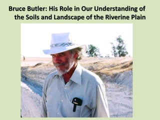
- 94. Bruce Butler at Picnic Point