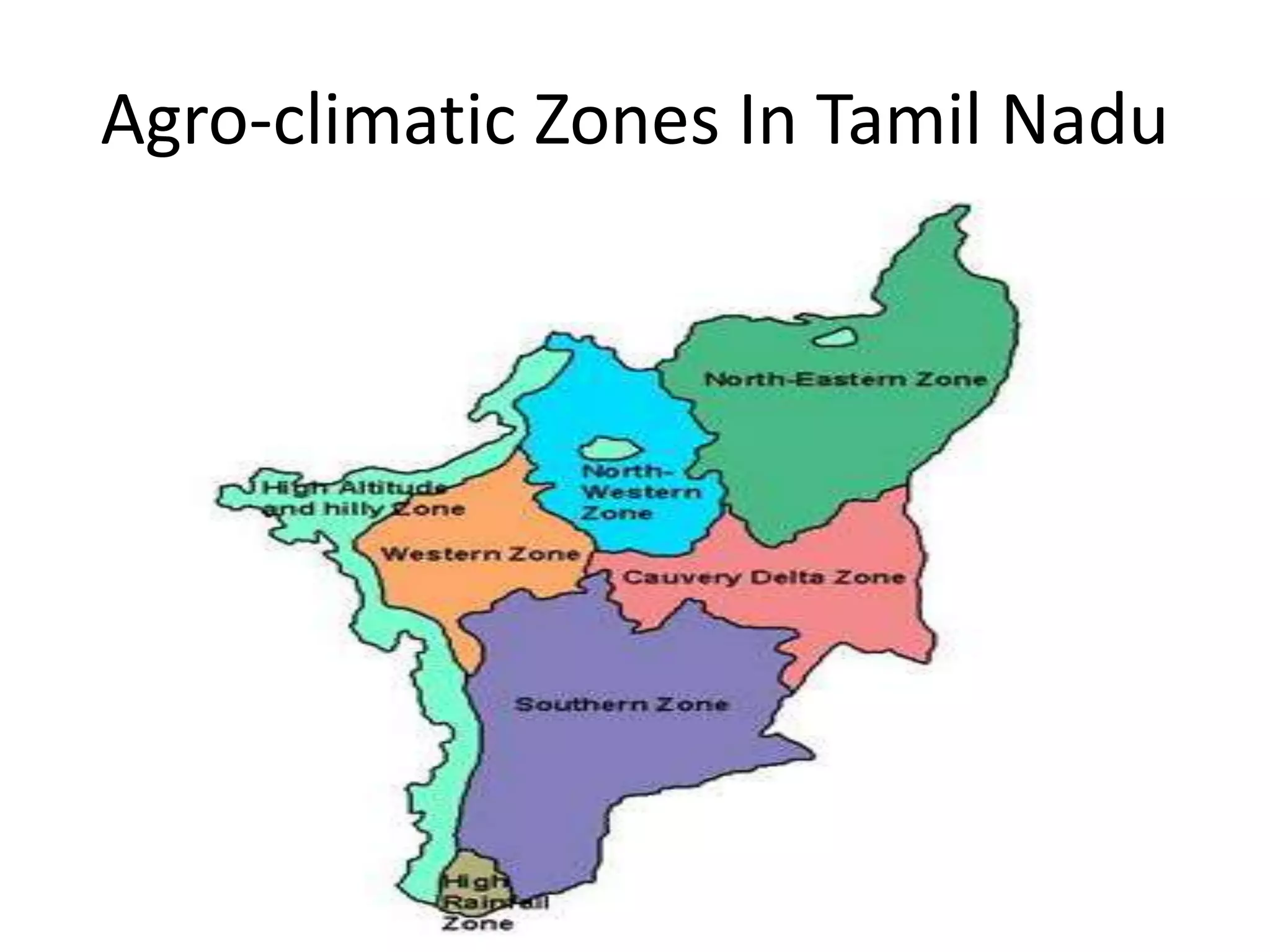
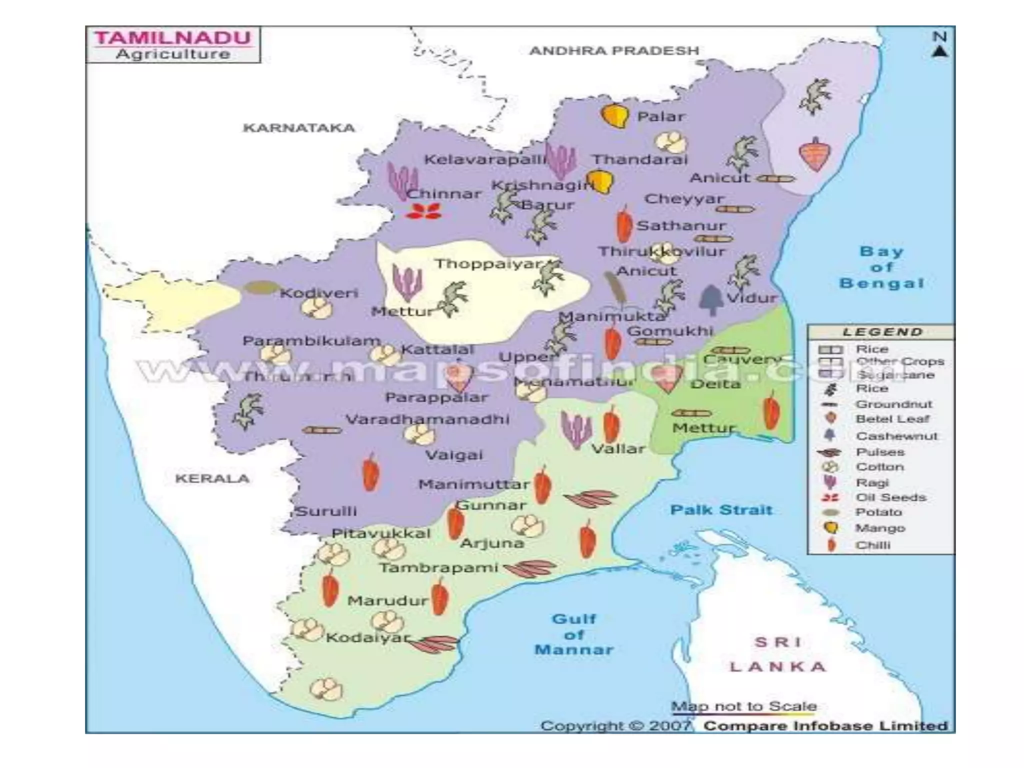
The document discusses the seven distinct agro-climatic zones of Tamil Nadu: 1) North Eastern zone, 2) North Western zone, 3) Western zone, 4) Cauvery Delta zone, 5) Southern zone, 6) High Rainfall zone, 7) Hilly zone. Each zone is defined based on its geographical location, climate patterns like rainfall and temperature, soil types, and included districts. The zones vary in their climatic conditions like average rainfall, temperature ranges, and types of crops suitable for each region.
Introduction to the agricultural geography of Tamil Nadu, presented by Pavithra Senthilkumar from MK University.
Tamil Nadu is divided into seven agro-climatic zones: North Eastern, North Western, Western, Cauvery Delta, Southern, High Rainfall, and Hilly.
Lists the agro-climatic zones and their corresponding districts and soil types, providing a framework for the state’s agricultural landscape.
Features of the North Eastern zone including districts covered, rainfall (1054 mm), temperature range (19.5 to 38.9 °C), and influence from both monsoons.
Description of North Western zone, encompassing Dharmapuri and Krishnagiri with lower rainfall (825 mm) and dry climate impacts.
Overview of the Western zone's coverage, mean annual rainfall (718 mm), and temperature variations across months.
Cauvery Delta zone's areas, highlighting its mean annual rainfall (1078 mm) during various seasons, emphasizing monsoon influences.
Largest zone in Tamil Nadu facing drought due to rain shadow effects; describes climate, rainfall (776 mm), and temperature ranges.
Focused on Kanyakumari district with high rainfall (1469 mm) and unique climatic conditions differing from other zones.
Describes the Hilly zone with varied rainfall from 850 mm to 4500 mm, highlighting the diversity in topography and climate.
Consolidation of the Agro-climatic zones in Tamil Nadu, summarizing the information discussed throughout the presentation.
The state ofTamil Nadu has been classified
into seven distinct agro-climatic zones
listed below.
• 1. North Eastern zone
• 2. North Western zone
• 3. Western zone
• 4. Cauvery Delta zone
• 5. Southern zone
• 6. High Rainfall zone
• 7. Hilly zone
3.
S.No Agro ClimaticZones Districts Covered Soil Type
1 North Eastern Zone Kancheepuram, Tiruvallur, Cuddalore, Vellore,
Villupuram and Tirunvannamalai
1. Red Sandy Loam 2. Clay
Loam 3. Saline coastal
Alluvium
2 North Western Zone Dharmapuri, Krishnagiri, salem and Namakkal
(Part)
1. Non Calcareous Red 2.
Non Calcareous Brown 3.
Calcareous Black
3 Western Zone Erode, Coimbatore, Tiruppur, Theni, Karur (part),
Namakkal (part), Dindigul, Perambalur and
Ariyalur (part)
1. Red Loamy 2. Black
4 Cauvery Delta Zone Thanjavur, Nagapattinam, Tiruvarur, Trichy and
parts of - Karur, Ariyalur, Pudukkottai and
Cuddalore
1. Red Loamy 2.Alluvium
4.
5 Southern ZoneMadurai, Sivagangai,
Ramanathapuram,
Virudhunagar, Tirunelveli
and Thoothukudi
1. Coastal Alluvium 2.
Black 3. Red Sandy soil
4. Deep red soil
6 High Rainfall Zone Kanyakumari 1. Saline Coastal 2.
Alluvium 3. Deep Red
Loam
7 Hilly Zone The Nilgiris and
Kodaikanal (Dindigul)
Lateritic
5.
1. North Easternzone
• This zone covers the districts of Thiruvallur,
Vellore, Kanchipuram, Thiruvannamalai,
Viluppuram, Cuddalore (excluding Chidambaram
and Kattumannarkoil taluks), some parts of
Perambalur including Ariyalur taluks and also
Chennai.
• The mean annual rainfall of this region is 1054
mm received in 53 rainy days and is benefited by
both the monsoons.
• The mean monthly maximum temperature ranges
between 28.2 to 38.9 °C and the minimum ranges
from 19.5 to 24.8°C.
6.
2. North Westernzone
• This zone comprises of Dharmapuri and
Krishnagiri district (excluding hilly areas),
Salem, Namakkal district (excluding
Tiruchengode taluk) and Perambalur
taluk of Perambulur district.
• The climate prevailing in this region is dry
and sub humid. This region has been
identified as moderately drought prone
area.
7.
The elevation variesfrom 330 to 1070 m above
mean sea level.
The mean annual rainfall of this region is
appreciably lower than in North Eastern zone and is 825
mm received in 47 rainy days.
The region is benefited by both south-west and
north-east monsoon rains but unlike the NEZ, the former
contributed more to the total rainfall.
The mean monthly maximum temperature ranges
between 30 to 37°C with minimum temperature ranging
between 19 to 25.5°C.
The annual PET of this region is 1727 mm
compared to the annual precipitation of 825 mm.
8.
3. Western zone
•This zone comprises of Erode, Coimbatore, Dindigal,
Theni districts, Tiruchengode taluk of Namakkal
district, Karur taluk of Karur district and some
western part of Madurai district.
• The mean annual rainfall is 718 mm in 45 rainy days.
The monthly mean maximum temperature is 35°C in
April and 30°C in January and November.
• The monthly mean minimum temperature is 19°C in
January and 24°C in May.
9.
4. Cauvery Deltazone
• This zone comprises the Cauvery Delta area in
Thanjavur, Thiruvarur, Nagapattinam districts and
Musiri, Tiruchirapalli, Lalgudi, Thuraiyur and
Kulithalai taluks of Tiruchirapalli district, Aranthangi
taluk of Pudukottai district and Chidambaram and
Kattumannarkoil taluks of Cuddalore district.
• The mean annual rainfall of the zone is 1078 mm out
of which 40mm is received during winter, 69.2mm
during summer, 295.4mm during South West
Monsoon and 673.8mm during North East Monsoon.
10.
5 .Southern zone
•This is the biggest among the seven zones of Tamil
Nadu. It is typical zone surrounded by coastal areas
on the East and mountains in the West.
• This zone comprises Sivagangai, Ramanathapuram,
Virudunagar, Tuticorin and Tirunelveli districts and
Natham and Dindigul taluks of Dindigul district,
Melur, Tirumangalam, Madurai South and Madurai
North taluks of Madurai district and Pudukkottai
district excluding Aranthangi taluk.
• This zone lies on the Southern part of the State
under rain shadow area. Because of this, the area is
prone to drought very often. The climate is semi-arid
tropics.
11.
The elevation variesfrom mean sea
level to 300 m. The mean annual rainfall is
776 mm received in 43 rainy days.
The monthly mean maximum
temperature in this region ranges from
28.5°C in December to 38.5°C in June.
The monthly mean minimum
temperature varies from 21.0°C in January to
27.5°C in June.
12.
6. High rainfallzone
• This zone consists of Kanayakumari district.
This district situated in the southern most part
of the Peninsular India, with its high rainfall
having a climate which is entirely different
from the rest of the state.
• The climate is monsoon tropics and there is
seasonal in shores flow of moist air.
• The elevation ranges from sea level to about
600 m.
13.
The mean annualrainfall of the district
is 1469 mm received in 64 rainy days.
There is not much fluctuation in the
mean monthly air temperature.
The monthly mean maximum
temperature varies from 28.0°C in December
to 33.5°C in May.
The monthly mean minimum
temperature varies from 22°C in December
to 26.5°C in May.
14.
7. High altitudeand Hilly zone
• This zone comprises the hilly regions,
namely the Nilgiris, Shevroys, Elagiri-
Javvadhu, Kollimalai, Patchaimalai,
Anamalais, Palanis and Podhigaimalais.
• The rainfall varies from 850 mm in
Kalrayan hills to about 4500 mm in
Anamalai hills.