1. Mrs. Todd 5 th Grade Class Rappahannock Elementary School
2.
3.
4.
5.
6. The Great Plains Located west of the Interior Lowlands and east of the Rocky Mountains Flat land that gradually increases in elevation westward Grasslands http://www.stephentrimble.net/gp/closeup.asp
7.
8.
9.
Editor's Notes
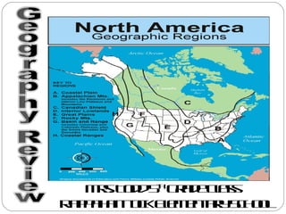
Today students we are going to go over the eight North America Geographic Regions. This is your review for the test at the end of the week.
Lets begin with the Coastal Plain which is located along with Atlantic Ocean and the Gulf of Mexico, look at the picture you will see the Coastal Plain in the yellow. The Coastal Plain has many broad lowlands which provides many excellent harbors.
The next set of regions is the Appalachian Mountains, this is west of the Coastal Plain we just reviewed. We leave in this region of the US. Our region extends from Eastern Canada to western Alabama, there are many old and eroded mountains. This is the oldest Mountain Range in North America. We should all be proud to liver here.
The Canadian Shield is at the northern edge of the US. It is wrapped around the Hudson Bay in a horseshoe shape as you see above.
The interior Lowlands is located west of the Appalachian Mountains we talked about earlier and east of the Great Plans. It is many rolling flat lands that contains many rivers, and grassy hills.
The interior Lowlands is located west of the Appalachian Mountains we talked about earlier and east of the Great Plans. It is many rolling flat lands that contains many rivers, and grassy hills.
The Rocky Mountains are the checker-boarded shaded area. As you can see they are located to the west of the Great Plains and east of the Basin and Range. The consist of Rugged Mountains that stretch from Alaska to Mexico. There are many high elevations located in the Rocky Mountains, it contains the Continental Divide, which is determined the directional flow if rivers.
Now to the Basin & Range which is located west of the Rocky Mountains and east of Nevada. It is orange on the map on the above left. This area has many varying in elevations containing isolated mountain ranges and Death Valley which is the lowest point in North America. The Death Valley is the red dot above on the map on the right.
The last regions for us to review is the Coastal Range, which is green on the map above. It is many rugged mountains along the Pacific Coast that stretches from California to Canada. In the Coastal Rang it contains fertile valleys.
![The Coastal Plain ,[object Object],[object Object]](data:image/gif;base64,R0lGODlhAQABAIAAAAAAAP///yH5BAEAAAAALAAAAAABAAEAAAIBRAA7)