
Recommended
Recommended
More Related Content
What's hot
What's hot (20)
Similar to Water Quality Assessment of VIT University “Green” Lake Using GIS
Similar to Water Quality Assessment of VIT University “Green” Lake Using GIS (20)
Recently uploaded
Recently uploaded (20)
Water Quality Assessment of VIT University “Green” Lake Using GIS
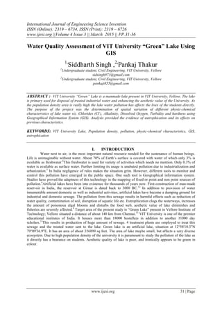
- 1. International Journal of Engineering Science Invention ISSN (Online): 2319 – 6734, ISSN (Print): 2319 – 6726 www.ijesi.org ||Volume 4 Issue 3 || March 2015 || PP.31-36 www.ijesi.org 31 | Page Water Quality Assessment of VIT University “Green” Lake Using GIS 1, Siddharth Singh ,2, Pankaj Thakur1 Undergraduate student, Civil Engineering, VIT University, Vellore sidsingh973@gmail.com 2 Undergraduate student, Civil Engineering, VIT University, Vellore pankajt855@gmail.com ABSTRACT : VIT University “Green” Lake is a manmade lake present in VIT University, Vellore. The lake is primary used for disposal of treated industrial water and enhancing the aesthetic value of the University. As the population density area is really high the lake water pollution has affects the lives of the students directly. The purpose of the project was the determination of spatial variation of different physic-chemical characteristics of lake water viz. Chlorides (Cl- ), Alkalinity, Dissolved Oxygen, Turbidity and hardness using Geographical Information System (GIS). Analysis provided the evidence of eutrophication and its effects on previous characteristics. KEYWORDS: VIT University Lake, Population density, pollution, physic-chemical characteristics, GIS, eutrophication I. INTRODUCTION Water next to air, is the most important natural resource needed for the sustenance of human beings. Life is unimaginable without water. About 70% of Earth‟s surface is covered with water of which only 3% is available as freshwater.8 This freshwater is used for variety of activities which needs no mention. Only 0.3% of water is available as surface water. Further limiting its usage is unabated pollution due to industrialization and urbanization.5 In India negligence of rules makes the situation grim. However, different tools to monitor and control this pollution have emerged in the public space. One such tool is Geographical information system. Studies have proved the adeptness of this technology in the mapping of fixed or point and non point sources of pollution.4 Artificial lakes have been into existence for thousands of years now. First construction of man-made reservoir in India, the reservoir at Girnar is dated back to 3000 BC.12 In addition to provision of water innumerable amount domestic as well as industrial activities, artificial lakes have become a dumping ground for industrial and domestic sewage. The pollution from this sewage results in harmful effects such as reduction of water quality, contamination of soil, disruption of aquatic life etc. Eutrophication clogs the waterways, increases the amount of poisonous algal blooms and disturbs the food web, aesthetic value of lake diminishes and fisheries are severely affected.9 Target area of the present study is “Green Lake” present in Vellore Institute of Technology; Vellore situated a distance of about 140 km from Chennai.13 VIT University is one of the premier educational institutes of India. It houses more than 18000 hostellers in addition to another 11000 day scholars.13 This results in production of huge amount of sewage. 4 treatment plants are employed to treat this sewage and the treated water sent to the lake. Green lake is an artificial lake, situation at 12°58'10.3"N 79°09'36.9"E. It has an area of about 356899 sq feet. The area of lake maybe small, but affects a very diverse ecosystem. Due to high population density of the university it is paramount to study the pollution of the lake as it directly has a bearance on students. Aesthetic quality of lake is poor, and ironically appears to be green in colour.
- 2. Water Quality Assessment Of Vit University... www.ijesi.org 32 | Page Figure 1: Satellite View of VIT University i.e. Green Lake II. METHODOLOGY A.)Sampling The samples were collected with help of gardeners provided by the VIT University during the months from August 2014 to November 2014.Photos of the site were captured to pin point the site on the map. Samples were stored in sterilized bottles carefully and preservation was done according to APHA standards.1 Water from deeper places was collected using a plastic tumbler attached to a stick. A total of 20 samples, about 500 ml in each bottle were collected for analysis. DO analysis experiments were performed on the site and hence instruments were taken to the lake itself. It is to be noted that only surface water was collected at deeper and shallow places to ensure uniformity in the readings. Figure 2 illustrates the site from where the samples were collected. Spots in red colour were the point sources or the source of effluents. Table 1 Showing Dates of Sample Collection Figure 2 Different sites chosen for sample collection B.)Measurement of Quality Indices Various physic-chemical characteristics namely pH, turbidity, chlorides, alkalinity, acidity, dissolved oxygen, temporary and permanent samples were analyzed and the results were noted down. Due to some constraints every test was not possible for all the 20 samples, but minimum of 5 samples were analyzed for determination of each parameter. Standard procedure according to APHA-2005 was followed .1 C.)Quality Mapping ID DATE Sample 1 19 Aug, 2014 Sample 2 12 Sep, 2014 Sample 3 14 Oct, 2014 Sample 4 5 Nov, 2014
- 3. Water Quality Assessment Of Vit University... www.ijesi.org 33 | Page Characteristic contour mapping using GIS ArcGIS 10.1 was used for mapping purpose. Image obtained from Google Earth was added as a layer and was georeferenced. Boundary of the lake was digitized in a shapefile (.shP). Similarly, another shapefile containing point feature was created to locate different sites and classifying various physic-chemical characteristics of water accordingly. Wherever the value of a parameter was not analyzed, „null‟ value was stored by default. Spatial analysis toolbar was activated and spline with barrier technique was used data interpolation. It produces the result by using a mathematical equation which minimizes the total surface curvature. The method was favoured against kringing and IDW.3 Though kringing is used to precisely determine the spatial variability but since the points were less in number and we wanted smooth surface covering the whole lake, hence spline with shape file of the sample and lake polygon as a barrier was used.3 Results were obtained according to the z values i.e. value of different parameters such as pH, turbidity etc. Map layouts were prepared and exported to .jpeg format. III. RESULTS Following results were obtained for different parameters. As mentioned above all the parameter couldn‟t be analyzed for all the samples but utmost care was taken during the experiments to achieve the most realistic results as possible. A.)Visual Analysis Lake was divided into zones and analyzed visually. The water near the outlets was relatively clear than the water far away from the outlets. The biggest outlet at the northernmost point of the lake was the clearest due to running water. Stagnant water on the sides or in the southern east corner was covered by phytoplankton. B.)pH pH was one of the two parameters to be analyzed on each sample during the span of four months. Figure 3 Showing Spatial Variation Of pH Figure 3 confirms that the pH is highest at the two bottom corners of the lake while decreasing slightly as we move towards the middle and then increasing again. After comparing figure 2 and figure 3 it was inferred that as we are closer to the point source the ph is slightly lesser as compared to the corners and increases again in the middle. C.) Turbidity Turbidity was another parameter to be analyzed for all the samples during the span of our months. Result is shown in figure 4. Figure 4 Showing Spatial Variation of Turbidity
- 4. Water Quality Assessment Of Vit University... www.ijesi.org 34 | Page After examining the figure 4 visually it can be easily said that with the exception of one or two points, turbidity in the lake is lesser in the sides as compared to middle. D.)Dissolved Oxygen Dissolved Oxygen was identified in the lake site for accurate results. After abnormal results the results were verified in the laboratory and same results were obtained. Figure 5 Showing Spatial Variation of Dissolved Oxygen (mg/l) Values higher than expectations were obtained. Hence, commenting on the parameter was impractical. E.)Chlorides 6 samples were analyzed for the determination of spatial variation of chlorides (figure 6). Figure 6 Showing Spatial Variation of Chlorides (mg/l) From the above figure it was apparent that amount of chlorides or Cl- ions is lesser in the sides and increases smoothly towards the middle. F.)Alkalinity Experiment for the determination of alkalinity was performed on 10 samples. Hydroxide (OH- ), Carbonate (CO3 2- ) and Bicarbonate (HCO3 - ) ions were estimated. Results for bicarbonate and carbonate ions were stored in two raster images while hydroxide was left out due to virtually negligible values.
- 5. Water Quality Assessment Of Vit University... www.ijesi.org 35 | Page Figure 7 Showing Spatial Variation of Bicarbonates (mg/l) Figure 8 Showing Spatial Variation of Carbonates (mg/l) After visual representation of figure 7 it was concluded that bicarbonate concentration near the treated wastewater outlets was higher than the concentration everywhere else. Same cannot be said for carbonates though. With the exception of bottom right corner, the concentration of carbonates was lower near the side boundaries and higher in the middle. Interestingly no hydroxides were found during the studies. Missing spaces in the map of carbonates suggests carbonates were absent in the area. G.)Hardness Temporary hardness was tested at first on the samples and the results were noted. Same samples were boiled and temporary hardness was removed to check for permanent hardness. spline interpolation method was used with lake polygon as a barrier for obtaining spatial variation map of temporary (figure 9) and permanent hardness (figure 10). Figure 9 Showing Spatial Variation of Temporary Hardness Figure 10 Showing Spatial Variation of Permanent Hardness Analysis of figure 9 shows temporary hardness keeps on increasing from left to right i.e. away from the treated water outlet. Permanent hardness decreased from right to left i.e. away from the point sources. IV. DISCUSSIONS Increase in the pH from left to right, or candidly, from running water due to the influents from the outlet to the relatively stagnant water may correspond to decrease in dissolved carbon dioxide in water. This deficiency may be caused to increase in the algae which take up the dissolved CO2 from water.11 As observed from figure 4, turbidity is highest at the mouth of biggest outlet and relatively lower everywhere else. This may be due to the discharged waste materials and other particles.5 It should be noted that no discharge from the outlet no. 3 was encountered during the four months of experiment. The peak concentration of chlorides was observed near the primary outlet. One of the possible reasons is the water softener present in treated sewage water.12 Other biological wastes, solid wastes are some of the dominant source as well. Increase in the concentration of chlorides may lead to disruption of marine life, fisheries and cause irregularities in the lake ecosystem. Infiltration of chlorides may severely affect groundwater quality and consequently the drinking water quality.12 Most vulnerable are the hostellers of VIT University who are exclusively dependent on the water from bore
- 6. Water Quality Assessment Of Vit University... www.ijesi.org 36 | Page wells. As concentration of carbonates show similar spatial variation as pH in the outlet side of the lake it can be easily concluded pH is greatly affected by the carbonates. Bicarbonates doesn‟t increase the pH and hence, can‟t be correlated with pH.2 As hardness points towards eutrophication the high value of permanent hardness combines i.e. Total hardness provides the evidence for colonies of phytoplankton in the lake.2 High permanent hardness at the left side and middle of the lake shows the presence high concentrations of sulphate salts of magnesium and calcium in the influents. V. CONCLUSIONS The following conclusions for the water quality of VIT University Lake can be drawn from the previous discussions. [1]. Visual appearance and presence of hardness in the lake are evidence enough to show eutrophication in the lake. [2]. The pH on the wastewater outlet side of the lake is affected by the carbonates and by eutrophication in stagnant water. [3]. Smooth chloride curve accounts for presence of softeners treated wastewater [4]. High value of total hardness shows high concentration of sulphates in lake water [5]. High turbidity shows presence of solids in the lake REFERENCES [1]. APHA, AWWA and WEF, “Standard methods for the examination of water and wastewater”, (21st edition, Washington D.C., American Public Health Association, 2005) [2]. Byron Show, Christine Mechenich and Lowell Klessig (2004), Understanding Lake Data, Wisconsin:University of Wisconsin Extension [3]. Colin Childs(2004), Interpolating Surfaces in ArcGIS Spatial Analyst, ESRI Education Services, Pg 32-35 [4]. D.L. Corwin and R.J. Wagnet(1996), Applications of GIS to the Modelling of Nonpoint Source in the Vadose Zone: A Conference Overview, Journal of Environmental Quality,pp:403-411 [5]. EPA Guidance Manuals(1999), Turbidity Provisions, pp 7.1-7.7.13 [6]. Hiren B. Soni, Manisha Dabhi and Sheju Thomas, Surface Water Quality Assessment and Conservation Measures of Two Pond Ecosystem of Central Gujarat, International Research Journal of Chemistry, pp 69-81 [7]. John C. Rodda, Lucio Ubertini(2004), The Basis of Civilization-Water Science?, International Association of Hydrological Science. ISBN 1-901502-57-0 [8]. K.C. Khare and M.S. Jadhav(2008), Water Quality Assessment of Katraj Lake, Pune(Maharashtra, India): A Case Study, Proceeding of Taal2007: 12th world Lake Conference, pp 292-299 [9]. Rachel Leng(2009), The Impacts of Cultural Eutrophication on Lakes: A Review of Damages and Nutrient Control Measures, Writing 20: Freshwater Systems and society, Professor Sandra Cook [10]. Salin Peter, Prof. Sreedevi C.(2013), Qualitative Estimation of Sasthamkota Lake by Using GIS, International Journal of Engineering Research and Applications, pp 806-817 [11]. Scott Allen (2004), Understanding Lake Ballard in Portsmouth, Virginia through the application of various field data collection and GIS techniques. Unpublished Report. Old Dominion University, Norfolk, Virginia, 9pgs. [12]. University of Minnesota, Moris and Center For Small Towns(2013), The Effects of Waste Water on The Environment, Prepared for City of Moris [13]. <http://vit.ac.in/AboutUs/index/1>, VIT University Website